Narrow Results By
Subject
- Agriculture - Farms 3
- Animals - Horses 3
- Buildings - Public - Detention Facilities 1
- Buildings - Religious - Monasteries 1
- Buildings - Schools 2
- Clothing - Uniforms 1
- Education 7
- Environmental Issues 1
- Environmental Issues - Environmental Protection 1
- Events - Anniversaries 1
- Events - Competitions 1
- Events - Festivals 1
Creator
- Bergson, George 3
- Binks, James 2
- Burnaby Village Museum 9
- Burnaby Village Museum - City of Burnaby 1
- Canadian Broadcasting Corporation 1
- Damer, Eric 2
- Demoro, Harre W. 2
- Dominion Photo Studio 1
- Fong, Denise 2
- Friends of Interurban 1223 1
- Government of British Columbia - Department of Lands and Works 1
- Green, George, 1872-1955 9
Person / Organization
- The Bollywood Boyz 1
- British Columbia Electric Railway Company 62
- British Columbia Hydro and Power Authority 4
- British Columbia Provincial Police 4
- Brue, Theodore Olaf 1
- Burnaby Art Gallery 1
- Burnaby Central Secondary School 1
- Burnaby Village Museum 1
- Calder, Frank 1
- Canada Summer Games 1
- Canadian Tamil Congress (CTC) 1
- Chan, Puy Yuen 1
![British Columbia Electric Railway Company timetables, [between 1946 and 1973] thumbnail](/media/hpo/_Data/_BVM_Images/1973/1973_0041_0005_001.jpg?width=280)
British Columbia Electric Railway Company timetables
https://search.heritageburnaby.ca/link/museumdescription996
- Repository
- Burnaby Village Museum
- Date
- [between 1946 and 1973]
- Collection/Fonds
- Burnaby Village Museum Photograph collection
- Description Level
- Item
- Physical Description
- 1 photograph : b&w ; 20.4 x 25.3 cm
- Scope and Content
- Photograph of a BC Electric Railway timetable for the Lulu Island Branch, Eburne, and New Westminster Line, including a Sunday schedule and freight schedule.
- Repository
- Burnaby Village Museum
- Collection/Fonds
- Burnaby Village Museum Photograph collection
- Description Level
- Item
- Physical Description
- 1 photograph : b&w ; 20.4 x 25.3 cm
- Scope and Content
- Photograph of a BC Electric Railway timetable for the Lulu Island Branch, Eburne, and New Westminster Line, including a Sunday schedule and freight schedule.
- Accession Code
- HV973.41.5
- Access Restriction
- No restrictions
- Reproduction Restriction
- May be restricted by third party rights
- Date
- [between 1946 and 1973]
- Media Type
- Photograph
- Related Material
- For an earlier donation made by the same donor in regards to BCER tram, see accession HV972.202.
- Scan Resolution
- 300
- Scan Date
- 2023-05-16
- Notes
- Title based on contents of photograph
Images
![British Columbia Electric Railway Company timetables, [between 1946 and 1973] thumbnail](/media/hpo/_Data/_BVM_Images/1973/1973_0041_0005_001.jpg)
![British Columbia Electric Railway Company timetables, [between 1946 and 1973] thumbnail](/media/hpo/_Data/_BVM_Images/1973/1973_0041_0006_001.jpg?width=280)
British Columbia Electric Railway Company timetables
https://search.heritageburnaby.ca/link/museumdescription997
- Repository
- Burnaby Village Museum
- Date
- [between 1946 and 1973]
- Collection/Fonds
- Burnaby Village Museum Photograph collection
- Description Level
- Item
- Physical Description
- 1 photograph : b&w ; 25.4 x 20.6 cm
- Scope and Content
- Photograph of two British Columbia Electric Railway Company timetables for the Central Park line, one "corrected to October 15, 1933" and the other "corrected to May 16, 1946." Also in the photograph are two tickets, one reads, "Good for one fare at 10 for $1.25 between Vancouver and Burnaby North…
- Repository
- Burnaby Village Museum
- Collection/Fonds
- Burnaby Village Museum Photograph collection
- Description Level
- Item
- Physical Description
- 1 photograph : b&w ; 25.4 x 20.6 cm
- Scope and Content
- Photograph of two British Columbia Electric Railway Company timetables for the Central Park line, one "corrected to October 15, 1933" and the other "corrected to May 16, 1946." Also in the photograph are two tickets, one reads, "Good for one fare at 10 for $1.25 between Vancouver and Burnaby Northwest Zone" and the other reads, "Good for one fare between Vancouver and Park Ave."
- Accession Code
- HV973.41.6
- Access Restriction
- No restrictions
- Reproduction Restriction
- May be restricted by third party rights
- Date
- [between 1946 and 1973]
- Media Type
- Photograph
- Related Material
- For an earlier donation made by the same donor in regards to BCER tram, see accession HV972.202.
- Scan Resolution
- 300
- Scan Date
- 2023-05-16
- Notes
- Title based on contents of photograph
Images
![British Columbia Electric Railway Company timetables, [between 1946 and 1973] thumbnail](/media/hpo/_Data/_BVM_Images/1973/1973_0041_0006_001.jpg)
![British Columbia Electric Railway tram 1223, [October 1957] thumbnail](/media/hpo/_Data/_BVM_Images/1971/197202020003.jpg?width=280)
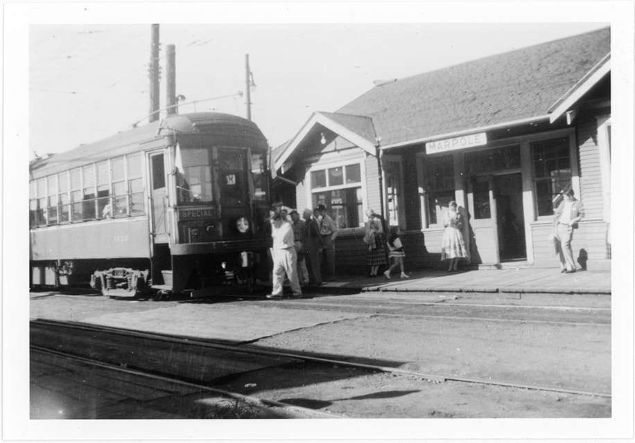
British Columbia Electric Railway tram 1223
https://search.heritageburnaby.ca/link/museumdescription1112
- Repository
- Burnaby Village Museum
- Date
- [October 1957]
- Collection/Fonds
- Burnaby Village Museum Photograph collection
- Description Level
- Item
- Physical Description
- 1 photograph : col. ; 12.5 x 17.9 cm
- Scope and Content
- Photograph of the exterior of the British Columbia Electric Railway Company Interurban tram no. 1223 at Marpole station in Vancouver. There are people standing by the tram, and a conductor is climbing onto the tram from the front.
- Repository
- Burnaby Village Museum
- Collection/Fonds
- Burnaby Village Museum Photograph collection
- Description Level
- Item
- Physical Description
- 1 photograph : col. ; 12.5 x 17.9 cm
- Scope and Content
- Photograph of the exterior of the British Columbia Electric Railway Company Interurban tram no. 1223 at Marpole station in Vancouver. There are people standing by the tram, and a conductor is climbing onto the tram from the front.
- Subjects
- Transportation - Electric Railroads
- Geographic Access
- Vancouver
- Accession Code
- HV972.202.3
- Access Restriction
- No restrictions
- Reproduction Restriction
- May be restricted by third party rights
- Date
- [October 1957]
- Media Type
- Photograph
- Scan Resolution
- 600
- Scan Date
- 2023-04-25
- Notes
- Title based on contents of photograph
- An annotation on the back of the photograph reads, "BCER 1223 (1232 in background) / Marpole BC / Oct. 57."
Images
![British Columbia Electric Railway tram 1223, [October 1957] thumbnail](/media/hpo/_Data/_BVM_Images/1971/197202020003.jpg)

Map of South Western Part of British Columbia
https://search.heritageburnaby.ca/link/museumdescription8688
- Repository
- Burnaby Village Museum
- Date
- 1897
- Collection/Fonds
- Burnaby Village Museum Map collection
- Description Level
- Item
- Physical Description
- 1 map : col. ink on paper ; 68 x 88 cm
- Scope and Content
- Item consists of a "MAP OF THE SOUTH-WESTERN PART OF BRITISH COLUMBIA”. Map identifies geographic land districts of New Westminster District; Coast District; Lillooet District; Yale District, Kamloops Division, Yale Division and districts on Vancouver Island. Map also includes the northern portions…
- Repository
- Burnaby Village Museum
- Collection/Fonds
- Burnaby Village Museum Map collection
- Description Level
- Item
- Physical Description
- 1 map : col. ink on paper ; 68 x 88 cm
- Material Details
- Scale [1:633600]
- Scope and Content
- Item consists of a "MAP OF THE SOUTH-WESTERN PART OF BRITISH COLUMBIA”. Map identifies geographic land districts of New Westminster District; Coast District; Lillooet District; Yale District, Kamloops Division, Yale Division and districts on Vancouver Island. Map also includes the northern portions of the State of Washington below the 49th parallel.
- Publisher
- The Colonist Litho Victoria B.C.
- Responsibility
- Martin, George Bohun
- Accession Code
- BV993.12.12
- Access Restriction
- No restrictions
- Reproduction Restriction
- No known restrictions
- Date
- 1897
- Media Type
- Cartographic Material
- Scan Resolution
- 600
- Scan Date
- 2023-08-17
- Notes
- Transcribed title
- Scale equals 1 inch to 10 miles
- "Compiled and drawn by direction of the Honouable G.B. Martin, Chief Commissioner of Lands and Works, Victoria, B.C."
- Signed by Surveyor General "Tom Kains"
Zoomable Images

![Four men standing on ʷməθkʷəy̓əm (Musqueam) First Nation farmland, [1951] (date of original), copied 2017 thumbnail](/media/hpo/_Data/_BVM_Images/2017/2017_0036_0005_001.jpg?width=280)
Four men standing on ʷməθkʷəy̓əm (Musqueam) First Nation farmland
https://search.heritageburnaby.ca/link/museumdescription4254
- Repository
- Burnaby Village Museum
- Date
- [1951] (date of original), copied 2017
- Collection/Fonds
- Burnaby Village Museum Photograph collection
- Description Level
- Item
- Physical Description
- 1 photograph (tiff) : 600 dpi
- Scope and Content
- Photograph of four men standing in farming clothing on leased farm land of the ʷməθkʷəy̓əm (Musqueam) First Nation. From L-R: Chan Kow Hong, Mr. Wong (Josephine Hong's uncle), Mr. Leong (Josephine Hong's uncle) and Gay Tim Hong. Planting crates evident on farmland in background.
- Repository
- Burnaby Village Museum
- Collection/Fonds
- Burnaby Village Museum Photograph collection
- Description Level
- Item
- Physical Description
- 1 photograph (tiff) : 600 dpi
- Scope and Content
- Photograph of four men standing in farming clothing on leased farm land of the ʷməθkʷəy̓əm (Musqueam) First Nation. From L-R: Chan Kow Hong, Mr. Wong (Josephine Hong's uncle), Mr. Leong (Josephine Hong's uncle) and Gay Tim Hong. Planting crates evident on farmland in background.
- History
- Josephine Hong was born to Sui Ha Hong and Chan Kow Hong. The Hong Family had seven children, oldest to youngest: Pauline, Josephine, Catherine, Norine, Gary, Darlene, and Marlene. The family runs Hop-On Farm on Marine Drive in Burnaby. Many Hong family members worked on the farm including Josephine Hong's grandfather, Gay Tim Hong, and uncles. Her great-grandfather was Sui Wing Hong.
- Geographic Access
- Byrne Road
- Accession Code
- BV017.36.5
- Access Restriction
- No restrictions
- Reproduction Restriction
- May be restricted by third party rights
- Date
- [1951] (date of original), copied 2017
- Media Type
- Photograph
- Historic Neighbourhood
- Fraser Arm (Historic Neighbourhood)
- Related Material
- See Oral History Interview-BV020.6.1
- Scan Resolution
- 600
- Scan Date
- 12/3/2017
- Scale
- 100
- Notes
- Title based on contents of photograph.
Images
![Four men standing on ʷməθkʷəy̓əm (Musqueam) First Nation farmland, [1951] (date of original), copied 2017 thumbnail](/media/hpo/_Data/_BVM_Images/2017/2017_0036_0005_001.jpg)
![Interview with Josephine Chow by Denise Fong February 7, 2020, [1900-2020] (interview content), interviewed Feb. 7, 2020 thumbnail](/media/hpo/_Data/_BVM_Images/2017/2017_0036_0004_001.jpg?width=280)
Interview with Josephine Chow by Denise Fong February 7, 2020
https://search.heritageburnaby.ca/link/museumdescription12337
- Repository
- Burnaby Village Museum
- Date
- [1900-2020] (interview content), interviewed Feb. 7, 2020
- Collection/Fonds
- Burnaby Village Museum fonds
- Description Level
- Item
- Physical Description
- 1 sound recording (mp3) (00:43:19 min.)
- Scope and Content
- Recording consists of an interview with Josephine Chow (nee Hong) conducted by BVM researcher Denise Fong at the Burnaby Village Museum. Josephine describes her family history and recollects her childhood experiences in 1950s and 60s while growing with her family on their "Hop On" farm in Burnaby. …
- Repository
- Burnaby Village Museum
- Collection/Fonds
- Burnaby Village Museum fonds
- Series
- Museum Oral Histories series
- Subseries
- Chinese Canadians in Burnaby subseries
- Description Level
- Item
- Physical Description
- 1 sound recording (mp3) (00:43:19 min.)
- Material Details
- Interviewer: Denise Fong Interviewee: Josephine Chow Location of Interview: Burnaby Village Museum Interview Date: February 7, 2020 Total Number of Tracks: 1 Total Length of all Tracks: 00:43:19
- Scope and Content
- Recording consists of an interview with Josephine Chow (nee Hong) conducted by BVM researcher Denise Fong at the Burnaby Village Museum. Josephine describes her family history and recollects her childhood experiences in 1950s and 60s while growing with her family on their "Hop On" farm in Burnaby. The farm is situated in the Big Bend area along Marine Drive and is still in operation today. 0:00-08:45 Josephine Chow provides some historical background on the history of “Hop On Farm” and her family in British Columbia. She tells of how her grandfather Gay Tim Hong and three partners pooled money together to purchase twelve acres on Marine Drive in 1951. Prior to this, most of them farmed on the ʷməθkʷəy̓əm (Musqueam) First Nation Reserve for 20-30 years. It all began when her great grandfather Sui Wing Hong, first came to Canada from China and slowly brought over her grandfather, father and other members of the family. Her grandfather, Gay Tim Hong went back and forth between Canada and China at least four times since he and her grandmother had four children including her father, who was born in 1931. Her father came to Canada at 10 years of age to live with his father. Josephine’s great grandfather came to Vancouver from Zhongshan county in Canton Province (also known as Guangdong). 8:46- 14:20 Josephine provides the names of her siblings from the eldest to the youngest; Pauline, Josephine (herself), Catherine, Noreen, Gary, Darlene and Marlene. She describes what life was like on the farm with her parents working from sunrise to sunset. The family farmed vegetable produce taking orders from local stores in the lower mainland. Often the children helped their parents with the orders starting at eight or nine years of age. Other workers on the farm travelled by bus from Vancouver’s Chinatown. She also tells of how her father was an animal lover and raised chickens, pigeons, geese, koy, goldfish and dogs. 14: 21 – 16:56 Josephine describes what Burnaby was like during the time that she grew up in the late 1950s. She explains that Burnaby was very quiet with nothing being open on Sundays. On the farm, she and her siblings would entertain themselves by playing games like soccer, baseball and kick ball or also by catching frogs, snails, caterpillars and ladybugs. There were neighbours living on Marine Drive and almost every house had someone who we went to the same elementary school. The neighbourhood children would often come to play with them on their farm. 16:56- 26:47 Josephine describes how when they were young there were farms all around them and how on Sunday drives with her father, they would go to feed horses or look at the cows. Josephine shares that her elder sister Pauline was the only one born in China and how when she first arrived that she lived on the ʷməθkʷəy̓əm (Musqueam) First Nations Reserve with their parents before they moved to Burnaby. Josephine recollects that most of her friends were farmer’s kids from the neighbourhood but while in school, she had more Caucasian friends. Josephine and her siblings attended Glenwood Elementary on Marine Drive and later Junior Secondary at McPherson Park (grades 8-10) and Burnaby South Senior Secondary (grades 11-12. ). She shares some of her experiences while attending school. She said that there were about a dozen Asians in school with her, mostly from farming families in the “Flats”. 26:48- 30:45 Josephine describes what life was like for her and her siblings after school. They often helped on the farm when they got home, usually taking care of orders for green onions. Her mother made dinner and did all of the cooking for family and workers on the farm as well as working in the fields. Her father did all of the grocery shopping in Vancouver’s Chinatown two or three times per week where he purchased meat and fish. She says that her grandfather, often travelled by bus every Saturday or Sunday to meet up with friends in Chinatown. Extracurricular activities for her and her siblings included volley ball and soccer as long as it didn’t interfere with their work schedule on the farm. 30:46- 37:03 Josephine describes what occurred while living at home, the food they ate, shopping and attending Chinese school. Her mother cooked only Chinese food, she didn’t know how to cook “Western food”. For school lunches, the kids made their own sandwiches. She tells of a Chinese language school arranged by Mrs. Joe [sic] who lived on Gilley Road and was Canadian born Chinese. Mrs. Joe [sic] also arranged an English class for farmer’s wives on Tuesday nights in which her mother attended. Josephine recollects learning Mandarin from Mrs. Joe [sic] a few days a week after her regular school. Chinese school took place at Riverway School on Meadow Avenue in Burnaby. Mrs. Joe also taught them a lot about Chinese culture including Kung Fu, Chinese Dance and Chinese brush painting. 37:04- 39:39 Josephine describes Medical Care for her and her family in the 1950s and 1960s. She tells of a female Chinese doctor in Vancouver, Dr. Madeline Chung. Dr. Chung was responsible for delivering a lot of Chinese babies including Josephine. The family also visited herbalists in Vancouver Chinatown. They would often buy herbs for colds etc. Josephine also tells of how her parents stayed in touch with family in China by writing letters. Her mother’s family, including her parents and siblings were still in China while most of her father’s family were here in Canada. 39:40- 43:19 – In closing, Josephine shares how life is much busier now and of how she misses the quietness of her days growing up. She briefly describes her life on the family farm now and how different it is from when her parents worked the farm. She explains how farming methods have changed and how they don’t have to work as hard as her parents did.
- History
- Interviewee biography: Josephine Chow (nee Hong) is the second eldest child of Chan Kow Hong and Sui Ha Hong. In 1925, Josephine's grandfather, Gay Tim Hong immigrated to Canada from Zhongshan county in Canton Province (also known as Guangdong). In 1952, her father, Chan Kow Hong joined his father, Gay Tim Hong and by 1953, he established "Hop On Farms" in the Big Bend area of Burnaby near Marine Drive. Josephine grew up on the farm with her parents and six siblings; Pauline, Catherine, Norine, Gary, Darlene and Marlene. In 1969, Josephine's elder sister Pauline and her husband Jack Chan took over the family farm and in 1972 their father and grandfather moved to Kamloops to open a restaurant. As an adult, Josephine worked in several different areas including owning and running her own Aesthetics business. Josephine eventually retired and returned to the farm to assist her siblings. The farm is still in operation. Interviewer biography: Denise Fong is a historical researcher at Burnaby Village Museum. She has degrees in Anthropology (BA) and Archaeology (MA), and is completing her doctoral degree at UBC in Interdisciplinary Studies. Her primary research interests are in Chinese Canadian history and critical heritage studies. She is the co-curator of BVM’s “Across the Pacific” exhibition, and the Museum of Vancouver’s “A Seat at the Table – Chinese Immigration and British Columbia”.
- Creator
- Burnaby Village Museum
- Subjects
- Persons - Chinese Canadians
- Agriculture - Farms
- Education
- Buildings - Schools
- First Nations reserves - British Columbia
- Names
- Chow, Josephine
- Glenwood Elementary School
- McPherson Park Junior Secondary School
- ʷməθkʷəy̓əm (Musqueam)
- Responsibility
- Fong, Denise
- Geographic Access
- Byrne Road
- Accession Code
- BV020.6.1
- Access Restriction
- No restrictions
- Reproduction Restriction
- No known restrictions
- Date
- [1900-2020] (interview content), interviewed Feb. 7, 2020
- Media Type
- Sound Recording
- Historic Neighbourhood
- Fraser Arm (Historic Neighbourhood)
- Planning Study Area
- Big Bend Area
- Related Material
- See also BV017.36*
- Scan Resolution
- 600
- Scan Date
- 12/3/2017
- Scale
- 100
- Notes
- Title based on contents of interview
- Photograph info: Gary Hong and Chan Kow Hong harvesting celery at Hop-On Farms [1969]. BV017.36.4
Images
![Interview with Josephine Chow by Denise Fong February 7, 2020, [1900-2020] (interview content), interviewed Feb. 7, 2020 thumbnail](/media/hpo/_Data/_BVM_Images/2017/2017_0036_0004_001.jpg)
Audio Tracks
Interview with Josephine Chow by Denise Fong February 7, 2020, [1900-2020] (interview content), interviewed Feb. 7, 2020
Interview with Josephine Chow by Denise Fong February 7, 2020, [1900-2020] (interview content), interviewed Feb. 7, 2020
https://search.heritageburnaby.ca/media/hpo/_Data/_BVM_Sound_Recordings/Oral_Histories/2020_0006_0001_001.mp3![Mary Stanley and two women with totem pole, [195-] thumbnail](/media/hpo/_Data/_BVM_Images/2022/2022_0032_0669_001.jpg?width=280)
Mary Stanley and two women with totem pole
https://search.heritageburnaby.ca/link/museumdescription20247
- Repository
- Burnaby Village Museum
- Date
- [195-]
- Collection/Fonds
- Esther Love Stanley fonds
- Description Level
- Item
- Physical Description
- 1 photograph : b&w ; 9 x 9.5 cm
- Scope and Content
- Photograph of Mary (Stanley) Pearson (left) standing with two women on wooden platform in front of a totem pole.
- Repository
- Burnaby Village Museum
- Collection/Fonds
- Esther Love Stanley fonds
- Description Level
- Item
- Physical Description
- 1 photograph : b&w ; 9 x 9.5 cm
- Scope and Content
- Photograph of Mary (Stanley) Pearson (left) standing with two women on wooden platform in front of a totem pole.
- Accession Code
- BV022.32.669
- Access Restriction
- No restrictions
- Reproduction Restriction
- No known restrictions
- Date
- [195-]
- Media Type
- Photograph
- Scan Resolution
- 600
- Scan Date
- 2023-08-29
- Notes
- Title based on contents of photograph
- Photograph is part of Esther Love Stanley photograph album 2 (BV032.22.431)
- Note in black ink on verso of photograph reads: "MARY"
- Note in white ink on album page reads: "MARY"
Images
![Mary Stanley and two women with totem pole, [195-] thumbnail](/media/hpo/_Data/_BVM_Images/2022/2022_0032_0669_001.jpg)
![Survey and Subdivision plans in New Westminster District Group 1 & Group 2 - Port Moody, Surrey
, [1898-1910] thumbnail](/media/hpo/_Data/_BVM_Cartographic_Material/1977/1977_0093_0073_001.jpg?width=280)
Survey and Subdivision plans in New Westminster District Group 1 & Group 2 - Port Moody, Surrey
https://search.heritageburnaby.ca/link/museumdescription7042
- Repository
- Burnaby Village Museum
- Date
- [1898-1910]
- Collection/Fonds
- Burnaby Village Museum Map collection
- Description Level
- File
- Physical Description
- 10 plans : graphite and ink on paper and linen; various sizes mounted on 2 sides of cardboard 76 x 102 cm
- Scope and Content
- File consists of a large board with four plans in New Westminster District mounted on one side and six plans mounted on the other side. Side A: 1. Plan : black ink and graphite on paper ; 46.5 x 37.5 cm. Title reads: "Bon Accord Hatchery / Sec 6 B5N R1W". Signed by Albert J. Hill P.L.S. August 1…
- Repository
- Burnaby Village Museum
- Collection/Fonds
- Burnaby Village Museum Map collection
- Description Level
- File
- Physical Description
- 10 plans : graphite and ink on paper and linen; various sizes mounted on 2 sides of cardboard 76 x 102 cm
- Material Details
- Scales vary (One chain equals 792 inches)
- Indexed number on tape on edge of board reads "73"
- Scope and Content
- File consists of a large board with four plans in New Westminster District mounted on one side and six plans mounted on the other side. Side A: 1. Plan : black ink and graphite on paper ; 46.5 x 37.5 cm. Title reads: "Bon Accord Hatchery / Sec 6 B5N R1W". Signed by Albert J. Hill P.L.S. August 12, 1903. Plan covers land identified as Section 6, Section 7, Located along the south shore of the Fraser River in Port Mann (Geographic location: Surrey). 2. Plan : black ink and graphite on paper ; 36 x 31 cm. Title reads: "Survey of Portions of Sec. 20 B5N R2W". Plan is stamped in red ink: "Albert J. Hill, Civil Engineer". Scale 4 chains = 1 inch. 3. Plan : black ink on linen ; 14 x 23 cm. Title reads:"Port Moody". Plan covers sections in Lot 191 (District Lot 191) bordered by Burrard Inlet to the west and Lot 235 and Lot 233 to the south. Streets identified include Water Street, Beauregard Street, Yonge Street, Clinton Street and Oxford Street. 4. Plan: graphite and ink on paper ; 43.5 x 64.5 cm. Title reads: "Sketch Plan Approved by Council [sic] / _[sic]1898". (No identifying geographic landmarks provided) Side B: 1. Plan : graphite on paper ; 53.5 x 31 cm. Title reads: "Plan of Lot 13, Gr. II, N.W. Dist". Sketch plan covers area along the Fraser River in District Lot 13, New Westminster District, Group 2. District Lot 13 is bordered by District Lot 14 (to the west) and Lot 12 (to the east). Natural geographic features within District Lot 13 are noted as "dense brush and fallen timber / sallal / rough spruce and cedar / swamp / fine alder / sallal / fine alder bottom land / fine brook". Scale: 3 chains = 1 inch (Geographic location: Surrey) 2. Plan : black ink on paper ; 50.5 x 34.5 cm. Title reads: "Indian Reserve / Opposite / New Westminster". Plan covers area on the south shore of the Fraser River in New Westminster District Group 2 in an area known as Brownsville. Lots are identified as District Lots 1, 2, 3, 4, 18, 17 and 8 and Sections A and B. Two areas of land are noted as "Indian Reserve"; one 6.3 acre parcel and one 104.25 acre parcel, both within District Lot 1. Note on plan reads: "N.B. this plan shows reserves and adjacent properties as they are on the ground". (Geographic location: Surrey) 3. Plan : black and col. ink on paper ; 19.5 x 31.5 cm. Title reads: "Bon Accord Road". Plan shows elevation. "Average section 10 feet = 1 inch". Plan is stamped in red ink: "Albert J. Hill, Civil Engineer and Provincial Land Surveyor, New Westminster, B.C." (Geographic location: Surrey) 4. Plan : black and col. ink on linen ; 16.5 x 25.5 cm. (no formal title) Plan covers area of Section 35, south of Yale Wagon Road and east of Quible Road. Plan is signed by "Albert J. Hill / B.C.L.S." (Geographic location: Surrey) 5. Plan: black and col. ink on linen ; 22.5 x 22.5 cm. (no formal title) Plan covers area between Yale Road and Townline Road in Surrey. Scale: 4 chains = 1 inch. Plan is signed by Albert J. Hill B.C.L.S. [190-] (Geographic location: Surrey) 6. Plan : graphite on paper ; 24 x 54 cm. (no formal title) Plan covers sectioned areas along Bon Accord Road. Sections are identified as " Sec. 8 / T.F. Patterson"; "Sec. 9 / Russell"; "Elliott_Burnett_Crean / Sec. 16"; "Dom. Govt. / Sec. 17". (Geographic location: Surrey, beneath the Port Mann bridge)
- Names
- ʷməθkʷəy̓əm (Musqueam)
- Accession Code
- HV977.93.73
- Access Restriction
- No restrictions
- Reproduction Restriction
- No known restrictions
- Date
- [1898-1910]
- Media Type
- Cartographic Material
- Scan Resolution
- 600
- Scan Date
- 2023-06-26
- Notes
- Title based on contents of file
- Note re plan 2B: The sight of Brownsville was also the former site of the Qayqayt First Nation and one of the main summer villages of the Kwantlen and ʷməθkʷəy̓əm (Musqueam) peoples
Zoomable Images
![Survey and Subdivision plans in New Westminster District Group 1 & Group 2 - Port Moody, Surrey
, [1898-1910] thumbnail](/media/hpo/_Data/_BVM_Cartographic_Material/1977/1977_0093_0073_003_seadragon/1977_0093_0073_003.jpg?w=280)
Survey and Subdivision plans in New Westminster District Group 1 & Group 2 - Port Moody, Surrey , [1898-1910]
Zoom into Image
![Survey and Subdivision plans in New Westminster District Group 2 - Surrey, Delta
, [1898-1910] thumbnail](/media/hpo/_Data/_BVM_Cartographic_Material/1977/1977_0093_0078_001.jpg?width=280)
Survey and Subdivision plans in New Westminster District Group 2 - Surrey, Delta
https://search.heritageburnaby.ca/link/museumdescription7047
- Repository
- Burnaby Village Museum
- Date
- [1898-1910]
- Collection/Fonds
- Burnaby Village Museum Map collection
- Description Level
- File
- Physical Description
- 10 plans : graphite and ink on paper and linen; various sizes mounted on 2 sides of cardboard 76 x 102 cm
- Scope and Content
- File consists of a large board with four plans in New Westminster District mounted on one side and six plans mounted on the other side. Side A: 1. Plan : black ink on paper with colour (no formal title). Plan covers area in New Westminster District, Group 2 situated along the south shore of the …
- Repository
- Burnaby Village Museum
- Collection/Fonds
- Burnaby Village Museum Map collection
- Description Level
- File
- Physical Description
- 10 plans : graphite and ink on paper and linen; various sizes mounted on 2 sides of cardboard 76 x 102 cm
- Material Details
- Scales vary
- Indexed number on tape on edge of board reads "78"
- Scope and Content
- File consists of a large board with four plans in New Westminster District mounted on one side and six plans mounted on the other side. Side A: 1. Plan : black ink on paper with colour (no formal title). Plan covers area in New Westminster District, Group 2 situated along the south shore of the Fraser River identified as "Indian Reserve / Turner 1868" situated in District Lot 1 between District Lot 2 identified as "Mohun's Line" and "Herring's Line" bordered by lots B and A. Includes note "see plan of subdivision of Lots 3 & 4 Gr. 2". (Geographic location: Surrey) 2. Plan : graphite on paper ; Title reads: "B5N R2W, Sec.26_Sec. 28 / Sec. 35_Sec.36". Plan covers a 60 acre parcel in Sec. 35 with Yale wagon road to the south. Scale: 6 chains = 1 inch (Geographic location: Surrey) 3. Plan : black ink on paper ; Title reads: "Survey for Proposed Highway in Indian Reserve Surrey". Plan covers area of land to the northwest of Lot 2 along the shore of the Fraser River and identfies route of proposed highway, proposed tramway as well at the Great Northern Railway and bridge. Scale: 2 chains = 1 inch 4. Plan : black ink on red lined graphing paper ; Title reads: "Sketch Plan Showing Section of Great Northern R. of W. at Point of Crossing of Proposed Ditch". Plan covers area of Lot 2 in New Westminster District, Group 2. (Surrey) Scale: 1 inch = 5 feet. (Geographic location: Surrey) Side B: 1. Plan : black ink on paper ; Title reads: "Plan of Subdivision of a Portion of Section 13, TP2, Surrey Municipality, New Westminster District, B.C.". Plan covers land bordered by Coast Meridian Road (to the east), Bose Road (to the south) and Pike Road (to the west). Surveyed for D.S. Bayners, Nov. 24, 1908. Scale: 5 chains= 1 inch 2. Plan : black ink on linen with colour ; Title reads: "Traverse of the Waterline in front of Lots 3 and 4, Group 2, New Westminster District with G.N. Railway Right of Way". Plan covers area along the southern shore of the Fraser River with a road crossing the Great Northern Railway and leading to a wharf. Scale: 100 feet = 1 inch (Geographic location: Surrey) 3. Plan : black ink on paper ; Title reads: "Survey of the South Boundary of Sec. 12, Township 2, New Westminster District". Plan covers area south of Bose Road and west of Coast Meridean Road and north of McClellen Road. Scale: 400 feet = 1 inch. Sec.12 (Geographic location: Surrey) 4. Plan : graphite on paper ; Title reads: "Plan of Subdivisioin of a part of S.E. 1/4 of Sec. 7, TP 8". Plan covers area of Section 7 in New Westminster District, Group 2, Township 8. Streets are identified running through lot including, Langley Ave., Robinson Ave, Melrose Ave., Hawthorne Ave., Broadway, Bond Ave., Mable Ave., Breene Ave. and McLelland Ave. and Clover Valley Road. Scale: 200 feet = 1 inch. Note in black ink reads: See Bd. 166 for blue print. (Geographic location: Surrey) 5. Plan : graphite on linen ; Title reads: "Sec.20, B5N R2W". Plan covers area north of Yale Road and is subdivided into parts identified as A, B, C, D, E, and unknown. (Geographic location: Surrey) 6. Plan : black ink and graphite on paper ; (no formal title) Plan covers lots surveyed along Ladner Road identified as A, B and Lots 13, 12 and 11. [Geographic location: Delta]
- Accession Code
- HV977.93.78
- Access Restriction
- No restrictions
- Reproduction Restriction
- No known restrictions
- Date
- [1898-1910]
- Media Type
- Cartographic Material
- Scan Resolution
- 600
- Scan Date
- 2023-06-26
- Notes
- Title based on contents of file
- Note re plans 1A & 3A: The sight of Brownsville was also the former site of the Qayqayt First Nation and one of the main summer villages of the Kwantlen and ʷməθkʷəy̓əm (Musqueam) peoples
- Scale is measured in chains and feet. (One chain equals 792 inches)
Zoomable Images
![Survey and Subdivision plans in New Westminster District Group 2 - Surrey, Delta
, [1898-1910] thumbnail](/media/hpo/_Data/_BVM_Cartographic_Material/1977/1977_0093_0078_003_seadragon/1977_0093_0078_003.jpg?w=280)
Survey and Subdivision plans in New Westminster District Group 2 - Surrey, Delta , [1898-1910]
Zoom into Image
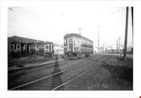
![BCER engine 942 with three men, [195-] thumbnail](/media/hpo/_Data/_BVM_Images/2012/2012_0018_0003_001.jpg?width=280)
BCER engine 942 with three men
https://search.heritageburnaby.ca/link/museumdescription2879
- Repository
- Burnaby Village Museum
- Date
- [195-]
- Collection/Fonds
- Burnaby Village Museum Photograph collection
- Description Level
- Item
- Physical Description
- 1 photograph : col. ; 9 x 9 cm
- Scope and Content
- Photogrpah of British Columbia Electric Railway (BCER) engine number 942 with engineers standing in front. Engineers are identified left to right as; Bud Conolly, Jim Sellers and Jim Donald. The engine is yellow, with three men standing in front of it.
- Repository
- Burnaby Village Museum
- Collection/Fonds
- Burnaby Village Museum Photograph collection
- Description Level
- Item
- Physical Description
- 1 photograph : col. ; 9 x 9 cm
- Scope and Content
- Photogrpah of British Columbia Electric Railway (BCER) engine number 942 with engineers standing in front. Engineers are identified left to right as; Bud Conolly, Jim Sellers and Jim Donald. The engine is yellow, with three men standing in front of it.
- Subjects
- Transportation - Locomotives
- Names
- British Columbia Electric Railway Company
- British Columbia Hydro and Power Authority
- Conolly, Bud
- Sellers, Jim
- Donald, Jim
- Accession Code
- BV012.18.3
- Access Restriction
- No restrictions
- Reproduction Restriction
- May be restricted by third party rights
- Date
- [195-]
- Media Type
- Photograph
- Scan Resolution
- 600
- Scan Date
- 13-Mar-2018
- Notes
- Title based on contents of photograph
- Note in blue ink on verso of photograph reads: "left to right / Bud Connolly / Jim Sellers / Jim Donald"
- Stamp in black ink on verso reads: "D626"
- Stamp in blue ink on verso reads: "WILLIAMS COLOR / PHOTO SERVICE / Vancouver, Canada"
Images
![BCER engine 942 with three men, [195-] thumbnail](/media/hpo/_Data/_BVM_Images/2012/2012_0018_0003_001.jpg)
At Tucks Station, Richmond
https://search.heritageburnaby.ca/link/museumdescription1221
- Repository
- Burnaby Village Museum
- Date
- June 1957
- Collection/Fonds
- Burnaby Village Museum Photograph collection
- Description Level
- Item
- Physical Description
- 1 photograph : col. ; 8.5 x 8.5 cm
- Scope and Content
- Photograph of British Columbia Electric Railway Company trams no. 1232 (and 1231) reaching Tucks Station in Richmond.
- Repository
- Burnaby Village Museum
- Collection/Fonds
- Burnaby Village Museum Photograph collection
- Description Level
- Item
- Physical Description
- 1 photograph : col. ; 8.5 x 8.5 cm
- Scope and Content
- Photograph of British Columbia Electric Railway Company trams no. 1232 (and 1231) reaching Tucks Station in Richmond.
- Subjects
- Transportation - Electric Railroads
- Accession Code
- BV992.23.14
- Access Restriction
- Restricted access
- Reproduction Restriction
- May be restricted by third party rights
- Date
- June 1957
- Media Type
- Photograph
- Scan Resolution
- 600
- Scan Date
- 01-Jun-09
- Scale
- 100
- Photographer
- Webster, Robert D. "Bob"
- Notes
- Title based on contents of photograph
- Note on verso of photograph reads: "BCER 1232-1231/ RUCKS BC 6/57"
- Stamp on verso of photograph reads: "BOB WEBSTER/ 9068 - 146th STREET/ SURREY, B.C. CANADA/ 584-9495 V3R 3S8/ RAILROAD PHOTOGRAPHY"
Images


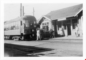
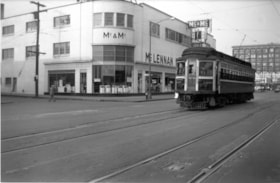
B.C. Electric Railway no. 1232 coming into New Westminster Depot
https://search.heritageburnaby.ca/link/museumdescription2895
- Repository
- Burnaby Village Museum
- Date
- 12 Feb. 1956
- Collection/Fonds
- Burnaby Village Museum Photograph collection
- Description Level
- Item
- Physical Description
- 1 photograph : b&w ; 9 x 9 cm
- Scope and Content
- Photograph of B.C. Electric Railway tram no.1232 coming into New Westminster Depot off the Marpole Line. The Mc & Mc store is visible in the background.
- Repository
- Burnaby Village Museum
- Collection/Fonds
- Burnaby Village Museum Photograph collection
- Description Level
- Item
- Physical Description
- 1 photograph : b&w ; 9 x 9 cm
- Scope and Content
- Photograph of B.C. Electric Railway tram no.1232 coming into New Westminster Depot off the Marpole Line. The Mc & Mc store is visible in the background.
- Subjects
- Transportation - Electric Railroads
- Accession Code
- BV012.36.3
- Access Restriction
- No restrictions
- Reproduction Restriction
- No known restrictions
- Date
- 12 Feb. 1956
- Media Type
- Photograph
- Scan Resolution
- 600
- Scan Date
- 2022-07-26
- Notes
- Title based on contents of photograph
- Typewritten text on verso of photograph reads: "BCER #1232 coming into New Westminster Depot / off the Marpole / Line. / Sunday, Feburary 12, 1956"
Images
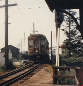
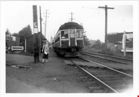
B.C. Electric Railway tram at Marpole Station
https://search.heritageburnaby.ca/link/museumdescription2899
- Repository
- Burnaby Village Museum
- Date
- 28 Sep. 1957
- Collection/Fonds
- Burnaby Village Museum Photograph collection
- Description Level
- Item
- Physical Description
- 1 photograph : b&w ; 9 x 13 cm
- Scope and Content
- Photograph of B.C. Electric Railway tram at Marpole Station on the B.C. Electric Railway Lulu Island branch.
- Repository
- Burnaby Village Museum
- Collection/Fonds
- Burnaby Village Museum Photograph collection
- Description Level
- Item
- Physical Description
- 1 photograph : b&w ; 9 x 13 cm
- Scope and Content
- Photograph of B.C. Electric Railway tram at Marpole Station on the B.C. Electric Railway Lulu Island branch.
- Subjects
- Transportation - Electric Railroads
- Accession Code
- BV012.36.7
- Access Restriction
- No restrictions
- Reproduction Restriction
- No known restrictions
- Date
- 28 Sep. 1957
- Media Type
- Photograph
- Scan Resolution
- 600
- Scan Date
- 2022-07-26
- Notes
- Title based on contents of photograph
- Typewritten text on verso of photograph reads: "A busy scene at the Marpole Station on the / B.C.E.R. Lulu Island branch, as with white / flags up, Special B.C.E.R. #1222, with a gro (sic) / group of rail fans on board, pauses for / orders, before proceeding on. / September 28, 1957"
Images
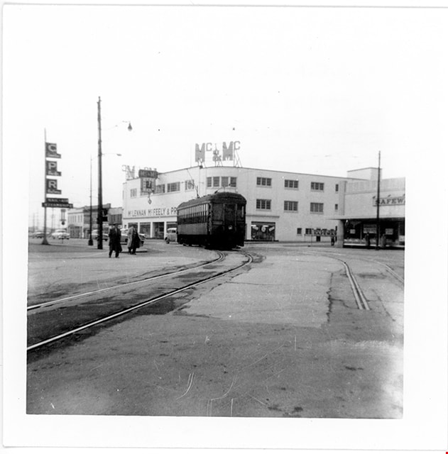
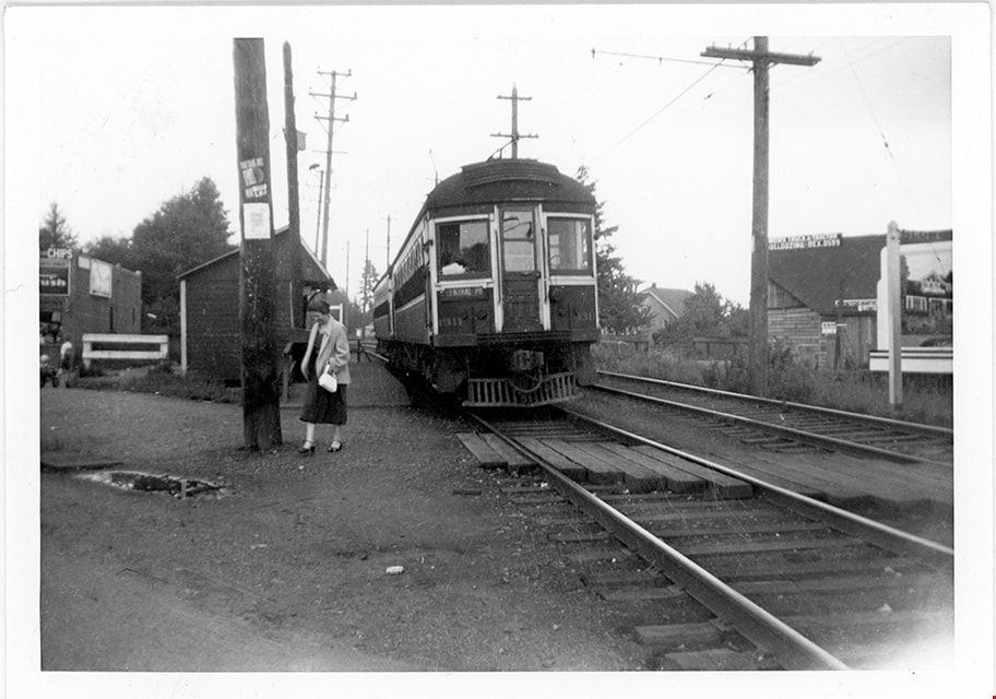
B.C. Electric Railway tram no. 1207 heading west to Marpole
https://search.heritageburnaby.ca/link/museumdescription2901
- Repository
- Burnaby Village Museum
- Date
- 1955
- Collection/Fonds
- Burnaby Village Museum Photograph collection
- Description Level
- Item
- Physical Description
- 1 photograph : b&w ; 9 x 13.5 cm
- Scope and Content
- Photograph of B.C. Electric Railway tram no. 1207 heading west towards Marpole on a Sunday afternoon in 1955. The Mc & Mc (McLennan & McFeeley) store in New Westminster is visible behind.
- Repository
- Burnaby Village Museum
- Collection/Fonds
- Burnaby Village Museum Photograph collection
- Description Level
- Item
- Physical Description
- 1 photograph : b&w ; 9 x 13.5 cm
- Scope and Content
- Photograph of B.C. Electric Railway tram no. 1207 heading west towards Marpole on a Sunday afternoon in 1955. The Mc & Mc (McLennan & McFeeley) store in New Westminster is visible behind.
- Subjects
- Transportation - Electric Railroads
- Accession Code
- BV012.36.9
- Access Restriction
- No restrictions
- Reproduction Restriction
- No known restrictions
- Date
- 1955
- Media Type
- Photograph
- Scan Resolution
- 600
- Scan Date
- 2022-07-26
- Notes
- Title based on contents of photograph
- Typewritten text on verso of photograph reads: "After threading the cross over from the New / Westminster depot, BCER #1207 heads west / to Marpole on a Sunday after noon in 1955. / #1207 has been brought back from the USA and / is now being refurbished in the POCO garage / of B.C. Transit"
Images

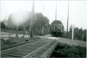
B.C. Electric Railway tram no. 1216 near Byrne Road stop
https://search.heritageburnaby.ca/link/museumdescription2910
- Repository
- Burnaby Village Museum
- Date
- Oct. 1956
- Collection/Fonds
- Burnaby Village Museum Photograph collection
- Description Level
- Item
- Physical Description
- 1 photograph : b&w print ; 9 x 13.5 cm
- Scope and Content
- Photograph of B.C. Electric Railway tram no. 1216 approaching a level crossing and the Byrne Road stop on the New Westminster to Marpole line.
- Repository
- Burnaby Village Museum
- Collection/Fonds
- Burnaby Village Museum Photograph collection
- Description Level
- Item
- Physical Description
- 1 photograph : b&w print ; 9 x 13.5 cm
- Scope and Content
- Photograph of B.C. Electric Railway tram no. 1216 approaching a level crossing and the Byrne Road stop on the New Westminster to Marpole line.
- Accession Code
- BV012.37.8
- Access Restriction
- No restrictions
- Reproduction Restriction
- May be restricted by third party rights
- Date
- Oct. 1956
- Media Type
- Photograph
- Scan Resolution
- 600
- Scan Date
- 2022-07-26
- Notes
- Title based on contents of photograph
- Typewritten text on verso of photograph reads: "On a partly foggy and frosty morning of / October 1956, B.C.E.R. #1216, westbound / to Vancouver on theNew Westminster Div - / ision of the Marpole Line pauses at the / Byrne Road Station."
Images

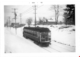
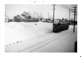
B.C. Electric Railway tram no. 1306 on Central Park Line
https://search.heritageburnaby.ca/link/museumdescription2902
- Repository
- Burnaby Village Museum
- Date
- 1952
- Collection/Fonds
- Burnaby Village Museum Photograph collection
- Description Level
- Item
- Physical Description
- 1 photograph : b&w ; 9 x 13 cm
- Scope and Content
- Phototgraph of B.C. Electric Railway tram no. 1306 running on the tracks between Earles Road and Collingwood west on the Central Park Line. The ground is covered with snow.
- Repository
- Burnaby Village Museum
- Collection/Fonds
- Burnaby Village Museum Photograph collection
- Description Level
- Item
- Physical Description
- 1 photograph : b&w ; 9 x 13 cm
- Scope and Content
- Phototgraph of B.C. Electric Railway tram no. 1306 running on the tracks between Earles Road and Collingwood west on the Central Park Line. The ground is covered with snow.
- Accession Code
- BV012.36.10
- Access Restriction
- No restrictions
- Reproduction Restriction
- No known restrictions
- Date
- 1952
- Media Type
- Photograph
- Scan Resolution
- 600
- Scan Date
- 2022-07-26
- Notes
- Title based on contents of photograph
- "Khulman built BCER #1306 / running between Earles Road and Collingwood / west on Central Park Line 1952 / Earles Road substation in background"
Images

B.C. Electric Railway tram no. 1309 tram on Central Park Line
https://search.heritageburnaby.ca/link/museumdescription2896
- Repository
- Burnaby Village Museum
- Date
- 1953
- Collection/Fonds
- Burnaby Village Museum Photograph collection
- Description Level
- Item
- Physical Description
- 1 photograph : b&w ; 9 x 13 cm
- Scope and Content
- Photograph of B.C. Electric Railway tram no. 1309 travelling along the Central Park Line westbound to Vancouver between Collingwood West and Earls Road after a winter storm. The tracks and hillside are covered with snow.
- Repository
- Burnaby Village Museum
- Collection/Fonds
- Burnaby Village Museum Photograph collection
- Description Level
- Item
- Physical Description
- 1 photograph : b&w ; 9 x 13 cm
- Scope and Content
- Photograph of B.C. Electric Railway tram no. 1309 travelling along the Central Park Line westbound to Vancouver between Collingwood West and Earls Road after a winter storm. The tracks and hillside are covered with snow.
- Accession Code
- BV012.36.4
- Access Restriction
- No restrictions
- Reproduction Restriction
- No known restrictions
- Date
- 1953
- Media Type
- Photograph
- Scan Resolution
- 600
- Scan Date
- 2022-07-26
- Notes
- Title based on contents of photograph
- Typewritten text on verso of photograph reads: "Home built B.C.E.R. #1309 hurries along / Central Park line westbound to Vancovuer / between Collingwood West and Earls Road / after a winter snow storm in 1953"
Images

B.C. Electric Railway tram no. 1311 at Jubilee Station
https://search.heritageburnaby.ca/link/museumdescription2900
- Repository
- Burnaby Village Museum
- Date
- 1952
- Collection/Fonds
- Burnaby Village Museum Photograph collection
- Description Level
- Item
- Physical Description
- 1 photograph : b&w ; 9 x 13 cm
- Scope and Content
- Photograph of B.C. Electric Railway tram no. 1311 at Jubilee Station on the Central Park Line westbound towards Vancouver.
- Repository
- Burnaby Village Museum
- Collection/Fonds
- Burnaby Village Museum Photograph collection
- Description Level
- Item
- Physical Description
- 1 photograph : b&w ; 9 x 13 cm
- Scope and Content
- Photograph of B.C. Electric Railway tram no. 1311 at Jubilee Station on the Central Park Line westbound towards Vancouver.
- Subjects
- Transportation - Electric Railroads
- Accession Code
- BV012.36.8
- Access Restriction
- No restrictions
- Reproduction Restriction
- No known restrictions
- Date
- 1952
- Media Type
- Photograph
- Scan Resolution
- 600
- Scan Date
- 2022-07-26
- Notes
- Title based on contents of photograph
- Typewritten text on verso of photograph reads: "B.C.E.R. #1311 and train at Jubilee Station / on Central Park Line westbound to Vancouver / 1952."
Images
![B.C. Electric Railway tram no. 1315 tram leaving New Westminster
, [1953] thumbnail](/media/hpo/_Data/_BVM_Images/2012/2012_0036_0005_001.jpg?width=280)
B.C. Electric Railway tram no. 1315 tram leaving New Westminster
https://search.heritageburnaby.ca/link/museumdescription2897
- Repository
- Burnaby Village Museum
- Date
- [1953]
- Collection/Fonds
- Burnaby Village Museum Photograph collection
- Description Level
- Item
- Physical Description
- 1 photograph : b&w ; 9 x 13 cm
- Scope and Content
- Photograph of B.C. Electric Railway tram no. 1315 tram leaving New Westminster station. The photographer is facing east and standing at the Columbia St. and Eighth Ave. inersection. There are many automobiles on Columbia Street..
- Repository
- Burnaby Village Museum
- Collection/Fonds
- Burnaby Village Museum Photograph collection
- Description Level
- Item
- Physical Description
- 1 photograph : b&w ; 9 x 13 cm
- Scope and Content
- Photograph of B.C. Electric Railway tram no. 1315 tram leaving New Westminster station. The photographer is facing east and standing at the Columbia St. and Eighth Ave. inersection. There are many automobiles on Columbia Street..
- Subjects
- Transportation - Electric Railroads
- Accession Code
- BV012.36.5
- Access Restriction
- No restrictions
- Reproduction Restriction
- No known restrictions
- Date
- [1953]
- Media Type
- Photograph
- Scan Resolution
- 600
- Scan Date
- 2022-07-26
- Notes
- Title based on contents of photograph
- Typewritten text on verso of photograph reads: "BCER #1315 leaves New Westminster / terminal west bound to Vancouver, / spring of 1953"
- Date stamp on recto of photograph reads: "Nov_64"
Images
![B.C. Electric Railway tram no. 1315 tram leaving New Westminster
, [1953] thumbnail](/media/hpo/_Data/_BVM_Images/2012/2012_0036_0005_001.jpg)
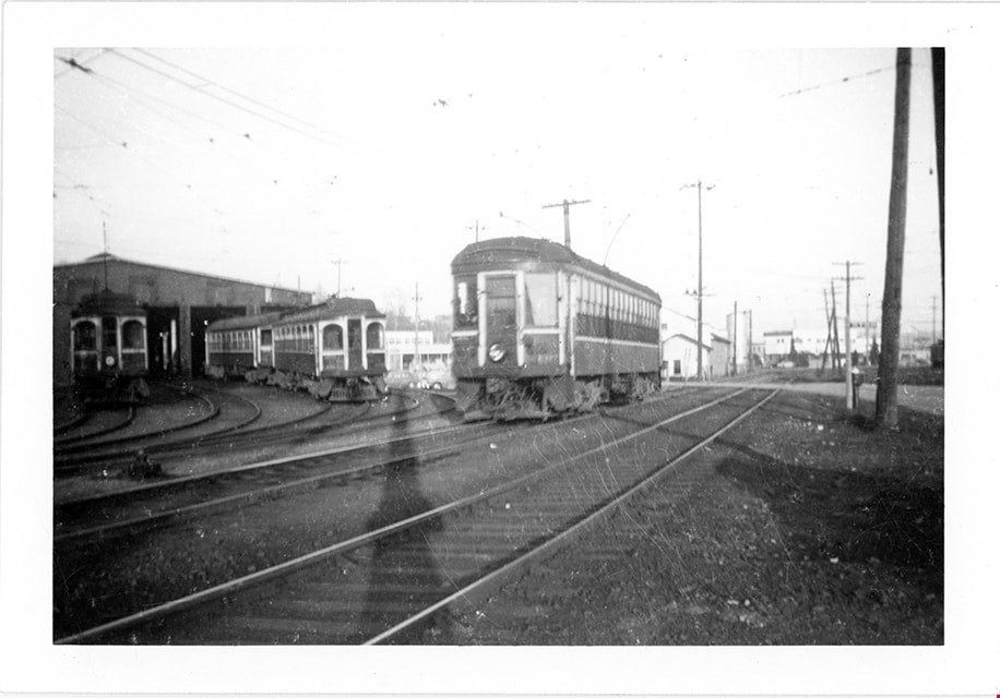
B.C. Electric Railway tram no. 1317 tram passing New Westminster barns
https://search.heritageburnaby.ca/link/museumdescription2898
- Repository
- Burnaby Village Museum
- Date
- 1952
- Collection/Fonds
- Burnaby Village Museum Photograph collection
- Description Level
- Item
- Physical Description
- 1 photograph : b&w ; 9 x 13 cm
- Scope and Content
- Photograph of B.C. Electric Railway tram no. 1317 tram on the main line passing New Westminster barns and heading westbound to Vancouver. Other trams are visible in the background.
- Repository
- Burnaby Village Museum
- Collection/Fonds
- Burnaby Village Museum Photograph collection
- Description Level
- Item
- Physical Description
- 1 photograph : b&w ; 9 x 13 cm
- Scope and Content
- Photograph of B.C. Electric Railway tram no. 1317 tram on the main line passing New Westminster barns and heading westbound to Vancouver. Other trams are visible in the background.
- Subjects
- Transportation - Electric Railroads
- Accession Code
- BV012.36.6
- Access Restriction
- No restrictions
- Reproduction Restriction
- No known restrictions
- Date
- 1952
- Media Type
- Photograph
- Scan Resolution
- 600
- Scan Date
- 2022-07-26
- Notes
- Title based on contents of photograph
- Typewritten text on verso of photograph reads: "BCER #1317 passing New Westminster / barns westbound to Vancouver in 1952"
Images