Narrow Results By
Subject
- Advertising Medium - Signs and Signboards
- Aerial Photographs
- Agricultural Tools and Equipment 1
- Agricultural Tools and Equipment - Cultivators 1
- Agricultural Tools and Equipment - Gardening Equipment 1
- Agriculture - Farms 8
- Agriculture - Fruit and Berries 1
- Agriculture - Poultry 1
- Animals - Birds 1
- Animals - Cats 2
- Animals - Cows 5
- Animals - Dogs 29
Person / Organization
- A. MacKenzie and Company Jubilee Store 2
- Burnaby Shoe Hospital 1
- Cascade Drive-In Theatre 1
- Cosco, N. 1
- Darlington Haskins Company 1
- Dunbar Hardwood Floor Limited 1
- E. Olsson and Sons Limited 1
- F. Fenk 1
- Hickman and Son Market 1
- Holmes and Wilson Trucking Company Limited 1
- L.J. McKinnon 1
- Maggs, Bill 1
![Aerial photograph of the Burnaby Village area, [1946] (date of original), copied 1991 thumbnail](/media/hpo/_Data/_Archives_Images/_Unrestricted/370/370-532.jpg?width=280)
Aerial photograph of the Burnaby Village area
https://search.heritageburnaby.ca/link/archivedescription37945
- Repository
- City of Burnaby Archives
- Date
- [1946] (date of original), copied 1991
- Collection/Fonds
- Burnaby Historical Society fonds
- Description Level
- Item
- Physical Description
- 1 photograph : b&w ; 3.5 x 4.4 cm print on contact sheet 20.5 x 26.7 cm
- Scope and Content
- Aerial photograph of the Sperling Avenue/Douglas Road Burnaby Village area.
- Repository
- City of Burnaby Archives
- Date
- [1946] (date of original), copied 1991
- Collection/Fonds
- Burnaby Historical Society fonds
- Subseries
- Burnaby Image Bank subseries
- Physical Description
- 1 photograph : b&w ; 3.5 x 4.4 cm print on contact sheet 20.5 x 26.7 cm
- Description Level
- Item
- Record No.
- 370-532
- Access Restriction
- No restrictions
- Reproduction Restriction
- No known restrictions
- Accession Number
- BHS1999-03
- Scope and Content
- Aerial photograph of the Sperling Avenue/Douglas Road Burnaby Village area.
- Subjects
- Aerial Photographs
- Media Type
- Photograph
- Notes
- Title based on contents of photograph
- 1 b&w copy negative accompanying
- Negative has a pink cast
- Geographic Access
- Douglas Road
- Sperling Avenue
- Canada Way
- Historic Neighbourhood
- Burnaby Lake (Historic Neighbourhood)
Images
![Aerial photograph of the Burnaby Village area, [1946] (date of original), copied 1991 thumbnail](/media/hpo/_Data/_Archives_Images/_Unrestricted/370/370-532.jpg)

Burnaby Lake rowing course dredging
https://search.heritageburnaby.ca/link/archivedescription38303
- Repository
- City of Burnaby Archives
- Date
- 1971
- Collection/Fonds
- Burnaby Historical Society fonds
- Description Level
- Item
- Physical Description
- 1 photograph : col. ; 12.5 x 18 cm
- Scope and Content
- Aerial photograph of the Burnaby Lake rowing course being dredged in 1971, in preparation for the 1973 Canada Summer Games.
- Repository
- City of Burnaby Archives
- Date
- 1971
- Collection/Fonds
- Burnaby Historical Society fonds
- Subseries
- Photographs subseries
- Physical Description
- 1 photograph : col. ; 12.5 x 18 cm
- Description Level
- Item
- Record No.
- 400-001
- Access Restriction
- No restrictions
- Reproduction Restriction
- Reproduce for fair dealing purposes only
- Accession Number
- BHS2007-04
- Scope and Content
- Aerial photograph of the Burnaby Lake rowing course being dredged in 1971, in preparation for the 1973 Canada Summer Games.
- Media Type
- Photograph
- Notes
- Title based on contents of photograph
- Geographic Access
- Roberts Street
- Burnaby Lake
- Street Address
- 6871 Roberts Street
- Historic Neighbourhood
- Burnaby Lake (Historic Neighbourhood)
- Planning Study Area
- Burnaby Lake Area
Images

![Burnaby Mountain, [between 1945 and 1949] (date of original), copied 1991 thumbnail](/media/hpo/_Data/_Archives_Images/_Unrestricted/370/370-798.jpg?width=280)
Burnaby Mountain
https://search.heritageburnaby.ca/link/archivedescription38211
- Repository
- City of Burnaby Archives
- Date
- [between 1945 and 1949] (date of original), copied 1991
- Collection/Fonds
- Burnaby Historical Society fonds
- Description Level
- Item
- Physical Description
- 1 photograph : b&w ; 3.1 x 5.0 cm print on contact sheet 20.5 x 26.8 cm
- Scope and Content
- Aerial photograph of Burnaby Mountain looking north.
- Repository
- City of Burnaby Archives
- Date
- [between 1945 and 1949] (date of original), copied 1991
- Collection/Fonds
- Burnaby Historical Society fonds
- Subseries
- Burnaby Image Bank subseries
- Physical Description
- 1 photograph : b&w ; 3.1 x 5.0 cm print on contact sheet 20.5 x 26.8 cm
- Description Level
- Item
- Record No.
- 370-798
- Access Restriction
- No restrictions
- Reproduction Restriction
- No known restrictions
- Accession Number
- BHS1999-03
- Scope and Content
- Aerial photograph of Burnaby Mountain looking north.
- Media Type
- Photograph
- Notes
- Title based on contents of photograph
- 1 b&w copy negative accompanying
- Geographic Access
- Burnaby Mountain Conservation Area
- Planning Study Area
- Burnaby Mountain Area
Images
![Burnaby Mountain, [between 1945 and 1949] (date of original), copied 1991 thumbnail](/media/hpo/_Data/_Archives_Images/_Unrestricted/370/370-798.jpg)

Burnaby Mountain Park and Centennial Pavilion
https://search.heritageburnaby.ca/link/archivedescription37408
- Repository
- City of Burnaby Archives
- Date
- 1970
- Collection/Fonds
- Burnaby Historical Society fonds
- Description Level
- Item
- Physical Description
- 1 photograph : col. postcard ; 9 x 14 cm
- Scope and Content
- Photographic postcard of the Burnaby Mountain Park sign a Centennial Pavilion. The caption on the back of the postcard reads: "The Centennial Pavilion was built in 1958 during British Columbia's Centenary. It is situated on Burnaby Mountain at an elevation of 1000 feet. Numerous footpaths througho…
- Repository
- City of Burnaby Archives
- Date
- 1970
- Collection/Fonds
- Burnaby Historical Society fonds
- Subseries
- Robert Prittie subseries
- Physical Description
- 1 photograph : col. postcard ; 9 x 14 cm
- Description Level
- Item
- Record No.
- 369-007
- Access Restriction
- No restrictions
- Reproduction Restriction
- Reproduce for fair dealing purposes only
- Accession Number
- BHS1999-01
- Scope and Content
- Photographic postcard of the Burnaby Mountain Park sign a Centennial Pavilion. The caption on the back of the postcard reads: "The Centennial Pavilion was built in 1958 during British Columbia's Centenary. It is situated on Burnaby Mountain at an elevation of 1000 feet. Numerous footpaths throughout the beautifully landscaped grounds lead to interesting view points which provide magnificent scenery of Burrard Inlet, Coast Range Mountains, City of Vancouver, and other surrounding Municipalities."
- Subjects
- Symbols - Flags
- Documentary Artifacts - Postcards
- Buildings - Recreational
- Advertising Medium - Signs and Signboards
- Media Type
- Photograph
- Photographer
- George Allen Aerial Photos Limited
- Notes
- Title based on caption
- Geographic Access
- Burnaby Mountain Conservation Area
- Centennial Way
- Street Address
- 100 Centennial Way
- Planning Study Area
- Burnaby Mountain Area
Images

![Cascade Drive-In Theatre, [1949] (date of original), copied 1991 thumbnail](/media/hpo/_Data/_Archives_Images/_Unrestricted/370/370-468.jpg?width=280)
Cascade Drive-In Theatre
https://search.heritageburnaby.ca/link/archivedescription37880
- Repository
- City of Burnaby Archives
- Date
- [1949] (date of original), copied 1991
- Collection/Fonds
- Burnaby Historical Society fonds
- Description Level
- Item
- Physical Description
- 1 photograph : b&w ; 3.0 x 4.4 cm print on contact sheet 20.1 x 26.7 cm
- Scope and Content
- Photograph of the Cascade Drive-In Theatre at 4050 Grandview Highway.
- Repository
- City of Burnaby Archives
- Date
- [1949] (date of original), copied 1991
- Collection/Fonds
- Burnaby Historical Society fonds
- Subseries
- Burnaby Image Bank subseries
- Physical Description
- 1 photograph : b&w ; 3.0 x 4.4 cm print on contact sheet 20.1 x 26.7 cm
- Description Level
- Item
- Record No.
- 370-468
- Access Restriction
- No restrictions
- Reproduction Restriction
- Reproduce for fair dealing purposes only
- Accession Number
- BHS1999-03
- Scope and Content
- Photograph of the Cascade Drive-In Theatre at 4050 Grandview Highway.
- Names
- Cascade Drive-In Theatre
- Media Type
- Photograph
- Photographer
- Van Dyke Studios
- Notes
- Title based on contents of photograph
- 1 b&w copy negative accompanying
- Negative has a pink cast
- Geographic Access
- Grandview Highway
- Street Address
- 4050 Grandview Highway
- Historic Neighbourhood
- Broadview (Historic Neighbourhood)
- Planning Study Area
- West Central Valley Area
Images
![Cascade Drive-In Theatre, [1949] (date of original), copied 1991 thumbnail](/media/hpo/_Data/_Archives_Images/_Unrestricted/370/370-468.jpg)

Contractors
https://search.heritageburnaby.ca/link/archivedescription34150
- Repository
- City of Burnaby Archives
- Date
- April 20, 1947
- Collection/Fonds
- Burnaby Historical Society fonds
- Description Level
- Item
- Physical Description
- 1 photograph : b&w negative ; 6.8 x 11.4 cm
- Scope and Content
- Photograph of a sign indexing contractors and their phone numbers. The top of the sign reads: "Whitsell Construction Co. Ltd., General Contractors, Glen. 1434-1435." Others contractors listed are: Clearing and excavating: Holmes & Wilson, BA.0098; Concrete: J. Marcovitch; Brickwork: Selkirk Sadler…
- Repository
- City of Burnaby Archives
- Date
- April 20, 1947
- Collection/Fonds
- Burnaby Historical Society fonds
- Subseries
- Alfred Bingham subseries
- Physical Description
- 1 photograph : b&w negative ; 6.8 x 11.4 cm
- Description Level
- Item
- Record No.
- 010-067
- Access Restriction
- No restrictions
- Reproduction Restriction
- No known restrictions
- Accession Number
- BHS2007-04
- Scope and Content
- Photograph of a sign indexing contractors and their phone numbers. The top of the sign reads: "Whitsell Construction Co. Ltd., General Contractors, Glen. 1434-1435." Others contractors listed are: Clearing and excavating: Holmes & Wilson, BA.0098; Concrete: J. Marcovitch; Brickwork: Selkirk Sadler & Son, KE.1458; Electrical: L.J. McKinnon, PA.2471; Millwork: R.F. Tait Woodworkers, BA.6491; Painting: E. Olsson & Sons Ltd., GL.1434; Plumbing: F. Fenk, DE.3071; Plastering: Turner Bros., FA.2572-4982R; Roofing and strapping: Ray Shaw, FR.4720; Floors: Dunbar Hardwood Floor Ltd., KE.3646; Septic tanks: N. Cosco, BA.4987; Tiling: Darlington Haskins Co. 1943 Ltd., BA.4829. This is part of the Willingdon Heights subdivision site.
- Names
- Darlington Haskins Company
- Dunbar Hardwood Floor Limited
- E. Olsson and Sons Limited
- F. Fenk
- Holmes and Wilson Trucking Company Limited
- L.J. McKinnon
- Cosco, N.
- Ray Shaw
- R.F. Tait Woodworkers
- Selkirk Sadler and Son
- Turner Brothers
- Whitsell Construction Company Limited
- Marcovitch, J.
- Media Type
- Photograph
- Photographer
- Bingham, Alfred "Alf"
- Notes
- Title based on contents of photograph
Images

![Deer Lake and Sperling Avenue, [1946] (date of original), copied 1991 thumbnail](/media/hpo/_Data/_Archives_Images/_Unrestricted/370/370-533.jpg?width=280)
Deer Lake and Sperling Avenue
https://search.heritageburnaby.ca/link/archivedescription37946
- Repository
- City of Burnaby Archives
- Date
- [1946] (date of original), copied 1991
- Collection/Fonds
- Burnaby Historical Society fonds
- Description Level
- Item
- Physical Description
- 1 photograph : b&w ; 3.5 x 4.4 cm print on contact sheet 20.5 x 26.7 cm
- Scope and Content
- Aerial photograph of Deer Lake and the Sperling Avenue area facing north.
- Repository
- City of Burnaby Archives
- Date
- [1946] (date of original), copied 1991
- Collection/Fonds
- Burnaby Historical Society fonds
- Subseries
- Burnaby Image Bank subseries
- Physical Description
- 1 photograph : b&w ; 3.5 x 4.4 cm print on contact sheet 20.5 x 26.7 cm
- Description Level
- Item
- Record No.
- 370-533
- Access Restriction
- No restrictions
- Reproduction Restriction
- No known restrictions
- Accession Number
- BHS1999-03
- Scope and Content
- Aerial photograph of Deer Lake and the Sperling Avenue area facing north.
- Media Type
- Photograph
- Notes
- Title based on contents of photograph
- 1 b&w copy negative accompanying
- Negative has a pink cast
- Geographic Access
- Deer Lake
- Sperling Avenue
- Historic Neighbourhood
- Burnaby Lake (Historic Neighbourhood)
- Planning Study Area
- Morley-Buckingham Area
Images
![Deer Lake and Sperling Avenue, [1946] (date of original), copied 1991 thumbnail](/media/hpo/_Data/_Archives_Images/_Unrestricted/370/370-533.jpg)
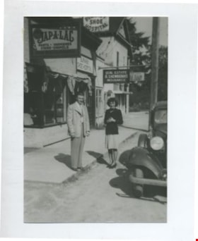
Edna and Bill Maggs
https://search.heritageburnaby.ca/link/archivedescription37082
- Repository
- City of Burnaby Archives
- Date
- 1942 (date of original), copied 1992
- Collection/Fonds
- Burnaby Historical Society fonds
- Description Level
- Item
- Physical Description
- 1 photograph : b&w ; 8.8 x 12.6 cm print
- Scope and Content
- Photograph of husband and wife, Bill and Edna Maggs, beside the Burnaby Shoe Hospital and Mr. Shewbrook's insurance office shortly after their wedding.
- Repository
- City of Burnaby Archives
- Date
- 1942 (date of original), copied 1992
- Collection/Fonds
- Burnaby Historical Society fonds
- Subseries
- Burnaby Centennial Anthology subseries
- Physical Description
- 1 photograph : b&w ; 8.8 x 12.6 cm print
- Description Level
- Item
- Record No.
- 315-545
- Access Restriction
- No restrictions
- Reproduction Restriction
- No known restrictions
- Accession Number
- BHS1994-04
- Scope and Content
- Photograph of husband and wife, Bill and Edna Maggs, beside the Burnaby Shoe Hospital and Mr. Shewbrook's insurance office shortly after their wedding.
- Names
- Maggs, Bill
- Trehearne, Edna Jean Mayhew Maggs
- Burnaby Shoe Hospital
- Shewbrooks Real Estate and Insurance
- Media Type
- Photograph
- Notes
- Title based on contents of photograph
- Geographic Access
- Kingsway
- Street Address
- 4539 Kingsway
- Historic Neighbourhood
- Central Park (Historic Neighbourhood)
- Planning Study Area
- Marlborough Area
Images

![Hickman Family Store, [1940] (date of original), copied 1986 thumbnail](/media/hpo/_Data/_Archives_Images/_Unrestricted/204/204-243.jpg?width=280)
Hickman Family Store
https://search.heritageburnaby.ca/link/archivedescription35386
- Repository
- City of Burnaby Archives
- Date
- [1940] (date of original), copied 1986
- Collection/Fonds
- Burnaby Historical Society fonds
- Description Level
- Item
- Physical Description
- 1 photograph : b&w ; 12.7 x 17.8 cm print
- Scope and Content
- Photograph of the exterior of Hickmans Market. This store was owned and operated by Alf Hickman and was located on Patterson Avenue (later numbered 5932 Patterson Avenue).
- Repository
- City of Burnaby Archives
- Date
- [1940] (date of original), copied 1986
- Collection/Fonds
- Burnaby Historical Society fonds
- Subseries
- Pioneer Tales subseries
- Physical Description
- 1 photograph : b&w ; 12.7 x 17.8 cm print
- Description Level
- Item
- Record No.
- 204-243
- Access Restriction
- No restrictions
- Reproduction Restriction
- No known restrictions
- Accession Number
- BHS1988-03
- Scope and Content
- Photograph of the exterior of Hickmans Market. This store was owned and operated by Alf Hickman and was located on Patterson Avenue (later numbered 5932 Patterson Avenue).
- Names
- Hickman and Son Market
- Media Type
- Photograph
- Notes
- Title based on contents of photograph
- Geographic Access
- Patterson Avenue
- Street Address
- 5932 Patterson Avenue
- Historic Neighbourhood
- Central Park (Historic Neighbourhood)
- Planning Study Area
- Maywood Area
Images
![Hickman Family Store, [1940] (date of original), copied 1986 thumbnail](/media/hpo/_Data/_Archives_Images/_Unrestricted/204/204-243.jpg)

Matheson and Sons Market
https://search.heritageburnaby.ca/link/archivedescription35041
- Repository
- City of Burnaby Archives
- Date
- 1949 (date of original), copied 1986
- Collection/Fonds
- Burnaby Historical Society fonds
- Description Level
- Item
- Physical Description
- 1 photograph : col. ; 8.6 x 12.7 cm print
- Scope and Content
- Photograph of the exterior of A. Matheson and Sons Market at 3576 Kingsway (later renumbered 4920 Kingsway) and Nelson Avenue. Signs on the building read, "A. Matheson & Sons Market," "Fresh Meats - Groceries," "Quality and Service," "Dexter 1372 1373," and "Free Delivery." Signs advertising pric…
- Repository
- City of Burnaby Archives
- Date
- 1949 (date of original), copied 1986
- Collection/Fonds
- Burnaby Historical Society fonds
- Subseries
- Chamberlain family subseries
- Physical Description
- 1 photograph : col. ; 8.6 x 12.7 cm print
- Description Level
- Item
- Record No.
- 179-012
- Access Restriction
- No restrictions
- Reproduction Restriction
- Reproduce for fair dealing purposes only
- Accession Number
- BHS1986-27
- Scope and Content
- Photograph of the exterior of A. Matheson and Sons Market at 3576 Kingsway (later renumbered 4920 Kingsway) and Nelson Avenue. Signs on the building read, "A. Matheson & Sons Market," "Fresh Meats - Groceries," "Quality and Service," "Dexter 1372 1373," and "Free Delivery." Signs advertising prices are outside the store. A sign by the street lights reads, "Signals set for 29 mph." Cars can be seen. This store was previously owned and operated by Alexander MacKenzie.
- Media Type
- Photograph
- Notes
- Title based on contents of photograph
- Print made from col. slide
- Geographic Access
- Kingsway
- Street Address
- 4920 Kingsway
- Historic Neighbourhood
- Central Park (Historic Neighbourhood)
- Planning Study Area
- Marlborough Area
Images


Matheson and Sons Market
https://search.heritageburnaby.ca/link/archivedescription35042
- Repository
- City of Burnaby Archives
- Date
- 1949 (date of original), copied 1986
- Collection/Fonds
- Burnaby Historical Society fonds
- Description Level
- Item
- Physical Description
- 1 photograph : col. ; 8.8 x 12.6 cm print
- Scope and Content
- Photograph of the exterior of A. Matheson and Sons Market at 3576 Kingsway (later renumbered 4920 Kingsway) and Nelson Avenue. Signs on the building read, "A. Matheson & Sons Market," "Fresh Meats - Groceries," "Quality and Service," "Dexter 1372 1373," and "Free Delivery." Signs advertising pric…
- Repository
- City of Burnaby Archives
- Date
- 1949 (date of original), copied 1986
- Collection/Fonds
- Burnaby Historical Society fonds
- Subseries
- Chamberlain family subseries
- Physical Description
- 1 photograph : col. ; 8.8 x 12.6 cm print
- Description Level
- Item
- Record No.
- 179-013
- Access Restriction
- No restrictions
- Reproduction Restriction
- Reproduce for fair dealing purposes only
- Accession Number
- BHS1986-27
- Scope and Content
- Photograph of the exterior of A. Matheson and Sons Market at 3576 Kingsway (later renumbered 4920 Kingsway) and Nelson Avenue. Signs on the building read, "A. Matheson & Sons Market," "Fresh Meats - Groceries," "Quality and Service," "Dexter 1372 1373," and "Free Delivery." Signs advertising prices are outside the store. A sign by the street lights reads, "Signals set for 29 mph." This store was previously owned and operated by Alexander MacKenzie.
- Media Type
- Photograph
- Notes
- Title based on contents of photograph
- Print made from col. slide
- Geographic Access
- Kingsway
- Street Address
- 4920 Kingsway
- Historic Neighbourhood
- Central Park (Historic Neighbourhood)
- Planning Study Area
- Marlborough Area
Images

![North Burnaby, [1946] thumbnail](/media/hpo/_Data/_Archives_Images/_Unrestricted/001/069-001.jpg?width=280)
North Burnaby
https://search.heritageburnaby.ca/link/archivedescription34633
- Repository
- City of Burnaby Archives
- Date
- [1946]
- Collection/Fonds
- Burnaby Historical Society fonds
- Description Level
- Item
- Physical Description
- 1 photograph : b&w ; 13.2 x 24.4 cm
- Scope and Content
- Aerial photograph of North Burnaby.
- Repository
- City of Burnaby Archives
- Date
- [1946]
- Collection/Fonds
- Burnaby Historical Society fonds
- Subseries
- Photographs subseries
- Physical Description
- 1 photograph : b&w ; 13.2 x 24.4 cm
- Description Level
- Item
- Record No.
- 069-001
- Access Restriction
- No restrictions
- Reproduction Restriction
- No known restrictions
- Accession Number
- BHS2007-04
- Scope and Content
- Aerial photograph of North Burnaby.
- Media Type
- Photograph
- Notes
- Title based on contents of photograph
- Historic Neighbourhood
- Vancouver Heights (Historic Neighbourhood)
- Capitol Hill (Historic Neighbourhood)
- Broadview (Historic Neighbourhood)
- Planning Study Area
- Burnaby Heights Area
- Willingdon Heights Area
- West Central Valley Area
- Capitol Hill Area
Images
![North Burnaby, [1946] thumbnail](/media/hpo/_Data/_Archives_Images/_Unrestricted/001/069-001.jpg)

Simon Fraser University
https://search.heritageburnaby.ca/link/archivedescription37404
- Repository
- City of Burnaby Archives
- Date
- 1970
- Collection/Fonds
- Burnaby Historical Society fonds
- Description Level
- Item
- Physical Description
- 1 photograph : col. postcard ; 9 x 14 cm
- Scope and Content
- Aerial photographic postcard of Simon Fraser University and Burnaby Mountain.
- Repository
- City of Burnaby Archives
- Date
- 1970
- Collection/Fonds
- Burnaby Historical Society fonds
- Subseries
- Robert Prittie subseries
- Physical Description
- 1 photograph : col. postcard ; 9 x 14 cm
- Description Level
- Item
- Record No.
- 369-003
- Access Restriction
- No restrictions
- Reproduction Restriction
- Reproduce for fair dealing purposes only
- Accession Number
- BHS1999-01
- Scope and Content
- Aerial photographic postcard of Simon Fraser University and Burnaby Mountain.
- Subjects
- Buildings - Schools - Universities and Colleges
- Aerial Photographs
- Documentary Artifacts - Postcards
- Names
- Simon Fraser University
- Media Type
- Photograph
- Photographer
- Thompson, Fred
- Notes
- Title based on contents of photograph.
- Geographic Access
- University Drive
- Street Address
- 8888 University Drive
- Planning Study Area
- Burnaby Mountain Area
Images


Simon Fraser University
https://search.heritageburnaby.ca/link/archivedescription37405
- Repository
- City of Burnaby Archives
- Date
- 1970
- Collection/Fonds
- Burnaby Historical Society fonds
- Description Level
- Item
- Physical Description
- 1 photograph : col. postcard ; 9 x 14 cm
- Scope and Content
- Aerial photographic postcard taken looking west over the parking lot and the Academic Quadrangle at Simon Fraser University.
- Repository
- City of Burnaby Archives
- Date
- 1970
- Collection/Fonds
- Burnaby Historical Society fonds
- Subseries
- Robert Prittie subseries
- Physical Description
- 1 photograph : col. postcard ; 9 x 14 cm
- Description Level
- Item
- Record No.
- 369-004
- Access Restriction
- No restrictions
- Reproduction Restriction
- Reproduce for fair dealing purposes only
- Accession Number
- BHS1999-01
- Scope and Content
- Aerial photographic postcard taken looking west over the parking lot and the Academic Quadrangle at Simon Fraser University.
- Subjects
- Aerial Photographs
- Buildings - Schools - Universities and Colleges
- Documentary Artifacts - Postcards
- Names
- Simon Fraser University
- Media Type
- Photograph
- Photographer
- Hildred, Chris
- Notes
- Title based on caption
- Geographic Access
- University Drive
- Street Address
- 8888 University Drive
- Planning Study Area
- Burnaby Mountain Area
Images


Simon Fraser University Buildings
https://search.heritageburnaby.ca/link/archivedescription37406
- Repository
- City of Burnaby Archives
- Date
- 1970
- Collection/Fonds
- Burnaby Historical Society fonds
- Description Level
- Item
- Physical Description
- 1 photograph : col. postcard ; 9 x 14 cm
- Scope and Content
- Photographic postcard taken looking north towards Simon Fraser University. The caption on the back of the postcard reads: "The aerial view shows part of the university buildings on Burnaby Mountain, with Burrard Inlet, Indian Arm and the North Shore Mountains in the background."
- Repository
- City of Burnaby Archives
- Date
- 1970
- Collection/Fonds
- Burnaby Historical Society fonds
- Subseries
- Robert Prittie subseries
- Physical Description
- 1 photograph : col. postcard ; 9 x 14 cm
- Description Level
- Item
- Record No.
- 369-005
- Access Restriction
- No restrictions
- Reproduction Restriction
- Reproduce for fair dealing purposes only
- Accession Number
- BHS1999-01
- Scope and Content
- Photographic postcard taken looking north towards Simon Fraser University. The caption on the back of the postcard reads: "The aerial view shows part of the university buildings on Burnaby Mountain, with Burrard Inlet, Indian Arm and the North Shore Mountains in the background."
- Subjects
- Aerial Photographs
- Buildings - Schools - Universities and Colleges
- Geographic Features - Mountains
- Documentary Artifacts - Postcards
- Names
- Simon Fraser University
- Media Type
- Photograph
- Notes
- Title based on caption
- Geographic Access
- University Drive
- Street Address
- 8888 University Drive
- Planning Study Area
- Burnaby Mountain Area
Images


Vancouver Building Maintenance
https://search.heritageburnaby.ca/link/archivedescription34583
- Repository
- City of Burnaby Archives
- Date
- 1975
- Collection/Fonds
- Burnaby Historical Society fonds
- Description Level
- Item
- Physical Description
- 1 photograph : b&w ; 20.5 x 25.2 cm
- Scope and Content
- Photograph of the former Royal Oak Hotel at Kingsway and Royal Oak Avenue, 3501 Kingsway (renumbered the 5000 block of Kingsway). Vancouver Building Maintenance business signs say, "Commercial / Industrial" and "Complete Janitor Service." A car is parked in front.
- Repository
- City of Burnaby Archives
- Date
- 1975
- Collection/Fonds
- Burnaby Historical Society fonds
- Subseries
- Photographs subseries
- Physical Description
- 1 photograph : b&w ; 20.5 x 25.2 cm
- Description Level
- Item
- Record No.
- 058-001
- Access Restriction
- No restrictions
- Reproduction Restriction
- Reproduce for fair dealing purposes only
- Accession Number
- BHS2007-04
- Scope and Content
- Photograph of the former Royal Oak Hotel at Kingsway and Royal Oak Avenue, 3501 Kingsway (renumbered the 5000 block of Kingsway). Vancouver Building Maintenance business signs say, "Commercial / Industrial" and "Complete Janitor Service." A car is parked in front.
- Media Type
- Photograph
- Notes
- Title based on contents of photograph
- Geographic Access
- Royal Oak Avenue
- Kingsway
- Historic Neighbourhood
- Central Park (Historic Neighbourhood)
- Planning Study Area
- Marlborough Area
Images
