More like 'Album page'
Narrow Results By
![Survey and Subdivision plans in New Westminster District Group 1 & Group 2 - Port Moody, Surrey
, [1898-1910] thumbnail](/media/hpo/_Data/_BVM_Cartographic_Material/1977/1977_0093_0073_001.jpg?width=280)
Survey and Subdivision plans in New Westminster District Group 1 & Group 2 - Port Moody, Surrey
https://search.heritageburnaby.ca/link/museumdescription7042
- Repository
- Burnaby Village Museum
- Date
- [1898-1910]
- Collection/Fonds
- Burnaby Village Museum Map collection
- Description Level
- File
- Physical Description
- 10 plans : graphite and ink on paper and linen; various sizes mounted on 2 sides of cardboard 76 x 102 cm
- Scope and Content
- File consists of a large board with four plans in New Westminster District mounted on one side and six plans mounted on the other side. Side A: 1. Plan : black ink and graphite on paper ; 46.5 x 37.5 cm. Title reads: "Bon Accord Hatchery / Sec 6 B5N R1W". Signed by Albert J. Hill P.L.S. August 1…
- Repository
- Burnaby Village Museum
- Collection/Fonds
- Burnaby Village Museum Map collection
- Description Level
- File
- Physical Description
- 10 plans : graphite and ink on paper and linen; various sizes mounted on 2 sides of cardboard 76 x 102 cm
- Material Details
- Scales vary (One chain equals 792 inches)
- Indexed number on tape on edge of board reads "73"
- Scope and Content
- File consists of a large board with four plans in New Westminster District mounted on one side and six plans mounted on the other side. Side A: 1. Plan : black ink and graphite on paper ; 46.5 x 37.5 cm. Title reads: "Bon Accord Hatchery / Sec 6 B5N R1W". Signed by Albert J. Hill P.L.S. August 12, 1903. Plan covers land identified as Section 6, Section 7, Located along the south shore of the Fraser River in Port Mann (Geographic location: Surrey). 2. Plan : black ink and graphite on paper ; 36 x 31 cm. Title reads: "Survey of Portions of Sec. 20 B5N R2W". Plan is stamped in red ink: "Albert J. Hill, Civil Engineer". Scale 4 chains = 1 inch. 3. Plan : black ink on linen ; 14 x 23 cm. Title reads:"Port Moody". Plan covers sections in Lot 191 (District Lot 191) bordered by Burrard Inlet to the west and Lot 235 and Lot 233 to the south. Streets identified include Water Street, Beauregard Street, Yonge Street, Clinton Street and Oxford Street. 4. Plan: graphite and ink on paper ; 43.5 x 64.5 cm. Title reads: "Sketch Plan Approved by Council [sic] / _[sic]1898". (No identifying geographic landmarks provided) Side B: 1. Plan : graphite on paper ; 53.5 x 31 cm. Title reads: "Plan of Lot 13, Gr. II, N.W. Dist". Sketch plan covers area along the Fraser River in District Lot 13, New Westminster District, Group 2. District Lot 13 is bordered by District Lot 14 (to the west) and Lot 12 (to the east). Natural geographic features within District Lot 13 are noted as "dense brush and fallen timber / sallal / rough spruce and cedar / swamp / fine alder / sallal / fine alder bottom land / fine brook". Scale: 3 chains = 1 inch (Geographic location: Surrey) 2. Plan : black ink on paper ; 50.5 x 34.5 cm. Title reads: "Indian Reserve / Opposite / New Westminster". Plan covers area on the south shore of the Fraser River in New Westminster District Group 2 in an area known as Brownsville. Lots are identified as District Lots 1, 2, 3, 4, 18, 17 and 8 and Sections A and B. Two areas of land are noted as "Indian Reserve"; one 6.3 acre parcel and one 104.25 acre parcel, both within District Lot 1. Note on plan reads: "N.B. this plan shows reserves and adjacent properties as they are on the ground". (Geographic location: Surrey) 3. Plan : black and col. ink on paper ; 19.5 x 31.5 cm. Title reads: "Bon Accord Road". Plan shows elevation. "Average section 10 feet = 1 inch". Plan is stamped in red ink: "Albert J. Hill, Civil Engineer and Provincial Land Surveyor, New Westminster, B.C." (Geographic location: Surrey) 4. Plan : black and col. ink on linen ; 16.5 x 25.5 cm. (no formal title) Plan covers area of Section 35, south of Yale Wagon Road and east of Quible Road. Plan is signed by "Albert J. Hill / B.C.L.S." (Geographic location: Surrey) 5. Plan: black and col. ink on linen ; 22.5 x 22.5 cm. (no formal title) Plan covers area between Yale Road and Townline Road in Surrey. Scale: 4 chains = 1 inch. Plan is signed by Albert J. Hill B.C.L.S. [190-] (Geographic location: Surrey) 6. Plan : graphite on paper ; 24 x 54 cm. (no formal title) Plan covers sectioned areas along Bon Accord Road. Sections are identified as " Sec. 8 / T.F. Patterson"; "Sec. 9 / Russell"; "Elliott_Burnett_Crean / Sec. 16"; "Dom. Govt. / Sec. 17". (Geographic location: Surrey, beneath the Port Mann bridge)
- Names
- ʷməθkʷəy̓əm (Musqueam)
- Accession Code
- HV977.93.73
- Access Restriction
- No restrictions
- Reproduction Restriction
- No known restrictions
- Date
- [1898-1910]
- Media Type
- Cartographic Material
- Scan Resolution
- 600
- Scan Date
- 2023-06-26
- Notes
- Title based on contents of file
- Note re plan 2B: The sight of Brownsville was also the former site of the Qayqayt First Nation and one of the main summer villages of the Kwantlen and ʷməθkʷəy̓əm (Musqueam) peoples
Zoomable Images
![Survey and Subdivision plans in New Westminster District Group 1 & Group 2 - Port Moody, Surrey
, [1898-1910] thumbnail](/media/hpo/_Data/_BVM_Cartographic_Material/1977/1977_0093_0073_003_seadragon/1977_0093_0073_003.jpg?w=280)
Survey and Subdivision plans in New Westminster District Group 1 & Group 2 - Port Moody, Surrey , [1898-1910]
Zoom into Image
![Survey and Subdivision plans in New Westminster District Group 2 - Surrey, Delta
, [1898-1910] thumbnail](/media/hpo/_Data/_BVM_Cartographic_Material/1977/1977_0093_0078_001.jpg?width=280)
Survey and Subdivision plans in New Westminster District Group 2 - Surrey, Delta
https://search.heritageburnaby.ca/link/museumdescription7047
- Repository
- Burnaby Village Museum
- Date
- [1898-1910]
- Collection/Fonds
- Burnaby Village Museum Map collection
- Description Level
- File
- Physical Description
- 10 plans : graphite and ink on paper and linen; various sizes mounted on 2 sides of cardboard 76 x 102 cm
- Scope and Content
- File consists of a large board with four plans in New Westminster District mounted on one side and six plans mounted on the other side. Side A: 1. Plan : black ink on paper with colour (no formal title). Plan covers area in New Westminster District, Group 2 situated along the south shore of the …
- Repository
- Burnaby Village Museum
- Collection/Fonds
- Burnaby Village Museum Map collection
- Description Level
- File
- Physical Description
- 10 plans : graphite and ink on paper and linen; various sizes mounted on 2 sides of cardboard 76 x 102 cm
- Material Details
- Scales vary
- Indexed number on tape on edge of board reads "78"
- Scope and Content
- File consists of a large board with four plans in New Westminster District mounted on one side and six plans mounted on the other side. Side A: 1. Plan : black ink on paper with colour (no formal title). Plan covers area in New Westminster District, Group 2 situated along the south shore of the Fraser River identified as "Indian Reserve / Turner 1868" situated in District Lot 1 between District Lot 2 identified as "Mohun's Line" and "Herring's Line" bordered by lots B and A. Includes note "see plan of subdivision of Lots 3 & 4 Gr. 2". (Geographic location: Surrey) 2. Plan : graphite on paper ; Title reads: "B5N R2W, Sec.26_Sec. 28 / Sec. 35_Sec.36". Plan covers a 60 acre parcel in Sec. 35 with Yale wagon road to the south. Scale: 6 chains = 1 inch (Geographic location: Surrey) 3. Plan : black ink on paper ; Title reads: "Survey for Proposed Highway in Indian Reserve Surrey". Plan covers area of land to the northwest of Lot 2 along the shore of the Fraser River and identfies route of proposed highway, proposed tramway as well at the Great Northern Railway and bridge. Scale: 2 chains = 1 inch 4. Plan : black ink on red lined graphing paper ; Title reads: "Sketch Plan Showing Section of Great Northern R. of W. at Point of Crossing of Proposed Ditch". Plan covers area of Lot 2 in New Westminster District, Group 2. (Surrey) Scale: 1 inch = 5 feet. (Geographic location: Surrey) Side B: 1. Plan : black ink on paper ; Title reads: "Plan of Subdivision of a Portion of Section 13, TP2, Surrey Municipality, New Westminster District, B.C.". Plan covers land bordered by Coast Meridian Road (to the east), Bose Road (to the south) and Pike Road (to the west). Surveyed for D.S. Bayners, Nov. 24, 1908. Scale: 5 chains= 1 inch 2. Plan : black ink on linen with colour ; Title reads: "Traverse of the Waterline in front of Lots 3 and 4, Group 2, New Westminster District with G.N. Railway Right of Way". Plan covers area along the southern shore of the Fraser River with a road crossing the Great Northern Railway and leading to a wharf. Scale: 100 feet = 1 inch (Geographic location: Surrey) 3. Plan : black ink on paper ; Title reads: "Survey of the South Boundary of Sec. 12, Township 2, New Westminster District". Plan covers area south of Bose Road and west of Coast Meridean Road and north of McClellen Road. Scale: 400 feet = 1 inch. Sec.12 (Geographic location: Surrey) 4. Plan : graphite on paper ; Title reads: "Plan of Subdivisioin of a part of S.E. 1/4 of Sec. 7, TP 8". Plan covers area of Section 7 in New Westminster District, Group 2, Township 8. Streets are identified running through lot including, Langley Ave., Robinson Ave, Melrose Ave., Hawthorne Ave., Broadway, Bond Ave., Mable Ave., Breene Ave. and McLelland Ave. and Clover Valley Road. Scale: 200 feet = 1 inch. Note in black ink reads: See Bd. 166 for blue print. (Geographic location: Surrey) 5. Plan : graphite on linen ; Title reads: "Sec.20, B5N R2W". Plan covers area north of Yale Road and is subdivided into parts identified as A, B, C, D, E, and unknown. (Geographic location: Surrey) 6. Plan : black ink and graphite on paper ; (no formal title) Plan covers lots surveyed along Ladner Road identified as A, B and Lots 13, 12 and 11. [Geographic location: Delta]
- Accession Code
- HV977.93.78
- Access Restriction
- No restrictions
- Reproduction Restriction
- No known restrictions
- Date
- [1898-1910]
- Media Type
- Cartographic Material
- Scan Resolution
- 600
- Scan Date
- 2023-06-26
- Notes
- Title based on contents of file
- Note re plans 1A & 3A: The sight of Brownsville was also the former site of the Qayqayt First Nation and one of the main summer villages of the Kwantlen and ʷməθkʷəy̓əm (Musqueam) peoples
- Scale is measured in chains and feet. (One chain equals 792 inches)
Zoomable Images
![Survey and Subdivision plans in New Westminster District Group 2 - Surrey, Delta
, [1898-1910] thumbnail](/media/hpo/_Data/_BVM_Cartographic_Material/1977/1977_0093_0078_003_seadragon/1977_0093_0078_003.jpg?w=280)
Survey and Subdivision plans in New Westminster District Group 2 - Surrey, Delta , [1898-1910]
Zoom into Image
![Curtis Joe, [2001] thumbnail](/media/hpo/_Data/_Archives_Images/_Unrestricted/535/535-2974.jpg?width=280)
Curtis Joe
https://search.heritageburnaby.ca/link/archivedescription97699
- Repository
- City of Burnaby Archives
- Date
- [2001]
- Collection/Fonds
- Burnaby NewsLeader photograph collection
- Description Level
- Item
- Physical Description
- 1 photograph (tiff) : col.
- Scope and Content
- Photograph of Curtis Joe, a Powwow dancer from Shishalh (Sechelt), preparing to perform at the Arrows to Freedom Cultural Healing Society Powwow at Stride Community School.
- Repository
- City of Burnaby Archives
- Date
- [2001]
- Collection/Fonds
- Burnaby NewsLeader photograph collection
- Physical Description
- 1 photograph (tiff) : col.
- Description Level
- Item
- Record No.
- 535-2974
- Access Restriction
- No restrictions
- Reproduction Restriction
- No restrictions
- Accession Number
- 2018-12
- Scope and Content
- Photograph of Curtis Joe, a Powwow dancer from Shishalh (Sechelt), preparing to perform at the Arrows to Freedom Cultural Healing Society Powwow at Stride Community School.
- Names
- Stride Avenue School
- Media Type
- Photograph
- Photographer
- Bartel, Mario
- Notes
- Title based on caption
- Collected by editorial for use in a December 2001 issue of the Burnaby NewsLeader
- Caption from metadata: "Curtis Joe, a "fancy dancer" with the Salish nation in Sechelt, adjusts his costume prior to performing at the Arrows to Freedom Cultural Healing Society's traditional pow-wow at Stride Community School on Saturday."
- Geographic Access
- Stride Avenue
- Street Address
- 7014 Stride Avenue
- Historic Neighbourhood
- Edmonds (Historic Neighbourhood)
- Planning Study Area
- Stride Avenue Area
Images
![Curtis Joe, [2001] thumbnail](/media/hpo/_Data/_Archives_Images/_Unrestricted/535/535-2974.jpg)

Commercial Map of Greater Vancouver and District
https://search.heritageburnaby.ca/link/museumdescription9552
- Repository
- Burnaby Village Museum
- Date
- July 1921
- Collection/Fonds
- Burnaby Village Museum Map collection
- Description Level
- Item
- Physical Description
- 1 map : col. lithograph mounted on linen ; 107 x 138 cm
- Scope and Content
- Commercial map of Greater Vancouver and District. Map depicts district lots, railroads, electric railways, streets, street car stops, schools, buildings, postal block numbers, parks and First Nations reserves. Map covers the geographcial areas of Vancouver, Burnaby, New Westminster, portions of Ric…
- Repository
- Burnaby Village Museum
- Collection/Fonds
- Burnaby Village Museum Map collection
- Description Level
- Item
- Physical Description
- 1 map : col. lithograph mounted on linen ; 107 x 138 cm
- Material Details
- Includes Legend and Index
- Scope and Content
- Commercial map of Greater Vancouver and District. Map depicts district lots, railroads, electric railways, streets, street car stops, schools, buildings, postal block numbers, parks and First Nations reserves. Map covers the geographcial areas of Vancouver, Burnaby, New Westminster, portions of Richmond, West Vancouver, North Vancouver, and Surrey with half mile circles that radiate from Vancouver City Hall on the corner of Main and Hastings. Bottom of map includes an index of street names, along with their corresponding map grid locations. The map is bordered by Marine Drive to the west, North Road to the east, Dempsey Street to the north and 20th Road to the south.
- History
- Bought by donor at thrift store years ago. No known provenance.
- Publisher
- Produced by Photo - Lithography, Colonist , Victoria, B.C.
- Geographic Access
- Vancouver
- Accession Code
- BV018.24.1
- Access Restriction
- No restrictions
- Reproduction Restriction
- No known restrictions
- Date
- July 1921
- Media Type
- Cartographic Material
- Scan Resolution
- 300
- Scan Date
- 16-Jun-20
- Scale
- 100
- Notes
- Transcribed title
- Title on map reads: "COMMERCIAL MAP / OF / GREATER VANCOUVER / AND / DISTRICT / Compiled and Published by / The Vancouver Map & Blueprint Co. Ltd. / 441 Seymour St. Vancouver B.C. / July, 1921".
Images

![Interview with Josephine Chow by Denise Fong February 7, 2020, [1900-2020] (interview content), interviewed Feb. 7, 2020 thumbnail](/media/hpo/_Data/_BVM_Images/2017/2017_0036_0004_001.jpg?width=280)
Interview with Josephine Chow by Denise Fong February 7, 2020
https://search.heritageburnaby.ca/link/museumdescription12337
- Repository
- Burnaby Village Museum
- Date
- [1900-2020] (interview content), interviewed Feb. 7, 2020
- Collection/Fonds
- Burnaby Village Museum fonds
- Description Level
- Item
- Physical Description
- 1 sound recording (mp3) (00:43:19 min.)
- Scope and Content
- Recording consists of an interview with Josephine Chow (nee Hong) conducted by BVM researcher Denise Fong at the Burnaby Village Museum. Josephine describes her family history and recollects her childhood experiences in 1950s and 60s while growing with her family on their "Hop On" farm in Burnaby. …
- Repository
- Burnaby Village Museum
- Collection/Fonds
- Burnaby Village Museum fonds
- Series
- Museum Oral Histories series
- Subseries
- Chinese Canadians in Burnaby subseries
- Description Level
- Item
- Physical Description
- 1 sound recording (mp3) (00:43:19 min.)
- Material Details
- Interviewer: Denise Fong Interviewee: Josephine Chow Location of Interview: Burnaby Village Museum Interview Date: February 7, 2020 Total Number of Tracks: 1 Total Length of all Tracks: 00:43:19
- Scope and Content
- Recording consists of an interview with Josephine Chow (nee Hong) conducted by BVM researcher Denise Fong at the Burnaby Village Museum. Josephine describes her family history and recollects her childhood experiences in 1950s and 60s while growing with her family on their "Hop On" farm in Burnaby. The farm is situated in the Big Bend area along Marine Drive and is still in operation today. 0:00-08:45 Josephine Chow provides some historical background on the history of “Hop On Farm” and her family in British Columbia. She tells of how her grandfather Gay Tim Hong and three partners pooled money together to purchase twelve acres on Marine Drive in 1951. Prior to this, most of them farmed on the ʷməθkʷəy̓əm (Musqueam) First Nation Reserve for 20-30 years. It all began when her great grandfather Sui Wing Hong, first came to Canada from China and slowly brought over her grandfather, father and other members of the family. Her grandfather, Gay Tim Hong went back and forth between Canada and China at least four times since he and her grandmother had four children including her father, who was born in 1931. Her father came to Canada at 10 years of age to live with his father. Josephine’s great grandfather came to Vancouver from Zhongshan county in Canton Province (also known as Guangdong). 8:46- 14:20 Josephine provides the names of her siblings from the eldest to the youngest; Pauline, Josephine (herself), Catherine, Noreen, Gary, Darlene and Marlene. She describes what life was like on the farm with her parents working from sunrise to sunset. The family farmed vegetable produce taking orders from local stores in the lower mainland. Often the children helped their parents with the orders starting at eight or nine years of age. Other workers on the farm travelled by bus from Vancouver’s Chinatown. She also tells of how her father was an animal lover and raised chickens, pigeons, geese, koy, goldfish and dogs. 14: 21 – 16:56 Josephine describes what Burnaby was like during the time that she grew up in the late 1950s. She explains that Burnaby was very quiet with nothing being open on Sundays. On the farm, she and her siblings would entertain themselves by playing games like soccer, baseball and kick ball or also by catching frogs, snails, caterpillars and ladybugs. There were neighbours living on Marine Drive and almost every house had someone who we went to the same elementary school. The neighbourhood children would often come to play with them on their farm. 16:56- 26:47 Josephine describes how when they were young there were farms all around them and how on Sunday drives with her father, they would go to feed horses or look at the cows. Josephine shares that her elder sister Pauline was the only one born in China and how when she first arrived that she lived on the ʷməθkʷəy̓əm (Musqueam) First Nations Reserve with their parents before they moved to Burnaby. Josephine recollects that most of her friends were farmer’s kids from the neighbourhood but while in school, she had more Caucasian friends. Josephine and her siblings attended Glenwood Elementary on Marine Drive and later Junior Secondary at McPherson Park (grades 8-10) and Burnaby South Senior Secondary (grades 11-12. ). She shares some of her experiences while attending school. She said that there were about a dozen Asians in school with her, mostly from farming families in the “Flats”. 26:48- 30:45 Josephine describes what life was like for her and her siblings after school. They often helped on the farm when they got home, usually taking care of orders for green onions. Her mother made dinner and did all of the cooking for family and workers on the farm as well as working in the fields. Her father did all of the grocery shopping in Vancouver’s Chinatown two or three times per week where he purchased meat and fish. She says that her grandfather, often travelled by bus every Saturday or Sunday to meet up with friends in Chinatown. Extracurricular activities for her and her siblings included volley ball and soccer as long as it didn’t interfere with their work schedule on the farm. 30:46- 37:03 Josephine describes what occurred while living at home, the food they ate, shopping and attending Chinese school. Her mother cooked only Chinese food, she didn’t know how to cook “Western food”. For school lunches, the kids made their own sandwiches. She tells of a Chinese language school arranged by Mrs. Joe [sic] who lived on Gilley Road and was Canadian born Chinese. Mrs. Joe [sic] also arranged an English class for farmer’s wives on Tuesday nights in which her mother attended. Josephine recollects learning Mandarin from Mrs. Joe [sic] a few days a week after her regular school. Chinese school took place at Riverway School on Meadow Avenue in Burnaby. Mrs. Joe also taught them a lot about Chinese culture including Kung Fu, Chinese Dance and Chinese brush painting. 37:04- 39:39 Josephine describes Medical Care for her and her family in the 1950s and 1960s. She tells of a female Chinese doctor in Vancouver, Dr. Madeline Chung. Dr. Chung was responsible for delivering a lot of Chinese babies including Josephine. The family also visited herbalists in Vancouver Chinatown. They would often buy herbs for colds etc. Josephine also tells of how her parents stayed in touch with family in China by writing letters. Her mother’s family, including her parents and siblings were still in China while most of her father’s family were here in Canada. 39:40- 43:19 – In closing, Josephine shares how life is much busier now and of how she misses the quietness of her days growing up. She briefly describes her life on the family farm now and how different it is from when her parents worked the farm. She explains how farming methods have changed and how they don’t have to work as hard as her parents did.
- History
- Interviewee biography: Josephine Chow (nee Hong) is the second eldest child of Chan Kow Hong and Sui Ha Hong. In 1925, Josephine's grandfather, Gay Tim Hong immigrated to Canada from Zhongshan county in Canton Province (also known as Guangdong). In 1952, her father, Chan Kow Hong joined his father, Gay Tim Hong and by 1953, he established "Hop On Farms" in the Big Bend area of Burnaby near Marine Drive. Josephine grew up on the farm with her parents and six siblings; Pauline, Catherine, Norine, Gary, Darlene and Marlene. In 1969, Josephine's elder sister Pauline and her husband Jack Chan took over the family farm and in 1972 their father and grandfather moved to Kamloops to open a restaurant. As an adult, Josephine worked in several different areas including owning and running her own Aesthetics business. Josephine eventually retired and returned to the farm to assist her siblings. The farm is still in operation. Interviewer biography: Denise Fong is a historical researcher at Burnaby Village Museum. She has degrees in Anthropology (BA) and Archaeology (MA), and is completing her doctoral degree at UBC in Interdisciplinary Studies. Her primary research interests are in Chinese Canadian history and critical heritage studies. She is the co-curator of BVM’s “Across the Pacific” exhibition, and the Museum of Vancouver’s “A Seat at the Table – Chinese Immigration and British Columbia”.
- Creator
- Burnaby Village Museum
- Subjects
- Persons - Chinese Canadians
- Agriculture - Farms
- Education
- Buildings - Schools
- First Nations reserves - British Columbia
- Names
- Chow, Josephine
- Glenwood Elementary School
- McPherson Park Junior Secondary School
- ʷməθkʷəy̓əm (Musqueam)
- Responsibility
- Fong, Denise
- Geographic Access
- Byrne Road
- Accession Code
- BV020.6.1
- Access Restriction
- No restrictions
- Reproduction Restriction
- No known restrictions
- Date
- [1900-2020] (interview content), interviewed Feb. 7, 2020
- Media Type
- Sound Recording
- Historic Neighbourhood
- Fraser Arm (Historic Neighbourhood)
- Planning Study Area
- Big Bend Area
- Related Material
- See also BV017.36*
- Scan Resolution
- 600
- Scan Date
- 12/3/2017
- Scale
- 100
- Notes
- Title based on contents of interview
- Photograph info: Gary Hong and Chan Kow Hong harvesting celery at Hop-On Farms [1969]. BV017.36.4
Images
![Interview with Josephine Chow by Denise Fong February 7, 2020, [1900-2020] (interview content), interviewed Feb. 7, 2020 thumbnail](/media/hpo/_Data/_BVM_Images/2017/2017_0036_0004_001.jpg)
Audio Tracks
Interview with Josephine Chow by Denise Fong February 7, 2020, [1900-2020] (interview content), interviewed Feb. 7, 2020
Interview with Josephine Chow by Denise Fong February 7, 2020, [1900-2020] (interview content), interviewed Feb. 7, 2020
https://search.heritageburnaby.ca/media/hpo/_Data/_BVM_Sound_Recordings/Oral_Histories/2020_0006_0001_001.mp3![The Lions from Burnaby Park, [between 1926 and 1929] thumbnail](/media/hpo/_Data/_BVM_Images/1971/197202040003.jpg?width=280)
The Lions from Burnaby Park
https://search.heritageburnaby.ca/link/museumdescription3109
- Repository
- Burnaby Village Museum
- Date
- [between 1926 and 1929]
- Collection/Fonds
- Burnaby Village Museum Photograph collection
- Description Level
- Item
- Physical Description
- 1 photograph : b&w photogravure ; 14.5 x 9.5 cm
- Scope and Content
- Photograph of the north shore mountains, including the Lions, taken from Robert Burnaby Park.
- Repository
- Burnaby Village Museum
- Collection/Fonds
- Burnaby Village Museum Photograph collection
- Description Level
- Item
- Physical Description
- 1 photograph : b&w photogravure ; 14.5 x 9.5 cm
- Scope and Content
- Photograph of the north shore mountains, including the Lions, taken from Robert Burnaby Park.
- Geographic Access
- Wedgewood Street
- Robert Burnaby Park
- Street Address
- 8155 Wedgewood Street
- Accession Code
- HV972.204.3
- Access Restriction
- No restrictions
- Reproduction Restriction
- No known restrictions
- Date
- [between 1926 and 1929]
- Media Type
- Photograph
- Historic Neighbourhood
- Burnaby Lake (Historic Neighbourhood)
- Planning Study Area
- Lakeview-Mayfield Area
- Related Material
- For other photographs from the same album, see HV972.204.3 - .14
- Scan Resolution
- 600
- Scan Date
- 2023-04-25
- Photographer
- Lloyd, Frank Ernest
- Notes
- Annotations made in white paint on recto of photograph read: "'The Lions' from Burnaby Park" and "Lloyd Studio, McKay."
Images
![The Lions from Burnaby Park, [between 1926 and 1929] thumbnail](/media/hpo/_Data/_BVM_Images/1971/197202040003.jpg)

Butcher family
https://search.heritageburnaby.ca/link/archivedescription35685
- Repository
- City of Burnaby Archives
- Date
- 1920 (date of original), copied 1986
- Collection/Fonds
- Burnaby Historical Society fonds
- Description Level
- Item
- Physical Description
- 1 photograph : b&w ; 12.7 x 17.8 cm print
- Scope and Content
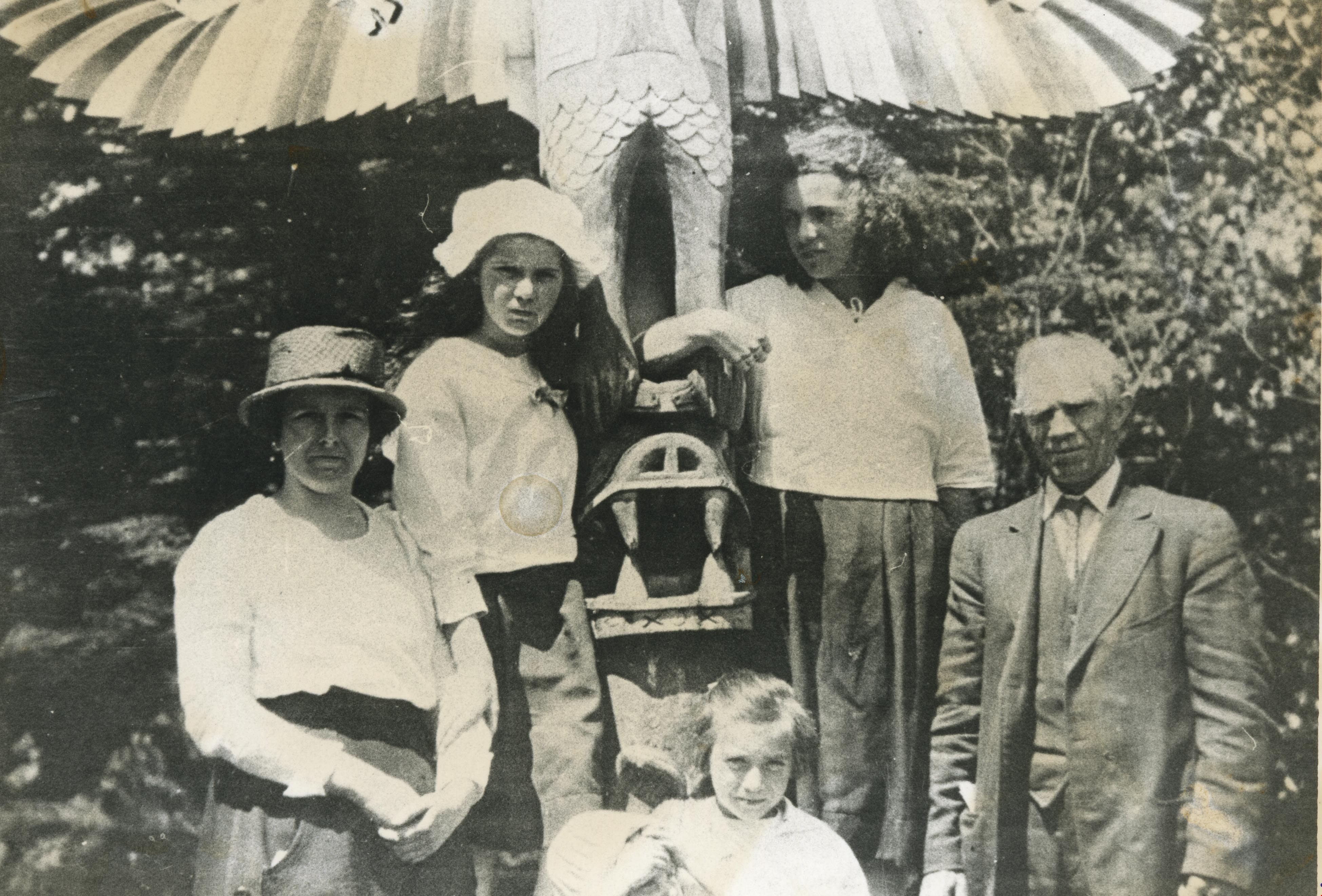
- Photograph of the Butcher family standing next to a totem pole. Back row, left to right: Florence Butcher (mother), Violet Butcher (sister), Thelma Butcher (sister), and Reuben Butcher (father). Front row: Dorothy Butcher (sister) and Patricia Butcher (baby sister).
- Repository
- City of Burnaby Archives
- Date
- 1920 (date of original), copied 1986
- Collection/Fonds
- Burnaby Historical Society fonds
- Subseries
- Pioneer Tales subseries
- Physical Description
- 1 photograph : b&w ; 12.7 x 17.8 cm print
- Description Level
- Item
- Record No.
- 204-543
- Access Restriction
- No restrictions
- Reproduction Restriction
- No known restrictions
- Accession Number
- BHS1988-03
- Scope and Content
- Photograph of the Butcher family standing next to a totem pole. Back row, left to right: Florence Butcher (mother), Violet Butcher (sister), Thelma Butcher (sister), and Reuben Butcher (father). Front row: Dorothy Butcher (sister) and Patricia Butcher (baby sister).
- Names
- Butcher, Dorothy
- Butcher, Florence
- Butcher, Patricia
- Butcher, Reuben
- Butcher, Thelma
- Lynds, Violet Butcher
- Media Type
- Photograph
- Notes
- Title based on contents of photograph
Images
![Bernice and Bert Whittaker, [2002] thumbnail](/media/hpo/_Data/_Archives_Images/_Unrestricted/535/535-2815.jpg?width=280)
Bernice and Bert Whittaker
https://search.heritageburnaby.ca/link/archivedescription97476
- Repository
- City of Burnaby Archives
- Date
- [2002]
- Collection/Fonds
- Burnaby NewsLeader photograph collection
- Description Level
- Item
- Physical Description
- 1 photograph (tiff) : col.
- Scope and Content
- Photograph of Bernice Whittaker kissing her husband, Bert Whittaker, on the cheek after the Royal Canadian Legion Branch 83 dedicated their auditorium to Bert, a longtime volunteer. The couple is standing in front of the Legion in south Burnaby.
- Repository
- City of Burnaby Archives
- Date
- [2002]
- Collection/Fonds
- Burnaby NewsLeader photograph collection
- Physical Description
- 1 photograph (tiff) : col.
- Description Level
- Item
- Record No.
- 535-2815
- Access Restriction
- No restrictions
- Reproduction Restriction
- No restrictions
- Accession Number
- 2018-12
- Scope and Content
- Photograph of Bernice Whittaker kissing her husband, Bert Whittaker, on the cheek after the Royal Canadian Legion Branch 83 dedicated their auditorium to Bert, a longtime volunteer. The couple is standing in front of the Legion in south Burnaby.
- Names
- Royal Canadian Legion
- Media Type
- Photograph
- Photographer
- Bartel, Mario
- Notes
- Title based on caption
- Collected by editorial for use in an October 2002 issue of the Burnaby NewsLeader
- Caption from metadata: "Bert Whittaker gets a congratulatory kiss from his wife of 58 years, Bernice, after the South Burnaby branch of the Royal Canadian Legion dedicated its auditorium to their longtime volunteer. The honor was part of the branch's 40th anniversary celebration, and came only two days after the Whittakers' wedding anniversary."
- Geographic Access
- Grimmer Street
- Street Address
- 5289 Grimmer Street
- Historic Neighbourhood
- Central Park (Historic Neighbourhood)
- Planning Study Area
- Windsor Area
Images
![Bernice and Bert Whittaker, [2002] thumbnail](/media/hpo/_Data/_Archives_Images/_Unrestricted/535/535-2815.jpg)
Brackman-Ker Milling Co. Jubilee Picnic at Bowen Island
https://search.heritageburnaby.ca/link/museumdescription2958
- Repository
- Burnaby Village Museum
- Date
- August 11, 1928
- Collection/Fonds
- Burnaby Village Museum Photograph collection
- Description Level
- Item
- Physical Description
- 1 photograph : sepia ; panorama 53 x 20.2 cm
- Scope and Content
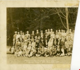
- Photograph is a panorama of the "BRACKMAN-KER MILLING CO. JUBILE(sic) PICNIC / BOWEN ISLAND, B.C. AUG.11th, 1928". The photograph presumably shows the employees and families of the Brackman-Ker Milling Co. The adults are mostly posed standing in four rows. There are some children being held in…
- Repository
- Burnaby Village Museum
- Collection/Fonds
- Burnaby Village Museum Photograph collection
- Description Level
- Item
- Physical Description
- 1 photograph : sepia ; panorama 53 x 20.2 cm
- Scope and Content
- Photograph is a panorama of the "BRACKMAN-KER MILLING CO. JUBILE(sic) PICNIC / BOWEN ISLAND, B.C. AUG.11th, 1928". The photograph presumably shows the employees and families of the Brackman-Ker Milling Co. The adults are mostly posed standing in four rows. There are some children being held in the arms of adults, but most of the children in the photograph are seated on the ground along the front of the group. There is also a dog lying down on the ground to the right side of the group. The group is posed in a grassy area, with trees and the roof of a square building visible in the background.
- Subjects
- Celebrations - Jubilee
- Accession Code
- HV971.1.35
- Access Restriction
- No restrictions
- Reproduction Restriction
- No known restrictions
- Date
- August 11, 1928
- Media Type
- Photograph
- Scan Resolution
- 600
- Scan Date
- 2023-03-23
- Photographer
- Stride, Charles Edgar
- Notes
- Title based on contents of photograph
- Title on front of photograph read: "BRACKMAN-KER MILLING CO. JUBILE(sic) PICNIC / BOWEN ISLAND, B.C. AUG.11th, 1928" and "PHOTO BY THE STRIDE STUDIOS / NEW WESTMINSTER, B.C."
Images
![Burnaby North High School Class of '53 reunion, [2004] thumbnail](/media/hpo/_Data/_Archives_Images/_Unrestricted/535/535-1771-1.jpg?width=280)
Burnaby North High School Class of '53 reunion
https://search.heritageburnaby.ca/link/archivedescription96020
- Repository
- City of Burnaby Archives
- Date
- [2004]
- Collection/Fonds
- Burnaby NewsLeader photograph collection
- Description Level
- File
- Physical Description
- 2 photographs (tiff) : col.
- Scope and Content
- File contains photographs of several alumni of the Class of '53 of Burnaby North High School at a presentation to donate $500 to the school's library. The photographs show the alumni standing in the library and posing with a yearbook.
- Repository
- City of Burnaby Archives
- Date
- [2004]
- Collection/Fonds
- Burnaby NewsLeader photograph collection
- Physical Description
- 2 photographs (tiff) : col.
- Description Level
- File
- Record No.
- 535-1771
- Access Restriction
- No restrictions
- Reproduction Restriction
- No restrictions
- Accession Number
- 2018-12
- Scope and Content
- File contains photographs of several alumni of the Class of '53 of Burnaby North High School at a presentation to donate $500 to the school's library. The photographs show the alumni standing in the library and posing with a yearbook.
- Media Type
- Photograph
- Photographer
- Bartel, Mario
- Notes
- Title based on caption
- Collected by editorial for use in a January 2004 issue of the Burnaby NewsLeader
- Caption from metadata: "The first reunion of Burnaby North's Class of '53 was so successful, the former grads were able to donate $500 to help the school's library. Fred Myers, Marilyn Myers, Rolf Nilson, Norma Nilson, Bob Kuhn, and Marie Kuhn are on hand for the presentation."
- Geographic Access
- Hammarskjold Drive
- Street Address
- 751 Hammarskjold Drive
- Planning Study Area
- Parkcrest-Aubrey Area
Images
![Burnaby North High School Class of '53 reunion, [2004] thumbnail](/media/hpo/_Data/_Archives_Images/_Unrestricted/535/535-1771-1.jpg)

Canada Day Celebration at Burnaby Village Museum
https://search.heritageburnaby.ca/link/museumdescription3340
- Repository
- Burnaby Village Museum
- Date
- July 1, 2003
- Collection/Fonds
- Burnaby Village Museum Photograph collection
- Description Level
- Item
- Physical Description
- 1 photograph : col. composite ; 26 x 18 cm laser print
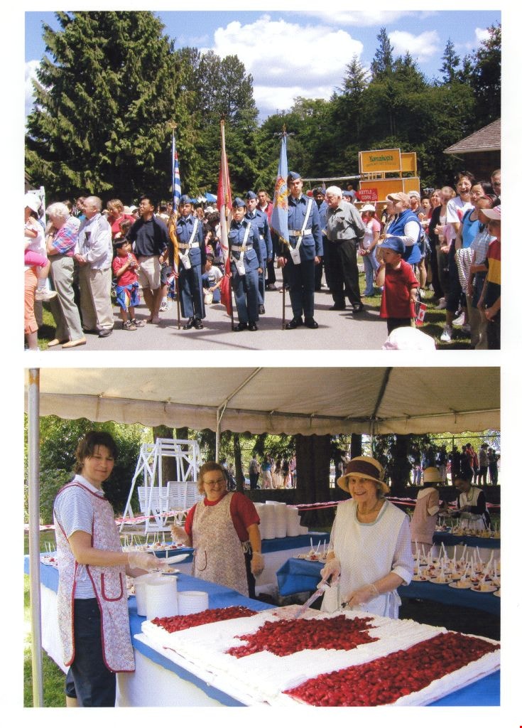
- Scope and Content
- Photograph is a composite of two images taken at the Canada Celebrations at the Burnaby Village Museum. Air cadets are marching with flag staffs as crowds stand by on either side in the first image and three women serve pieces of a large Canada Day cake in the second image.
- Repository
- Burnaby Village Museum
- Collection/Fonds
- Burnaby Village Museum Photograph collection
- Description Level
- Item
- Physical Description
- 1 photograph : col. composite ; 26 x 18 cm laser print
- Scope and Content
- Photograph is a composite of two images taken at the Canada Celebrations at the Burnaby Village Museum. Air cadets are marching with flag staffs as crowds stand by on either side in the first image and three women serve pieces of a large Canada Day cake in the second image.
- Subjects
- Celebrations
- Symbols - Flags
- Events - Parades
- Foods
- Names
- Burnaby Village Museum
- Accession Code
- BV004.35.2
- Access Restriction
- Restricted access
- Reproduction Restriction
- May be restricted by third party rights
- Date
- July 1, 2003
- Media Type
- Photograph
- Scan Resolution
- 600
- Scan Date
- 09-Jun-09
- Scale
- 100
- Photographer
- Low, Richard
- Notes
- Title based on contents of photograph
- Note in black ink on verso of photograph reads: "2003 Canada Day Celebration"
Images
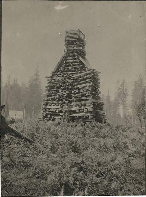
![Claude Hill in front of log pile, [1897] thumbnail](/media/hpo/_Data/_BVM_Images/1973/1973_0040_0002_001.jpg?width=280)
Claude Hill in front of log pile
https://search.heritageburnaby.ca/link/museumdescription989
- Repository
- Burnaby Village Museum
- Date
- [1897]
- Collection/Fonds
- Burnaby Village Museum Photograph collection
- Description Level
- Item
- Physical Description
- 1 photograph : sepia ; 9.6 x 7.1 cm mounted on cardboard 14.9 x 12.5 cm
- Scope and Content
- Photograph of a large stack of wood prepared for a bonfire on a hill. The bonfire stack is towering over a man who stands in front of it with his arms crossed and wearing a hat. There is a house seen in the background to the left of the photograph. The photograph is identified by the acquisition…
- Repository
- Burnaby Village Museum
- Collection/Fonds
- Burnaby Village Museum Photograph collection
- Description Level
- Item
- Physical Description
- 1 photograph : sepia ; 9.6 x 7.1 cm mounted on cardboard 14.9 x 12.5 cm
- Scope and Content
- Photograph of a large stack of wood prepared for a bonfire on a hill. The bonfire stack is towering over a man who stands in front of it with his arms crossed and wearing a hat. There is a house seen in the background to the left of the photograph. The photograph is identified by the acquisition record and inscription on the back as Queen Victoria's Jubilee bonfire. There is a discrepancy in the records as to who the man is. Some have identified him as Bernard Hill, others, as Mr. L.C. Hill. An annotation on th back of the photo reads, "1897/ Queen Victorias Jubilee/ Bonfire prepared by Mr LC Hill/ just above what is now Deer/ Lake Ave and below the/ present Centennial Pavilion."
- Subjects
- Celebrations - Jubilee
- Geographic Access
- Deer Lake
- Accession Code
- HV973.40.2
- Access Restriction
- No restrictions
- Reproduction Restriction
- No known restrictions
- Date
- [1897]
- Media Type
- Photograph
- Historic Neighbourhood
- Burnaby Lake (Historic Neighbourhood)
- Related Material
- For another photograph of the bonfire prepared by L. C. Hill, see photograph HV976.139.49
- Scan Resolution
- 600
- Scan Date
- 2023-05-09
- Scale
- 100
- Notes
- Title based on contents of photograph
Images
![Claude Hill in front of log pile, [1897] thumbnail](/media/hpo/_Data/_BVM_Images/1973/1973_0040_0002_001.jpg)
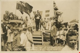
Diamond Jubilee of Confederation
https://search.heritageburnaby.ca/link/archivedescription34258
- Repository
- City of Burnaby Archives
- Date
- July 2, 1927
- Collection/Fonds
- Burnaby Historical Society fonds
- Description Level
- Item
- Physical Description
- 1 photograph : sepia ; 11.1 x 16.5 cm
- Scope and Content
- Photograph of the celebration of the Diamond Jubilee at Central Park. The event was held on July 2,1927 with a parade from the Municipal Hall at Edmonds along Kingsway to Central Park. Memorial services for those who died in the Great War were held at the Municipal Hall and the Memorial Hall, Royal…
- Repository
- City of Burnaby Archives
- Date
- July 2, 1927
- Collection/Fonds
- Burnaby Historical Society fonds
- Subseries
- George Jeffery subseries
- Physical Description
- 1 photograph : sepia ; 11.1 x 16.5 cm
- Description Level
- Item
- Record No.
- 013-002
- Access Restriction
- No restrictions
- Reproduction Restriction
- No known restrictions
- Accession Number
- BHS2007-04
- Scope and Content
- Photograph of the celebration of the Diamond Jubilee at Central Park. The event was held on July 2,1927 with a parade from the Municipal Hall at Edmonds along Kingsway to Central Park. Memorial services for those who died in the Great War were held at the Municipal Hall and the Memorial Hall, Royal Oak. Shown in this photograph is Reeve Bennett (Vancouver) addressing the crowd. Also on the dais are: ex-Reeve J.W. Weart, ex-Reeve T. Sanderson, Councillor Grimmett (Vancouver), Councillor Hall (Vancouver), Councillor Buckingham (South Vancouver), Burnaby's May Queen and suite, Leon Ladner (M.P.), and Miss Jean Cameron as "Miss Canada."
- Media Type
- Photograph
- Photographer
- Lloyd's Studio
- Notes
- Annotation at bottom of photographs reads, "Diamond Jubilee of Confederation / Burnaby, B.C., July 2nd '27"
- Back of photographs stamped, "Lloyd's Studio / 3966 Kingsway / McKay, B.C., Carl. 343R2"
- Geographic Access
- Imperial Street
- Central Park
- Street Address
- 3883 Imperial Street
- Historic Neighbourhood
- Central Park (Historic Neighbourhood)
- Planning Study Area
- Maywood Area
Images

Diamond Jubilee of Confederation
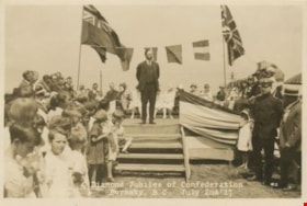
https://search.heritageburnaby.ca/link/archivedescription34259
- Repository
- City of Burnaby Archives
- Date
- July 2, 1927
- Collection/Fonds
- Burnaby Historical Society fonds
- Description Level
- Item
- Physical Description
- 1 photograph : sepia ; 11.1 x 16.5 cm
- Scope and Content
- Photograph of the celebration of the Diamond Jubilee at Central Park. The event was held on July 2, 1927 with a parade from the Municipal Hall at Edmonds along Kingsway to Central Park. Memorial services for those who died in the Great War were held at the Municipal Hall and the Memorial Hall, Roy…
- Repository
- City of Burnaby Archives
- Date
- July 2, 1927
- Collection/Fonds
- Burnaby Historical Society fonds
- Subseries
- George Jeffery subseries
- Physical Description
- 1 photograph : sepia ; 11.1 x 16.5 cm
- Description Level
- Item
- Record No.
- 013-003
- Access Restriction
- No restrictions
- Reproduction Restriction
- No known restrictions
- Accession Number
- BHS2007-04
- Scope and Content
- Photograph of the celebration of the Diamond Jubilee at Central Park. The event was held on July 2, 1927 with a parade from the Municipal Hall at Edmonds along Kingsway to Central Park. Memorial services for those who died in the Great War were held at the Municipal Hall and the Memorial Hall, Royal Oak. Shown in this photograph is MP Leon Ladner addressing the crowd. Also on the dais are: ex-Reeve J.W. Weart, ex-Reeve T. Sanderson, Reeve Bennett (Vancouver), Councillor Grimmett (Vancouver), Councillor Hall (Vancouver), Councillor Buckingham (South Vancouver), Burnaby's May Queen and suite, and Miss Jean Cameron as "Miss Canada."
- Media Type
- Photograph
- Photographer
- Lloyd's Studio
- Notes
- Title based on caption of photograph
- Annotation at bottom of photograph reads, "Diamond Jubilee of Confederation / Burnaby, B.C., July 2nd '27"
- Back of photograph stamped, "Lloyd's Studio / 3966 Kingsway / McKay, B.C., Carl. 343R2"
- Geographic Access
- Imperial Street
- Central Park
- Street Address
- 3883 Imperial Street
- Historic Neighbourhood
- Central Park (Historic Neighbourhood)
- Planning Study Area
- Maywood Area
Images
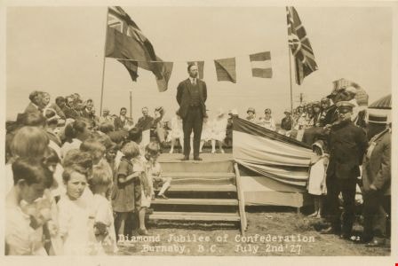
Diamond Jubilee of Confederation
https://search.heritageburnaby.ca/link/archivedescription34260
- Repository
- City of Burnaby Archives
- Date
- July 2, 1927
- Collection/Fonds
- Burnaby Historical Society fonds
- Description Level
- Item
- Physical Description
- 1 photograph : sepia ; 11.1 x 16.5 cm
- Scope and Content
- Photograph of the celebration of the Diamond Jubilee at Central Park. The event was held on July 2, 1927 with a parade from the Municipal Hall at Edmonds along Kingsway to Central Park. Memorial services for those who died in the Great War were held at the Municipal Hall and the Memorial Hall, Roy…
- Repository
- City of Burnaby Archives
- Date
- July 2, 1927
- Collection/Fonds
- Burnaby Historical Society fonds
- Subseries
- George Jeffery subseries
- Physical Description
- 1 photograph : sepia ; 11.1 x 16.5 cm
- Description Level
- Item
- Record No.
- 013-004
- Access Restriction
- No restrictions
- Reproduction Restriction
- No known restrictions
- Accession Number
- BHS2007-04
- Scope and Content
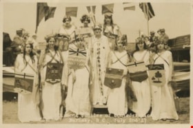
- Photograph of the celebration of the Diamond Jubilee at Central Park. The event was held on July 2, 1927 with a parade from the Municipal Hall at Edmonds along Kingsway to Central Park. Memorial services for those who died in the Great War were held at the Municipal Hall and the Memorial Hall, Royal Oak. Shown in this photograph are Miss Canada, Jean Cameron, and other young women representing each province in the Dominion standing on the stage. Also on the dais are: ex-Reeve J.W. Weart, ex-Reeve T. Sanderson, Reeve Bennett (Vancouver), Councillor Grimmett (Vancouver), Councillor Hall (Vancouver), Councillor Buckingham (South Vancouver), and MP Leon Ladner.
- Media Type
- Photograph
- Photographer
- Lloyd's Studio
- Notes
- Title based on caption of photograph
- Annotation at bottom of photographs reads, "Diamond Jubilee of Confederation / Burnaby, B.C., July 2nd '27"
- Back of photographs stamped, "Lloyd's Studio / 3966 Kingsway / McKay, B.C., Carl. 343R2"
- Geographic Access
- Imperial Street
- Central Park
- Street Address
- 3883 Imperial Street
- Historic Neighbourhood
- Central Park (Historic Neighbourhood)
- Planning Study Area
- Maywood Area
Images

Diamond Jubilee of Confederation
https://search.heritageburnaby.ca/link/archivedescription34261
- Repository
- City of Burnaby Archives
- Date
- July 2, 1927
- Collection/Fonds
- Burnaby Historical Society fonds
- Description Level
- Item
- Physical Description
- 1 photograph : b&w ; 11.1 x 16.6 cm
- Scope and Content
- Photograph of the celebration of the Diamond Jubilee at Central Park. Miss Canada, Jean Cameron, is addressing the crowd. Also on the dais are; ex-Reeve J.W. Weart, ex-Reeve T. Sanderson, Reeve Bennett (Vancouver), Councillor Grimmett (Vancouver), Councillor Hall (Vancouver), Councillor Buckingham …
- Repository
- City of Burnaby Archives
- Date
- July 2, 1927
- Collection/Fonds
- Burnaby Historical Society fonds
- Subseries
- George Jeffery subseries
- Physical Description
- 1 photograph : b&w ; 11.1 x 16.6 cm
- Description Level
- Item
- Record No.
- 013-005
- Access Restriction
- No restrictions
- Reproduction Restriction
- No known restrictions
- Accession Number
- BHS2007-04
- Scope and Content
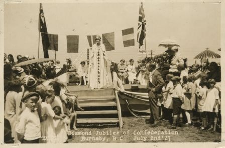
- Photograph of the celebration of the Diamond Jubilee at Central Park. Miss Canada, Jean Cameron, is addressing the crowd. Also on the dais are; ex-Reeve J.W. Weart, ex-Reeve T. Sanderson, Reeve Bennett (Vancouver), Councillor Grimmett (Vancouver), Councillor Hall (Vancouver), Councillor Buckingham (South Vancouver), Burnaby's May Queen and her suite and MP Leon Ladner. The event was held on July 2, 1927 with a parade from the Municipal Hall at Edmonds along Kingsway to Central Park. Memorial services for those who died in the Great War were held at the Municipal Hall and the Memorial Hall, on Royal Oak.
- Subjects
- Celebrations - Jubilee
- Officials
- Media Type
- Photograph
- Photographer
- Lloyd's Studio
- Notes
- Title based on caption of photograph
- Annotation at bottom of photograph reads, "Diamond Jubilee of Confederation / Burnaby, B.C., July 2nd '27"
- Back of photograph stamped, "Lloyd's Studio / 3966 Kingsway / McKay, B.C., Carl. 343R2"
- Geographic Access
- Imperial Street
- Central Park
- Street Address
- 3883 Imperial Street
- Historic Neighbourhood
- Central Park (Historic Neighbourhood)
- Planning Study Area
- Maywood Area
Images
Diamond Jubilee Parade
https://search.heritageburnaby.ca/link/archivedescription34262
- Repository
- City of Burnaby Archives
- Date
- July 2, 1927
- Collection/Fonds
- Burnaby Historical Society fonds
- Description Level
- Item
- Physical Description
- 1 photograph : b&w ; 10.9 x 16.4 cm
- Scope and Content
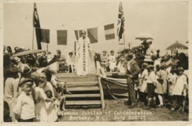
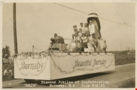
- Photograph of Diamond Jubilee celebrations at Central Park. Miss Canada, Jean Cameron is on a float with other young women representing each province of the Dominion. Note the paper mache beaver pulling the throne. The event was held on July 2, 1927 with a parade from the Municipal Hall at Edmonds …
- Repository
- City of Burnaby Archives
- Date
- July 2, 1927
- Collection/Fonds
- Burnaby Historical Society fonds
- Subseries
- George Jeffery subseries
- Physical Description
- 1 photograph : b&w ; 10.9 x 16.4 cm
- Description Level
- Item
- Record No.
- 013-006
- Access Restriction
- No restrictions
- Reproduction Restriction
- No known restrictions
- Accession Number
- BHS2007-04
- Scope and Content
- Photograph of Diamond Jubilee celebrations at Central Park. Miss Canada, Jean Cameron is on a float with other young women representing each province of the Dominion. Note the paper mache beaver pulling the throne. The event was held on July 2, 1927 with a parade from the Municipal Hall at Edmonds along Kingsway to Central Park. Memorial services for those who died in the Great War were held at the Municipal Hall and the Memorial Hall, on Royal Oak.
- Names
- Cameron, Jean
- Media Type
- Photograph
- Photographer
- Lloyd's Studio
- Notes
- Title based on caption of photograph
- Annotation at bottom of photograph reads, "Diamond Jubilee of Confederation / Burnaby, B.C., July 2nd '27"
- Back of photograph stamped, "Lloyd's Studio / 3966 Kingsway / McKay, B.C., Carl. 343R2"
- Geographic Access
- Imperial Street
- Street Address
- 3883 Imperial Street
- Historic Neighbourhood
- Central Park (Historic Neighbourhood)
- Planning Study Area
- Maywood Area
Images
Diamond Jubliee Committee
https://search.heritageburnaby.ca/link/museumdescription3184
- Repository
- Burnaby Village Museum
- Date
- 2 Jul 1927
- Collection/Fonds
- Burnaby Village Museum Photograph collection
- Description Level
- Item
- Physical Description
- 1 photograph : b&w ; 13.5 x 24 cm (sight) in matt 30.5 x 39.5 cm in frame 41.5 x 49.5 cm
- Scope and Content
- Photograph of The Committee of the Diamond Jubilee of Confederation. Group portrait is composed of a group of men in two rows, five seated in front row, seven men standing in back fow with young girl standing next to man on the right. Man in centre of front row is holding a photograph and has a meg…
- Repository
- Burnaby Village Museum
- Collection/Fonds
- Burnaby Village Museum Photograph collection
- Description Level
- Item
- Physical Description
- 1 photograph : b&w ; 13.5 x 24 cm (sight) in matt 30.5 x 39.5 cm in frame 41.5 x 49.5 cm
- Material Details
- Photograph mounted in matt within an oak wood frame
- Scope and Content
- Photograph of The Committee of the Diamond Jubilee of Confederation. Group portrait is composed of a group of men in two rows, five seated in front row, seven men standing in back fow with young girl standing next to man on the right. Man in centre of front row is holding a photograph and has a megaphone between his legs. The group are assembled together in what might be a park in Burnaby. There are houses and telephone poles visible in the background.
- Accession Code
- BV985.5401.1
- Access Restriction
- No restrictions
- Reproduction Restriction
- No known restrictions
- Date
- 2 Jul 1927
- Media Type
- Photograph
- Photographer
- Lloyd, Frank Ernest
- Notes
- Title based on contents of photograph
- Annotations on bottom of matt in white ink reads: "The Committee _Diamond Jubilee of Confederation, Burnaby July 2nd 1927 / Lloyd Studio / McKay, B.C."
Images

![Frank Campbell addressing the haggis, [2000] thumbnail](/media/hpo/_Data/_Archives_Images/_Unrestricted/535/535-1963.jpg?width=280)
Frank Campbell addressing the haggis
https://search.heritageburnaby.ca/link/archivedescription96280
- Repository
- City of Burnaby Archives
- Date
- [2000]
- Collection/Fonds
- Burnaby NewsLeader photograph collection
- Description Level
- Item
- Physical Description
- 1 photograph (tiff) : b&w
- Scope and Content
- Photograph of Frank Campbell performing the address to the haggis during a Robbie Burns Day celebration at Simon Fraser University. A bagpiper, dressed in a traditional bagpiper's uniform, watches from the background.
- Repository
- City of Burnaby Archives
- Date
- [2000]
- Collection/Fonds
- Burnaby NewsLeader photograph collection
- Physical Description
- 1 photograph (tiff) : b&w
- Description Level
- Item
- Record No.
- 535-1963
- Access Restriction
- No restrictions
- Reproduction Restriction
- No restrictions
- Accession Number
- 2018-12
- Scope and Content
- Photograph of Frank Campbell performing the address to the haggis during a Robbie Burns Day celebration at Simon Fraser University. A bagpiper, dressed in a traditional bagpiper's uniform, watches from the background.
- Names
- Simon Fraser University
- Media Type
- Photograph
- Photographer
- Bartel, Mario
- Notes
- Title based on caption
- Collected by editorial for use in a January 2000 issue of the Burnaby NewsLeader
- Caption from metadata: "Frank Campbell addresses the haggis at a Robbie Burns Day ceremony at the Diamond University Centre at Simon Fraser University."
- Geographic Access
- Burnaby Mountain Conservation Area
- University Drive
- Street Address
- 8888 University Drive
- Planning Study Area
- Burnaby Mountain Area
Images
![Frank Campbell addressing the haggis, [2000] thumbnail](/media/hpo/_Data/_Archives_Images/_Unrestricted/535/535-1963.jpg)
![HMS Delhi at Melbourne Harbour, Australia, [1924] thumbnail](/media/hpo/_Data/_BVM_Images/1984/1984_0051_0056_001.jpg?width=280)
HMS Delhi at Melbourne Harbour, Australia
https://search.heritageburnaby.ca/link/museumdescription272
- Repository
- Burnaby Village Museum
- Date
- [1924]
- Collection/Fonds
- Burnaby Village Museum Photograph collection
- Description Level
- Item
- Physical Description
- 1 photograph : b&w ; 8.2 x 13.4 cm
- Scope and Content
- Photograph of a large military ship at a harbour in Melbourne, Australia. There are streamers decorating the ship that extend out to the harbour . There are men in navy uniforms on the boat, looking towards the people gathered at the dock. Most people are in suits and dresses. A crane can be see…
- Repository
- Burnaby Village Museum
- Collection/Fonds
- Burnaby Village Museum Photograph collection
- Description Level
- Item
- Physical Description
- 1 photograph : b&w ; 8.2 x 13.4 cm
- Scope and Content
- Photograph of a large military ship at a harbour in Melbourne, Australia. There are streamers decorating the ship that extend out to the harbour . There are men in navy uniforms on the boat, looking towards the people gathered at the dock. Most people are in suits and dresses. A crane can be seen in the lower right corner of the photograph.
- Accession Code
- HV984.51.56
- Access Restriction
- No restrictions
- Reproduction Restriction
- No known restrictions
- Date
- [1924]
- Media Type
- Photograph
- Scan Resolution
- 600
- Scan Date
- 2023-10-31
- Notes
- Title based on contents of photograph
- An annotation on the front of the photo reads: "Leaving Melbourne 1924." Annotations on the back of the photo read: "Arthur Been E.R.A / H.M.S. Delhi / S.S.S. / Y.P.G" and "If it wasn't for trouble how could we appreciate Happinees / AB[underlined]."
Images
![HMS Delhi at Melbourne Harbour, Australia, [1924] thumbnail](/media/hpo/_Data/_BVM_Images/1984/1984_0051_0056_001.jpg)