Narrow Results By
Person / Organization
- Burnaby Central Secondary School 1
- Douglas Road School 1
- Dowad, Kathleen "Kay" 1
- Dowad, Martha Elias Shaheen 1
- Dowad, Naomi "Mamie" David 1
- Dowad, Norman W. "Norm" 1
- Dowad, Samuel Esper "Sam" 1
- Dowad, Wilfred "Wilf" 1
- Hill, Louis Claude "Claude" 1
- ʷməθkʷəy̓əm (Musqueam) 1
- Rideout, Dr. John Anthony 1
- Waplington, John "Jack" 1
![Brookfield, [1896] thumbnail](/media/hpo/_Data/_BVM_Images/1973/1973_0040_0001_001.jpg?width=280)
Brookfield
https://search.heritageburnaby.ca/link/museumdescription988
- Repository
- Burnaby Village Museum
- Date
- [1896]
- Collection/Fonds
- Burnaby Village Museum Photograph collection
- Description Level
- Item
- Physical Description
- 1 photograph : b&w ; 12.1 x 17.7 cm
- Scope and Content
- Photograph of the house built about 1894 that Louis Claud Hill called "Brookfield." Mr. Hill was married that year to Annie Sara Kendrick, and they took up residence in the house until 1906 when they sold the property and built a new home in the vicinity of Buckingham and Sperling. Brookfield was…
- Repository
- Burnaby Village Museum
- Collection/Fonds
- Burnaby Village Museum Photograph collection
- Description Level
- Item
- Physical Description
- 1 photograph : b&w ; 12.1 x 17.7 cm
- Scope and Content
- Photograph of the house built about 1894 that Louis Claud Hill called "Brookfield." Mr. Hill was married that year to Annie Sara Kendrick, and they took up residence in the house until 1906 when they sold the property and built a new home in the vicinity of Buckingham and Sperling. Brookfield was still on the property when the Burnaby Village Museum was planned in 1971 as Heritage Village, but it was torn down to make room for other buildings on the site. An acquisition record notes that this house stood immediately behind the Elworth House, and Colonel Peers' (the donor) mother was born in this house in 1898. Annotations on the back of the photo read, "1896 'Brookfield'" and "The residence of Mr.+Mrs. LC Hill, the first residence on the site of Heritage Court. It stood immediately behind what is now called the Manor House. Built about 1894."
- Subjects
- Buildings - Residential - Houses
- Geographic Access
- Deer Lake Avenue
- Street Address
- 6501 Deer Lake Avenue
- Accession Code
- HV973.40.1
- Access Restriction
- No restrictions
- Reproduction Restriction
- No known restrictions
- Date
- [1896]
- Media Type
- Photograph
- Historic Neighbourhood
- Burnaby Lake (Historic Neighbourhood)
- Planning Study Area
- Morley-Buckingham Area
- Scan Resolution
- 600
- Scan Date
- 2023-05-09
- Scale
- 100
- Notes
- Title based on contents of photograph
Images
![Brookfield, [1896] thumbnail](/media/hpo/_Data/_BVM_Images/1973/1973_0040_0001_001.jpg)
![Deer Lake, [1914] thumbnail](/media/hpo/_Data/_BVM_Images/1971/197200110006.jpg?width=280)
Deer Lake
https://search.heritageburnaby.ca/link/museumdescription3092
- Repository
- Burnaby Village Museum
- Date
- [1914]
- Collection/Fonds
- Burnaby Village Museum Photograph collection
- Description Level
- Item
- Physical Description
- 1 photograph : b&w glass negative ; 16.0 x 20.9 cm
- Scope and Content
- Photograph of the north shore of Deer Lake looking northwest. According to a 1988 catalogue record, visible is the T.O. Townley house, "Deerholme," and the Gardener's cottage (marred by a stain). Ceperley's "Fairacres" is also visible to the extreme right of the contact print, including a boathous…
- Repository
- Burnaby Village Museum
- Collection/Fonds
- Burnaby Village Museum Photograph collection
- Description Level
- Item
- Physical Description
- 1 photograph : b&w glass negative ; 16.0 x 20.9 cm
- Scope and Content
- Photograph of the north shore of Deer Lake looking northwest. According to a 1988 catalogue record, visible is the T.O. Townley house, "Deerholme," and the Gardener's cottage (marred by a stain). Ceperley's "Fairacres" is also visible to the extreme right of the contact print, including a boathouse on the shore which can be seen on the centre of the print.
- Geographic Access
- Price Street
- Deer Lake
- Street Address
- 6110 Price Street
- Accession Code
- HV972.11.6
- Access Restriction
- No restrictions
- Reproduction Restriction
- No known restrictions
- Date
- [1914]
- Media Type
- Photograph
- Historic Neighbourhood
- Burnaby Lake (Historic Neighbourhood)
- Planning Study Area
- Morley-Buckingham Area
- Related Material
- For other shots of the Deer Lake in the same accession, see HV972.11.16 and HV972.11.18
- Scan Resolution
- 300
- Scan Date
- 14/8/2006
- Scale
- 100
- Notes
- Title based on contents of photograph
- 1 b&w contact print accompanying negative
Images
![Deer Lake, [1914] thumbnail](/media/hpo/_Data/_BVM_Images/1971/197200110006.jpg)
![Interview with Norman Dowad, [1890-2023] (interview content), interviewed 14 Aug. 2023 thumbnail](/media/hpo/_Data/_BVM_Sound_Recordings/Oral_Histories/2023_0016_0016_001.jpg?width=280)
Interview with Norman Dowad
https://search.heritageburnaby.ca/link/museumdescription19638
- Repository
- Burnaby Village Museum
- Date
- [1890-2023] (interview content), interviewed 14 Aug. 2023
- Collection/Fonds
- Burnaby Village Museum fonds
- Description Level
- Item
- Physical Description
- 1 sound recording (wav) (61 min., 37 sec.) + 1 sound recording (mp3) (61 min., 37 sec.)
- Scope and Content
- Item consists of a recording of an oral history interview with Norman Dowad conducted by Burnaby Village Museum Registrar, Eric Damer on August 14, 2023. 00:00:00 – 00:14:38 Norm shares biographical information about himself and background information on the Dowad family. Norm conveys information …
- Repository
- Burnaby Village Museum
- Collection/Fonds
- Burnaby Village Museum fonds
- Series
- Museum Oral Histories series
- Subseries
- Many Voices Project Interviews subseries
- Description Level
- Item
- Physical Description
- 1 sound recording (wav) (61 min., 37 sec.) + 1 sound recording (mp3) (61 min., 37 sec.)
- Material Details
- Interviewer: Eric Damer Interviewee: Norman Dowad Location of Interview: Burnaby Village Museum Interview Date: August 14, 2023 Total Number of tracks: 1 Total Length of all Tracks: 01:14:37 Digital master recording (wav) was converted to mp3 for access on Heritage Burnaby
- Scope and Content
- Item consists of a recording of an oral history interview with Norman Dowad conducted by Burnaby Village Museum Registrar, Eric Damer on August 14, 2023. 00:00:00 – 00:14:38 Norm shares biographical information about himself and background information on the Dowad family. Norm conveys information about his grandfather Samuel Dowad's immigration to Canada and his father Wilfred Dowad's military service and successes as a property developer. 00:14:39 – 00:17:26 Norm provides background information on his mother’s side of the family. 00:17:27 – 00:31:36 Norm talks about his childhood, growing up in the Deer Lake neighbourhood, his early education in Burnaby and sports that he played. 00:31:37 – 00:39:59 Norm talks about his educational experiences attending Simon Fraser University, University of British Columbia and Osgoode Hall law school and information regarding his law career. 00:40:00 – 00:45:03 Norm reflects on his childhood growing up in Burnaby and on his experiences and relationships as a student and in his career as a lawyer. 00:45:04 – 01:01:37 Norm talks about his siblings and shares information about family property development projects as well as career and business successes. In closing he talks about research that he’s done through Archives Canada on his grandfather Sam Dowad and father Wilfred Dowad.
- History
- Interviewee biography: Normam Dowad was born and rasied in Burnaby. Norm graduated from Burnaby Central Secondary School, Simon Fraser University for one year, and obtained his law degree from York University. Norman began practicing law in 1974 years and has his own law practice that he operates out of Vancouver as of 2023. Interviewer biography: Eric Damer is a Burnaby Village Museum Interpreter, Museum Registrar, Researcher and Blacksmith. Eric pounded hot steel for the first time in 1977 in junior high. Fifteen years later, he joined Burnaby Village Museum where he has smithed for three decades. He also provides historical research for museum exhibits and special projects. Outside the museum, Eric is a social historian with a special interest in educational history.
- Creator
- Burnaby Village Museum
- Subjects
- Agriculture - Farms
- Education
- Persons - South Asian Canadians
- Migration
- Sports
- Sports - Football
- Wars - World War, 1939-1945
- Names
- Dowad, Norman W. "Norm"
- Dowad, Samuel Esper "Sam"
- Dowad, Wilfred "Wilf"
- Dowad, Naomi "Mamie" David
- Dowad, Martha Elias Shaheen
- Dowad, Kathleen "Kay"
- Rideout, Dr. John Anthony
- Burnaby Central Secondary School
- Douglas Road School
- W. Dowad Limited
- Responsibility
- Damer, Eric
- Geographic Access
- Buckingham Avenue
- Deer Lake
- Street Address
- 5533 Buckingham Avenue
- Accession Code
- BV023.16.16
- Access Restriction
- No restrictions
- Reproduction Restriction
- No known restrictions
- Date
- [1890-2023] (interview content), interviewed 14 Aug. 2023
- Media Type
- Sound Recording
- Historic Neighbourhood
- Burnaby Lake (Historic Neighbourhood)
- Planning Study Area
- Morley-Buckingham Area
- Notes
- Title based on contents of item
- Transcription available
Images
![Interview with Norman Dowad, [1890-2023] (interview content), interviewed 14 Aug. 2023 thumbnail](/media/hpo/_Data/_BVM_Sound_Recordings/Oral_Histories/2023_0016_0016_001.jpg)
Documents
Audio Tracks
Interview with Norman Dowad, [1890-2023] (interview content), interviewed 14 Aug. 2023
Interview with Norman Dowad, [1890-2023] (interview content), interviewed 14 Aug. 2023
https://search.heritageburnaby.ca/media/hpo/_Data/_BVM_Sound_Recordings/Oral_Histories/2023_0016_0016_002.mp3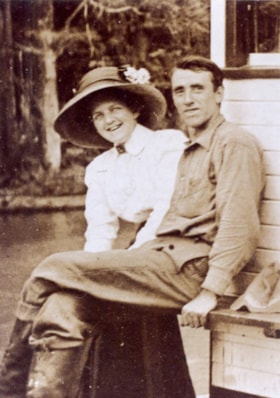
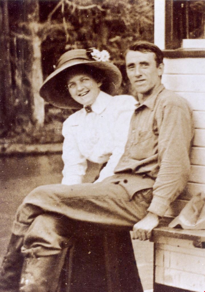
Jack and Sarah Waplington
https://search.heritageburnaby.ca/link/museumdescription5076
- Repository
- Burnaby Village Museum
- Date
- 1911
- Collection/Fonds
- Waplington family fonds
- Description Level
- Item
- Physical Description
- 1 photograph : col. copy print 13 x 9.5 cm
- Scope and Content
- Photograph of Jack and Sara Waplington who were married in 1911. Sarah is wearing a white blouse and a large hat with a floral corrsage on top while Jack is wearing a dark coloured shirt, pants and high topped boots. Both are seated outside an unidentified building.
- Repository
- Burnaby Village Museum
- Collection/Fonds
- Waplington family fonds
- Description Level
- Item
- Physical Description
- 1 photograph : col. copy print 13 x 9.5 cm
- Scope and Content
- Photograph of Jack and Sara Waplington who were married in 1911. Sarah is wearing a white blouse and a large hat with a floral corrsage on top while Jack is wearing a dark coloured shirt, pants and high topped boots. Both are seated outside an unidentified building.
- Geographic Access
- Deer Lake
- Deer Lake Avenue
- Accession Code
- BV016.46.53
- Access Restriction
- No restrictions
- Reproduction Restriction
- No known restrictions
- Date
- 1911
- Media Type
- Photograph
- Historic Neighbourhood
- Burnaby Lake (Historic Neighbourhood)
- Planning Study Area
- Morley-Buckingham Area
- Scan Resolution
- 600
- Scan Date
- 13-Aug-2018
- Notes
- Title based on contents of photograph
- Note in blue ink on verso of photograph reads: "Frances L's parents / Sara and Jack Waplington"
- Photograph is part of Photograph album BV016.46.52
Images
![Survey and Subdivision plans in New Westminster District Group 1 and Group 2 – Vancouver, ʷməθkʷəy̓əm (Musqueam) Indian Reserve, Burnaby, Surrey
, [1910-1911] thumbnail](/media/hpo/_Data/_BVM_Cartographic_Material/1977/1977_0093_0017_001.jpg?width=280)
Survey and Subdivision plans in New Westminster District Group 1 and Group 2 – Vancouver, ʷməθkʷəy̓əm (Musqueam) Indian Reserve, Burnaby, Surrey
https://search.heritageburnaby.ca/link/museumdescription6986
- Repository
- Burnaby Village Museum
- Date
- [1910-1911]
- Collection/Fonds
- Burnaby Village Museum Map collection
- Description Level
- File
- Physical Description
- 9 plans : 4 plans : blueprint ink on paper + 4 plans : black ink on paper + 1 plan : graphite on paper mounted on 2 sides of cardboard 76 x 102 cm
- Scope and Content
- File consists of a large board of three survey plans in New Westminster District Group 1 mounted on one side and six survey and subdivision plans of District Lot 85, New Westminster District Group 1 mounted on the other side. Side A: 1. Plan : blueprint on paper ; 30.5 x 80 cm. Title reads: "Fras…
- Repository
- Burnaby Village Museum
- Collection/Fonds
- Burnaby Village Museum Map collection
- Description Level
- File
- Physical Description
- 9 plans : 4 plans : blueprint ink on paper + 4 plans : black ink on paper + 1 plan : graphite on paper mounted on 2 sides of cardboard 76 x 102 cm
- Material Details
- Scales vary (One chain equals 792 inches)
- Indexed number on tape on edge of board reads "17"
- Scope and Content
- File consists of a large board of three survey plans in New Westminster District Group 1 mounted on one side and six survey and subdivision plans of District Lot 85, New Westminster District Group 1 mounted on the other side. Side A: 1. Plan : blueprint on paper ; 30.5 x 80 cm. Title reads: "Fraser River Bridge / Plan of South Approach". Plan covers area of land north of the Fraser River and Great Northern Railway with approach for a bridge running through the "ʷməθkʷəy̓əm (Musqueam) Indian Reserve" (ʷməθkʷəy̓əm (Musqueam) First Nation) and lots marked as Dominion Government and the east half of Lot 2 identified as "C. F. Brown" "Plan 851". Plan is identified as "Plan 851 / traced / Mar. 17, 1911". (Geographic location in Vancouver) Scale: 100 feet = 1 inch, Signed by Albert J. Hill / P.L.S." 2. Plan : blueprint on paper ; 36.5 x 35 cm (no title). Includes three plans of lots on the east and west sides of North Road. Note on bottom of blueprint reads: "I.E.B. McKay Surveyor General - hereby certify / that this is a correct tracing from the field / notes of the Royal Engineers on file in the / Lands Department / E.B. McKay (signature) / Surveyor General / Victoria B.C. April 11th 1911" . Plan in top left titled "Page 11 / Vol. 1. / R.E. Notes" covers District Lots east of North Road including Lot 5, Lot 7, Lot 41, Lot 9 and Lot 107 in Coquitlam. Plan in top right corner titled "Page 17 / Vol. 1. / R.E. Notes" covers District Lots east of North Road including Lot 104, Lot 54, Lot 105, Lot 55, Lot 106, Lot 9 and Lot 107 in Coquitlam and Port Moody. Plan in lower left corner titled "Page 15 / Vol. 1 / R.E. Notes" covers District Lots west of North Road including Lot 147, Lot 148, Lot 100, Lot 15 in Burnaby. 3. Plan : blue print on paper ; 29.5 x 41.5 cm. (no formal title). Plan of the North 1/2 of Section 18. Plan covers area in the "North 1/2 of Sec.18 B.5 N RGE 1 W" and "Sec. 18 B.5 N. RGE 1 W" bordered by Section 7, Section 13, Section 17 and Section 19. Bon Accord Road runs through Sec. 18. The plan is signed by surveryor "I.H. Neville Smith... C.E.B.C.L.S. / Mar. 26th 1910" and signed by "Ludwig Pillath". (Geographic location: Surrey) Side B: 1. Plan : blueprint on paper ; 43.5 x 49.5 cm. Title reads: "Plan / of Subdivision / of a Portion / of / Lot 85 / Group One / New Westminster District. Plan covers portion of land east of Deer Lake and Pole Line Road (Sperling Avenue) and south of Hastings Road in District Lot 85 in Burnaby with section 4 and a portion of section 2 coloured in red. Plan is signed by "Albert J. Hill, B.C.L.S." Plan is initialed by: "RB" [sic] (in blue pencil crayon) Scale: 4 chains = 1 inch 2. Plaln : black black ink on linen ; 39 x 37 cm. Title reads: "L.C. Hill's Property, / Burnaby". Plan covers a triangular portion of land east of Pole Line Road (Sperling Avenue) and south of Hastings Road in District Lot 85 in Burnaby. Plan is intitaled by "RB" [sic] (in blue pencil crayon). Scale: 3 chains = 1 mile 3. Plan : graphite on paper ; 23 x 17 cm. Title reads: "Portion of Lot 85 / Gr.1". Plan covers portion of land north east of Deer Lake and west of Pole Line Road (now Sperling Avenue) in District Lot 85 in Burnaby. Plan is stamped in red ink: "Albert J. Hill, Civil Engineer". Plan is initialed by: "RB" [sic] (in blue pencil crayon). Scale: 1 chain = 1 inch 4. Plan : black ink on linen ; 16 x 19 cm. Title reads: "Lot 85". Plan covers the intersection of Pole Line Road (Sperling Avenue) and Hastings Road at the north west section of District Lot 79 and District Lot 85 in Burnaby. Plan is stamped: "A.J. Hill, Civil Engineer" with identitifed in blue pencil crayon. 5. Plan : black ink on paper ; 28.5 x 37 cm. (no formal title) Plan covers an area of land, west of Pole Line Road (Sperling Avenue) and south of Deer Lake in District Lot 85 in Burnaby. Plan is initialed by: "RB" [sic] (in blue pencil crayon) 6. Plan : black ink on paper ; 21 x 34 cm (no formal title). Plan covers an area of land, west of Pole Line Road (Sperling Avenue) and south of Deer Lake in District Lot 85 in Burnaby. Plan is initialed by: "RB" [sic] (in blue pencil crayon)
- Accession Code
- HV977.93.17
- Access Restriction
- No restrictions
- Reproduction Restriction
- No known restrictions
- Date
- [1910-1911]
- Media Type
- Cartographic Material
- Historic Neighbourhood
- Burnaby Lake (Historic Neighbourhood)
- Burquitlam (Historic Neighbourhood)
- Planning Study Area
- Morley-Buckingham Area
- Douglas-Gilpin Area
- Scan Resolution
- 600
- Scan Date
- 2023-06-26
- Notes
- Title based on contents of file
- Scale is measured in chains and feet. (One chain equals 792 inches).
- The term "Lot" also refers to a "District Lot”
- Some plans are stamped: "Albert J. Hill, Civil Engineer / and / Provincial Land Surveyor, / New Westminster, / B.C." and intialed: "RB" [sic]
Zoomable Images
![Survey and Subdivision plans in New Westminster District Group 1 and Group 2 – Vancouver, ʷməθkʷəy̓əm (Musqueam) Indian Reserve, Burnaby, Surrey
, [1910-1911] thumbnail](/media/hpo/_Data/_BVM_Cartographic_Material/1977/1977_0093_0017_003_seadragon/1977_0093_0017_003.jpg?w=280)
Survey and Subdivision plans in New Westminster District Group 1 and Group 2 – Vancouver, ʷməθkʷəy̓əm (Musqueam) Indian Reserve, Burnaby, Surrey , [1910-1911]
Zoom into Image