Narrow Results By
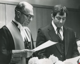
Justice G. L. Murray swearing in Mayor Dave Mercier
https://search.heritageburnaby.ca/link/archivedescription46289
- Repository
- City of Burnaby Archives
- Date
- March 11, 1980
- Collection/Fonds
- Columbian Newspaper collection
- Description Level
- Item
- Physical Description
- 1 photograph : b&w ; 19 x 24 cm
- Scope and Content
- Photograph of Justice G. L. Murray administrating the oath of office to Mayor Dave Mercier. Dave Mercier was a council member from 1968 to 1971, and from 1977 to 1981, serving as Mayor from 1979 to 1981.
- Repository
- City of Burnaby Archives
- Date
- March 11, 1980
- Collection/Fonds
- Columbian Newspaper collection
- Physical Description
- 1 photograph : b&w ; 19 x 24 cm
- Description Level
- Item
- Record No.
- 480-1177
- Access Restriction
- No restrictions
- Reproduction Restriction
- No restrictions
- Accession Number
- 2003-02
- Scope and Content
- Photograph of Justice G. L. Murray administrating the oath of office to Mayor Dave Mercier. Dave Mercier was a council member from 1968 to 1971, and from 1977 to 1981, serving as Mayor from 1979 to 1981.
- Media Type
- Photograph
- Photographer
- King, Basil
- Notes
- Title based on contents of photograph
- Geographic Access
- Canada Way
- Street Address
- 4949 Canada Way
- Historic Neighbourhood
- Burnaby Lake (Historic Neighbourhood)
- Planning Study Area
- Douglas-Gilpin Area
Images

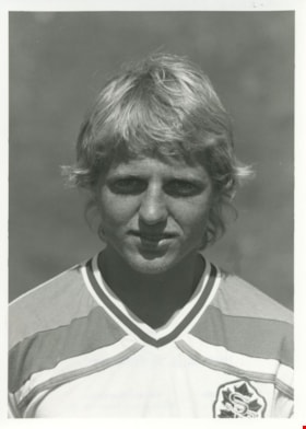
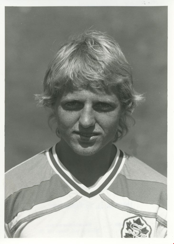
Murray Muskeyn
https://search.heritageburnaby.ca/link/archivedescription45320
- Repository
- City of Burnaby Archives
- Date
- 1982
- Collection/Fonds
- Columbian Newspaper collection
- Description Level
- Item
- Physical Description
- 1 photograph : b&w ; 16.5 x 11.5 cm
- Scope and Content
- Photograph of Murray Muskeyn when he was a member of the Simon Fraser University soccer team.
- Repository
- City of Burnaby Archives
- Date
- 1982
- Collection/Fonds
- Columbian Newspaper collection
- Physical Description
- 1 photograph : b&w ; 16.5 x 11.5 cm
- Description Level
- Item
- Record No.
- 480-215
- Access Restriction
- No restrictions
- Reproduction Restriction
- Reproduce for fair dealing purposes only
- Accession Number
- 2003-02
- Scope and Content
- Photograph of Murray Muskeyn when he was a member of the Simon Fraser University soccer team.
- Subjects
- Sports - Soccer
- Sports - Team Sports
- Names
- Muskeyn, Murray
- Media Type
- Photograph
- Photographer
- Thompson, John M.
- Notes
- Title based on contents of photograph
Images

The Model T Ford owner
https://search.heritageburnaby.ca/link/museumlibrary915
- Repository
- Burnaby Village Museum
- Collection
- Reference Collection
- Material Type
- Book
- ISBN
- 091116023X
- 9780911160239
- Call Number
- 629.2 FAN
- Place of Publication
- Arcadia, CA
- Publisher
- Post-Era Books
- Publication Date
- c1983
- Physical Description
- 519 p. : ill. ; 24 cm.
- Library Subject (LOC)
- Ford Model T automobile
- Notes
- Includes index.

Pioneer tales of Burnaby
https://search.heritageburnaby.ca/link/museumlibrary5860
- Repository
- Burnaby Village Museum
- Collection
- Digital Reference Collection
- Reference Collection
- Material Type
- Book
- ISBN
- 096928280x
- Call Number
- 971.133 SON COPY 4
- Contributor
- Sone, Michael
- Place of Publication
- Burnaby, B.C.
- Publisher
- Corporation of the District of Burnaby
- Publication Date
- c1987
- Physical Description
- 495 p. : ill. ; 31 cm.
- Inscription
- "TR687 - Bryburgh" / handprinted in pencil on frontend page
- Library Subject (LOC)
- Pioneers--British Columbia--Burnaby
- Frontier and pioneer life
- Biography
- Object History
- Early Burnaby as recalled by the settlers themselves who arrived from every corner of the world between 1888 and 1930, some witnessing incorporation of the district in 1892, all seeking a better life for themselves and especially for their children, all helping transform the wilderness into the modern municipality of today.
- Notes
- "Editor Michael Sone".
- Includes index.
- 4 copies held: copy 4
Images

Digital Books
Interview with David Skulski
https://search.heritageburnaby.ca/link/museumdescription19606
- Repository
- Burnaby Village Museum
- Date
- [1948-2023] (interview content), interviewed 6 Jul. 2023
- Collection/Fonds
- Burnaby Village Museum fonds
- Description Level
- Item
- Physical Description
- 2 sound recordings (wav) (80 min., 38 sec.) + 1 sound recording (mp3) (80 min., 38 sec.)
- Scope and Content
- Item consists of a recording of an oral history interview with Murray "David" Skulski conducted by Burnaby Village Museum Registrar and Researcher, Eric Damer. 00:00:00 – 00:22:22 David Skulski provides biographical information about himself. He talks about his childhood experiences growing up, at…
- Repository
- Burnaby Village Museum
- Collection/Fonds
- Burnaby Village Museum fonds
- Series
- Museum Oral Histories series
- Subseries
- Many Voices Project Interviews subseries
- Description Level
- Item
- Physical Description
- 2 sound recordings (wav) (80 min., 38 sec.) + 1 sound recording (mp3) (80 min., 38 sec.)
- Material Details
- Interviewer: Eric Damer Interviewee: David Skulski Location of Interview: Burnaby Village Museum Interview Date: July 6 2023 Total Number of tracks: 2 Total Length of all Tracks: 80 min., 38 sec. Digital master recordings (wav) were recorded onto two separate audio tracks, edited and merged together and converted to mp3 for access on Heritage Burnaby
- Scope and Content
- Item consists of a recording of an oral history interview with Murray "David" Skulski conducted by Burnaby Village Museum Registrar and Researcher, Eric Damer. 00:00:00 – 00:22:22 David Skulski provides biographical information about himself. He talks about his childhood experiences growing up, attending school in New Westminster and Burnaby and Hebrew school in Vancouver. David recalls his early experiences in music, instruments that he played and describes some of his Jewish family traditions. 00:22:23 – 00:49:57 David talks about his experiences studying music at university and following his passion as a musician and oboist. He recalls his experiences of working with the Vancouver Symphony Orchestra, the CBC Orchestra, Vancouver Society for Early Music, the Burnaby Symphony Orchestra, other musical ensembles and venues where he’s performed. 00:49:58 – 01:00:00 David talks about living in Burnaby in the Deer Lake neighbourhood. David describes some his experiences playing traditional music from different countries. 01:01:01 – 01:14:15 David comments on the changes that he’s seen in Burnaby over the years, some of his favourite places, activities, cultural amenities and development on the Fraser River. David talks about the Jewish community in Burnaby, his involvement with the Peretz Centre and examples of Jewish cuisine. 01:14:16 – 01:20:38 David talks about Yiddish being his first language, his language studies in Lithuania, the roots of the language and provides some examples of speaking Yiddish.
- History
- Interviewee biography: Murray "David" Skulski was born in 1942 in Moose Jaw, Saskatchewan and moved to British Columbia with his parents in 1948. Skulski and his family settled in New Westminster before moving to Burnaby in the late 1950's. Skulski took piano lessons at an early age and began playing obo while attending junior high school in New Westminster. In 1960 at the age of 17 years, Skulski began performing with the Vancouver Symphony Orchestra as solo English horn and is the youngest player to ever be employed with the VSO. In 1991, Skulski started playing with the Vancouver Folk Orchestra and was the conductor between 1997 and 2004. Skulski has been the principal oboe player in many orchestras. In 1968, Skulski founded the Hortulani Musicae; in 1970, he founded the Vancouver Society for Early Music and in 1983 he founded Harmonie, an ensemble concentrating in classical wind music. In 2003, Skulski became president of the Pertez Centre for Secular Jewish Culture. In 2005, Skulski became principal oboist of the Philharmonic Orchestra and the Burnaby Symphony Orchestra and between 2009 and 2019 he was the principal oboist for the Pilgrim Orchestra under Pilwon Suk. David has served as president of the Peretz Centre for Secular Jewish Culture and since 2022, he’s served on the board of the Vancouver Chamber Music Society. Skulski has taught summer courses in Renaissance music in Austria (1972-1979), has been a music resident at Simon Fraser University (1973-1976), has lectured on the history of musical instruments at SFU and UBC and in 2008 began teaching at the Pacific Coast School of Music, Richmond School of Music and Oakridge Music Studios. Interviewer biography: Eric Damer is a Burnaby Village Museum Interpreter, Museum Registrar, Researcher and Blacksmith. Eric pounded hot steel for the first time in 1977 in junior high. Fifteen years later, he joined Burnaby Village Museum where he has smithed for three decades. He also provides historical research for museum exhibits and special projects. Outside the museum, Eric is a social historian with a special interest in educational history.
- Creator
- Burnaby Village Museum
- Subjects
- Education
- Foods
- Music
- Musical Instruments
- Occupations - Musicians
- Performances - Concerts
- Persons - Jewish Canadians
- Religions - Judaism
- Names
- Burnaby Symphony Orchestra
- Burnaby South High School
- Burquest
- Skulski, Murray "David"
- Vancouver Symphony Orchestra
- Vancouver Society for Early Music
- Peretz Centre
- Responsibility
- Damer, Eric
- Geographic Access
- Deer Lake
- Deer Lake Park
- Accession Code
- BV023.16.10
- Access Restriction
- No restrictions
- Reproduction Restriction
- No known restrictions
- Date
- [1948-2023] (interview content), interviewed 6 Jul. 2023
- Media Type
- Sound Recording
- Historic Neighbourhood
- Burnaby Lake (Historic Neighbourhood)
- Planning Study Area
- Douglas-Gilpin Area
- Notes
- Title based on contents of item
- Transcription available
Documents
Audio Tracks
Interview with David Skulski, [1948-2023] (interview content), interviewed 6 Jul. 2023
Interview with David Skulski, [1948-2023] (interview content), interviewed 6 Jul. 2023
https://search.heritageburnaby.ca/media/Hpo/_Data/_BVM_Sound_Recordings/Oral_Histories/2023_0016_0010_003.mp3![Brothers Earl and Norman Wild, [1925] - 1990 thumbnail](/media/hpo/_Data/_Archives_Images/_Unrestricted/540/548-003.jpg?width=280)
Brothers Earl and Norman Wild
https://search.heritageburnaby.ca/link/archivedescription80586
- Repository
- City of Burnaby Archives
- Date
- [1925] - 1990
- Collection/Fonds
- Murray family fonds
- Description Level
- Item
- Physical Description
- 1 photograph : b&w ; 7 x 7 cm
- Scope and Content
- Photograph of brothers Earl and Norman Wild in Idaho, in the United States of America (USA). Norman is holding an unidentified toddler on one arm, and has his other arm around his brother.
- Repository
- City of Burnaby Archives
- Date
- [1925] - 1990
- Collection/Fonds
- Murray family fonds
- Physical Description
- 1 photograph : b&w ; 7 x 7 cm
- Description Level
- Item
- Record No.
- 548-003
- Access Restriction
- No restrictions
- Reproduction Restriction
- No restrictions
- Accession Number
- 2012-31
- Scope and Content
- Photograph of brothers Earl and Norman Wild in Idaho, in the United States of America (USA). Norman is holding an unidentified toddler on one arm, and has his other arm around his brother.
- Names
- Wild, Norman
- Wild, Earl
- Media Type
- Photograph
- Notes
- Title based on contents of photograph
- Note in blue ink on verso of photograph reads: "Norman's brother Earl + Norman. Idaho USA"
Images
![Brothers Earl and Norman Wild, [1925] - 1990 thumbnail](/media/hpo/_Data/_Archives_Images/_Unrestricted/540/548-003.jpg)
![Survey and Subdivision plans in New Westminster District Group 1 – Burnaby
, [1861]-[1910] thumbnail](/media/hpo/_Data/_BVM_Cartographic_Material/1977/1977_0093_0019a_001.jpg?width=280)
Survey and Subdivision plans in New Westminster District Group 1 – Burnaby
https://search.heritageburnaby.ca/link/museumdescription6988
- Repository
- Burnaby Village Museum
- Date
- [1861]-[1910]
- Collection/Fonds
- Burnaby Village Museum Map collection
- Description Level
- File
- Physical Description
- 14 plans : 3 plans : black ink on paper hand col. + 7 plans : black ink on paper + 4 plans : graphite on paper mounted on 2 sides of cardboard 76 x 102 cm
- Scope and Content
- Item consists of a large board of four New Westminster District Gp 1 - subdivision plans mounted on one side and ten New Westminster District Gp 1 - subdivision plans mounted on the other side. Side A: 1. "Plan /of / Lots 166A, 166 and 167 /, Gr.1, N.W.D. / Showing Misconstructed Roads in Gree…
- Repository
- Burnaby Village Museum
- Collection/Fonds
- Burnaby Village Museum Map collection
- Description Level
- File
- Physical Description
- 14 plans : 3 plans : black ink on paper hand col. + 7 plans : black ink on paper + 4 plans : graphite on paper mounted on 2 sides of cardboard 76 x 102 cm
- Material Details
- Scales [between 1:2376 and 1:7920]
- Index number on edge of board reads: "19"
- Scope and Content
- Item consists of a large board of four New Westminster District Gp 1 - subdivision plans mounted on one side and ten New Westminster District Gp 1 - subdivision plans mounted on the other side. Side A: 1. "Plan /of / Lots 166A, 166 and 167 /, Gr.1, N.W.D. / Showing Misconstructed Roads in Green / 5 chs = 1 in.". (plan is drawn in black ink and hand coloured in red, green and orange ink). A section in the centre of the plan is coloured in red ink and identified as "C.S. Richmond" running from the North Arm of Fraser River to Wiggins Road and divided by "New Wiggins Rd. (as gazetted)" (coloured in orange ink) and two"Constructed Road(s)" (coloured in green ink). Plan is initialed by: "RB" [sic] (in blue pencil crayon) 2. Plan of / Subdivision of / Lot 166 / Group One / New Westminster District / Scale 4 chs = 1 in. / Map No 524". Plan is drawn in graphite and signed by "Surrig [sic] Welhams [sic] / P.L.S." Plan is initialed by: "RB" [sic] (in blue pencil crayon) 3. Plan of "Survey / of Highway / For / Burnaby Council / in / Lots 13 _14 / Group One / Scale 4 chs = 1 in." Signed by "Albert J. Hill, P.L.S." Caribou Street and Caribou Road run through the centre of the plan. Plan is stamped: "Albert J. Hill, Civil Engineer / and / Provincial Land Surveyor, / New Westminster, / B.C.". Plan is initialed by: "RB" [sic] (in blue pencil crayon) 4. A Plan of Lots 166A, 166 and 167, Group One, New Westminster District (drawn in graphite). A section in the centre of the plan is identified as "C.S. Richmond" running from the North Arm of Fraser River and divided by "New Wiggins Rd. (as gazetted)" and two "Constructed Road(s)". Plan is initialed by: "RB" [sic] (in blue pencil crayon) Side B: 1. Small plan drawn in black ink (no title) identifying lots north of the "North Arm" of the Fraser River. Lots identified include: Lot 99, Lot 98, Lot 157, Lot 158, Lot 163, Lot 162, Lot 159, Lot 163, Lot 162, Lot 165, Lot 166A, Lot 155B, Lot 155A and Lot 159. "Scale 40 chains to one inch" . Plan is initialed by: "RB" [sic] (in blue pencil crayon) (Geographic location: Burnaby) 2. Small plan drawn in black ink (no title) identifying lots north of the North Arm of the Fraser River as "Lots 155, 155A, 155B, 155C, 162, 163, 164, 165, 166A and 167". Plan is initialed by: "RB" [sic] (in blue pencil crayon) (Geographic location: Burnaby) 3. Small plan drawn in black ink (no title) which identifies "Lot 151 / Reserve/ for / Race Course"; "Reserve / 64 A / L. 152 G.1"; and other Lots: 32, 33, 34, 35, 36, 38, 39. The plan is signed "Surveyor G.Turn [sic] July / 61 / from Vol 40 R.L. notes [sic]" Plan is stamped: "Albert J. Hill, Civil Engineer / and / Provincial Land Surveyor, / New Westminster, / B.C." Plan is initialed by: "RB" [sic] (in blue pencil crayon) (Geographic location: Burnaby) 4. Small plan drawn in black in with faded red colouring on centre lot identified as "Lot 34" running north from "Vancouver Road" . Plan is stamped: "Albert J. Hill, Civil Engineer / and / Provincial Land Surveyor, / New Westminster, / B.C." Plan is initialed by: "RB" [sic] (in blue pencil crayon) (Geographic location: Burnaby) 5. Plan drawn in graphite and identified as "Lot 98, Gr.1," along with the intials "RB" [sic] (both are handwritten in blue crayon pencil on top of plan) The B.C.E.Railway is identified running through the plan along with Jubilee Road and Royal Oak Road. The plan is signed with the name "Wm. Murray" and the Plan is stamped: "Albert J. Hill, Civil Engineer / and / Provincial Land Surveyor, / New Westminster, / B.C.". (Geographic location: Burnaby) 6. Plan drawn in graphite identified as "Port Lot 13, Gr.1" along with the intials "RB" [sic] (both are handwritten in blue crayon pencil on top of plan) Plan is stamped: "Albert J. Hill, Civil Engineer / and / Provincial Land Surveyor, / New Westminster, / B.C.". (Geographic location: Burnaby) 7.Plan drawn in black ink and identified as "Lot 98 G.1" along with the intials "RB" [sic] (both are handwritten in blue crayon pencil on top of plan). A "Road Reservation" is identified running north between "Electric Tramway" and connecting with "Royal Oak Road". Plan is stamped: "Albert J. Hill, Civil Engineer / and / Provincial Land Surveyor, / New Westminster, / B.C." (Geographic location: Burnaby) 8. Plan drawn in black ink and divided into two sections, the upper plan is identified as "Portion / Lots 100 / area / 101, Gr.1" and the lower plan is identified as "Portion L. 3 G. 1" along with the intials "RB" [sic] (these identifiers are handwritten in blue crayon pencil on top of the plan). Portions of Lot 100 and Lot 101 are each divided into 6 sections and the Portion of Lot 3 plan is divided into 24 sections. The plan includes a note in black ink that reads: " Received from Wm Fromme [sic] / from Wm. Trapp / Nov. 28, 1895 / A. J. T...[sic]". (Geographic location: Burnaby) 9. Plan drawn in black ink (no title) identifying soil, buildings and geographic features in southern Burnaby. The plan is bordered by "New Westminster City" (Tenth Avenue and DL 172) to the south east and DL 173 to the south, DL 158 to the west and the B.C.E. Tramway to the north. Plan includes District Lots: 155A, 158, 159, 171, 160, 53 and 95 and identifies soil, marshland and ravines throughout. Plan identifies the following features: a "Team Road" running through Lots 158 and 159 along with "Fair Orchard Soil / Even Surface Throughout / No Ravines", "Gravel and Shingle" (bottom of Lot 158), "North Arm Road" crossing "Byrne Road" and connecting with "Power House Road" which runs north to connect with "Highland Park Station" and the B.C.E. Tramway, "Power Ho" in the northeast corner of DL 160, a "Brook" connected with a "Deep Ravine" running between DL 53, DL 95 and DL 160 along with "Good Soil" and "Fair Orchard Soil" identified nearby in DL 95. Scale is identified as "10 chs = 1 in." Plan is stamped: "Albert J. Hill, Civil Engineer / and / Provincial Land Surveyor, / New Westminster, / B.C." Plan is initialed by: "RB" [sic] (in blue pencil crayon) (Geographic location: Burnaby) 10. Plan drawn in black ink (no title) with Burnaby Lake and Deer Lake at the centre. The plan is bordered by the following District Lots identified as: 117, 118 and 68 to the west, Lots 80, 79 and 85 to the southwest, Lots 11, 13, and 1 (City of New Westminster) to the south east, the North Road boundary to the east and Lots 8, 56, 57, 59, and 136 to the North. The lower right hand corner of the plan has a small inset which reads: "Burnaby Lake" and "Page 19 R.B. Notes". Plan is initialed by: "RB" [sic] (in blue pencil crayon) (Geographic location: Burnaby)
- Creator
- Hill, Albert James
- Accession Code
- HV977.93.19
- Access Restriction
- No restrictions
- Reproduction Restriction
- No known restrictions
- Date
- [1861]-[1910]
- Media Type
- Cartographic Material
- Scan Resolution
- 300
- Scale
- 72
- Notes
- Title based on contents of file
- Scale is measured in chains. (One chain equals 792 inches)
- The term "Lot" can also refer to a "District Lot”
- Some plans are stamped: "Albert J. Hill, Civil Engineer / and / Provincial Land Surveyor, / New Westminster, / B.C." and intialed: "RB" [sic]
Images
![Survey and Subdivision plans in New Westminster District Group 1 – Burnaby
, [1861]-[1910] thumbnail](/media/hpo/_Data/_BVM_Cartographic_Material/1977/1977_0093_0019a_001.jpg)
