Narrow Results By
![Landscape plan for front yard of Mawhinney house, [between 1988 and 1990] thumbnail](/media/hpo/_Data/_BVM_Architectural_Drawings/2018_0009_0048_001.jpg?width=280)
Landscape plan for front yard of Mawhinney house
https://search.heritageburnaby.ca/link/museumdescription15582
- Repository
- Burnaby Village Museum
- Date
- [between 1988 and 1990]
- Collection/Fonds
- Reverend Edward S. Gale fonds
- Description Level
- Item
- Physical Description
- 1 architectural drawing : pencil on parchment ; 30 x 56 cm
- Scope and Content
- Item consists of a landscape drawing identifying the layout and types of trees and bushes to be planted on the property of the Mervin Mawhinney house located at 7667 Burris Street in Burnaby while it was owned by Reverend Edward S. Gale. Grounds on the site were re-landscaped by Reverend Edward S. …
- Repository
- Burnaby Village Museum
- Collection/Fonds
- Reverend Edward S. Gale fonds
- Description Level
- Item
- Physical Description
- 1 architectural drawing : pencil on parchment ; 30 x 56 cm
- Scope and Content
- Item consists of a landscape drawing identifying the layout and types of trees and bushes to be planted on the property of the Mervin Mawhinney house located at 7667 Burris Street in Burnaby while it was owned by Reverend Edward S. Gale. Grounds on the site were re-landscaped by Reverend Edward S. Gale between 1988 and 1990..
- Geographic Access
- Burris Street
- Street Address
- 7667 Burris Street
- Accession Code
- BV018.9.48
- Access Restriction
- No restrictions
- Reproduction Restriction
- May be restricted by third party rights
- Date
- [between 1988 and 1990]
- Media Type
- Architectural Drawing
- Planning Study Area
- Morley-Buckingham Area
- Scan Resolution
- 600
- Scan Date
- May 3, 2021
- Scale
- 100
- Notes
- Title based on contents of photograph
Images
![Landscape plan for front yard of Mawhinney house, [between 1988 and 1990] thumbnail](/media/hpo/_Data/_BVM_Architectural_Drawings/2018_0009_0048_001.jpg)
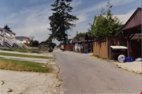
Looking west along the back lane
https://search.heritageburnaby.ca/link/archivedescription91860
- Repository
- City of Burnaby Archives
- Date
- June 1994
- Collection/Fonds
- Small family fonds
- Description Level
- Item
- Physical Description
- 1 photograph : col. copy print ; 10 cm x 15 cm
- Scope and Content
- Photograph of the back lane between Dominion Street and Norfolk Street, looking west. The fir tree in the centre of the photograph is one of many planted by John Roberts along the south property line of 5538 Dominion Street. The other trees were removed in 1982 when the Roberts' property was larg…
- Repository
- City of Burnaby Archives
- Date
- June 1994
- Collection/Fonds
- Small family fonds
- Physical Description
- 1 photograph : col. copy print ; 10 cm x 15 cm
- Description Level
- Item
- Record No.
- 620-041
- Access Restriction
- No restrictions
- Reproduction Restriction
- No reproduction permitted
- Accession Number
- 2017-01
- Scope and Content
- Photograph of the back lane between Dominion Street and Norfolk Street, looking west. The fir tree in the centre of the photograph is one of many planted by John Roberts along the south property line of 5538 Dominion Street. The other trees were removed in 1982 when the Roberts' property was largely cleared in order to relocate the house 100 feet west and subdivide the property into 33 foot lots.
- Subjects
- Geographic Features - Lanes
- Media Type
- Photograph
- Notes
- Transcribed title
- Title transcribed from donor's notes
- Note in blue ink on verso of photograph reads: "P.4"
- Note in blue ink on verso of photograph reads: "The Back lane behind 3131 Douglas Rd to 5496 etc Dominion St. / June 1994"
- 5118 Douglas Road renumbered to 3131 Douglas Road in 1958 and to 5538 Dominion Street in 1970 or 1971
- Street Address
- 3131 Douglas Road
- 5118 Douglas Road
- 5538 Dominion Street
- Historic Neighbourhood
- Burnaby Lake (Historic Neighbourhood)
- Planning Study Area
- Ardingley-Sprott Area
Images

Love family fonds
https://search.heritageburnaby.ca/link/museumdescription10098
- Repository
- Burnaby Village Museum
- Date
- 1881-1971
- Collection/Fonds
- Love family fonds
- Description Level
- Fonds
- Physical Description
- 11 cm of textual records + 44 photographs + 5 plans
- Scope and Content
- Fonds consists of family records including photographs, land sale records, agreements and plans as well as estate records, vital event documentation and correspondence. Records pertain to members of the Love family including the Parkers, Hughes and Leonards. Fonds has been arranged in the followin…
- Repository
- Burnaby Village Museum
- Collection/Fonds
- Love family fonds
- Description Level
- Fonds
- Physical Description
- 11 cm of textual records + 44 photographs + 5 plans
- Scope and Content
- Fonds consists of family records including photographs, land sale records, agreements and plans as well as estate records, vital event documentation and correspondence. Records pertain to members of the Love family including the Parkers, Hughes and Leonards. Fonds has been arranged in the following series: 1) Love and Leonard land records 2) Love family vital events and correspondence 3) Love family photographs
- History
- Jesse Love was born in Swindon, England in 1847 and left England to work on a dairy farm in the Toronto area. While working on the farm in Toronto, he met Martha Leonard who he married in 1879. Martha was born on February 3, 1858 in Bedfordshire, England and had come to Canada with her parents George and Ann Leonard. While living in Toronto, Jesse and Martha had two children, George born March 22, 1880 and Annie Elizabeth on August 24, 1881. About one year after Annie was born, the Love family moved to North Dakota to grow wheat. While living there, they had two more children, Henry who was born August 24, 1883 and Edith Minnie born October 9, 1885. The family decided to move further west after hearing about the fairer weather conditions from Martha’s father, George Leonard, who had settled in Vancouver in 1885. On May 23, 1887, Jesse, Martha and their four children arrived in Vancouver after travelling across Canada from Winnipeg on the first transcontinental train. The Loves made their home in Vancouver while Jesse helped clear land on Granville Street. Their fifth child, Thomas Robert was born on September 17, 1887 and soon after, the family moved to Lulu Island in Richmond where they lived growing vegetables and selling them to Vancouver hotels. While living and farming on Lulu island, the couple had two more girls, Martha (Dot or Dorothy) born on December 17, 1889 and Sarah Marie, born February 8, 1892. On October 6, 1893 an agreement was signed by Jesse Love to purchase 14.52 acres of land from Joseph C. Armstrong. The acreage covered the north east section of District Lot 25 within the newly incorporated District of the Municipality of Burnaby. It was here where the original Love house was built (between October 1893 and April 15, 1894) by Jesse Love with the help of local builder George Salt and father in law, George Leonard. The house consisted of an entrance hall, dining room, lean to kitchen, master bedroom and three bedrooms upstairs. A road was constructed and named Cumberland in 1905 and ran from District Lot 25 through to District Lot 11. The address for the Love home was 1390 Cumberland Road and in the early 1960’s the address was renumbered 7651 Cumberland Street. On the land surrounding the house, Jesse Love planted an orchard along with strawberries and raspberries which he sold at the Fraser Valley Market, T.S. Anandale’s Grocery Store in New Westminster and to hotels around Vancouver. Jesse Love served on the Burnaby School Board and also as a District Councillor in 1901 and from 1904-1907. While living in the house, Jesse and Martha had four more children, Phoebe Leonard, born April 15, 1894, Esther, born August 28, 1896, John Leonard, born June 7, 1899 and Hannah Victoria (also known as Girlie) who was born May 12, 1902. In 1918, at the age of 31 years, Thomas Robert Love fell ill due to an influenza epidemic and died on November 23, 1918. Following their son’s death, Martha Love became weak and on August 24, 1920, she passed away. By this time, Jesse had sold off a large percentage of his land and his youngest daughter, Girlie decided to stay on to live and care for him. Since the house was too large for just the two of them, Jesse invited any other children to return and share the residence. For a while his son, George and his wife joined them. In 1925 Jesse’s daughter Sarah Parker (nee Love), her husband William Michael Norton Parker and their three children, Albert “Bert” (1915-2011), William Charles “Bill” and Elsie Roberta moved from their home at 1319 Newcombe Street to join Jesse and Girlie in the Love family home on Cumberland. Jesse Love died in 1928 after which Sarah and William Parker purchased the Love family farmhouse and property. William Michael Parker, died in 1961 and Sarah Parker continued to live in the Love family farmhouse until 1966 when she sold it to her daughter Elsie and husband John Hughes. Elsie and John Hughes had four children, John Jr., Ann, Brent and Merle. The Hughes lived in the Love family house until August 1971. In 1988 the Love family farmhouse house was donated to the Burnaby Village Museum and moved to the site of Burnaby Village Museum. The interior of the main floor and exterior of the house went through an extensive restoration process. In 1997, restoration of the kitchen was completed and opened to the public. After the completion of the hallway, dining room, main floor bedroom and parlour, the Love farmhouse exhibit opened on November 29, 1998 with an open invitation to the public and extended members of the Love family.
- Responsibility
- Love Family
- Accession Code
- HV979.40
- BV985.3136
- BV988.45
- BV989.3
- BV992.15
- BV992.26
- BV992.34
- BV000.45
- BV008.20
- BV012.31
- BV019.3
- BV019.8
- Date
- 1881-1971
- Media Type
- Textual Record
- Photograph
- Cartographic Material
- Arrangement
- Fonds has been arranged by record type and original order provided by members of the Love family.
- Notes
- Title based on contents of fonds
- See also Burnaby Village Museum fonds - Jesse Love farmhouse series
Pursue a Desire for Additional Tree Planting Rezoning Reference #47/92 3700 Gilmore Way
https://search.heritageburnaby.ca/link/councilreport9898
- Repository
- City of Burnaby Archives
- Report ID
- 5577
- Meeting Date
- 25-Jan-1993
- Format
- Council - Manager's Report
- Manager's Report No.
- 6
- Item No.
- 22
- Collection/Fonds
- City Council and Office of the City Clerk fonds
- Repository
- City of Burnaby Archives
- Report ID
- 5577
- Meeting Date
- 25-Jan-1993
- Format
- Council - Manager's Report
- Manager's Report No.
- 6
- Item No.
- 22
- Collection/Fonds
- City Council and Office of the City Clerk fonds
Documents
Roja Bakhsh and Krystal Kuznecov
https://search.heritageburnaby.ca/link/archivedescription79238
- Repository
- City of Burnaby Archives
- Date
- May 22, 1996
- Collection/Fonds
- Burnaby NewsLeader photograph collection
- Description Level
- Item
- Physical Description
- 1 photograph : b&w ; 16 x 24 cm
- Scope and Content
- Photograph of Roja Bakhsh and Krystal Kuznecov planting a tree at Forest Grove elementary school.
- Repository
- City of Burnaby Archives
- Date
- May 22, 1996
- Collection/Fonds
- Burnaby NewsLeader photograph collection
- Physical Description
- 1 photograph : b&w ; 16 x 24 cm
- Description Level
- Item
- Record No.
- 535-0305
- Access Restriction
- No restrictions
- Reproduction Restriction
- No reproduction permitted
- Accession Number
- 2012-11
- Scope and Content
- Photograph of Roja Bakhsh and Krystal Kuznecov planting a tree at Forest Grove elementary school.
- Media Type
- Photograph
- Photographer
- Bartel, Mario
- Notes
- Title based on contents of photograph
- Note in black ink on recto of photograph reads: "5/22 Bby - p. 1 79%"
- Trim marks and/or reproduction instructions on recto (scan is cropped)
Images

Small family fonds
https://search.heritageburnaby.ca/link/archivedescription91819
- Repository
- City of Burnaby Archives
- Date
- 1922-2016
- Collection/Fonds
- Small family fonds
- Description Level
- Fonds
- Physical Description
- 75 photographs : b&w & col. + 1 plan
- Scope and Content
- Fonds consists of photographs documenting the transformation of the Burnaby Lake area of Burnaby, B.C. from semi-rural in the 1920s to urbanized in 2016. Photographs depict the land and houses located on the corner of Douglas Road and Dominion Street as the property was rezoned and its density quad…
- Repository
- City of Burnaby Archives
- Date
- 1922-2016
- Collection/Fonds
- Small family fonds
- Physical Description
- 75 photographs : b&w & col. + 1 plan
- Description Level
- Fonds
- Access Restriction
- Open access
- Reproduction Restriction
- May be restricted by third party rights
- Accession Number
- 2017-01
- Scope and Content
- Fonds consists of photographs documenting the transformation of the Burnaby Lake area of Burnaby, B.C. from semi-rural in the 1920s to urbanized in 2016. Photographs depict the land and houses located on the corner of Douglas Road and Dominion Street as the property was rezoned and its density quadrupled. Fonds also includes photographs of the Small family house being moved to 5496 Dominion Street and the original landscape plan for 5118 Douglas Road.
- History
- In 1915, John W. Roberts and his wife Mary Allen Roberts moved from the United States to Canada along with their daughter, Lauretta. On first moving to Canada, the family lived in a rented house in Vancouver and John worked as a movie projectionist in the city. The couple had three more children, all sons: John A., Edward, and Roland. Circa 1921, John purchased a large parcel of land at the corner of Douglas Road and Dominion Street in Burnaby. This parcel encompassed the equivalent of at least six 66-foot lots along the south side of Dominion Street and the same along the north side of Norfolk Street. On their property, a barn and small living quarters were built. The family moved in, raising goats and growing potatoes to supplement their income. They also planted cherry, apple, and pear trees; hazelnut and walnut trees; raspberries; and a large vegetable garden, the fruits of which Mary preserved for year-round use. At this time, agricultural activities were common for families in the area: the Roberts' neighbours kept chickens for personal use and for selling eggs; grew mushrooms for commercial sale; and sold manure from an old buckboard drawn by Clydesdale horses. John built a new house in the middle of the Roberts’ lots on the southwest corner of Douglas Road and Dominion Street. The house faced Douglas Road and overlooked a large, well-landscaped front yard to the east and a full-sized, clay tennis court to the north. The family moved into this new house in 1925. When the Roberts ceased raising goats, the barn and original living quarters were reduced to a double-car garage with storage space plus a sawdust-insulated “root cellar”. John also built a house on the northwest corner of the lot at Douglas Road and Dominion Street (3093 Douglas Road), which was purchased by the Hardy family. In 1957, part of this property (3071 Douglas Road) was sold to the Brocklebanks who built a house and lived there. In addition, John built a house at the northwest corner of Douglas Road and Norfolk Street (5106 Douglas Road). The original purchaser of this house is unknown, but in 1949, it was bought by the Meyers family. In 1952 or 1953, the Meyers sold part of this property and the Manahans built a house on it, facing Douglas Road. Several other lots that John owned were also sold off over the years. By the 1950s, John owned only five 66-foot lots from Douglas Road west, along the south side Dominion Street. In 1954, John sold the lot furthest from Douglas Road (5486 Dominion Street) to a builder who built a “ranch-style” house and put it up for sale. John retired from his career as a movie projectionist in the 1950s. He, Mary, and Lauretta retained their US citizenship all their lives, although they never returned to the USA except for brief visits. John A., Edward, and Roland who, as children of US citizens, also had US citizenship, eventually moved to the US, where they remained for the rest of their lives. In 1945, Lauretta married Frederick Small. The couple lived in a rented house in Vancouver for a few years before moving in with John and Mary in Burnaby. The couple had four children: Elizabeth, Kathryn, Charles, and Martin. In 1955, Frederick purchased the rancher at 5486 Dominion Street and the family moved in. The Small children grew up enjoying the freedom of having their grandparent’s large property in addition to their parent’s yard to play in. The back lane that ran between Dominion Street and Norfolk Street was filled with trees and bushes, creating a narrow bit of “forest” to explore. In 1957, John died. Mary died in 1969, as did Frederick. Lauretta was executor for her mother’s and husband’s estates. After much consideration, she decided to sell the house at 5486 Dominion Street and move back into her childhood home. By doing so, she was able to settle her mother’s estate to the satisfaction of her brothers. Elizabeth married and moved away. Over the next few years, the “Roberts” house was home to Lauretta, Kathryn, Charles, and Martin, with the three grown children moving in and out several times during the 1970s. In 1981, Lauretta died. Her children discussed at length how to divide up the property, which consisted of four 66-foot lots, according to her will. None of her children wanted to see the old family house destroyed but the house straddled two lots. They finally decided that if one of them wanted to pay to move the house to sit on one of the lots, the “value” of the house would not enter into the settlement of the estate. Kathryn chose to do this. In 1982, the old house was moved to 5496 Dominion Street and Kathryn continued to live in it. Martin died in 1982. Elizabeth and Charles each inherited one lot and the last lot, which would have gone to Martin, was sold, the funds divided equally between Elizabeth, Kathryn, and Charles. The three lots between 5496 Dominion Street and Douglas Road were subdivided into 33-foot lots and six new houses were built. In 1993, the Meyers property and the Manahan property were subdivided into 33-foot lots facing Norfolk Street and the old houses were torn down and four new houses were built.
- Media Type
- Photograph
- Technical Drawing
- Creator
- Small family
Society correspondence
https://search.heritageburnaby.ca/link/archivedescription98390
- Repository
- City of Burnaby Archives
- Date
- 1992-1994
- Collection/Fonds
- Burnaby Historical Society fonds
- Description Level
- File
- Physical Description
- 0.5 cm of textual records
- Scope and Content
- File contains Burnaby Historical Society correspondence. Correspondence predominantly pertains to donations made to the City for a commemorative picnic table and planting in honour of Blythe and Violet Eagles and re-installation of the Jubilee Arch plaque among other Society projects. File also i…
- Repository
- City of Burnaby Archives
- Date
- 1992-1994
- Collection/Fonds
- Burnaby Historical Society fonds
- Series
- Administration series
- Physical Description
- 0.5 cm of textual records
- Description Level
- File
- Record No.
- MSS205-066
- Access Restriction
- No restrictions
- Accession Number
- 2020-06
- Scope and Content
- File contains Burnaby Historical Society correspondence. Correspondence predominantly pertains to donations made to the City for a commemorative picnic table and planting in honour of Blythe and Violet Eagles and re-installation of the Jubilee Arch plaque among other Society projects. File also includes news release copy, the September 1993 Volume 1 No. 1 issues of the Society's newsletter, and a "Capsule History of the Burnaby Historical Society" written by Pixie McGeachie.
- Media Type
- Textual Record
- Notes
- Title based on contents of file
- Original file folder titled: "1992, 1993, 1994"
Still Creek Buffer Planting - Rezoning Reference #14/94 - 4401 Still Creek Drive - Willingdon Park Community Plan
https://search.heritageburnaby.ca/link/councilreport6097
- Repository
- City of Burnaby Archives
- Report ID
- 61074
- Meeting Date
- 27-Oct-1997
- Format
- Council - Manager's Report
- Manager's Report No.
- 27
- Item No.
- 1
- Collection/Fonds
- City Council and Office of the City Clerk fonds
- Repository
- City of Burnaby Archives
- Report ID
- 61074
- Meeting Date
- 27-Oct-1997
- Format
- Council - Manager's Report
- Manager's Report No.
- 27
- Item No.
- 1
- Collection/Fonds
- City Council and Office of the City Clerk fonds
Documents
Tree Planting on Hastings/Gaglardi Connector and Canada Way/Edmonds Project
https://search.heritageburnaby.ca/link/councilreport9165
- Repository
- City of Burnaby Archives
- Report ID
- 6088
- Meeting Date
- 29-Nov-1993
- Format
- Council - Manager's Report
- Manager's Report No.
- 70
- Item No.
- 16
- Collection/Fonds
- City Council and Office of the City Clerk fonds
- Repository
- City of Burnaby Archives
- Report ID
- 6088
- Meeting Date
- 29-Nov-1993
- Format
- Council - Manager's Report
- Manager's Report No.
- 70
- Item No.
- 16
- Collection/Fonds
- City Council and Office of the City Clerk fonds
Documents
William Holmes family records series
https://search.heritageburnaby.ca/link/museumdescription18942
- Repository
- Burnaby Village Museum
- Date
- 1858-1941
- Collection/Fonds
- William Holmes fonds
- Description Level
- Series
- Physical Description
- 5 p. textual records + 1 newspaper clipping
- Scope and Content
- Series consists of letters and land title certificates of William Holmes along with a newspaper clipping refering to the European Ash tree that was planted by the Holmes family on their land in District Lot 1 in Burnaby.
- Repository
- Burnaby Village Museum
- Collection/Fonds
- William Holmes fonds
- Description Level
- Series
- Physical Description
- 5 p. textual records + 1 newspaper clipping
- Scope and Content
- Series consists of letters and land title certificates of William Holmes along with a newspaper clipping refering to the European Ash tree that was planted by the Holmes family on their land in District Lot 1 in Burnaby.
- Accession Code
- BV997.50
- Date
- 1858-1941
- Media Type
- Textual Record
- Notes
- Title based on contents of series