Narrow Results By
Subject
- Agriculture - Crops 2
- Agriculture - Farms 8
- Animals - Dogs 6
- Animals - Horses 1
- Buildings - Agricultural - Barns 5
- Buildings - Commercial - Stores 2
- Buildings - Heritage 13
- Buildings - Residential 8
- Buildings - Residential - Houses 119
- Buildings - Residential - Palaces 1
- Construction 2
- Documentary Artifacts - Books 1
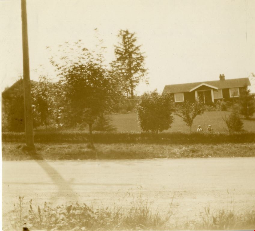
![Jackson family, [193-] (date of original), copied 1992 thumbnail](/media/hpo/_Data/_Archives_Images/_Unrestricted/315/315-099.jpg?width=280)
Jackson family
https://search.heritageburnaby.ca/link/archivedescription36744
- Repository
- City of Burnaby Archives
- Date
- [193-] (date of original), copied 1992
- Collection/Fonds
- Burnaby Historical Society fonds
- Description Level
- Item
- Physical Description
- 1 photograph : b&w ; 8.7 x 12.6 cm print
- Scope and Content
- Photograph of sister and brother, Vera and Ron Jackson, in the snow with two dogs.
- Repository
- City of Burnaby Archives
- Date
- [193-] (date of original), copied 1992
- Collection/Fonds
- Burnaby Historical Society fonds
- Subseries
- Burnaby Centennial Anthology subseries
- Physical Description
- 1 photograph : b&w ; 8.7 x 12.6 cm print
- Description Level
- Item
- Record No.
- 315-099
- Access Restriction
- No restrictions
- Reproduction Restriction
- No known restrictions
- Accession Number
- BHS1994-04
- Scope and Content
- Photograph of sister and brother, Vera and Ron Jackson, in the snow with two dogs.
- Media Type
- Photograph
- Notes
- Title based on contents of photograph
Images
![Jackson family, [193-] (date of original), copied 1992 thumbnail](/media/hpo/_Data/_Archives_Images/_Unrestricted/315/315-099.jpg)

John McCallum at Nicholson Farm
https://search.heritageburnaby.ca/link/archivedescription38260
- Repository
- City of Burnaby Archives
- Date
- 1931
- Collection/Fonds
- Burnaby Historical Society fonds
- Description Level
- Item
- Physical Description
- 1 photograph : b&w ; 10.4 x 15.4 cm
- Scope and Content
- Photograph of three men and a team of horses standing in a field next to the home and farm belonging to E.W. Nicholson.
- Repository
- City of Burnaby Archives
- Date
- 1931
- Collection/Fonds
- Burnaby Historical Society fonds
- Subseries
- Margaret McCallum subseries
- Physical Description
- 1 photograph : b&w ; 10.4 x 15.4 cm
- Description Level
- Item
- Record No.
- 375-022
- Access Restriction
- No restrictions
- Reproduction Restriction
- No known restrictions
- Accession Number
- BHS1986-42
- Scope and Content
- Photograph of three men and a team of horses standing in a field next to the home and farm belonging to E.W. Nicholson.
- Media Type
- Photograph
- Notes
- Title based on caption
- A note on the back of the photograph reads: "Home of E.W. Nicholson. John McCallum and team. George Dell near steps."
- Geographic Access
- Boundary Road
- Street Address
- 2550 Boundary Road
- Historic Neighbourhood
- Broadview (Historic Neighbourhood)
- Planning Study Area
- West Central Valley Area
Images

![Kask family home, [193-] (date of original), copied 1991 thumbnail](/media/hpo/_Data/_Archives_Images/_Unrestricted/370/370-002.jpg?width=280)
Kask family home
https://search.heritageburnaby.ca/link/archivedescription37414
- Repository
- City of Burnaby Archives
- Date
- [193-] (date of original), copied 1991
- Collection/Fonds
- Burnaby Historical Society fonds
- Description Level
- Item
- Physical Description
- 1 photograph : b&w ; 3.3 x 5.6 cm print on contact sheet 20.2 x 25.4 cm
- Scope and Content
- Photograph of the Kask family home at Kask Camp. Sitting on the porch, left to right, are; Jennie Kask, David Kask, Jack Kask, and Volya.
- Repository
- City of Burnaby Archives
- Date
- [193-] (date of original), copied 1991
- Collection/Fonds
- Burnaby Historical Society fonds
- Subseries
- Burnaby Image Bank subseries
- Physical Description
- 1 photograph : b&w ; 3.3 x 5.6 cm print on contact sheet 20.2 x 25.4 cm
- Description Level
- Item
- Record No.
- 370-002
- Access Restriction
- No restrictions
- Reproduction Restriction
- No known restrictions
- Accession Number
- BHS1999-03
- Scope and Content
- Photograph of the Kask family home at Kask Camp. Sitting on the porch, left to right, are; Jennie Kask, David Kask, Jack Kask, and Volya.
- Subjects
- Buildings - Residential - Houses
- Media Type
- Photograph
- Notes
- Title based on contents of photograph
- 1 b&w copy negative accompanying
- Geographic Access
- Barnet Road
- Street Address
- 7501 Barnet Road
- Historic Neighbourhood
- Barnet (Historic Neighbourhood)
- Planning Study Area
- Burnaby Mountain Area
Images
![Kask family home, [193-] (date of original), copied 1991 thumbnail](/media/hpo/_Data/_Archives_Images/_Unrestricted/370/370-002.jpg)
Kneale family home
https://search.heritageburnaby.ca/link/archivedescription36939
- Repository
- City of Burnaby Archives
- Date
- 1930 (date of original), copied 1992
- Collection/Fonds
- Burnaby Historical Society fonds
- Description Level
- Item
- Physical Description
- 1 photograph : b&w ; 8.7 x 12.7 cm print
- Scope and Content
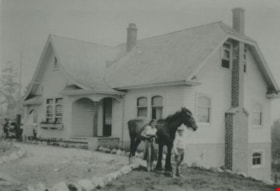
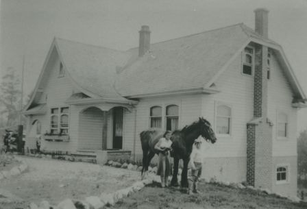
- Photograph of the exterior of the Kneale family home at 6726 Broadway (at Sperling Avenue). A woman, boy and horse are standing in front of the house together.
- Repository
- City of Burnaby Archives
- Date
- 1930 (date of original), copied 1992
- Collection/Fonds
- Burnaby Historical Society fonds
- Subseries
- Burnaby Centennial Anthology subseries
- Physical Description
- 1 photograph : b&w ; 8.7 x 12.7 cm print
- Description Level
- Item
- Record No.
- 315-397
- Access Restriction
- No restrictions
- Reproduction Restriction
- No known restrictions
- Accession Number
- BHS1994-04
- Scope and Content
- Photograph of the exterior of the Kneale family home at 6726 Broadway (at Sperling Avenue). A woman, boy and horse are standing in front of the house together.
- Media Type
- Photograph
- Notes
- Title based on contents of photograph
- Geographic Access
- Broadway
- Street Address
- 6726 Broadway
- Historic Neighbourhood
- Lochdale (Historic Neighbourhood)
- Planning Study Area
- Sperling-Broadway Area
Images
Langford family home
https://search.heritageburnaby.ca/link/archivedescription37014
- Repository
- City of Burnaby Archives
- Date
- 1931 (date of original), copied 1992
- Collection/Fonds
- Burnaby Historical Society fonds
- Description Level
- Item
- Physical Description
- 1 photograph : b&w ; 8.7 x 12.6 cm print
- Scope and Content
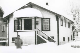
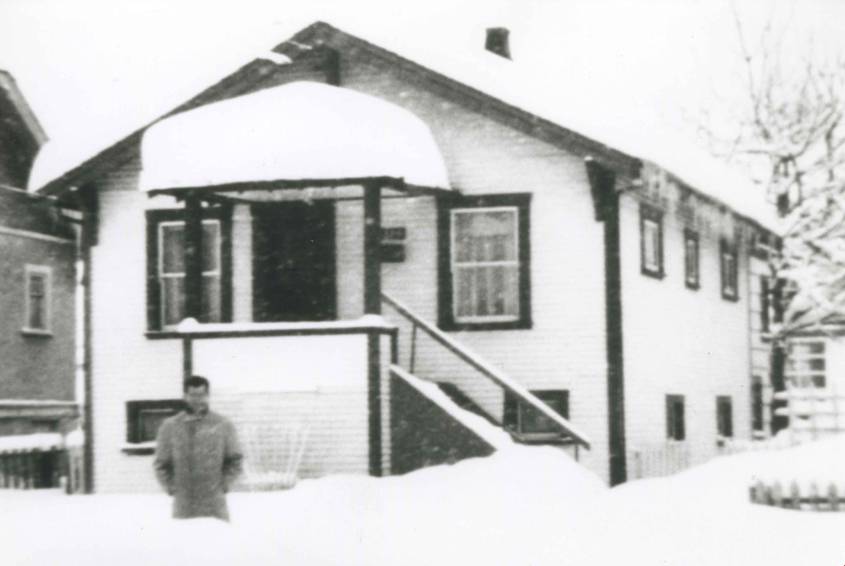
- Photograph of the Langford family home at 3509 Barker Avenue (one door south of Kingsway) in the snow. A man is standing in front.
- Repository
- City of Burnaby Archives
- Date
- 1931 (date of original), copied 1992
- Collection/Fonds
- Burnaby Historical Society fonds
- Subseries
- Burnaby Centennial Anthology subseries
- Physical Description
- 1 photograph : b&w ; 8.7 x 12.6 cm print
- Description Level
- Item
- Record No.
- 315-477
- Access Restriction
- No restrictions
- Reproduction Restriction
- No known restrictions
- Accession Number
- BHS1994-04
- Scope and Content
- Photograph of the Langford family home at 3509 Barker Avenue (one door south of Kingsway) in the snow. A man is standing in front.
- Media Type
- Photograph
- Notes
- Title based on contents of photograph
- Geographic Access
- Barker Avenue
- Kingsway
- Street Address
- 5806 Barker Avenue
- Historic Neighbourhood
- Central Park (Historic Neighbourhood)
- Planning Study Area
- Maywood Area
Images
![Lewarne family home, [1933] (date of original), copied 1986 thumbnail](/media/hpo/_Data/_Archives_Images/_Unrestricted/204/204-053.jpg?width=280)
Lewarne family home
https://search.heritageburnaby.ca/link/archivedescription35196
- Repository
- City of Burnaby Archives
- Date
- [1933] (date of original), copied 1986
- Collection/Fonds
- Burnaby Historical Society fonds
- Description Level
- Item
- Physical Description
- 1 photograph : b&w ; 12.7 x 20.3 cm print
- Scope and Content
- Photograph of Lewarne family home on Nelson Avenue in Alta Vista.
- Repository
- City of Burnaby Archives
- Date
- [1933] (date of original), copied 1986
- Collection/Fonds
- Burnaby Historical Society fonds
- Subseries
- Pioneer Tales subseries
- Physical Description
- 1 photograph : b&w ; 12.7 x 20.3 cm print
- Description Level
- Item
- Record No.
- 204-053
- Access Restriction
- No restrictions
- Reproduction Restriction
- No known restrictions
- Accession Number
- BHS1988-03
- Scope and Content
- Photograph of Lewarne family home on Nelson Avenue in Alta Vista.
- Subjects
- Buildings - Residential - Houses
- Media Type
- Photograph
- Notes
- Title based on contents of photograph
- Geographic Access
- Nelson Avenue
- Historic Neighbourhood
- Alta-Vista (Historic Neighbourhood)
- Planning Study Area
- Sussex-Nelson Area
Images
![Lewarne family home, [1933] (date of original), copied 1986 thumbnail](/media/hpo/_Data/_Archives_Images/_Unrestricted/204/204-053.jpg)
![Looking east from north side of 5118 Douglas Road - The Roberts House, [1931] thumbnail](/media/hpo/_Data/_Archives_Images/_Unrestricted/600/620-004.jpg?width=280)
Looking east from north side of 5118 Douglas Road - The Roberts House
https://search.heritageburnaby.ca/link/archivedescription91823
- Repository
- City of Burnaby Archives
- Date
- [1931]
- Collection/Fonds
- Small family fonds
- Description Level
- Item
- Physical Description
- 1 photograph : sepia ; 8.5 cm x 8.5 cm
- Scope and Content
- Photograph of the Roberts' children: Lauretta, John A., Edward, and Roland. The children are posed with a bicycle in the Roberts' yard, which is in the process of being landscaped. The house at 3090 Douglas Road (left) and the Adams' family house at 3011 Godwin (right) are visible in the backgrou…
- Repository
- City of Burnaby Archives
- Date
- [1931]
- Collection/Fonds
- Small family fonds
- Physical Description
- 1 photograph : sepia ; 8.5 cm x 8.5 cm
- Description Level
- Item
- Record No.
- 620-004
- Access Restriction
- No restrictions
- Reproduction Restriction
- No known restrictions
- Accession Number
- 2017-01
- Scope and Content
- Photograph of the Roberts' children: Lauretta, John A., Edward, and Roland. The children are posed with a bicycle in the Roberts' yard, which is in the process of being landscaped. The house at 3090 Douglas Road (left) and the Adams' family house at 3011 Godwin (right) are visible in the background. The photograph was taken from the north side of the Roberts' property at 5118 Douglas Road.
- Media Type
- Photograph
- Notes
- Transcribed title
- Title transcribed from donor's notes
- 5118 Douglas Road renumbered to 3131 Douglas Road in 1958 and to 5538 Dominion Street in 1970 or 1971
- 3011 Godwin is a new address. Previous address was on the 5100 block of Douglas Road (house number unknown).
- Note in blue ink on verso of photograph reads: "1930? or '31 / Roberts children / Lauretta John A. Edward / Roland"
- Note in blue ink on verso of photograph reads: "P5"
- See landscape plan for 5118 Douglas Road
- Street Address
- 3131 Douglas Road
- 5118 Douglas Road
- 5538 Dominion Street
- 3090 Douglas Road
- 3011 Godwin Avenue
- Historic Neighbourhood
- Burnaby Lake (Historic Neighbourhood)
- Planning Study Area
- Ardingley-Sprott Area
Images
![Looking east from north side of 5118 Douglas Road - The Roberts House, [1931] thumbnail](/media/hpo/_Data/_Archives_Images/_Unrestricted/600/620-004.jpg)

Looking west from Douglas Road
https://search.heritageburnaby.ca/link/archivedescription91827
- Repository
- City of Burnaby Archives
- Date
- September 1934
- Collection/Fonds
- Small family fonds
- Description Level
- Item
- Physical Description
- 1 photograph : sepia ; 7.5 cm x 8.5 cm
- Scope and Content
- Photograph of the Roberts' house on 5118 Douglas Road, taken from across the street. Edward and Roland Roberts are seated on the lawn behind a hedge and in front of the house. To the left is the house located at 5106 Douglas Road, built by John W. Roberts and then subsequently sold.
- Repository
- City of Burnaby Archives
- Date
- September 1934
- Collection/Fonds
- Small family fonds
- Physical Description
- 1 photograph : sepia ; 7.5 cm x 8.5 cm
- Description Level
- Item
- Record No.
- 620-008
- Access Restriction
- No restrictions
- Reproduction Restriction
- No known restrictions
- Accession Number
- 2017-01
- Scope and Content
- Photograph of the Roberts' house on 5118 Douglas Road, taken from across the street. Edward and Roland Roberts are seated on the lawn behind a hedge and in front of the house. To the left is the house located at 5106 Douglas Road, built by John W. Roberts and then subsequently sold.
- Media Type
- Photograph
- Notes
- Transcribed title
- Title transcribed from donor's notes
- 5118 Douglas Road renumbered to 3131 Douglas Road in 1958 and to 5538 Dominion Street in 1970 or 1971
- 5106 Douglas Road later subdivided into 5539 and 5545 Norfolk Street.
- Note in black ink on verso of photograph reads: "Sept. 1934 / Our house on Douglas Road"
- Note in blue ink on verso of photograph reads: "P9"
- Street Address
- 3131 Douglas Road
- 5118 Douglas Road
- 5538 Dominion Street
- 5106 Douglas Road
- Historic Neighbourhood
- Burnaby Lake (Historic Neighbourhood)
- Planning Study Area
- Ardingley-Sprott Area
Images
![Lubbock farmhouse, [1935] thumbnail](/media/hpo/_Data/_Archives_Images/_Unrestricted/316/342-001.jpg?width=280)
Lubbock farmhouse
https://search.heritageburnaby.ca/link/archivedescription37227
- Repository
- City of Burnaby Archives
- Date
- [1935]
- Collection/Fonds
- Burnaby Historical Society fonds
- Description Level
- Item
- Physical Description
- 1 photograph : sepia ; 5.5 x 8 cm
- Scope and Content
- Photograph of the exterior of the Lubbock farmhouse at Canada Way and Burris.
- Repository
- City of Burnaby Archives
- Date
- [1935]
- Collection/Fonds
- Burnaby Historical Society fonds
- Subseries
- Lubbock family subseries
- Physical Description
- 1 photograph : sepia ; 5.5 x 8 cm
- Description Level
- Item
- Record No.
- 342-001
- Access Restriction
- No restrictions
- Reproduction Restriction
- No known restrictions
- Accession Number
- BHS1994-02
- Scope and Content
- Photograph of the exterior of the Lubbock farmhouse at Canada Way and Burris.
- Media Type
- Photograph
- Notes
- Title based on contents of photograph
- Geographic Access
- Grandview Highway
- Canada Way
- Burris Street
- Street Address
- 7803 Burris Street
- Historic Neighbourhood
- Burnaby Lake (Historic Neighbourhood)
- Planning Study Area
- Morley-Buckingham Area
Images
![Lubbock farmhouse, [1935] thumbnail](/media/hpo/_Data/_Archives_Images/_Unrestricted/316/342-001.jpg)
![Lubbock farmhouse, [1935] thumbnail](/media/hpo/_Data/_Archives_Images/_Unrestricted/316/342-002.jpg?width=280)
Lubbock farmhouse
https://search.heritageburnaby.ca/link/archivedescription37228
- Repository
- City of Burnaby Archives
- Date
- [1935]
- Collection/Fonds
- Burnaby Historical Society fonds
- Description Level
- Item
- Physical Description
- 1 photograph : sepia ; 5.5 x 8 cm
- Scope and Content
- Photograph of the Lubbock family farmhouse at Burris Street and Canada Way.
- Repository
- City of Burnaby Archives
- Date
- [1935]
- Collection/Fonds
- Burnaby Historical Society fonds
- Subseries
- Lubbock family subseries
- Physical Description
- 1 photograph : sepia ; 5.5 x 8 cm
- Description Level
- Item
- Record No.
- 342-002
- Access Restriction
- No restrictions
- Reproduction Restriction
- No known restrictions
- Accession Number
- BHS1994-02
- Scope and Content
- Photograph of the Lubbock family farmhouse at Burris Street and Canada Way.
- Media Type
- Photograph
- Notes
- Title based on contents of photograph
- Geographic Access
- Grandview Highway
- Canada Way
- Burris Street
- Street Address
- 7803 Burris Street
- Historic Neighbourhood
- Burnaby Lake (Historic Neighbourhood)
- Planning Study Area
- Morley-Buckingham Area
Images
![Lubbock farmhouse, [1935] thumbnail](/media/hpo/_Data/_Archives_Images/_Unrestricted/316/342-002.jpg)
![Lubbock farmhouse, [1935] thumbnail](/media/hpo/_Data/_Archives_Images/_Unrestricted/316/342-003.jpg?width=280)
Lubbock farmhouse
https://search.heritageburnaby.ca/link/archivedescription37229
- Repository
- City of Burnaby Archives
- Date
- [1935]
- Collection/Fonds
- Burnaby Historical Society fonds
- Description Level
- Item
- Physical Description
- 1 photograph : sepia ; 5.5 x 8 cm
- Scope and Content
- Photograph of the Lubbock family farmhouse and garden at Burris Street and Canada Way.
- Repository
- City of Burnaby Archives
- Date
- [1935]
- Collection/Fonds
- Burnaby Historical Society fonds
- Subseries
- Lubbock family subseries
- Physical Description
- 1 photograph : sepia ; 5.5 x 8 cm
- Description Level
- Item
- Record No.
- 342-003
- Access Restriction
- No restrictions
- Reproduction Restriction
- No known restrictions
- Accession Number
- BHS1994-02
- Scope and Content
- Photograph of the Lubbock family farmhouse and garden at Burris Street and Canada Way.
- Media Type
- Photograph
- Notes
- Title based on contents of photograph
- Geographic Access
- Grandview Highway
- Canada Way
- Burris Street
- Street Address
- 7803 Burris Street
- Historic Neighbourhood
- Burnaby Lake (Historic Neighbourhood)
- Planning Study Area
- Morley-Buckingham Area
Images
![Lubbock farmhouse, [1935] thumbnail](/media/hpo/_Data/_Archives_Images/_Unrestricted/316/342-003.jpg)

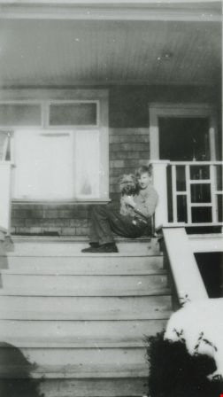
Lyle Le Grove and Dog
https://search.heritageburnaby.ca/link/archivedescription38053
- Repository
- City of Burnaby Archives
- Date
- Feb. 1933 (date of original), copied 1991
- Collection/Fonds
- Burnaby Historical Society fonds
- Description Level
- Item
- Physical Description
- 1 photograph : b&w ; 4.3 x 2.5 cm print on contact sheet 20.2 x 26.6 cm
- Scope and Content
- Photograph of Lyle Le Grove and a dog sitting on the steps outside of 3825 Hazel Street (later renumbered 4673 Hazel Street).
- Repository
- City of Burnaby Archives
- Date
- Feb. 1933 (date of original), copied 1991
- Collection/Fonds
- Burnaby Historical Society fonds
- Subseries
- Burnaby Image Bank subseries
- Physical Description
- 1 photograph : b&w ; 4.3 x 2.5 cm print on contact sheet 20.2 x 26.6 cm
- Description Level
- Item
- Record No.
- 370-640
- Access Restriction
- No restrictions
- Reproduction Restriction
- No known restrictions
- Accession Number
- BHS1999-03
- Scope and Content
- Photograph of Lyle Le Grove and a dog sitting on the steps outside of 3825 Hazel Street (later renumbered 4673 Hazel Street).
- Media Type
- Photograph
- Notes
- Title based on contents of photograph
- 1 b&w copy negative accompanying
- Negative has a pink cast
- Geographic Access
- Hazel Street
- Street Address
- 4673 Hazel Street
- Historic Neighbourhood
- Central Park (Historic Neighbourhood)
- Planning Study Area
- Marlborough Area
Images
![MacDonald house, [1930] thumbnail](/media/hpo/_Data/_Archives_Images/_Unrestricted/371/476-005.jpg?width=280)
MacDonald house
https://search.heritageburnaby.ca/link/archivedescription38662
- Repository
- City of Burnaby Archives
- Date
- [1930]
- Collection/Fonds
- Burnaby Historical Society fonds
- Description Level
- Item
- Physical Description
- 1 photograph : sepia ; 14.5 x 20.5 cm
- Scope and Content
- Photograph of the Angus and Margaret MacDonald house located at Oxford Street and Esmond Avenue. The MacDonald House is one of Burnaby’s landmark residential heritage buildings and was built in 1909 as part of the exclusive subdivision known as “Vancouver Heights.” The family came to Vancouver fro…
- Repository
- City of Burnaby Archives
- Date
- [1930]
- Collection/Fonds
- Burnaby Historical Society fonds
- Subseries
- North Burnaby Board of Trade subseries
- Physical Description
- 1 photograph : sepia ; 14.5 x 20.5 cm
- Description Level
- Item
- Record No.
- 476-005
- Access Restriction
- No restrictions
- Reproduction Restriction
- No known restrictions
- Accession Number
- BHS2005-8
- Scope and Content
- Photograph of the Angus and Margaret MacDonald house located at Oxford Street and Esmond Avenue. The MacDonald House is one of Burnaby’s landmark residential heritage buildings and was built in 1909 as part of the exclusive subdivision known as “Vancouver Heights.” The family came to Vancouver from Nova Scotia in 1891 and Angus MacDonald, an electrical contractor, served as a Councillor for the City of Vancouver from 1904-1908. Upon his retirement from the B.C. Electric Railway Company, he moved to Burnaby and was a prominent resident serving his North Burnaby ‘Ward’ as a Burnaby Councillor between 1911 and 1916. MacDonald Street in Burnaby was named in his honour. This house which cost $7,000 to construct is reputed to have been the second house built in the Vancouver Heights subdivision. After the death of Margaret MacDonald in 1939 and Angus MacDonald in 1941, the MacDonald family sold the house in 1944 to local grocer John R. and Anne Roane. In 1956, the property was purchased by the late Dr. John Alex MacDonald and his wife Violet E. MacDonald.
- Media Type
- Photograph
- Notes
- Title based on contents of photograph
- Geographic Access
- Oxford Street
- Esmond Avenue
- Street Address
- 3814 Oxford Street
- Historic Neighbourhood
- Vancouver Heights (Historic Neighbourhood)
- Planning Study Area
- Burnaby Heights Area
Images
![MacDonald house, [1930] thumbnail](/media/hpo/_Data/_Archives_Images/_Unrestricted/371/476-005.jpg)
![Manager's residence at Barnet Mill, [1935] (date of original), copied 2004 thumbnail](/media/hpo/_Data/_BVM_Images/2019/2019_0032_0059_001.jpg?width=280)
Manager's residence at Barnet Mill
https://search.heritageburnaby.ca/link/museumdescription15240
- Repository
- Burnaby Village Museum
- Date
- [1935] (date of original), copied 2004
- Collection/Fonds
- In the Shadow by the Sea collection
- Description Level
- Item
- Physical Description
- 1 photograph (tiff) : 300 dpi
- Scope and Content
- Photograph of the manager's residence at the Barnet Mill. Henry Stanley Irwin, his wife Elsie May, their children Eleanor and Louise and Elsie's mother, Elizabeth Taylor lived in this house between 1924 and 1939. A picket fence encloses the large yard with a garden and cherry trees. The forested sl…
- Repository
- Burnaby Village Museum
- Collection/Fonds
- In the Shadow by the Sea collection
- Description Level
- Item
- Physical Description
- 1 photograph (tiff) : 300 dpi
- Scope and Content
- Photograph of the manager's residence at the Barnet Mill. Henry Stanley Irwin, his wife Elsie May, their children Eleanor and Louise and Elsie's mother, Elizabeth Taylor lived in this house between 1924 and 1939. A picket fence encloses the large yard with a garden and cherry trees. The forested slope of Burnaby mountain is visible behind the house. The house, grounds and trees are covered with snow.
- Geographic Access
- Burrard Inlet
- Accession Code
- BV019.32.59
- Access Restriction
- No restrictions
- Reproduction Restriction
- No known restrictions
- Date
- [1935] (date of original), copied 2004
- Media Type
- Photograph
- Historic Neighbourhood
- Barnet (Historic Neighbourhood)
- Planning Study Area
- Burnaby Mountain Area
- Notes
- Title based on contents of photograph
Images
![Manager's residence at Barnet Mill, [1935] (date of original), copied 2004 thumbnail](/media/hpo/_Data/_BVM_Images/2019/2019_0032_0059_001.jpg)
![Manager's residence at Barnet Mill, [1935] (date of original), copied 2004 thumbnail](/media/hpo/_Data/_BVM_Images/2019/2019_0032_0060_001.jpg?width=280)
Manager's residence at Barnet Mill
https://search.heritageburnaby.ca/link/museumdescription15241
- Repository
- Burnaby Village Museum
- Date
- [1935] (date of original), copied 2004
- Collection/Fonds
- In the Shadow by the Sea collection
- Description Level
- Item
- Physical Description
- 1 photograph (tiff) : 300 dpi
- Scope and Content
- Photograph of the manager's residence at the Barnet Mill. Henry Stanley Irwin, his wife Elsie May, their children Eleanor and Louise and Elsie's mother, Elizabeth Taylor lived in this house between 1924 and 1939. A picket fence encloses the large yard with a garden and cherry trees. The forested sl…
- Repository
- Burnaby Village Museum
- Collection/Fonds
- In the Shadow by the Sea collection
- Description Level
- Item
- Physical Description
- 1 photograph (tiff) : 300 dpi
- Scope and Content
- Photograph of the manager's residence at the Barnet Mill. Henry Stanley Irwin, his wife Elsie May, their children Eleanor and Louise and Elsie's mother, Elizabeth Taylor lived in this house between 1924 and 1939. A picket fence encloses the large yard with a garden and cherry trees. The forested slope of Burnaby mountain is visible behind the house.
- Subjects
- Buildings - Residential - Houses
- Geographic Access
- Burrard Inlet
- Accession Code
- BV019.32.60
- Access Restriction
- No restrictions
- Reproduction Restriction
- No known restrictions
- Date
- [1935] (date of original), copied 2004
- Media Type
- Photograph
- Historic Neighbourhood
- Barnet (Historic Neighbourhood)
- Planning Study Area
- Burnaby Mountain Area
- Notes
- Title based on contents of photograph
Images
![Manager's residence at Barnet Mill, [1935] (date of original), copied 2004 thumbnail](/media/hpo/_Data/_BVM_Images/2019/2019_0032_0060_001.jpg)

Marine Drive Game Farm
https://search.heritageburnaby.ca/link/archivedescription35158
- Repository
- City of Burnaby Archives
- Date
- 1930 (date of original), copied 1986
- Collection/Fonds
- Burnaby Historical Society fonds
- Description Level
- Item
- Physical Description
- 1 photograph : b&w ; 12.7 x 17.8 cm print
- Scope and Content
- Photograph of the Marine Drive Game Farm, founded and owned by William "Bill" Greenslade's father, William Greenslade, Sr. It was located at 3295 Marine Drive (later renumbered 5421 Marine Drive).
- Repository
- City of Burnaby Archives
- Date
- 1930 (date of original), copied 1986
- Collection/Fonds
- Burnaby Historical Society fonds
- Subseries
- Pioneer Tales subseries
- Physical Description
- 1 photograph : b&w ; 12.7 x 17.8 cm print
- Description Level
- Item
- Record No.
- 204-015
- Access Restriction
- No restrictions
- Reproduction Restriction
- No known restrictions
- Accession Number
- BHS1988-03
- Scope and Content
- Photograph of the Marine Drive Game Farm, founded and owned by William "Bill" Greenslade's father, William Greenslade, Sr. It was located at 3295 Marine Drive (later renumbered 5421 Marine Drive).
- Names
- Marine Drive Game Farm
- Media Type
- Photograph
- Notes
- Title based on contents of photograph
- Geographic Access
- Marine Drive
- Street Address
- 5421 Marine Drive
- Historic Neighbourhood
- Fraser Arm (Historic Neighbourhood)
- Planning Study Area
- Clinton-Glenwood Area
Images

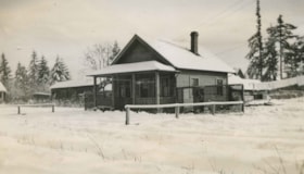
Martin family home in winter
https://search.heritageburnaby.ca/link/archivedescription36430
- Repository
- City of Burnaby Archives
- Date
- 1932
- Collection/Fonds
- Burnaby Historical Society fonds
- Description Level
- Item
- Physical Description
- 1 photograph : sepia ; 6 x 10.5 cm
- Scope and Content
- Photograph of the Martin family home in the winter, covered in snow. The house was at 2671 McKay Avenue (renumbered 6408 McKay Avenue - this area has since been further sub-divided).
- Repository
- City of Burnaby Archives
- Date
- 1932
- Collection/Fonds
- Burnaby Historical Society fonds
- Subseries
- Martin family subseries
- Physical Description
- 1 photograph : sepia ; 6 x 10.5 cm
- Description Level
- Item
- Record No.
- 270-002
- Access Restriction
- No restrictions
- Reproduction Restriction
- No known restrictions
- Accession Number
- BHS1991-39
- Scope and Content
- Photograph of the Martin family home in the winter, covered in snow. The house was at 2671 McKay Avenue (renumbered 6408 McKay Avenue - this area has since been further sub-divided).
- Media Type
- Photograph
- Notes
- Title based on contents of photograph
- Geographic Access
- McKay Avenue
- Historic Neighbourhood
- Central Park (Historic Neighbourhood)
- Planning Study Area
- Maywood Area
Images

![Mary England's home, [1934] (date of original) , copied 2020 thumbnail](/media/hpo/_Data/_BVM_Images/2020/2020_0009_0004_001.jpg?width=280)
Mary England's home
https://search.heritageburnaby.ca/link/museumdescription12232
- Repository
- Burnaby Village Museum
- Date
- [1934] (date of original) , copied 2020
- Collection/Fonds
- Mary England fonds
- Description Level
- Item
- Physical Description
- 1 photograph (tiff) : b&w ; 600 dpi
- Scope and Content
- Photograph of Mary England (nee Gooding) standing outside on the lawn of her home located at 2125 Griffiths Street in Burnaby. The house was built by Mary England in 1930 in a revival style and has been recognized on the Burnaby Community Heritage Register.
- Repository
- Burnaby Village Museum
- Collection/Fonds
- Mary England fonds
- Description Level
- Item
- Physical Description
- 1 photograph (tiff) : b&w ; 600 dpi
- Scope and Content
- Photograph of Mary England (nee Gooding) standing outside on the lawn of her home located at 2125 Griffiths Street in Burnaby. The house was built by Mary England in 1930 in a revival style and has been recognized on the Burnaby Community Heritage Register.
- Names
- England, Mary
- Geographic Access
- Griffiths Avenue
- Street Address
- 7276 Griffiths Drive
- Accession Code
- BV020.9.4
- Access Restriction
- No restrictions
- Reproduction Restriction
- May be restricted by third party rights
- Date
- [1934] (date of original) , copied 2020
- Media Type
- Photograph
- Historic Neighbourhood
- Edmonds (Historic Neighbourhood)
- Planning Study Area
- Stride Avenue Area
- Scan Resolution
- 600
- Scan Date
- 12-Feb-20
- Scale
- 100
- Notes
- Title based on contents of photograph
Images
![Mary England's home, [1934] (date of original) , copied 2020 thumbnail](/media/hpo/_Data/_BVM_Images/2020/2020_0009_0004_001.jpg)
![Mathers house, [between 1925 and 1935] (date of original), copied 1985 thumbnail](/media/hpo/_Data/_BVM_Images/1985/1985_0057_0003_001.jpg?width=280)
Mathers house
https://search.heritageburnaby.ca/link/museumdescription168
- Repository
- Burnaby Village Museum
- Date
- [between 1925 and 1935] (date of original), copied 1985
- Collection/Fonds
- Burnaby Village Museum Photograph collection
- Description Level
- Item
- Physical Description
- 1 photograph : b&w ; 20.2 x 25.2 cm print
- Scope and Content
- Photograph of the Mathers house in 1935. The house is now part of the Deer Lake Park Complex and is used for various artistic and cultural activities. According to a note prepared by Kathleen and Eileen Mathers, the house otherwise known as "Altnadene" was built in 1911-1912 for Mr. and Mrs. W.J. …
- Repository
- Burnaby Village Museum
- Collection/Fonds
- Burnaby Village Museum Photograph collection
- Description Level
- Item
- Physical Description
- 1 photograph : b&w ; 20.2 x 25.2 cm print
- Scope and Content
- Photograph of the Mathers house in 1935. The house is now part of the Deer Lake Park Complex and is used for various artistic and cultural activities. According to a note prepared by Kathleen and Eileen Mathers, the house otherwise known as "Altnadene" was built in 1911-1912 for Mr. and Mrs. W.J. Mathers of New Westminster by architect F.W. Macey who lived on Douglas Road. The house was occupied by the family from late-1912 until mid-1935. The original photographs have been taken by professional photographers. The accession register dates the photograph ca. 1935 while the inscription dates it late-1920's. An annotation on the back of the photograph reads: "late '20s."
- Subjects
- Buildings - Residential - Houses
- Geographic Access
- Deer Lake Avenue
- Street Address
- 6490 Deer Lake Avenue
- Accession Code
- BV985.57.3
- Access Restriction
- No restrictions
- Reproduction Restriction
- No known restrictions
- Date
- [between 1925 and 1935] (date of original), copied 1985
- Media Type
- Photograph
- Historic Neighbourhood
- Burnaby Lake (Historic Neighbourhood)
- Planning Study Area
- Douglas-Gilpin Area
- Scan Resolution
- 600
- Scan Date
- 2023-12-19
- Notes
- Title based on contents of photograph
Images
![Mathers house, [between 1925 and 1935] (date of original), copied 1985 thumbnail](/media/hpo/_Data/_BVM_Images/1985/1985_0057_0003_001.jpg)
![Mayhew family home, [193-?] (date of original), copied 1992 thumbnail](/media/hpo/_Data/_Archives_Images/_Unrestricted/315/315-542.jpg?width=280)
Mayhew family home
https://search.heritageburnaby.ca/link/archivedescription37079
- Repository
- City of Burnaby Archives
- Date
- [193-?] (date of original), copied 1992
- Collection/Fonds
- Burnaby Historical Society fonds
- Description Level
- Item
- Physical Description
- 1 photograph : b&w ; 8.8 x 12.7 cm print
- Scope and Content
- Photograph of the Mayhew family home at the corner of Edna Street (now Grange Street) and Sussex Avenue. Ann and Edward Mayhew lived here with their two daughters: Edna Jean and Margrett Ellen.
- Repository
- City of Burnaby Archives
- Date
- [193-?] (date of original), copied 1992
- Collection/Fonds
- Burnaby Historical Society fonds
- Subseries
- Burnaby Centennial Anthology subseries
- Physical Description
- 1 photograph : b&w ; 8.8 x 12.7 cm print
- Description Level
- Item
- Record No.
- 315-542
- Access Restriction
- No restrictions
- Reproduction Restriction
- No known restrictions
- Accession Number
- BHS1994-04
- Scope and Content
- Photograph of the Mayhew family home at the corner of Edna Street (now Grange Street) and Sussex Avenue. Ann and Edward Mayhew lived here with their two daughters: Edna Jean and Margrett Ellen.
- Subjects
- Buildings - Residential - Houses
- Media Type
- Photograph
- Notes
- Title based on contents of photograph
- Geographic Access
- Hall Avenue
- Sussex Avenue
- Grange Street
- Historic Neighbourhood
- Central Park (Historic Neighbourhood)
- Planning Study Area
- Marlborough Area
Images
![Mayhew family home, [193-?] (date of original), copied 1992 thumbnail](/media/hpo/_Data/_Archives_Images/_Unrestricted/315/315-542.jpg)