More like 'Alfred Bingham's writings - Track 2'
Narrow Results By
Decade
- 2020s 96
- 2010s 48
- 2000s 486
- 1990s
- 1980s 423
- 1970s 955
- 1960s 287
- 1950s 466
- 1940s 465
- 1930s 356
- 1920s
- 1910s 477
- 1900s 190
- 1890s 30
- 1880s
- 1870s 4
- 1860s 2
- 1850s 1
- 1840s 1
- 1830s 1
- 1820s 1
- 1810s 1
- 1800s 1
- 1790s 1
- 1780s 1
- 1770s 1
- 1760s 1
- 1750s 1
- 1740s 1
- 1730s 1
- 1720s 1
- 1710s 1
- 1700s 1
- 1690s 1
- 1680s 1
- 1670s 1
- 1660s 1
- 1650s 1
- 1640s 1
- 1630s 1
- 1620s 1
- 1610s 1
- 1600s 1
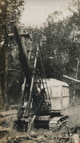
Parked for the weekend
https://search.heritageburnaby.ca/link/archivedescription34386
- Repository
- City of Burnaby Archives
- Date
- 1926
- Collection/Fonds
- Burnaby Historical Society fonds
- Description Level
- Item
- Physical Description
- 1 photograph : b&w ; 6.3 x 11.5 cm on page 17.5 x 26.3 cm
- Scope and Content
- Photograph of a steam shovel sitting in a small clearing in the woods. The location is unknown. This photograph appears to have been taken by Arthur Peers, who travelled through the Fraser River Valley and worked on the construction of the Trans-Provincial Highway during the later 1920s.
- Repository
- City of Burnaby Archives
- Date
- 1926
- Collection/Fonds
- Burnaby Historical Society fonds
- Subseries
- Peers family subseries
- Physical Description
- 1 photograph : b&w ; 6.3 x 11.5 cm on page 17.5 x 26.3 cm
- Description Level
- Item
- Record No.
- 020-093
- Access Restriction
- No restrictions
- Reproduction Restriction
- No known restrictions
- Accession Number
- BHS2007-04
- Scope and Content
- Photograph of a steam shovel sitting in a small clearing in the woods. The location is unknown. This photograph appears to have been taken by Arthur Peers, who travelled through the Fraser River Valley and worked on the construction of the Trans-Provincial Highway during the later 1920s.
- Subjects
- Land Clearing
- Media Type
- Photograph
- Photographer
- Peers, Arthur Francis "Mike"
- Notes
- Title based on caption accompanying photograph
Images

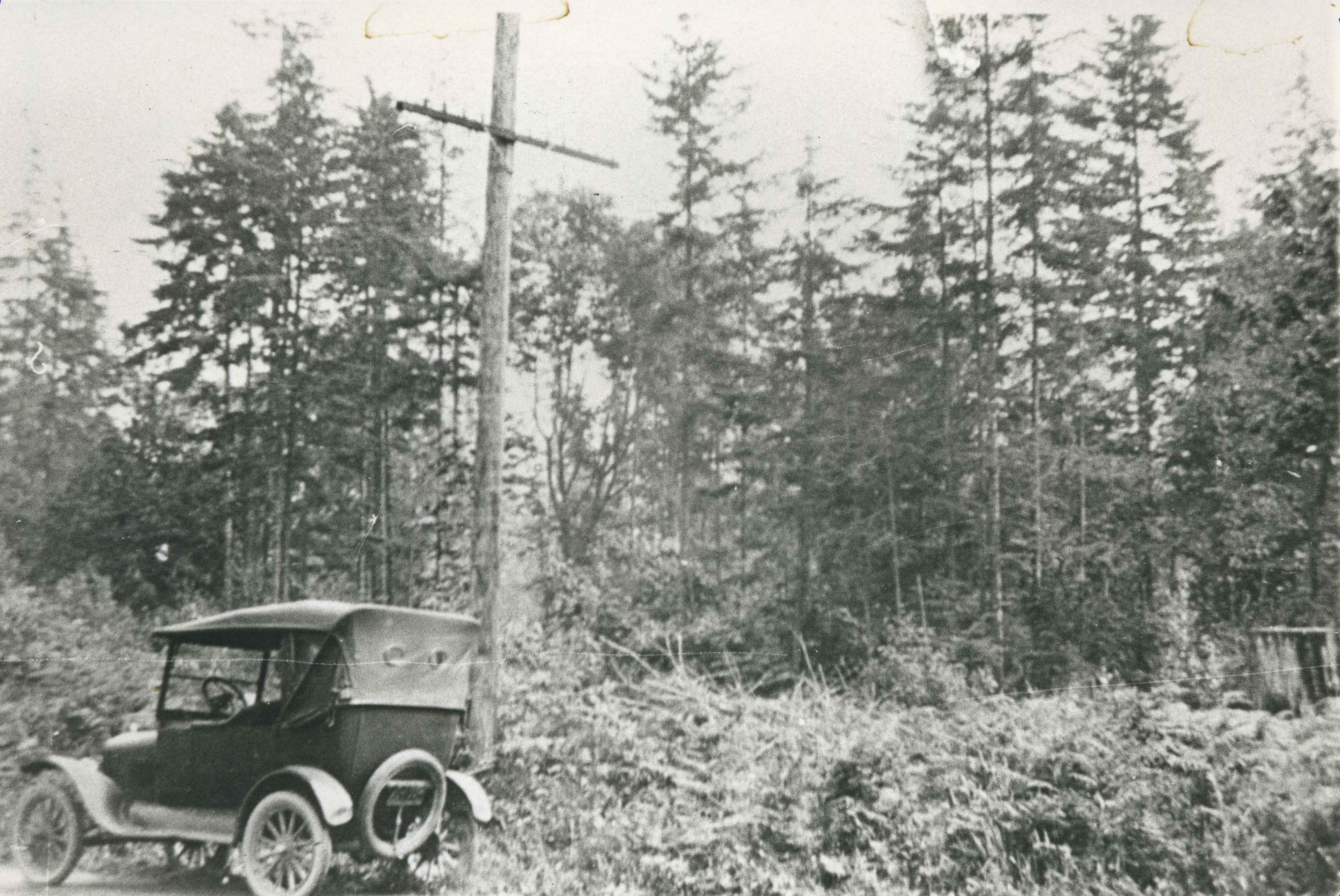
Parliament Family Lot
https://search.heritageburnaby.ca/link/archivedescription35528
- Repository
- City of Burnaby Archives
- Date
- 1923 (date of original), copied 1986
- Collection/Fonds
- Burnaby Historical Society fonds
- Description Level
- Item
- Physical Description
- 1 photograph : b&w ; 12.7 x 17.8 cm print
- Scope and Content
- Photograph of the lot on the 5770 block of Hastings Street for the Parliament family home before it was cleared. The home became known as the "Half-house" because it was only half completed when money ran out, so it was left half finished. Note the car in front.
- Repository
- City of Burnaby Archives
- Date
- 1923 (date of original), copied 1986
- Collection/Fonds
- Burnaby Historical Society fonds
- Subseries
- Pioneer Tales subseries
- Physical Description
- 1 photograph : b&w ; 12.7 x 17.8 cm print
- Description Level
- Item
- Record No.
- 204-386
- Access Restriction
- No restrictions
- Reproduction Restriction
- No known restrictions
- Accession Number
- BHS1988-03
- Scope and Content
- Photograph of the lot on the 5770 block of Hastings Street for the Parliament family home before it was cleared. The home became known as the "Half-house" because it was only half completed when money ran out, so it was left half finished. Note the car in front.
- Subjects
- Land Clearing
- Media Type
- Photograph
- Notes
- Title based on contents of photograph
- Geographic Access
- Hastings Street
- Historic Neighbourhood
- Capitol Hill (Historic Neighbourhood)
- Planning Study Area
- Parkcrest-Aubrey Area
Images

Residents involved in protesting tree removal
https://search.heritageburnaby.ca/link/archivedescription78595
- Repository
- City of Burnaby Archives
- Date
- October 8, 1995
- Collection/Fonds
- Burnaby NewsLeader photograph collection
- Description Level
- Item
- Physical Description
- 1 photograph : b&w ; 16.5 x 24.5 cm
- Scope and Content
- Photograph of residents of Burnaby protesting the clearing of land around the Hong Kong Bank, in Discovery Park industrial site near British Columbia Institute of Technology (BCIT).
- Repository
- City of Burnaby Archives
- Date
- October 8, 1995
- Collection/Fonds
- Burnaby NewsLeader photograph collection
- Physical Description
- 1 photograph : b&w ; 16.5 x 24.5 cm
- Description Level
- Item
- Record No.
- 535-0011
- Access Restriction
- No restrictions
- Reproduction Restriction
- No reproduction permitted
- Accession Number
- 2012-11
- Scope and Content
- Photograph of residents of Burnaby protesting the clearing of land around the Hong Kong Bank, in Discovery Park industrial site near British Columbia Institute of Technology (BCIT).
- Names
- Chami, Parvin
- Media Type
- Photograph
- Photographer
- Ponne, Simone
- Notes
- Title based on contents of photograph
- Note in black ink on recto of photograph reads: "2764A Bby Ponne / Bby p. 1 81%"
- Trim marks and/or reproduction instructions on recto (scan is cropped)
- Geographic Access
- Willingdon Avenue
- Planning Study Area
- Douglas-Gilpin Area
Images


Road cleared through a forest
https://search.heritageburnaby.ca/link/archivedescription34400
- Repository
- City of Burnaby Archives
- Date
- 1926
- Collection/Fonds
- Burnaby Historical Society fonds
- Description Level
- Item
- Physical Description
- 1 photograph : b&w ; 6.5 x 10 cm on page 17.5 x 26.5 cm
- Scope and Content
- Photograph of a roadway that has been cut through the forest. Tree stumps are lining the road and the ground is covered with snow. A caption adjacent to the photograph reads "Tony's Work." This photograph appears to have been taken by Arthur Peers, who travelled through the Fraser River Valley and…
- Repository
- City of Burnaby Archives
- Date
- 1926
- Collection/Fonds
- Burnaby Historical Society fonds
- Subseries
- Peers family subseries
- Physical Description
- 1 photograph : b&w ; 6.5 x 10 cm on page 17.5 x 26.5 cm
- Description Level
- Item
- Record No.
- 020-107
- Access Restriction
- No restrictions
- Reproduction Restriction
- No known restrictions
- Accession Number
- BHS2007-04
- Scope and Content
- Photograph of a roadway that has been cut through the forest. Tree stumps are lining the road and the ground is covered with snow. A caption adjacent to the photograph reads "Tony's Work." This photograph appears to have been taken by Arthur Peers, who travelled through the Fraser River Valley and worked on the construction of the Trans-Provincial Highway during the later 1920s.
- Media Type
- Photograph
- Photographer
- Peers, Arthur Francis "Mike"
- Notes
- Title based on contents of photograph
Images

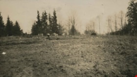
The Tennis Courts Under Construction
https://search.heritageburnaby.ca/link/archivedescription39219
- Repository
- City of Burnaby Archives
- Date
- 1923
- Collection/Fonds
- Peers Family and Hill Family fonds
- Description Level
- Item
- Physical Description
- 1 photograph : b&w ; 6 x 10.8 cm on page 24.5 x 32.5 cm (pasted in album)
- Scope and Content
- Photograph shows the land clearing undertaken in preparation for the construction of tennis courts at the home of Bob and Kitty Peers family on Deer Lake Avenue.
- Repository
- City of Burnaby Archives
- Date
- 1923
- Collection/Fonds
- Peers Family and Hill Family fonds
- Physical Description
- 1 photograph : b&w ; 6 x 10.8 cm on page 24.5 x 32.5 cm (pasted in album)
- Description Level
- Item
- Record No.
- 477-538
- Access Restriction
- No restrictions
- Reproduction Restriction
- No known restrictions
- Accession Number
- 2007-12
- Scope and Content
- Photograph shows the land clearing undertaken in preparation for the construction of tennis courts at the home of Bob and Kitty Peers family on Deer Lake Avenue.
- Subjects
- Land Clearing
- Media Type
- Photograph
- Notes
- Title based on caption accompanying photograph
- Geographic Access
- Deer Lake Avenue
- Street Address
- 6588 Deer Lake Avenue
- Historic Neighbourhood
- Burnaby Lake (Historic Neighbourhood)
- Planning Study Area
- Douglas-Gilpin Area
Images

![Volunteers clearing site for Lozells Hall, [1920] (date of original), copied 1992 thumbnail](/media/hpo/_Data/_Archives_Images/_Unrestricted/315/315-521.jpg?width=280)
Volunteers clearing site for Lozells Hall
https://search.heritageburnaby.ca/link/archivedescription37058
- Repository
- City of Burnaby Archives
- Date
- [1920] (date of original), copied 1992
- Collection/Fonds
- Burnaby Historical Society fonds
- Description Level
- Item
- Physical Description
- 1 photograph : b&w ; 12.7 x 17.7 cm print
- Scope and Content
- Photograph of volunteers clearing the site for the original Lozells Community Hall.
- Repository
- City of Burnaby Archives
- Date
- [1920] (date of original), copied 1992
- Collection/Fonds
- Burnaby Historical Society fonds
- Subseries
- Burnaby Centennial Anthology subseries
- Physical Description
- 1 photograph : b&w ; 12.7 x 17.7 cm print
- Description Level
- Item
- Record No.
- 315-521
- Access Restriction
- No restrictions
- Reproduction Restriction
- No known restrictions
- Accession Number
- BHS1994-04
- Scope and Content
- Photograph of volunteers clearing the site for the original Lozells Community Hall.
- Subjects
- Transportation - Horses
- Land Clearing
- Names
- Lozells Community Hall
- Media Type
- Photograph
- Notes
- Title based on contents of photograph
- Geographic Access
- Government Road
- Lozells Avenue
- Historic Neighbourhood
- Lozells (Historic Neighbourhood)
- Planning Study Area
- Government Road Area
Images
![Volunteers clearing site for Lozells Hall, [1920] (date of original), copied 1992 thumbnail](/media/hpo/_Data/_Archives_Images/_Unrestricted/315/315-521.jpg)

Interview with Sev Morin by Rod Fowler April 4, 1990 - Track 2
https://search.heritageburnaby.ca/link/oralhistory538
- Repository
- City of Burnaby Archives
- Date Range
- 1950-1990
- Length
- 00:06:16
- Summary
- This portion of the interview is about Sev Morin’s description of Burnaby’s growth and business development along Kingsway and Hastings, the Lake City Industrial Park, and the purchase of property in 1958 for the Heritage Park and Art Gallery.
- Repository
- City of Burnaby Archives
- Summary
- This portion of the interview is about Sev Morin’s description of Burnaby’s growth and business development along Kingsway and Hastings, the Lake City Industrial Park, and the purchase of property in 1958 for the Heritage Park and Art Gallery.
- Date Range
- 1950-1990
- Photo Info
- Sev Morin (left) of Severin's in Burnaby (formerly the Gai Paree) hosting a gala New Year's celebration, 1979. Item no. 480-712
- Length
- 00:06:16
- Subjects
- Buildings - Commercial
- Buildings - Civic
- Buildings - Industrial
- Buildings - Schools - Universities and Colleges
- Historic Neighbourhood
- Central Park (Historic Neighbourhood)
- Burnaby Lake (Historic Neighbourhood)
- Vancouver Heights (Historic Neighbourhood)
- Edmonds (Historic Neighbourhood)
- Planning Study Area
- Burnaby Heights Area
- Lake City Area
- Burnaby Mountain Area
- Kingsway-Beresford Area
- Douglas-Gilpin Area
- Interviewer
- Fowler, Rod
- Interview Date
- April 4, 1990
- Scope and Content
- Recording is of an interview with Severin "Sev" Morin, conducted by Rod Fowler. Sev Morin was one of eleven participants interviewed as part of the SFU/Burnaby Centennial Committee's oral history series titled, "Voices of Burnaby". The interview is mainly about Sev Morin’s banquet hall, restaurant and night club business on Kingsway, originally named the “Gai Paree Supper Club” (1947-1976) and later “Severin’s” (1976-1985) and “Diego’s” (1985-1994), its function as a Burnaby landmark, and the entertainment and political people he met through his business. He also describes his many volunteer activities in Burnaby, including member of the SFU Senate, Rotary Club, Variety Club and Telethon, fund raising for Burnaby Hospital, and tourism related groups, and his political work for the federal Liberal party. He talks about his parents’ origins, the lives of his brothers Rudy and Rene, and the family’s involvement in establishing the “Gai Paree”. He also shares his views about the business and cultural development of Burnaby. To view “Narrow By” terms for each track expand this description and see “Notes”.
- Biographical Notes
- Severin “Sev” Rene Morin was born September 21, 1927, in Bonneville, Alberta, to Rene Pierre Morin (1878-1963) and Anne Marie (nee Lachiver) Morin (1886-1956). Mr. and Mrs. R. P. Morin and their son Rene Francois (1905-1954) immigrated to Edmonton, Alberta, from France in 1913, where Rene Pierre Morin worked for the C.N.R. and a second son Adolphe “Rudy” Ferdinand (1922-1969) was born, followed by their third son Severin. In 1943, after R.P. Morin retired, the family moved to Burnaby to a house on Sperling Avenue. Sometime earlier the two older Morin brothers found work in Trail at the smelter and developed musical careers. In 1946/47 the Morin family purchased property on Kingsway and built a banquet hall, the “Gai Paree Supper Club”. Sev and Rudy Morin managed the club and Rene F. Morin moved to Burnaby to join them with his band. The supper club, with its live music and dance floor, became a popular meeting place and wedding venue, eventually expanding into a restaurant and nightclub in the 1970s. The “Gai Paree” was renamed “Severin’s” in 1976 and “Diego’s” in 1985, closing finally in 1994. Sev Morin’s business life included three record stores which he owned with his friend Jack Cullen. Through these businesses Sev Morin was well known in the entertainment and hospitality industry. He and his restaurant also hosted political and social events that made the restaurant a community landmark. Sev Morin contributed many volunteer hours to community and charitable organizations, including an appointment to the SFU Senate, fundraising for the Burnaby Hospital, Director of the Variety Club and Rotary Club, and consultant for a variety of tourism related ventures. He also was active in the federal Liberal Party. Sev Morin and his wife Pauline married in 1950 and had three children. Sev Morin died at age 86 on March 28, 2014.
- Total Tracks
- 10
- Total Length
- 00:56:44
- Interviewee Name
- Morin, Severin "Sev"
- Interviewer Bio
- Rod Fowler returned to university as a mature student in the 1980s after working about twenty years in the field of economics and computerization in business in England, Europe and Western Canada. He graduated with a BA from SFU in both History and Sociology in 1987, his MA degree in Geography in 1989, and his PhD in Cultural Geography at SFU. He taught courses in Geography, Sociology, History and Canadian Studies at several Lower Mainland colleges, before becoming a full time member of the Geography Department at Kwantlen University College.
- Collection/Fonds
- SFU/Burnaby Centennial Committee fonds
- Transcript Available
- Transcript available
- Media Type
- Sound Recording
- Web Notes
- Interviews were digitized in 2015 allowing them to be accessible on Heritage Burnaby. The digitization project was initiated by the Community Heritage Commission with support from City of Burnaby Council.
Images

Audio Tracks
Track two of interview with Sev Morin
Track two of interview with Sev Morin
https://search.heritageburnaby.ca/media/hpo/_Data/_Archives_Oral_Histories/_Unrestricted/MSS187-021/MSS187-021_Track%202.mp33735-3765 and 3815-3835 First Ave
https://search.heritageburnaby.ca/link/archivedescription93753
- Repository
- City of Burnaby Archives
- Date
- March 25, 1992
- Collection/Fonds
- Grover, Elliott & Co. Ltd. fonds
- Description Level
- File
- Physical Description
- 47 photographs : col. negatives ; 35 mm
- Scope and Content
- Photographs of the commercial-industrial buildings and loading bays located at 3735-3765 and 3815-3835 1st Avenue.
- Repository
- City of Burnaby Archives
- Date
- March 25, 1992
- Collection/Fonds
- Grover, Elliott & Co. Ltd. fonds
- Physical Description
- 47 photographs : col. negatives ; 35 mm
- Description Level
- File
- Record No.
- 622-038
- Access Restriction
- No restrictions
- Reproduction Restriction
- No restrictions
- Accession Number
- 2017-39
- Scope and Content
- Photographs of the commercial-industrial buildings and loading bays located at 3735-3765 and 3815-3835 1st Avenue.
- Subjects
- Buildings - Commercial
- Buildings - Industrial
- Transportation - Trucks
- Transportation - Automobiles
- Media Type
- Photograph
- Photographer
- Young, Richard
- Notes
- Transcribed title
- Title transcribed from envelope photographs were originally housed in
- File no. 92-139-B
- Geographic Access
- 1st Avenue
- Street Address
- 3735 1st Avenue
- 3815 1st Avenue
- Historic Neighbourhood
- Broadview (Historic Neighbourhood)
- Planning Study Area
- West Central Valley Area
5820 S.E. Marine Dr. Burnaby
https://search.heritageburnaby.ca/link/archivedescription94301
- Repository
- City of Burnaby Archives
- Date
- February 1994
- Collection/Fonds
- Grover, Elliott & Co. Ltd. fonds
- Description Level
- File
- Physical Description
- 19 photographs : col. negatives ; 35 mm
- Scope and Content
- Photographs of the commercial property located at 5820 Marine Drive and along the 5800 block of Marine Drive.
- Repository
- City of Burnaby Archives
- Date
- February 1994
- Collection/Fonds
- Grover, Elliott & Co. Ltd. fonds
- Physical Description
- 19 photographs : col. negatives ; 35 mm
- Description Level
- File
- Record No.
- 622-086
- Access Restriction
- No restrictions
- Reproduction Restriction
- No restrictions
- Accession Number
- 2017-39
- Scope and Content
- Photographs of the commercial property located at 5820 Marine Drive and along the 5800 block of Marine Drive.
- Media Type
- Photograph
- Notes
- Transcribed title
- Title transcribed from envelope photographs were originally housed in
- File no. 94-015-B
- Photographer identified as "K.H."
- Geographic Access
- Marine Drive
- Street Address
- 5820 Marine Drive
- Historic Neighbourhood
- Fraser Arm (Historic Neighbourhood)
- Planning Study Area
- Big Bend Area
8503-8537 Eastlake dr / 2820-2880 Production Way / & 8500-8544 Baxter Place
https://search.heritageburnaby.ca/link/archivedescription93889
- Repository
- City of Burnaby Archives
- Date
- October - November 1993
- Collection/Fonds
- Grover, Elliott & Co. Ltd. fonds
- Description Level
- File
- Physical Description
- 19 photographs : col. negatives ; 35 mm
- Scope and Content
- Photographs of the exteriors of the commercial-industrial buildings located at 8503-8537 Eastlake Drive, 2820-2880 Production Way, and 8500-8544 Baxter Place.
- Repository
- City of Burnaby Archives
- Date
- October - November 1993
- Collection/Fonds
- Grover, Elliott & Co. Ltd. fonds
- Physical Description
- 19 photographs : col. negatives ; 35 mm
- Description Level
- File
- Record No.
- 622-072
- Access Restriction
- No restrictions
- Reproduction Restriction
- No restrictions
- Accession Number
- 2017-39
- Scope and Content
- Photographs of the exteriors of the commercial-industrial buildings located at 8503-8537 Eastlake Drive, 2820-2880 Production Way, and 8500-8544 Baxter Place.
- Media Type
- Photograph
- Notes
- Transcribed title
- Title transcribed from envelope photographs were originally housed in
- File no. 93-178-B
- Photographer identified as "M.G."
- Geographic Access
- Eastlake Drive
- Production Way
- Baxter Place
- Street Address
- 2800 Production Way
- Planning Study Area
- Lake City Area
3183 Norland Rd
https://search.heritageburnaby.ca/link/archivedescription94298
- Repository
- City of Burnaby Archives
- Date
- November 1993
- Collection/Fonds
- Grover, Elliott & Co. Ltd. fonds
- Description Level
- File
- Physical Description
- 44 photographs : col. negatives ; 35 mm
- Scope and Content
- Photographs of the exterior of the two-storey industrial property located at 3183 Norland Avenue. Industrial Movers Ltd. and Pacific are the tenants of the property.
- Repository
- City of Burnaby Archives
- Date
- November 1993
- Collection/Fonds
- Grover, Elliott & Co. Ltd. fonds
- Physical Description
- 44 photographs : col. negatives ; 35 mm
- Description Level
- File
- Record No.
- 622-083
- Access Restriction
- No restrictions
- Reproduction Restriction
- No restrictions
- Accession Number
- 2017-39
- Scope and Content
- Photographs of the exterior of the two-storey industrial property located at 3183 Norland Avenue. Industrial Movers Ltd. and Pacific are the tenants of the property.
- Subjects
- Buildings - Industrial
- Media Type
- Photograph
- Notes
- Transcribed title
- Title transcribed from envelope photographs were originally housed in
- File no. 93-474-B
- Photographer identified as "D.E."
- Geographic Access
- Norland Avenue
- Street Address
- 3183 Norland Avenue
- Historic Neighbourhood
- Burnaby Lake (Historic Neighbourhood)
- Planning Study Area
- Ardingley-Sprott Area
4200 Phillips Ave
https://search.heritageburnaby.ca/link/archivedescription94317
- Repository
- City of Burnaby Archives
- Date
- September 1994
- Collection/Fonds
- Grover, Elliott & Co. Ltd. fonds
- Description Level
- File
- Physical Description
- 24 photographs : col. negatives ; 35 mm
- Scope and Content
- Photographs of the exterior of a single-storey industrial building located at 4200 Phillips Avenue - an address that no longer exists.
- Repository
- City of Burnaby Archives
- Date
- September 1994
- Collection/Fonds
- Grover, Elliott & Co. Ltd. fonds
- Physical Description
- 24 photographs : col. negatives ; 35 mm
- Description Level
- File
- Record No.
- 622-102
- Access Restriction
- No restrictions
- Reproduction Restriction
- No restrictions
- Accession Number
- 2017-39
- Scope and Content
- Photographs of the exterior of a single-storey industrial building located at 4200 Phillips Avenue - an address that no longer exists.
- Subjects
- Buildings - Industrial
- Media Type
- Photograph
- Notes
- Transcribed title
- Title transcribed from envelope photographs were originally housed in
- File no. 94-329-B
- Photographer identified as "J.C."
- Geographic Access
- Phillips Avenue
- Historic Neighbourhood
- Lozells (Historic Neighbourhood)
- Planning Study Area
- Government Road Area
5324 Thorne Ave
https://search.heritageburnaby.ca/link/archivedescription93762
- Repository
- City of Burnaby Archives
- Date
- June 12, 1992
- Collection/Fonds
- Grover, Elliott & Co. Ltd. fonds
- Description Level
- File
- Physical Description
- 120 photographs : col. negatives ; 35 mm
- Scope and Content
- Photographs of an industrial property located at 5324 Thorne Avenue - an address than no longer exists.
- Repository
- City of Burnaby Archives
- Date
- June 12, 1992
- Collection/Fonds
- Grover, Elliott & Co. Ltd. fonds
- Physical Description
- 120 photographs : col. negatives ; 35 mm
- Description Level
- File
- Record No.
- 622-047
- Access Restriction
- No restrictions
- Reproduction Restriction
- No restrictions
- Accession Number
- 2017-39
- Scope and Content
- Photographs of an industrial property located at 5324 Thorne Avenue - an address than no longer exists.
- Subjects
- Buildings - Industrial
- Media Type
- Photograph
- Notes
- Transcribed title
- Title transcribed from envelope photographs were originally housed in
- File no. 92-224-I
- Note adhered to 622-047-001 print reads: "11 / The manufacturing plant [illegible], southwest from the northweast corner of the site".
- Note adhered to 622-047-5 print reads: "17 / view south along the east side of the property from Thorne Avenue".
- Note adhered to 622-047-9 print reads: "18 / The canopy at loading area and shed addition of the [illegible] and of the building".
- Note adhered to 622-047-13 print reads: "19 / View of the interior of the building looking towards to west".
- Note adhered to 622-047-17 print reads: "23 / view east across the site immediately south of the building".
- Note adhered to 622-047-21 print reads: "22 / view looking north west twoards the south facade".
- Note adhered to 622-047-25 print reads: "8 / The freestanding office building adjacent to Thorne Avenue and Wiggins Street".
- Note adhered to 622-047-29 print reads: "9 / View of its front entr [sid] and the office building".
- Note adhered to 622-047-33 reads: "10 / View west towards the office building from the main vehicle entr [sic] at Thorne Avenue".
- Note adhered to 622-047-37 print reads: "14 / View east across the north yard area".
- Note adhered to 622-047-41 print reads: "12 / View of the north facade looking south."
- Note adhered to 622-047-45 print reads: "13 / View west across the north yard area".
- Note adhered to 622-047-49 print reads: "20 / The [illegible] building".
- Note adhered to 622-047-53 print reads: "26 / View northeast from the west property line".
- Note adhered to 622-047-57 print reads: "21 / View looking northeast at the south facade".
- Note adhered to 622-047-61 print reads: "16 / View north along the west side of the manufacturing building".
- Note adhered to 622-047-65 print reads: "15 / View of the north west corner of the manufacturing building".
- Note adhered to 622-047-69 print reads: "3 / View west along Thorne Avenue from the east side of the property".
- Note adhered to 622-047-73 print reads: "25 / View north from the southeast corner of the property".
- Note adhered to 622-047-77 print reads: "30 / View of the dock looking southeast from the property".
- Note adhered to 622-047-81 print reads: "24 / View north from the southwest corner of the property".
- Note adhered to 622-047-85 print reads: "27 / The barge dock at the southwest corner of the site".
- Note adhered to 622-047-89 print reads: "29 / View east along the river front".
- Note adhered to 622-047-93 print reads: "28 / View of the dolphins and mooring area".
- Note adhered to 622-047-97 print reads: "4 / View west along [illegible] Avenue past the entrance to the north parking lot".
- Note adhered to 622-047-101 print reads: "2 / View southwest from Thorne Avenue".
- Note adhered to 622-047-105 print reads: "5 / View west across the north parking lot".
- Note adhered to 622-047-113 print reads: "6 / View southeast from the north parking lot".
- Photographer identified as "D.E."
- Geographic Access
- Thorne Avenue
- Historic Neighbourhood
- Fraser Arm (Historic Neighbourhood)
- Planning Study Area
- Big Bend Area
6501 Sprott St
https://search.heritageburnaby.ca/link/archivedescription93771
- Repository
- City of Burnaby Archives
- Date
- September 1992
- Collection/Fonds
- Grover, Elliott & Co. Ltd. fonds
- Description Level
- File
- Physical Description
- 48 photographs : col. negatives ; 35 mm
- Scope and Content
- Photographs of the industrial property located at 6501 Sprott Street, which includestwo buildings and a parking lot.
- Repository
- City of Burnaby Archives
- Date
- September 1992
- Collection/Fonds
- Grover, Elliott & Co. Ltd. fonds
- Physical Description
- 48 photographs : col. negatives ; 35 mm
- Description Level
- File
- Record No.
- 622-055
- Access Restriction
- No restrictions
- Reproduction Restriction
- No restrictions
- Accession Number
- 2017-39
- Scope and Content
- Photographs of the industrial property located at 6501 Sprott Street, which includestwo buildings and a parking lot.
- Subjects
- Buildings - Industrial
- Media Type
- Photograph
- Notes
- Transcribed title
- Title transcribed from envelope photographs were originally housed in
- File no. 92-327-B
- Photographer identified as "D.C."
- Geographic Access
- Sprott Street
- Street Address
- 6501 Sprott Street
- Historic Neighbourhood
- Burnaby Lake (Historic Neighbourhood)
- Planning Study Area
- Ardingley-Sprott Area
6741 Cariboo Rd Burnaby
https://search.heritageburnaby.ca/link/archivedescription94308
- Repository
- City of Burnaby Archives
- Date
- April 1994
- Collection/Fonds
- Grover, Elliott & Co. Ltd. fonds
- Description Level
- File
- Physical Description
- 25 photographs : col. negatives ; 35 mm
- Scope and Content
- Photographs of an undeveloped property, single-storey industrial building, and railroad crossing.
- Repository
- City of Burnaby Archives
- Date
- April 1994
- Collection/Fonds
- Grover, Elliott & Co. Ltd. fonds
- Physical Description
- 25 photographs : col. negatives ; 35 mm
- Description Level
- File
- Record No.
- 622-093
- Access Restriction
- No restrictions
- Reproduction Restriction
- No restrictions
- Accession Number
- 2017-39
- Scope and Content
- Photographs of an undeveloped property, single-storey industrial building, and railroad crossing.
- Media Type
- Photograph
- Photographer
- Young, Richard
- Notes
- Transcribed title
- Title transcribed from envelope photographs were originally housed in
- File no. 94-115-B
- Geographic Access
- Cariboo Road
- Street Address
- 6741 Cariboo Road
- Planning Study Area
- Burnaby Lake Area
7050 Buller Ave
https://search.heritageburnaby.ca/link/archivedescription93884
- Repository
- City of Burnaby Archives
- Date
- March 1993
- Collection/Fonds
- Grover, Elliott & Co. Ltd. fonds
- Description Level
- File
- Physical Description
- 25 photographs : col. negatives ; 35 mm
- Scope and Content
- Photographs of an industrial building located at 7050 Buller Avenue taken from Buller Avenue and Beresford Street.
- Repository
- City of Burnaby Archives
- Date
- March 1993
- Collection/Fonds
- Grover, Elliott & Co. Ltd. fonds
- Physical Description
- 25 photographs : col. negatives ; 35 mm
- Description Level
- File
- Record No.
- 622-067
- Access Restriction
- No restrictions
- Reproduction Restriction
- No restrictions
- Accession Number
- 2017-39
- Scope and Content
- Photographs of an industrial building located at 7050 Buller Avenue taken from Buller Avenue and Beresford Street.
- Media Type
- Photograph
- Photographer
- Young, Richard
- Notes
- Transcribed title
- Title transcribed from envelope photographs were originally housed in
- File no. 93-109-B
- Geographic Access
- Buller Avenue
- Beresford Street
- Street Address
- 7050 Buller Avenue
- Planning Study Area
- Windsor Area
7260 Winston St.
https://search.heritageburnaby.ca/link/archivedescription94312
- Repository
- City of Burnaby Archives
- Date
- June 1994
- Collection/Fonds
- Grover, Elliott & Co. Ltd. fonds
- Description Level
- File
- Physical Description
- 49 photographs : col. negatives ; 35 mm
- Scope and Content
- Photographs of the exterior of Unisource, located at 7260 Winston Street.
- Repository
- City of Burnaby Archives
- Date
- June 1994
- Collection/Fonds
- Grover, Elliott & Co. Ltd. fonds
- Physical Description
- 49 photographs : col. negatives ; 35 mm
- Description Level
- File
- Record No.
- 622-097
- Access Restriction
- No restrictions
- Reproduction Restriction
- No restrictions
- Accession Number
- 2017-39
- Scope and Content
- Photographs of the exterior of Unisource, located at 7260 Winston Street.
- Subjects
- Buildings - Industrial
- Media Type
- Photograph
- Notes
- Transcribed title
- Title transcribed from envelope photographs were originally housed in
- File no. 94-214-B
- Photographer identified as "K.H."
- Geographic Access
- Winston Street
- Street Address
- 7260 Winston Street
- Historic Neighbourhood
- Lozells (Historic Neighbourhood)
- Planning Study Area
- Government Road Area
![Adley Substation, [1920] (date of original), copied 1986 thumbnail](/media/hpo/_Data/_Archives_Images/_Unrestricted/126/158-002.jpg?width=280)
Adley Substation
https://search.heritageburnaby.ca/link/archivedescription34917
- Repository
- City of Burnaby Archives
- Date
- [1920] (date of original), copied 1986
- Collection/Fonds
- Burnaby Historical Society fonds
- Description Level
- Item
- Physical Description
- 1 photograph : b&w ; 8.8 x 12.5 cm print
- Scope and Content
- Photograph of the exterior of the Adley Substation, beside the Great Northern Railway tracks near Willingdon Avenue. Signs on the building read: "Western Canada Power Co. Ltd." and "Use Stave Lake Power."
- Repository
- City of Burnaby Archives
- Date
- [1920] (date of original), copied 1986
- Collection/Fonds
- Burnaby Historical Society fonds
- Subseries
- Photographs subseries
- Physical Description
- 1 photograph : b&w ; 8.8 x 12.5 cm print
- Description Level
- Item
- Record No.
- 158-002
- Access Restriction
- No restrictions
- Reproduction Restriction
- No known restrictions
- Accession Number
- BHS1986-08
- Scope and Content
- Photograph of the exterior of the Adley Substation, beside the Great Northern Railway tracks near Willingdon Avenue. Signs on the building read: "Western Canada Power Co. Ltd." and "Use Stave Lake Power."
- Subjects
- Buildings - Industrial - Powerhouses
- Media Type
- Photograph
- Notes
- Title based on contents of photograph
- Geographic Access
- Willingdon Avenue
Images
![Adley Substation, [1920] (date of original), copied 1986 thumbnail](/media/hpo/_Data/_Archives_Images/_Unrestricted/126/158-002.jpg)
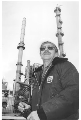
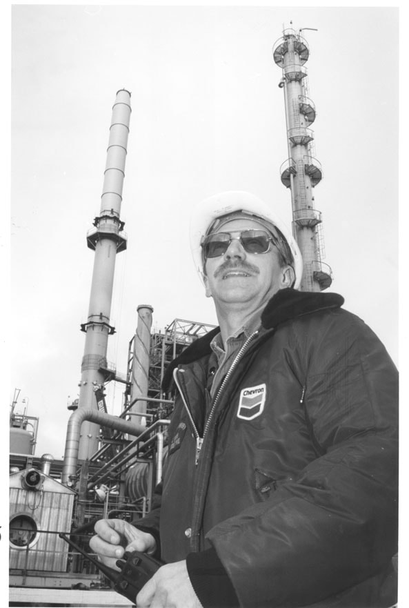
Chevron Refinery
https://search.heritageburnaby.ca/link/archivedescription79805
- Repository
- City of Burnaby Archives
- Date
- December 18, 1996
- Collection/Fonds
- Burnaby NewsLeader photograph collection
- Description Level
- Item
- Physical Description
- 1 photograph : b&w ; 22.5 x 15 cm
- Scope and Content
- Photograph of an unidentified man wearing a Chevron jacket and hard hat at the Chevron refinery.
- Repository
- City of Burnaby Archives
- Date
- December 18, 1996
- Collection/Fonds
- Burnaby NewsLeader photograph collection
- Physical Description
- 1 photograph : b&w ; 22.5 x 15 cm
- Description Level
- Item
- Record No.
- 535-0523
- Access Restriction
- No restrictions
- Reproduction Restriction
- No reproduction permitted
- Accession Number
- 2012-11
- Scope and Content
- Photograph of an unidentified man wearing a Chevron jacket and hard hat at the Chevron refinery.
- Subjects
- Buildings - Industrial - Refineries
- Media Type
- Photograph
- Photographer
- Langdeau, Brian
- Notes
- Title based on contents of photograph
- Note in black ink on recto of photograph reads: "72% Bby p. 15 / Brian 3123 Bby A"
- Trim marks and/or reproduction instructions on recto (scan is cropped)
- Man in photograph has been identified has Kenneth Leduc.
Images
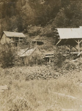
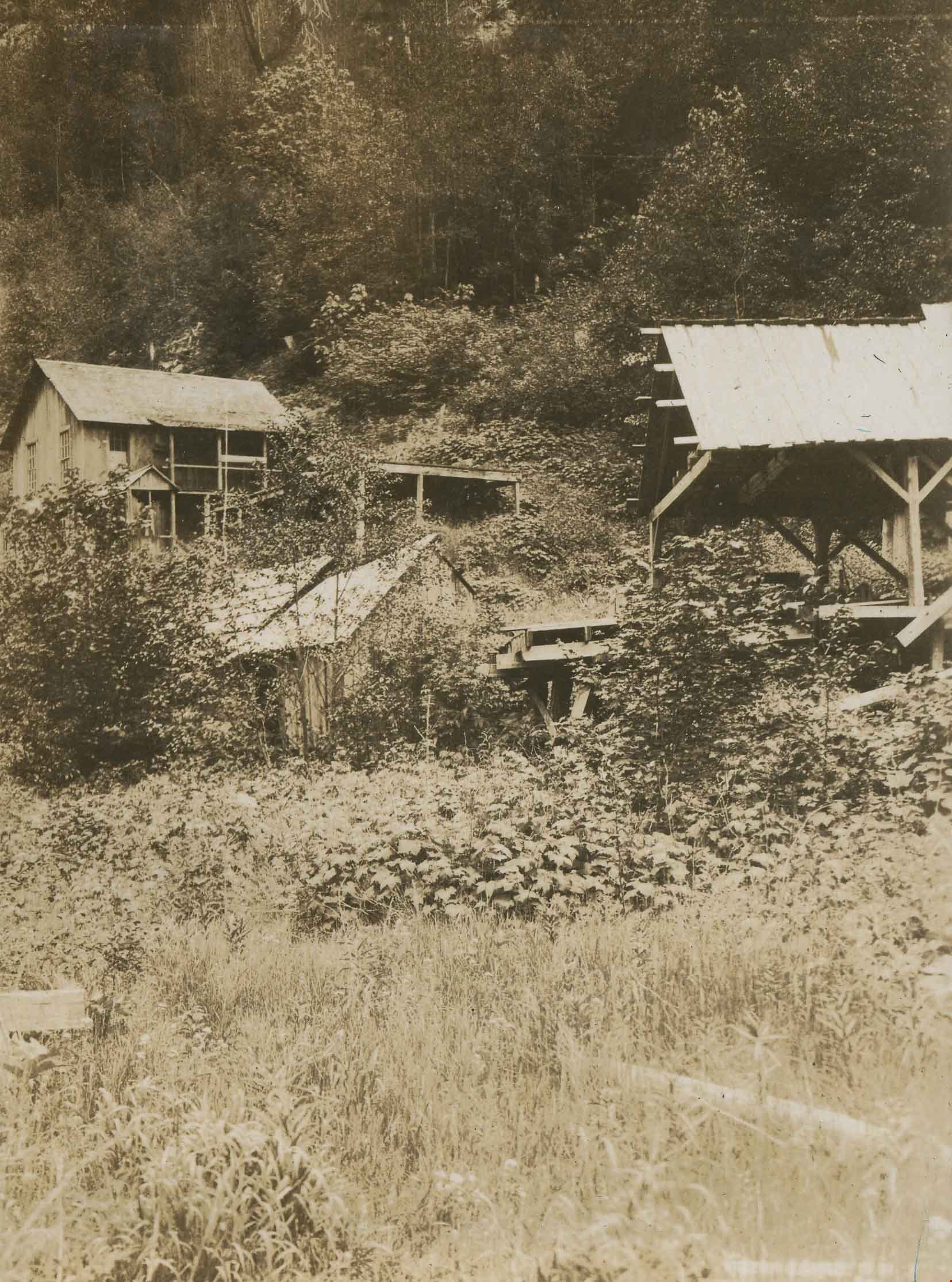
Dumbolten's on Siwash Creek
https://search.heritageburnaby.ca/link/archivedescription34370
- Repository
- City of Burnaby Archives
- Date
- 1925
- Collection/Fonds
- Burnaby Historical Society fonds
- Description Level
- Item
- Physical Description
- 1 photograph : b&w ; 7 x 9.5 cm on page 17.5 x 26.3 cm
- Scope and Content
- Photograph is identified by the caption as being "Dumbolten's on Siwash Creek" with a number of wooden buildings and structures built on the side of a hill. This photograph appears to have been taken by Arthur Peers, who travelled through the Fraser River Valley and worked on the construction of th…
- Repository
- City of Burnaby Archives
- Date
- 1925
- Collection/Fonds
- Burnaby Historical Society fonds
- Subseries
- Peers family subseries
- Physical Description
- 1 photograph : b&w ; 7 x 9.5 cm on page 17.5 x 26.3 cm
- Description Level
- Item
- Record No.
- 020-077
- Access Restriction
- No restrictions
- Reproduction Restriction
- No known restrictions
- Accession Number
- BHS2007-04
- Scope and Content
- Photograph is identified by the caption as being "Dumbolten's on Siwash Creek" with a number of wooden buildings and structures built on the side of a hill. This photograph appears to have been taken by Arthur Peers, who travelled through the Fraser River Valley and worked on the construction of the Trans-Provincial Highway during the later 1920s.
- Subjects
- Buildings - Industrial
- Media Type
- Photograph
- Photographer
- Peers, Arthur Francis "Mike"
- Notes
- Title based on caption accompanying photograph
Images