Narrow Results By
Subject
- Animals 1
- Animals - Birds 1
- Buildings - Religious - Churches 10
- Buildings - Schools 16
- Businesses - Real Estate Agencies 1
- Documentary Artifacts 4
- Documentary Artifacts - Booklets 5
- Documentary Artifacts - Books 2
- Documentary Artifacts - Leaflets 1
- Emergency Measures - Civil Defence 1
- First Nations reserves - British Columbia 3
- Foods 1
Creator
- Adams, Edith 1
- Adams, John 2
- British Columbia Underwriters' Association 1
- Burnett and McGugan B.C. Land Surveyors, New Westminster 5
- Burnett, Geoffrey K. 5
- Burnett & McGugan, Engineers and Surveyors 20
- Canada. Office of the Director of Civil Air Raid Precautions 1
- Coast Map and Blue Print Co. 1
- Cody, Henry John, 1868-1951 3
- D. Jayne and Son 1
- Draper, William Nelson 1
- Eaton's 1
Person / Organization
- All Saints Anglican Church 1
- Armstrong Avenue School 1
- Barnet School 1
- Broadview Presbyterian Church 1
- Burnett, Geoffrey K. 2
- Ceperley, H.T. 2
- Chapman, Nina Christina Atkinson 1
- Corsbie, Joseph Hardcastle-Cumberland "Joe" 1
- Douglas Road School 1
- Dundonald United Church 1
- East Burnaby Methodist Church, 1904-1925 1
- Edmonds Community School 2
![All Saints Church, [ca.1910] thumbnail](/media/hpo/_Data/_BVM_Cartographic_Material/2003/2003_0083_0046_001.jpg?width=280)
All Saints Church
https://search.heritageburnaby.ca/link/museumdescription11924
- Repository
- Burnaby Village Museum
- Date
- [ca.1910]
- Collection/Fonds
- Ronald G. Scobbie collection
- Description Level
- Item
- Physical Description
- 1 plan : black ink and watercol. on paper ; 30.45 x 30.5 cm
- Scope and Content
- Item consists of building insurance plan of "All Saints Church / Lot "A" BK 29 DL 98 GP1 N.W.D.". Watling Street is idenfied to the north of the church building and Royal Oak Avenue to the west.
- Repository
- Burnaby Village Museum
- Collection/Fonds
- Ronald G. Scobbie collection
- Description Level
- Item
- Physical Description
- 1 plan : black ink and watercol. on paper ; 30.45 x 30.5 cm
- Material Details
- Scale 1 inch = 20 feet
- Scope and Content
- Item consists of building insurance plan of "All Saints Church / Lot "A" BK 29 DL 98 GP1 N.W.D.". Watling Street is idenfied to the north of the church building and Royal Oak Avenue to the west.
- Subjects
- Buildings - Religious - Churches
- Accession Code
- BV003.83.46
- Access Restriction
- No restrictions
- Reproduction Restriction
- No known restrictions
- Date
- [ca.1910]
- Media Type
- Cartographic Material
- Scan Resolution
- 600
- Scan Date
- 15-Jan-2021
- Scale
- 100
- Notes
- Transcribed title
- Note in pencil on verso reads: ""All Saints Church / Lot "A" BK 29 DL 98 / Scale 1 inch = 20 feet"
- Note in balck in on verso reads: "3704"
Images
![All Saints Church, [ca.1910] thumbnail](/media/hpo/_Data/_BVM_Cartographic_Material/2003/2003_0083_0046_001.jpg)
Almanack for 1884
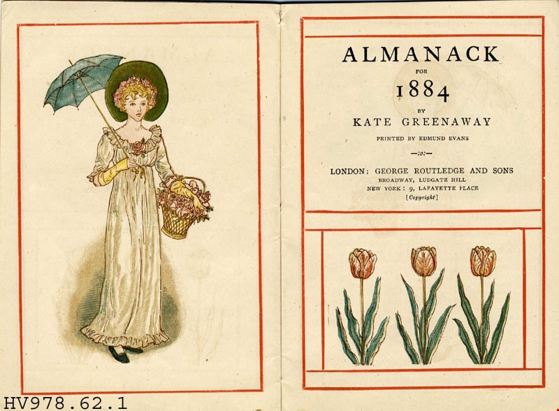
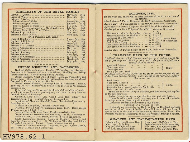
https://search.heritageburnaby.ca/link/museumlibrary4883
- Repository
- Burnaby Village Museum
- Author
- Greenaway, Kate, 1846-1901
- Publication Date
- 1884
- Call Number
- 310 GRE
- Repository
- Burnaby Village Museum
- Collection
- Special Collection
- Material Type
- Book
- Accession Code
- HV978.62.1
- Call Number
- 310 GRE
- Author
- Greenaway, Kate, 1846-1901
- Place of Publication
- London
- Publisher
- George Routledge and Sons
- Publication Date
- 1884
- Printer
- Edmund Evans
- Physical Description
- 1 v. (unpaged) : col. ill. : 14 cm.
- Library Subject (LOC)
- Natural history
- Months
- Seasons
- Almanacs
- Miniature books--Specimens
- Juvenile literature
- Notes
- "printed by Edmund Evans".
- Printer' s dates: Evans, Edmund, 1826-1905.
Images

![Anglican Church, [ca.1910] thumbnail](/media/hpo/_Data/_BVM_Cartographic_Material/2003/2003_0083_0043_001.jpg?width=280)
Anglican Church
https://search.heritageburnaby.ca/link/museumdescription11921
- Repository
- Burnaby Village Museum
- Date
- [ca.1910]
- Collection/Fonds
- Ronald G. Scobbie collection
- Description Level
- Item
- Physical Description
- 1 plan : black ink and watercol. on paper ; 30.45 x 30.5 cm
- Scope and Content
- Item consists of building insurance plan of "Anglican Church / Lot 2 BK 37 DL69, GP.1, N.W.D. (15th Ave. (Dominion) is identified to the north of Lots 1, 2 and 3).
- Repository
- Burnaby Village Museum
- Collection/Fonds
- Ronald G. Scobbie collection
- Description Level
- Item
- Physical Description
- 1 plan : black ink and watercol. on paper ; 30.45 x 30.5 cm
- Material Details
- Scale 1 inch = 20 feet
- Scope and Content
- Item consists of building insurance plan of "Anglican Church / Lot 2 BK 37 DL69, GP.1, N.W.D. (15th Ave. (Dominion) is identified to the north of Lots 1, 2 and 3).
- Subjects
- Buildings - Religious - Churches
- Accession Code
- BV003.83.43
- Access Restriction
- No restrictions
- Reproduction Restriction
- No known restrictions
- Date
- [ca.1910]
- Media Type
- Cartographic Material
- Scan Resolution
- 600
- Scan Date
- 15-Jan-2021
- Scale
- 100
- Notes
- Transcribed title
- Note in pencil on verso reads: "Anglican Church / Lot 2 Bk 37 DL69 / 1"=20' "
- Note in balck in on verso reads: "3704"
Images
![Anglican Church, [ca.1910] thumbnail](/media/hpo/_Data/_BVM_Cartographic_Material/2003/2003_0083_0043_001.jpg)

Armstrong Street School site
https://search.heritageburnaby.ca/link/museumdescription11133
- Repository
- Burnaby Village Museum
- Date
- 1915
- Collection/Fonds
- Ronald G. Scobbie collection
- Description Level
- Item
- Physical Description
- 1 survey plan : blueprint on paper ; 56 x 54 cm
- Scope and Content
- Survey plan of "Armstrong Street School Site / Burnaby Municipality" "Being a 2 acre portion of Lot 13 Group 1, & according to map 1722 which shows this as Lot E. Block 2 of subdivision of a portion, of Lot 13, Group 1, New Westminster District".
- Repository
- Burnaby Village Museum
- Collection/Fonds
- Ronald G. Scobbie collection
- Description Level
- Item
- Physical Description
- 1 survey plan : blueprint on paper ; 56 x 54 cm
- Material Details
- Scale 40 feet = 1 inch
- Scope and Content
- Survey plan of "Armstrong Street School Site / Burnaby Municipality" "Being a 2 acre portion of Lot 13 Group 1, & according to map 1722 which shows this as Lot E. Block 2 of subdivision of a portion, of Lot 13, Group 1, New Westminster District".
- Creator
- Burnett, Geoffrey K.
- Subjects
- Buildings - Schools
- Names
- Armstrong Avenue School
- Responsibility
- Burnett & McGugan, Engineers and Surveyors
- Geographic Access
- Armstrong Avenue
- Street Address
- 8757 Armstrong Avenue
- Accession Code
- BV003.83.12
- Access Restriction
- No restrictions
- Reproduction Restriction
- No known restrictions
- Date
- 1915
- Media Type
- Cartographic Material
- Historic Neighbourhood
- East Burnaby (Historic Neighbourhood)
- Planning Study Area
- Cariboo-Armstrong Area
- Scan Resolution
- 440
- Scan Date
- 22-Dec-2020
- Scale
- 100
- Notes
- Title based on contents of plan
- Note in black ink on verso of plan reads: "1746"
- Oath on plan reads: "I, Geoffrey K. Burnett...and did personally superintend the survey represented..." "Completed on the 18th day of March 1915"; signed by Geoffrey K. Burnett and notarized by "K.A. Eastman", sworn "...19th day of April 1915"; "Burnett and McGugan., B.C. Land Surveyors. Etc.. New Westminster, B.C.."
Zoomable Images


Barnet School site
https://search.heritageburnaby.ca/link/museumdescription11140
- Repository
- Burnaby Village Museum
- Date
- May 27, 1915
- Collection/Fonds
- Ronald G. Scobbie collection
- Description Level
- Item
- Physical Description
- 1 survey plan : blueprint on paper ; 56 x 54 cm
- Scope and Content
- Survey plan of "Barnet School Site / Burnaby Municipality" "Being a portion of the west half of lot / 214, Group 1 / New Westminster District”.
- Repository
- Burnaby Village Museum
- Collection/Fonds
- Ronald G. Scobbie collection
- Description Level
- Item
- Physical Description
- 1 survey plan : blueprint on paper ; 56 x 54 cm
- Material Details
- Scale 40 feet = 1 inch
- Scope and Content
- Survey plan of "Barnet School Site / Burnaby Municipality" "Being a portion of the west half of lot / 214, Group 1 / New Westminster District”.
- Creator
- McGugan, Donald Johnston
- Subjects
- Buildings - Schools
- Names
- Barnet School
- Responsibility
- Burnett & McGugan, Engineers and Surveyors
- Geographic Access
- Barnet Road
- Street Address
- 7820 Barnet Road
- Accession Code
- BV003.83.19
- Access Restriction
- No restrictions
- Reproduction Restriction
- No known restrictions
- Date
- May 27, 1915
- Media Type
- Cartographic Material
- Historic Neighbourhood
- Barnet (Historic Neighbourhood)
- Planning Study Area
- Burnaby Mountain Area
- Scan Resolution
- 440
- Scan Date
- 22-Dec-2020
- Scale
- 100
- Notes
- Title based on contents of plan
- handwritten on back "Burnaby Schools" "23R" twice, "1783"
- Oath on plan reads: "I, D.J. McGugan...and did personally superintend the survey..." "completed on the 27th day of May 1915"; signed by D.J. McGugan, notarized by "Walter Edmonds" "sworn "...29th day of May 1915" "Burnett and McGugan" "B.C. Land Surveyors Etc. New Westminster, B.C.";
Zoomable Images

![Bird's eye view of New Westminster, Burnaby and Vancouver, [ca. 1911] thumbnail](/media/hpo/_Data/_BVM_Cartographic_Material/1983/1983_0012_0001_002%20Web.jpg?width=280)
Bird's eye view of New Westminster, Burnaby and Vancouver
https://search.heritageburnaby.ca/link/museumdescription8199
- Repository
- Burnaby Village Museum
- Date
- [ca. 1911]
- Collection/Fonds
- Burnaby Village Museum Map collection
- Description Level
- Item
- Physical Description
- 1 map : hand painted ; 65.5 x 99 cm
- Scope and Content
- An untitled monochromatic grayscale map of a developer's bird's eye view looking north west from Burnaby Mountain. View includes Burnaby, New Westminster, Vancouver with the North shore in the distance. Burnaby neighbourhood subdivisions of "Burnaby Heights" and "Buena Vista" are featured near the…
- Repository
- Burnaby Village Museum
- Collection/Fonds
- Burnaby Village Museum Map collection
- Description Level
- Item
- Physical Description
- 1 map : hand painted ; 65.5 x 99 cm
- Scope and Content
- An untitled monochromatic grayscale map of a developer's bird's eye view looking north west from Burnaby Mountain. View includes Burnaby, New Westminster, Vancouver with the North shore in the distance. Burnaby neighbourhood subdivisions of "Burnaby Heights" and "Buena Vista" are featured near the centre of the map. These neighbourhood subdivisions were marketed by Real Estate Agents Liebly & Blumer in 1911. Roads, buildings, factories, railways and bridges are identified on the map.
- Subjects
- Businesses - Real Estate Agencies
- Responsibility
- Leibly & Blumer Realty Co. Incorporated
- Accession Code
- HV983.12.1
- Access Restriction
- No restrictions
- Reproduction Restriction
- No known restrictions
- Date
- [ca. 1911]
- Media Type
- Cartographic Material
- Historic Neighbourhood
- East Burnaby (Historic Neighbourhood)
- Vancouver Heights (Historic Neighbourhood)
- Planning Study Area
- Cariboo-Armstrong Area
- Burnaby Heights Area
- Scan Resolution
- 300
- Scan Date
- December 2020
- Scale
- 100
- Notes
- Title based on contents of map
- Note in pencil on verso of photograph reads: "Make tint block of Buena Vista / Blocks only as shown in lots"
Zoomable Images
![Bird's eye view of New Westminster, Burnaby and Vancouver, [ca. 1911] thumbnail](/media/hpo/_Data/_BVM_Cartographic_Material/1983/1983_0012_0001_001_seadragon/1983_0012_0001_001.jpg?w=280)

Bird's Eye View of the Burnaby Lake Area
https://search.heritageburnaby.ca/link/museumdescription15144
- Repository
- Burnaby Village Museum
- Date
- 1977
- Collection/Fonds
- Century Park Museum Association fonds
- Description Level
- Item
- Physical Description
- 1 map : b&w print on paper ; 43 x 63.5 cm
- Scope and Content
- Item consists of a map titled "Birds Eye View of the Burnaby Lake Area Circa 1910". The overview of the Burnaby Lake area was compiled and drawn at Heritage Village by curator John Adams and artist, Carol Swan. The map identifies the Burnaby Lake inter-urban tram line; roads including: Sperling Ave…
- Repository
- Burnaby Village Museum
- Collection/Fonds
- Century Park Museum Association fonds
- Description Level
- Item
- Physical Description
- 1 map : b&w print on paper ; 43 x 63.5 cm
- Material Details
- Scale indeterminable
- Scope and Content
- Item consists of a map titled "Birds Eye View of the Burnaby Lake Area Circa 1910". The overview of the Burnaby Lake area was compiled and drawn at Heritage Village by curator John Adams and artist, Carol Swan. The map identifies the Burnaby Lake inter-urban tram line; roads including: Sperling Avenue (Pole Line Road); Gilpin Avenue; Douglas Road; trail to Vancouver Westminster Road (Kingsway); Buckingham Avenue; Haszard Street; various farms and residences including: Charles Sprott "Norland"; H.T. Ceperley "Fairacres"; Claude Hill's "Brookfield farm" and "Broadview"; F.J. Hart's "Avalon"; Miss Woodward's former and new home, school and post office; Councillor Edgar's hunting cabin; Edgar Sprott's "Mayfield farm" and "Mayfield Lodge"; F.J. Peers "Greyfriars"; Arthur de Windt Haszard; Bernard Hill's boathouse as well as other landmarks including: Doran's Mill; tram stations; Burnaby Lake Store; logging camps; wood cutter's shacks; ice houses; cranberry bog; Still Creek; Deer Lake; Burnaby Lake; Deer Lake Creek; Provincial Government Reserve Proposed Hospital (later Oakalla Prison).
- Creator
- Adams, John
- Swan, Carol
- Names
- Hill, Arthur Claude
- Sprott, Charles Frederick
- Sprott, Louis "Edgar"
- Hart, Frederick John, 1884-1945
- Ceperley, H.T.
- Woodward, Maude
- Woodward, Harriet
- Peers, Francis J.
- Haszard, Arthur de Windt
- Hill, Bernard R.
- Geographic Access
- Deer Lake Avenue
- Sperling Avenue
- Haszard Street
- Buckingham Avenue
- Accession Code
- BV021.1.3
- Access Restriction
- No restrictions
- Reproduction Restriction
- No known restrictions
- Date
- 1977
- Media Type
- Cartographic Material
- Historic Neighbourhood
- Burnaby Lake (Historic Neighbourhood)
- Planning Study Area
- Burnaby Lake Area
- Related Material
- See also: Life with the Moores of Hart House : pioneer days on Burnaby's Deer Lake
- Scan Resolution
- 600
- Scan Date
- 2021-11-12
- Scale
- 100
- Notes
- Transcribed title
- Compiled by John Adams; illustration by Carol Swan
- The map depicts the Burnaby Lake Tram Line as being double tracked, whereas in reality it was single tracked.
- Map is part of the book "Life with the Moores of Hart House : pioneer days on Burnaby's Deer Lake https://search.heritageburnaby.ca/permalink/museumlibrary6314-102
Images


Bird's Eye View of the Burnaby Lake Area
https://search.heritageburnaby.ca/link/museumdescription17543
- Repository
- Burnaby Village Museum
- Date
- 1977
- Collection/Fonds
- Century Park Museum Association fonds
- Description Level
- Item
- Physical Description
- 1 map : b&w print with watercolour ; 43 x 63.5 cm
- Scope and Content
- Item consists of a map titled "Birds Eye View of the Burnaby Lake Area Circa 1910". The overview of the Burnaby Lake area was compiled and drawn at Heritage Village by curator John Adams and artist, Carol Swan. The map identifies the Burnaby Lake inter-urban tram line; roads including: Sperling Ave…
- Repository
- Burnaby Village Museum
- Collection/Fonds
- Century Park Museum Association fonds
- Description Level
- Item
- Physical Description
- 1 map : b&w print with watercolour ; 43 x 63.5 cm
- Material Details
- Scale indeterminable
- Scope and Content
- Item consists of a map titled "Birds Eye View of the Burnaby Lake Area Circa 1910". The overview of the Burnaby Lake area was compiled and drawn at Heritage Village by curator John Adams and artist, Carol Swan. The map identifies the Burnaby Lake inter-urban tram line; roads including: Sperling Avenue (Pole Line Road); Gilpin Avenue; Douglas Road; trail to Vancouver Westminster Road (Kingsway); Buckingham Avenue; Haszard Street; various farms and residences including: Charles Sprott "Norland"; H.T. Ceperley "Fairacres"; Claude Hill's "Brookfield farm" and "Broadview"; F.J. Hart's "Avalon"; Miss Woodward's former and new home, school and post office; Councillor Edgar's hunting cabin; Edgar Sprott's "Mayfield farm" and "Mayfield Lodge"; F.J. Peers "Greyfriars"; Arthur de Windt Haszard; Bernard Hill's boathouse as well as other landmarks including: Doran's Mill; tram stations; Burnaby Lake Store; logging camps; wood cutter's shacks; ice houses; cranberry bog; Still Creek; Deer Lake; Burnaby Lake; Deer Lake Creek; Provincial Government Reserve Proposed Hospital (later Oakalla Prison).
- Creator
- Adams, John
- Swan, Carol
- Names
- Hill, Arthur Claude
- Sprott, Charles Frederick
- Sprott, Louis "Edgar"
- Hart, Frederick John, 1884-1945
- Ceperley, H.T.
- Woodward, Maude
- Woodward, Harriet
- Peers, Francis J.
- Haszard, Arthur de Windt
- Hill, Bernard R.
- Geographic Access
- Deer Lake Avenue
- Sperling Avenue
- Haszard Street
- Buckingham Avenue
- Accession Code
- BV021.1.4
- Access Restriction
- No restrictions
- Reproduction Restriction
- No known restrictions
- Date
- 1977
- Media Type
- Cartographic Material
- Historic Neighbourhood
- Burnaby Lake (Historic Neighbourhood)
- Planning Study Area
- Burnaby Lake Area
- Related Material
- See also: Life with the Moores of Hart House : pioneer days on Burnaby's Deer Lake
- Scan Resolution
- 600
- Scan Date
- 2021-11-12
- Scale
- 100
- Notes
- Transcribed title
- Compiled by John Adams; illustration by Carol Swan
- The map depicts the Burnaby Lake Tram Line as being double tracked, whereas in reality it was single tracked.
- Map is part of the book "Life with the Moores of Hart House : pioneer days on Burnaby's Deer Lake https://search.heritageburnaby.ca/permalink/museumlibrary6314-102
- This is a print made from original illustration and appears to be hand-coloured with watercolour at a later date.
Images


Book of birds
https://search.heritageburnaby.ca/link/museumlibrary4819
- Repository
- Burnaby Village Museum
- Collection
- Special Collection
- Material Type
- Book
- Accession Code
- BV985.6170.1
- Call Number
- 598 BOO
- Place of Publication
- London
- Publisher
- Ernest Nister
- Publication Date
- 1914
- Physical Description
- 1 v. (unpaged) : col. ill. : 27 cm.
- Inscription
- "Ma___ Burd from Nancy Bompa Xmas 1914" [Handwritten in pencil on front endpaper]
- Library Subject (LOC)
- Birds
- Juvenile literature
- Children's literature
- Animals
- Subjects
- Animals - Birds
- Animals
Images


The book of knowledge : the children's encyclopaedia, volume i
https://search.heritageburnaby.ca/link/museumlibrary668
- Repository
- Burnaby Village Museum
- Collection
- Special Collection
- Material Type
- Book
- Accession Code
- BV985.3668.1
- Call Number
- 032 MEE v. 1 1918
- Contributor
- Mee, Arthur, 1875-1943
- Thompson, Holland, 1873-1940
- Finley, John H. (John Huston), 1863-1940
- Place of Publication
- New York
- Publisher
- The Grolier Society
- Publication Date
- c1918
- Series
- The Book of Knowledge, v. 1
- Physical Description
- x, 334 p. : ill. : 25 cm.
- Library Subject (LOC)
- Encyclopedias and dictionaries
- Children's encyclopædias and dictionaries
- Notes
- "Editors-in-chief Arthur Mee...Holland Thompson..." -- Title page
- "With an introduction by John H. Finley..." -- Title page
- Contributor's full name and dates: Finley, John H. (John Huston), 1863-1940
- page 1-334
- Volume 1 of 20
Images

The book of knowledge : the children's encyclopaedia, volume ii
https://search.heritageburnaby.ca/link/museumlibrary669
- Repository
- Burnaby Village Museum
- Collection
- Special Collection
- Material Type
- Book
- Accession Code
- BV985.3668.2
- Call Number
- 032 MEE v.2 1918
- Contributor
- Mee, Arthur, 1875-1943
- Thompson, Holland, 1873-1940
- Finley, John H. (John Huston), 1863-1940
- Place of Publication
- New York
- Publisher
- The Grolier Society
- Publication Date
- c1918
- Series
- The Book of Knowledge, v. 2
- Physical Description
- 335-660 p. : ill. : 25 cm.
- Library Subject (LOC)
- Encyclopedias and dictionaries
- Children's encyclopædias and dictionaries
- Notes
- "Editors-in-chief Arthur Mee...Holland Thompson..." -- Title page
- "With an introduction b John H. Findley..." -- Title page
- Contributor's full name and dates: Finley, John H. (John Huston), 1863-1940
- pages 335-660
- volume 2 of 20
Images
The book of knowledge : the children's encyclopaedia, volume iii
https://search.heritageburnaby.ca/link/museumlibrary670
- Repository
- Burnaby Village Museum
- Collection
- Special Collection
- Material Type
- Book
- Accession Code
- BV985.3668.3
- Call Number
- 032 MEE v. 3 1918
- Contributor
- Mee, Arthur, 1875-1943
- Thompson, Holland, 1873-1940
- Finley, John H. (John Huston), 1863-1940
- Place of Publication
- New York
- Publisher
- The Grolier Society
- Publication Date
- c1918
- Series
- The Book of Knowledge, v. 3
- Physical Description
- 662-992 p. : ill.(some col.) : 25 cm.
- Inscription
- "Gross 1955 3 on R Gross" [Handwritten in blue ink on back flyleaf]
- Library Subject (LOC)
- Encyclopedias and dictionaries
- Children's encyclopædias and dictionaries
- Notes
- "Editors-in-chief Arthur Mee...Holland Thompson..." -- Title page
- "With an introduction by John H. Finley..." -- Title page
- Contributor's full name and dates: Finley, John H. (John Huston), 1863-1940
- pages 662-992
- volume 3 of 20
Images
The book of knowledge : the children's encyclopaedia, volume iv
https://search.heritageburnaby.ca/link/museumlibrary671
- Repository
- Burnaby Village Museum
- Collection
- Special Collection
- Material Type
- Book
- Accession Code
- BV985.3668.4
- Call Number
- 032 MEE v.4 1918
- Contributor
- Mee, Arthur, 1875-1943
- Thompson, Holland, 1873-1940
- Finley, John H. (John Huston), 1863-1940
- Place of Publication
- New York
- Publisher
- The Grolier Society
- Publication Date
- c1918
- Series
- The Book of Knowledge, v. 4
- Physical Description
- 993-1312 : ill. : 25 cm.
- Library Subject (LOC)
- Encyclopedias and dictionaries
- Children's encyclopædias and dictionaries
- Notes
- "Editors-in-chief Arthur Mee...Holland Thompson..." -- Title page
- "With an introduction by John H. Finley..." -- Title page
- Contributor's full name and dates: Finley, John H. (John Huston), 1863-1940
- pages 993-1312
- volume 4 of 20
Images
The book of knowledge : the children's encyclopaedia, volume v
https://search.heritageburnaby.ca/link/museumlibrary672
- Repository
- Burnaby Village Museum
- Collection
- Special Collection
- Material Type
- Book
- Accession Code
- BV985.3668.5
- Call Number
- 032 MEE v.5 1918
- Contributor
- Mee, Arthur, 1875-1943
- Thompson, Holland, 1873-1940
- Finley, John H. (John Huston), 1863-1940
- Place of Publication
- New York
- Publisher
- The Grolier Society
- Publication Date
- c1918
- Series
- The Book of Knowledge, v. 5
- Physical Description
- 1313-1638 p. : ill. : 25 cm.
- Library Subject (LOC)
- Encyclopedias and dictionaries
- Children's encyclopædias and dictionaries
- Notes
- "Editors-in-chief Arthur Mee...Holland Thompson..." -- Title page
- "With and introduction by John H. Finley..." -- Title page
- Contributor's full name and dates: Finley, John H. (John Huston), 1863-1940
- pages 1313-1638
- volume 5 of 20
Images
The book of knowledge : the children's encyclopaedia, volume vi
https://search.heritageburnaby.ca/link/museumlibrary673
- Repository
- Burnaby Village Museum
- Collection
- Special Collection
- Material Type
- Book
- Accession Code
- BV985.3668.6
- Call Number
- 032 MEE v. 6 1918
- Contributor
- Mee, Arthur, 1875-1943
- Thompson, Holland, 1873-1940
- Finley, John H. (John Huston), 1863-1940
- Place of Publication
- New York
- Publisher
- The Grolier Society
- Publication Date
- c1918
- Series
- The Book of Knowledge, v. 6
- Physical Description
- iv, 1639-1958, : ill. : 25 cm.
- Library Subject (LOC)
- Encyclopedias and dictionaries
- Children's encyclopædias and dictionaries
- Notes
- "Editors-in-chief Arthur Mee...Holland Thompson..." -- Title page
- "With an introduction by John H. Finley..." -- Title page
- Contributor's full name and dates: Finley, John H. (John Huston), 1863-1940
- pages 1639-1958
- volume 6 of 20
Images
The book of knowledge : the children's encyclopaedia, volume vii
https://search.heritageburnaby.ca/link/museumlibrary674
- Repository
- Burnaby Village Museum
- Collection
- Special Collection
- Material Type
- Book
- Accession Code
- BV985.3668.7
- Call Number
- 032 MEE v. 7 1918
- Place of Publication
- New York
- Publisher
- The Grolier Society
- Publication Date
- c1918
- 1919
- Series
- The Book of Knowledge, v. 7
- Physical Description
- iv, 1959-2278 : ill. : 25 cm.
- Library Subject (LOC)
- Encyclopedias and dictionaries
- Children's encyclopædias and dictionaries
- Notes
- "Editors-in-chief Arthur Mee...Holland Thompson..." -- Title page
- "With an introduction by John H. Finley..." -- Title page
- Contributor's full name and dates: Finley, John H. (John Huston), 1863-1940
- pages 1959-2278
- volume 7 of 20
Images
The book of knowledge : the children's encyclopaedia, volume viii
https://search.heritageburnaby.ca/link/museumlibrary675
- Repository
- Burnaby Village Museum
- Collection
- Special Collection
- Material Type
- Book
- Accession Code
- BV985.3668.8
- Call Number
- 032 MEE v.8 1918
- Place of Publication
- New York
- Publisher
- The Grolier Society
- Publication Date
- c1918
- Series
- The Book of Knowledge, v. 8
- Physical Description
- iv, 2279-2610 : ill. : 26 cm.
- Library Subject (LOC)
- Encyclopedias and dictionaries
- Children's encyclopædias and dictionaries
- Notes
- "Editors-in-chief Arthur Mee...Holland Thompson..." -- Title page
- "With an introduction by John H. Finley..." -- Title page
- Contributor's full name and dates: Finley, John H. (John Huston), 1863-1940
- page 2279-2610
- volume 8 of 20
Images
The book of knowledge : the children's encyclopaedia : volume xix
https://search.heritageburnaby.ca/link/museumlibrary684
- Repository
- Burnaby Village Museum
- Collection
- Special Collection
- Material Type
- Book
- Accession Code
- BV985.3668.17
- Call Number
- 032 MEE v.19 1918
- Place of Publication
- New York
- Publisher
- Grolier Society
- Publication Date
- c1918
- Physical Description
- 327 p. : ill. ; 25 cm.
- Library Subject (LOC)
- Encyclopedias and dictionaries
- Children's encyclopædias and dictionaries
- Notes
- paged 5875 - 6202.
Images
The book of knowledge : the children's encyclopaedia : volume xviii
https://search.heritageburnaby.ca/link/museumlibrary683
- Repository
- Burnaby Village Museum
- Collection
- Special Collection
- Material Type
- Book
- Accession Code
- BV985.3668.16
- Call Number
- 032 MEE v.18 1918
- Place of Publication
- New York
- Publisher
- Grolier Society
- Publication Date
- c1918
- Series
- The book of knowledge
- Physical Description
- 323 p. : ill. ; 25 cm.
- Inscription
- "R Paul G" [handwritten in pencil onpage opposite front pastedown] "Paul Hofer" [handwritten in pencil on title page]
- Library Subject (LOC)
- Encyclopedias and dictionaries
- Children's encyclopædias and dictionaries
- Notes
- paged 5551 - 5874.
Images
The book of knowledge : the children's encyclopaedia : volume xx
https://search.heritageburnaby.ca/link/museumlibrary685
- Repository
- Burnaby Village Museum
- Collection
- Special Collection
- Material Type
- Book
- Accession Code
- BV985.3668.18
- Call Number
- 032 MEE v.20 1918
- Place of Publication
- New York
- Publisher
- Grolier Society
- Publication Date
- c1918
- Physical Description
- 379 p. : ill. ; 25 cm.
- Inscription
- Scribbles in pencil on back pastedown and opposing page
- Library Subject (LOC)
- Encyclopedias and dictionaries
- Children's encyclopædias and dictionaries
- Notes
- paged 6203 - 6582.
- Includes index.
Images
The book of knowledge : the children's encyclopædia, vol. 17
https://search.heritageburnaby.ca/link/museumlibrary682
- Repository
- Burnaby Village Museum
- Collection
- Special Collection
- Material Type
- Book
- Accession Code
- BV985.3668.15
- Call Number
- 032 MEE v.17
- Contributor
- Mee, Arthur, 1875-1943
- Thompson, Holland, 1873-1940
- Finley, John H. (John Huston), 1863-1940
- Place of Publication
- New York
- Publisher
- The Grolier Society
- Publication Date
- c1918
- Series
- The Book of Knowledge
- Physical Description
- 322 p. : ill
- Library Subject (LOC)
- Children's encyclopædias and dictionaries
- Notes
- pages numbered 5228-5550
- Contributors' given names, dates and contribution:
- Mee, Arthur, 1875-1943. (editor-in-chief)
- Thompson, Holland, 1873-1940. (editor-in-chief)
- "with an introduction by John H. Finley, LLD Late President of the College of New York Commissioner of Education of the State of New York"
Images

Boys of the Bible
https://search.heritageburnaby.ca/link/museumlibrary5848
- Repository
- Burnaby Village Museum
- Collection
- Special Collection
- Material Type
- Book
- Accession Code
- BV007.31.5
- Call Number
- 220.9 BOY
- Contributor
- Turner, A. M.
- Place of Publication
- New York
- Publisher
- Sam'l Gabriel Sons & Co.
- Publication Date
- c1916
- Physical Description
- 32 p. : ill. : 28 cm.
- Inscription
- "Presented to Nina Atkinson for Proficiency in bible study and general aptitude: from The East Burnaby Methodist Sunday School August 1917" [Handwritten in pencil on front flyleaf]
- Library Subject (LOC)
- Bible
- Bible. Old Testament
- Juvenile literature
- Notes
- "Illustrated by A. M. Turner" -- Title page
Images

![Broadview Presbyterian Church, [ca.1910] thumbnail](/media/hpo/_Data/_BVM_Cartographic_Material/2003/2003_0083_0049_001.jpg?width=280)
Broadview Presbyterian Church
https://search.heritageburnaby.ca/link/museumdescription11927
- Repository
- Burnaby Village Museum
- Date
- [ca.1910]
- Collection/Fonds
- Ronald G. Scobbie collection
- Description Level
- Item
- Physical Description
- 1 plan : black ink and watercol. on paper ; 30.45 x 30.5 cm
- Scope and Content
- Item consists of building insurance plan of "Broadview Presbyterian Church / Lot 6, BK 31, DL 69 / GP1 N.W.D." . Fourteenth Avenue (Manor) is identified to the north and Douglas Ave. to the east.
- Repository
- Burnaby Village Museum
- Collection/Fonds
- Ronald G. Scobbie collection
- Description Level
- Item
- Physical Description
- 1 plan : black ink and watercol. on paper ; 30.45 x 30.5 cm
- Material Details
- Scale 1 inch = 20 feet
- Scope and Content
- Item consists of building insurance plan of "Broadview Presbyterian Church / Lot 6, BK 31, DL 69 / GP1 N.W.D." . Fourteenth Avenue (Manor) is identified to the north and Douglas Ave. to the east.
- Subjects
- Buildings - Religious - Churches
- Accession Code
- BV003.83.49
- Access Restriction
- No restrictions
- Reproduction Restriction
- No known restrictions
- Date
- [ca.1910]
- Media Type
- Cartographic Material
- Scan Resolution
- 600
- Scan Date
- 15-Jan-2021
- Scale
- 100
- Notes
- Transcribed title
- Note in pencil on verso reads: "Broadview Presbyterian Church / Lot 6, BK 31, DL 69 / 1" = 20' "
- Note in balck in on verso reads: "3704"
Images
![Broadview Presbyterian Church, [ca.1910] thumbnail](/media/hpo/_Data/_BVM_Cartographic_Material/2003/2003_0083_0049_001.jpg)
Bygones of Burnaby : an anecdotal history
https://search.heritageburnaby.ca/link/museumlibrary5462
- Repository
- Burnaby Village Museum
- Author
- McGeachie, Pixie, 1921-
- Publication Date
- 1976
- c1975
- Call Number
- 971.133 MCG COPY 4
- Repository
- Burnaby Village Museum
- Collection
- Digital Reference Collection
- Material Type
- Book
- Call Number
- 971.133 MCG COPY 4
- Author
- McGeachie, Pixie, 1921-
- Place of Publication
- Burnaby, B.C.
- Publisher
- Century Park Museum Association
- Publication Date
- 1976
- c1975
- Physical Description
- 108 p. : ill. ; 23 cm.
- Library Subject (LOC)
- Burnaby (B.C.)--History
- Notes
- 4 copies held: copy 4.
Digital Books

Douglas Road School site
https://search.heritageburnaby.ca/link/museumdescription11136
- Repository
- Burnaby Village Museum
- Date
- April 19, 1915
- Collection/Fonds
- Ronald G. Scobbie collection
- Description Level
- Item
- Physical Description
- 1 survey plan : blueprint on paper ; 56 x 54 cm
- Scope and Content
- Survey plan of "Douglas Road School Site / Burnaby Municipality" "Being Lot 21, of Blocks 1-5 inc. 11 & 12 of the subd. of north half of Lot 80, Group 1, New Westminster District".
- Repository
- Burnaby Village Museum
- Collection/Fonds
- Ronald G. Scobbie collection
- Description Level
- Item
- Physical Description
- 1 survey plan : blueprint on paper ; 56 x 54 cm
- Material Details
- Scale 40 feet = 1 inch
- Scope and Content
- Survey plan of "Douglas Road School Site / Burnaby Municipality" "Being Lot 21, of Blocks 1-5 inc. 11 & 12 of the subd. of north half of Lot 80, Group 1, New Westminster District".
- Creator
- McGugan, Donald Johnston
- Subjects
- Buildings - Schools
- Names
- Douglas Road School
- Responsibility
- Burnett & McGugan, Engineers and Surveyors
- Geographic Access
- Canada Way
- Street Address
- 4861 Canada Way
- Accession Code
- BV003.83.15
- Access Restriction
- No restrictions
- Reproduction Restriction
- No known restrictions
- Date
- April 19, 1915
- Media Type
- Cartographic Material
- Historic Neighbourhood
- Burnaby Lake (Historic Neighbourhood)
- Planning Study Area
- Douglas-Gilpin Area
- Scan Resolution
- 440
- Scan Date
- 22-Dec-2020
- Scale
- 100
- Notes
- Title based on contents of plan
- Note in black ink on verso of plan reads: "1747"
- Oath on plan reads: "I, D.G. McGugan..." "...and did person- ally superintend the survey..." "...completed on the 3rd day of April 1915"; signed by D.J. McGugan, notarized by "H.A. Eastman", sworn "...19th day of April 1915" "Burnett and McGugan" "B.C. Land Surveyors Etc. New Westminster, B.C.."
Images
