Narrow Results By
Subject
- Agriculture - Fruit and Berries 1
- Animals - Horses 2
- Buildings - Agricultural - Nurseries 1
- Buildings - Commercial 2
- Buildings - Commercial - Theatres 1
- Buildings - Industrial - Mills 1
- Buildings - Religious 1
- Cemeteries 1
- Construction - Road Construction 1
- Construction Tools and Equipment 1
- Documentary Artifacts - Certificates 2
- Education 4
Person / Organization
- Ansdell, Elsie Brown-John 1
- Bingham, Alfred "Alf" 4
- Bobic, Janice 2
- Bolton, Richard 1
- Bradbury, Dr. Bettina 15
- British Columbia Hydro and Power Authority 1
- Brown-John, Victor Joseph Charles 1
- Brown-John, Winnifred Douglas 1
- Burnaby Art Gallery 1
- Burnaby Village Museum 2
- Cafferky, Emmet J. 1
- Canada Summer Games 1

Chapel Of Peace
https://search.heritageburnaby.ca/link/landmark566
- Repository
- Burnaby Heritage Planning
- Description
- Church building.
- Associated Dates
- 1936
- Formal Recognition
- Heritage Designation, Community Heritage Register
- Other Names
- First United Spiritualist Church
- Street View URL
- Google Maps Street View
- Repository
- Burnaby Heritage Planning
- Other Names
- First United Spiritualist Church
- Geographic Access
- Kincaid Street
- Associated Dates
- 1936
- Formal Recognition
- Heritage Designation, Community Heritage Register
- Enactment Type
- Bylaw No. 13162
- Enactment Date
- 28/01/2013
- Description
- Church building.
- Heritage Value
- This church was built in 1936 as the Chapel of Peace for the Forest Lawn Cemetery. It was located outside the main entrance of the cemetery at the triangular parcel of land bounded by Sprott, Royal Oak and Canada Way. It served as the location for many memorial services, local community worship and weddings. The Anglican Church purchased and relocated the building to its present site in 1955. The church has been altered with the addition of wings and stucco, but retains its steep front gabled roof and some of its arched windows. It is now used as the First United Spiritualist Church.
- Locality
- Burnaby Lake
- Historic Neighbourhood
- Burnaby Lake (Historic Neighbourhood)
- Planning Study Area
- Douglas-Gilpin Area
- Contributing Resource
- Building
- Ownership
- Private
- Street Address
- 5584 Kincaid Street
- Street View URL
- Google Maps Street View
Images


Ford Motor Company
https://search.heritageburnaby.ca/link/landmark698
- Repository
- Burnaby Heritage Planning
- Geographic Access
- Kingsway
- Associated Dates
- 1938
- Heritage Value
- In 1938, the Ford Motor Company selected Burnaby as its site for a new assembly plant to serve Western Canada. Ford purchased the land which had been owned by the Silver family at Kingsway and Silver Avenue and built its factory using steel from Burnaby's Dominion Bridge Company. During World War II, the plant was used to produce military vehicles. In 1988, the building was demolished and the Station Square development was constructed on the site.
- Historic Neighbourhood
- Central Park (Historic Neighbourhood)
- Planning Study Area
- Maywood Area
- Street Address
- 4600 Kingsway
Images


Westridge Neighbourhood
https://search.heritageburnaby.ca/link/landmark680
- Repository
- Burnaby Heritage Planning
- Associated Dates
- 1925-1954
- Heritage Value
- The Westridge Neighbourhood of Burnaby was created as a new subdivision during the post-World War Two housing boom in Burnaby. Developed by the C.B. Riley Company, it was laid out in a plan contoured to the shapes of the land and was situated to allow residents easy access to main transportation routes.
- Historic Neighbourhood
- Lochdale (Historic Neighbourhood)
- Planning Study Area
- Westridge Area
Images

![Rae Weir clearing land, [193-] (date of original), copied 1986 thumbnail](/media/hpo/_Data/_Archives_Images/_Unrestricted/204/204-173.jpg?width=280)
Rae Weir clearing land
https://search.heritageburnaby.ca/link/archivedescription35316
- Repository
- City of Burnaby Archives
- Date
- [193-] (date of original), copied 1986
- Collection/Fonds
- Burnaby Historical Society fonds
- Description Level
- Item
- Physical Description
- 1 photograph : b&w ; 12.7 x 17.8 cm print
- Scope and Content
- Photograph of Rae Weir clearing a lot on Jubilee Avenue with a D4 Caterpillar bulldozer. Rae Weir owned Jubilee Fuel and Transfer which did everything from clearing lots to excavating basements to delivering and selling fuels.
- Repository
- City of Burnaby Archives
- Date
- [193-] (date of original), copied 1986
- Collection/Fonds
- Burnaby Historical Society fonds
- Subseries
- Pioneer Tales subseries
- Physical Description
- 1 photograph : b&w ; 12.7 x 17.8 cm print
- Description Level
- Item
- Record No.
- 204-173
- Access Restriction
- No restrictions
- Reproduction Restriction
- No known restrictions
- Accession Number
- BHS1988-03
- Scope and Content
- Photograph of Rae Weir clearing a lot on Jubilee Avenue with a D4 Caterpillar bulldozer. Rae Weir owned Jubilee Fuel and Transfer which did everything from clearing lots to excavating basements to delivering and selling fuels.
- Media Type
- Photograph
- Notes
- Title based on contents of photograph
- Geographic Access
- Jubilee Avenue
- Historic Neighbourhood
- Central Park (Historic Neighbourhood)
- Planning Study Area
- Maywood Area
Images
![Rae Weir clearing land, [193-] (date of original), copied 1986 thumbnail](/media/hpo/_Data/_Archives_Images/_Unrestricted/204/204-173.jpg)
![Standard Oil land clearing, [1935] (date of original), copied 1986 thumbnail](/media/hpo/_Data/_Archives_Images/_Unrestricted/204/204-043.jpg?width=280)
Standard Oil land clearing
https://search.heritageburnaby.ca/link/archivedescription35186
- Repository
- City of Burnaby Archives
- Date
- [1935] (date of original), copied 1986
- Collection/Fonds
- Burnaby Historical Society fonds
- Description Level
- Item
- Physical Description
- 1 photograph : b&w ; 12.7 x 17.8 cm print
- Scope and Content
- Photograph of land being cleared for the Standard Oil Refinery in North Burnaby. The refinery was commonly call Stanovan and was located at the foot of Queens Avenue (now Willingdon street). This later became the site of Chevron's Stanovan plant at 4403 Eton Street.
- Repository
- City of Burnaby Archives
- Date
- [1935] (date of original), copied 1986
- Collection/Fonds
- Burnaby Historical Society fonds
- Subseries
- Pioneer Tales subseries
- Physical Description
- 1 photograph : b&w ; 12.7 x 17.8 cm print
- Description Level
- Item
- Record No.
- 204-043
- Access Restriction
- No restrictions
- Reproduction Restriction
- No known restrictions
- Accession Number
- BHS1988-03
- Scope and Content
- Photograph of land being cleared for the Standard Oil Refinery in North Burnaby. The refinery was commonly call Stanovan and was located at the foot of Queens Avenue (now Willingdon street). This later became the site of Chevron's Stanovan plant at 4403 Eton Street.
- Subjects
- Land Clearing
- Media Type
- Photograph
- Notes
- Title based on contents of photograph
- Geographic Access
- Eton Street
- Street Address
- 4403 Eton Street
- Historic Neighbourhood
- Vancouver Heights (Historic Neighbourhood)
- Planning Study Area
- Burnaby Heights Area
Images
![Standard Oil land clearing, [1935] (date of original), copied 1986 thumbnail](/media/hpo/_Data/_Archives_Images/_Unrestricted/204/204-043.jpg)

Alfred Bingham's writings - Track 1
https://search.heritageburnaby.ca/link/oralhistory251
- Repository
- City of Burnaby Archives
- Date Range
- 1865-1919
- Length
- 0:10:18
- Summary
- This portion of the recording includes Alfred Bingham's essay entitled Stump Rangers, a listing of early settlers that includes addresses and short descriptions, essays on Confederation Park, land clearing and on Burnaby's first Council meeting.
- Repository
- City of Burnaby Archives
- Summary
- This portion of the recording includes Alfred Bingham's essay entitled Stump Rangers, a listing of early settlers that includes addresses and short descriptions, essays on Confederation Park, land clearing and on Burnaby's first Council meeting.
- Date Range
- 1865-1919
- Photo Info
- Alfred Bingham, April 20, 1947. Item no. 010-066
- Length
- 0:10:18
- Scope and Content
- Recording is of Alfred Bingham's writings, as read by Alfred Bingham. Major themes discussed are: Pioneers, early days in Burnaby and the Co-op Movement. To view "Narrow By" terms for each track expand this description and see "Notes".
- Biographical Notes
- Alfred "Alf" Bingham was born in England in 1892 and moved to Canada in 1912. His first job in Canada was laying track for the Grand Trunk Pacific Railway (GTPR) from Edmonton to McBride in 1912. His second was in Vancouver at the Rat Portage Mill on False Creek, working on the Resaw machine. He quit after one week due to poor working conditions. After taking part in the 1919 Winnipeg General Strike as a delegate of the Retail and Mailorder Union (A.F.L.) on the Winnipeg Trades and Labour Council, Alfred moved to Burnaby where he and fellow Burnaby residents Aungus McLean and Percy Little worked ten hour days to build a Shingle Mill on the edge of Burnaby Lake for Simpson & Giberson. George Green, carpenter and millwright (author of “The History of Burnaby”) also helped in the construction of the mill. Alfred built his own home from lumber cut from the mill in the Lochdale area on Sherlock Street between Curtis Street and Kitchener Street. On April 10, 1920 Alfred married Mary Jane “Ada” Reynolds. Alfred and Ada often took in foster children during their marriage. Due to her nursing experience, Ada was often called upon to deliver babies in the Burnaby area. Alfred and Ada Bingham were instrumental members of the Army of the Common Good, collecting vegetables and grains from growers in the area and even producing over 125 tons of vegetables from its own gardens to feed children and youth suffering from the lack of resources during the Depression years. The army was in operation for ten years and during that time the members organised the Credit Union movement of British Columbia and drew up the Credit Union act thorough the Vancouver Co-operative Council. They also started Co-Op stores and the Co-Op Wholesale Society. Alfred was also Secretary of the Burnaby Housing committee and in 1946 he became the Secretary of the North Burnaby Labour Progressive Party (LPP). Mary Jane “Ada” (Reynolds) Bingham died on August 9, 1969. Her husband Alfred died on April 29, 1979.
- Total Tracks
- 12
- Total Length
- 1:38:06
- Interviewee Name
- Bingham, Alfred "Alf"
- Collection/Fonds
- Burnaby Historical Society fonds
- Subseries
- Oral history subseries
- Transcript Available
- MSS142-001 contains transcripts for each of the short stories
- Media Type
- Sound Recording
- Web Notes
- Interview was digitized in 2010 allowing it to be accessible on Heritage Burnaby. The digitization project was initiated by the Community Heritage Commission with support from City of Burnaby Council and the BC History Digitization Program of the Irving K. Barber Learning Centre, University of British Columbia. It was recognized by the Heritage Society of BC with an award in 2012.
Images

Audio Tracks
Track one of recording of Alfred Bingham's writings
Track one of recording of Alfred Bingham's writings
https://search.heritageburnaby.ca/media/hpo/_Data/_Archives_Oral_Histories/_Unrestricted/100-13-20-2/100-13-20-2_Track_1.mp3
Alfred Bingham's writings - Track 2
https://search.heritageburnaby.ca/link/oralhistory252
- Repository
- City of Burnaby Archives
- Date Range
- 1919-1955
- Length
- 0:06:06
- Summary
- This portion of the recording includes Alfred Bingham's memories of constructing a mill for Simpson & Giberson and of working on homes for himself, Angus McLean and Percy Little in the Lochdale area. He discusses the strike at Barnet mill and reads an essay written by Grace E. Carpenter. Land clear…
- Repository
- City of Burnaby Archives
- Summary
- This portion of the recording includes Alfred Bingham's memories of constructing a mill for Simpson & Giberson and of working on homes for himself, Angus McLean and Percy Little in the Lochdale area. He discusses the strike at Barnet mill and reads an essay written by Grace E. Carpenter. Land clearing is described in detail. Alfred also relates a story from 1920 involving early settlers E. Powell and J. Amos.
- Date Range
- 1919-1955
- Photo Info
- Alfred Bingham, April 20, 1947. Item no. 010-066
- Length
- 0:06:06
- Historic Neighbourhood
- Lochdale (Historic Neighbourhood)
- Planning Study Area
- Lochdale Area
- Scope and Content
- Recording is of Alfred Bingham's writings, as read by Alfred Bingham. Major themes discussed are: Pioneers, early days in Burnaby and the Co-op Movement. To view "Narrow By" terms for each track expand this description and see "Notes".
- Biographical Notes
- Alfred "Alf" Bingham was born in England in 1892 and moved to Canada in 1912. His first job in Canada was laying track for the Grand Trunk Pacific Railway (GTPR) from Edmonton to McBride in 1912. His second was in Vancouver at the Rat Portage Mill on False Creek, working on the Resaw machine. He quit after one week due to poor working conditions. After taking part in the 1919 Winnipeg General Strike as a delegate of the Retail and Mailorder Union (A.F.L.) on the Winnipeg Trades and Labour Council, Alfred moved to Burnaby where he and fellow Burnaby residents Aungus McLean and Percy Little worked ten hour days to build a Shingle Mill on the edge of Burnaby Lake for Simpson & Giberson. George Green, carpenter and millwright (author of “The History of Burnaby”) also helped in the construction of the mill. Alfred built his own home from lumber cut from the mill in the Lochdale area on Sherlock Street between Curtis Street and Kitchener Street. On April 10, 1920 Alfred married Mary Jane “Ada” Reynolds. Alfred and Ada often took in foster children during their marriage. Due to her nursing experience, Ada was often called upon to deliver babies in the Burnaby area. Alfred and Ada Bingham were instrumental members of the Army of the Common Good, collecting vegetables and grains from growers in the area and even producing over 125 tons of vegetables from its own gardens to feed children and youth suffering from the lack of resources during the Depression years. The army was in operation for ten years and during that time the members organised the Credit Union movement of British Columbia and drew up the Credit Union act thorough the Vancouver Co-operative Council. They also started Co-Op stores and the Co-Op Wholesale Society. Alfred was also Secretary of the Burnaby Housing committee and in 1946 he became the Secretary of the North Burnaby Labour Progressive Party (LPP). Mary Jane “Ada” (Reynolds) Bingham died on August 9, 1969. Her husband Alfred died on April 29, 1979.
- Total Tracks
- 12
- Total Length
- 1:38:06
- Interviewee Name
- Bingham, Alfred "Alf"
- Collection/Fonds
- Burnaby Historical Society fonds
- Subseries
- Oral history subseries
- Transcript Available
- MSS142-001 contains transcripts for each of the short stories
- Media Type
- Sound Recording
- Web Notes
- Interview was digitized in 2010 allowing it to be accessible on Heritage Burnaby. The digitization project was initiated by the Community Heritage Commission with support from City of Burnaby Council and the BC History Digitization Program of the Irving K. Barber Learning Centre, University of British Columbia. It was recognized by the Heritage Society of BC with an award in 2012.
Images
Audio Tracks
Track two of recording of Alfred Bingham's writings
Track two of recording of Alfred Bingham's writings
https://search.heritageburnaby.ca/media/hpo/_Data/_Archives_Oral_Histories/_Unrestricted/100-13-20-2/100-13-20-2_Track_2.mp3
Alfred Bingham's writings - Track 3
https://search.heritageburnaby.ca/link/oralhistory253
- Repository
- City of Burnaby Archives
- Date Range
- 1903-1940
- Length
- 0:09:46
- Summary
- This portion of the recording includes Alfred Bingham's descriptions of road construction in Burnaby, including the names of the settlers and logging companies involved in their construction. Alfred discusses the changes that took place during World War I, along with municipal Relief work that he t…
- Repository
- City of Burnaby Archives
- Summary
- This portion of the recording includes Alfred Bingham's descriptions of road construction in Burnaby, including the names of the settlers and logging companies involved in their construction. Alfred discusses the changes that took place during World War I, along with municipal Relief work that he took part in at Burnaby Mountain. Alfred also discusses early schools and mentions his wife, Ada Bingham.
- Date Range
- 1903-1940
- Photo Info
- Alfred Bingham, April 20, 1947. Item no. 010-066
- Length
- 0:09:46
- Planning Study Area
- Burnaby Mountain Area
- Scope and Content
- Recording is of Alfred Bingham's writings, as read by Alfred Bingham. Major themes discussed are: Pioneers, early days in Burnaby and the Co-op Movement. To view "Narrow By" terms for each track expand this description and see "Notes".
- Biographical Notes
- Alfred "Alf" Bingham was born in England in 1892 and moved to Canada in 1912. His first job in Canada was laying track for the Grand Trunk Pacific Railway (GTPR) from Edmonton to McBride in 1912. His second was in Vancouver at the Rat Portage Mill on False Creek, working on the Resaw machine. He quit after one week due to poor working conditions. After taking part in the 1919 Winnipeg General Strike as a delegate of the Retail and Mailorder Union (A.F.L.) on the Winnipeg Trades and Labour Council, Alfred moved to Burnaby where he and fellow Burnaby residents Aungus McLean and Percy Little worked ten hour days to build a Shingle Mill on the edge of Burnaby Lake for Simpson & Giberson. George Green, carpenter and millwright (author of “The History of Burnaby”) also helped in the construction of the mill. Alfred built his own home from lumber cut from the mill in the Lochdale area on Sherlock Street between Curtis Street and Kitchener Street. On April 10, 1920 Alfred married Mary Jane “Ada” Reynolds. Alfred and Ada often took in foster children during their marriage. Due to her nursing experience, Ada was often called upon to deliver babies in the Burnaby area. Alfred and Ada Bingham were instrumental members of the Army of the Common Good, collecting vegetables and grains from growers in the area and even producing over 125 tons of vegetables from its own gardens to feed children and youth suffering from the lack of resources during the Depression years. The army was in operation for ten years and during that time the members organised the Credit Union movement of British Columbia and drew up the Credit Union act thorough the Vancouver Co-operative Council. They also started Co-Op stores and the Co-Op Wholesale Society. Alfred was also Secretary of the Burnaby Housing committee and in 1946 he became the Secretary of the North Burnaby Labour Progressive Party (LPP). Mary Jane “Ada” (Reynolds) Bingham died on August 9, 1969. Her husband Alfred died on April 29, 1979.
- Total Tracks
- 12
- Total Length
- 1:38:06
- Interviewee Name
- Bingham, Alfred "Alf"
- Collection/Fonds
- Burnaby Historical Society fonds
- Subseries
- Oral history subseries
- Transcript Available
- MSS142-001 contains transcripts for each of the short stories
- Media Type
- Sound Recording
- Web Notes
- Interview was digitized in 2010 allowing it to be accessible on Heritage Burnaby. The digitization project was initiated by the Community Heritage Commission with support from City of Burnaby Council and the BC History Digitization Program of the Irving K. Barber Learning Centre, University of British Columbia. It was recognized by the Heritage Society of BC with an award in 2012.
Images
Audio Tracks
Track three of recording of Alfred Bingham's writings
Track three of recording of Alfred Bingham's writings
https://search.heritageburnaby.ca/media/hpo/_Data/_Archives_Oral_Histories/_Unrestricted/100-13-20-2/100-13-20-2_Track_3.mp3
Alfred Bingham's writings - Track 7
https://search.heritageburnaby.ca/link/oralhistory257
- Repository
- City of Burnaby Archives
- Date Range
- 1919-1939
- Length
- 0:09:44
- Summary
- This portion of the recording includes Alfred Bingham's continuation of reading his series of short stories. He reads "WHAT THE LOCHDALE DISTRICT LOOKED LIKE IN 1919-20-21-22" and "1st and SECOND SETTLERS IN THE LOCHDALE DISTRICT" both written in 1963.
- Repository
- City of Burnaby Archives
- Summary
- This portion of the recording includes Alfred Bingham's continuation of reading his series of short stories. He reads "WHAT THE LOCHDALE DISTRICT LOOKED LIKE IN 1919-20-21-22" and "1st and SECOND SETTLERS IN THE LOCHDALE DISTRICT" both written in 1963.
- Date Range
- 1919-1939
- Photo Info
- Alfred Bingham, April 20, 1947. Item no. 010-066
- Length
- 0:09:44
- Subjects
- Land Clearing
- Historic Neighbourhood
- Lochdale (Historic Neighbourhood)
- Planning Study Area
- Burnaby Mountain Area
- Scope and Content
- Recording is of Alfred Bingham's writings, as read by Alfred Bingham. Major themes discussed are: Pioneers, early days in Burnaby and the Co-op Movement. To view "Narrow By" terms for each track expand this description and see "Notes".
- Biographical Notes
- Alfred "Alf" Bingham was born in England in 1892 and moved to Canada in 1912. His first job in Canada was laying track for the Grand Trunk Pacific Railway (GTPR) from Edmonton to McBride in 1912. His second was in Vancouver at the Rat Portage Mill on False Creek, working on the Resaw machine. He quit after one week due to poor working conditions. After taking part in the 1919 Winnipeg General Strike as a delegate of the Retail and Mailorder Union (A.F.L.) on the Winnipeg Trades and Labour Council, Alfred moved to Burnaby where he and fellow Burnaby residents Aungus McLean and Percy Little worked ten hour days to build a Shingle Mill on the edge of Burnaby Lake for Simpson & Giberson. George Green, carpenter and millwright (author of “The History of Burnaby”) also helped in the construction of the mill. Alfred built his own home from lumber cut from the mill in the Lochdale area on Sherlock Street between Curtis Street and Kitchener Street. On April 10, 1920 Alfred married Mary Jane “Ada” Reynolds. Alfred and Ada often took in foster children during their marriage. Due to her nursing experience, Ada was often called upon to deliver babies in the Burnaby area. Alfred and Ada Bingham were instrumental members of the Army of the Common Good, collecting vegetables and grains from growers in the area and even producing over 125 tons of vegetables from its own gardens to feed children and youth suffering from the lack of resources during the Depression years. The army was in operation for ten years and during that time the members organised the Credit Union movement of British Columbia and drew up the Credit Union act thorough the Vancouver Co-operative Council. They also started Co-Op stores and the Co-Op Wholesale Society. Alfred was also Secretary of the Burnaby Housing committee and in 1946 he became the Secretary of the North Burnaby Labour Progressive Party (LPP). Mary Jane “Ada” (Reynolds) Bingham died on August 9, 1969. Her husband Alfred died on April 29, 1979.
- Total Tracks
- 12
- Total Length
- 1:38:06
- Interviewee Name
- Bingham, Alfred "Alf"
- Collection/Fonds
- Burnaby Historical Society fonds
- Subseries
- Oral history subseries
- Transcript Available
- MSS142-001 contains transcripts for each of the short stories
- Media Type
- Sound Recording
- Web Notes
- Interview was digitized in 2010 allowing it to be accessible on Heritage Burnaby. The digitization project was initiated by the Community Heritage Commission with support from City of Burnaby Council and the BC History Digitization Program of the Irving K. Barber Learning Centre, University of British Columbia. It was recognized by the Heritage Society of BC with an award in 2012.
Images
Audio Tracks
Track seven of recording of Alfred Bingham's writings
Track seven of recording of Alfred Bingham's writings
https://search.heritageburnaby.ca/media/hpo/_Data/_Archives_Oral_Histories/_Unrestricted/100-13-20-2/100-13-20-2_Track_7.mp3![Barkerville in the '30s, [193-] thumbnail](/media/hpo/_Data/_Archives_Images/_Unrestricted/001/020-060.jpg?width=280)
Barkerville in the '30s
https://search.heritageburnaby.ca/link/archivedescription34353
- Repository
- City of Burnaby Archives
- Date
- [193-]
- Collection/Fonds
- Burnaby Historical Society fonds
- Description Level
- Item
- Physical Description
- 1 photograph : b&w ; 7.2 x 12 cm on page 17.5 x 26.5 cm
- Scope and Content
- Photograph of the town of Barkerville. Barkerville was a central town during the Cariboo Gold Rush. Photograph shows the town with a hill being cleared in the background. This photograph appears to have been taken by Arthur Peers, who travelled through the Fraser River Valley and worked on the c…
- Repository
- City of Burnaby Archives
- Date
- [193-]
- Collection/Fonds
- Burnaby Historical Society fonds
- Subseries
- Peers family subseries
- Physical Description
- 1 photograph : b&w ; 7.2 x 12 cm on page 17.5 x 26.5 cm
- Description Level
- Item
- Record No.
- 020-060
- Access Restriction
- No restrictions
- Reproduction Restriction
- No known restrictions
- Accession Number
- BHS2007-04
- Scope and Content
- Photograph of the town of Barkerville. Barkerville was a central town during the Cariboo Gold Rush. Photograph shows the town with a hill being cleared in the background. This photograph appears to have been taken by Arthur Peers, who travelled through the Fraser River Valley and worked on the construction of the Trans-Provincial Highway during the later 1920s.
- Media Type
- Photograph
- Photographer
- Peers, Arthur Francis "Mike"
- Notes
- Title based on caption accompanying photograph
Images
![Barkerville in the '30s, [193-] thumbnail](/media/hpo/_Data/_Archives_Images/_Unrestricted/001/020-060.jpg)
![Capitol Hill, [193-] (date of original), copied 1986 thumbnail](/media/hpo/_Data/_Archives_Images/_Unrestricted/126/189-001.jpg?width=280)
Capitol Hill
https://search.heritageburnaby.ca/link/archivedescription35080
- Repository
- City of Burnaby Archives
- Date
- [193-] (date of original), copied 1986
- Collection/Fonds
- Burnaby Historical Society fonds
- Description Level
- Item
- Physical Description
- 1 photograph : b&w ; 10.0 x 15.2 cm print
- Scope and Content
- Photograph of a logging road on the north face of Capitol Hill. Burrard Inlet can be seen in the background. An annotation in the photograph register describes it as a "road cut to take timber on side hill for destitute family's heat and cooking."
- Repository
- City of Burnaby Archives
- Date
- [193-] (date of original), copied 1986
- Collection/Fonds
- Burnaby Historical Society fonds
- Subseries
- Marjorie Coe subseries
- Physical Description
- 1 photograph : b&w ; 10.0 x 15.2 cm print
- Description Level
- Item
- Record No.
- 189-001
- Access Restriction
- No restrictions
- Reproduction Restriction
- No known restrictions
- Accession Number
- BHS1986-40
- Scope and Content
- Photograph of a logging road on the north face of Capitol Hill. Burrard Inlet can be seen in the background. An annotation in the photograph register describes it as a "road cut to take timber on side hill for destitute family's heat and cooking."
- Subjects
- Geographic Features - Roads
- Land Clearing
- Media Type
- Photograph
- Notes
- Title based on contents of photograph
- Historic Neighbourhood
- Capitol Hill (Historic Neighbourhood)
- Planning Study Area
- Capitol Hill Area
Images
![Capitol Hill, [193-] (date of original), copied 1986 thumbnail](/media/hpo/_Data/_Archives_Images/_Unrestricted/126/189-001.jpg)
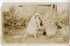
Dorothy Easthope
https://search.heritageburnaby.ca/link/archivedescription97969
- Repository
- City of Burnaby Archives
- Date
- 1930
- Collection/Fonds
- Burnaby Historical Society fonds
- Description Level
- Item
- Physical Description
- 1 photograph : col. ; 9 cm x 14 cm
- Scope and Content
- Photograph of Dorothy Easthope outside the original house at 6671 Halifax Street. She is posing for the camera while sawing a large cut tree on the property.
- Repository
- City of Burnaby Archives
- Date
- 1930
- Collection/Fonds
- Burnaby Historical Society fonds
- Subseries
- Easthope family subseries
- Physical Description
- 1 photograph : col. ; 9 cm x 14 cm
- Description Level
- Item
- Record No.
- 451-036
- Access Restriction
- No restrictions
- Reproduction Restriction
- No known restrictions
- Accession Number
- BHS2003-06
- Scope and Content
- Photograph of Dorothy Easthope outside the original house at 6671 Halifax Street. She is posing for the camera while sawing a large cut tree on the property.
- Subjects
- Land Clearing
- Media Type
- Photograph
- Notes
- Title based on contents of photograph
- Note in black ink on verso of photograph reads: "Dorothy Easthope ca. 1930 6671 Halifax St."
- Geographic Access
- Halifax Street
- Street Address
- 6671 Halifax Street
- Historic Neighbourhood
- Lochdale (Historic Neighbourhood)
- Planning Study Area
- Lochdale Area
Images

![Elsie Brown-John (bottom, far right) with her class at Kitchener Street School, [1936]. Item no. 549-001. thumbnail](/media/hpo/_Data/_Archives_Images/_Unrestricted/540/549-001.jpg?width=280)
Interview with Elsie Ansdell by Eric Damer September 18, 2012 - Track 1
https://search.heritageburnaby.ca/link/oralhistory287
- Repository
- City of Burnaby Archives
- Date Range
- 1910-1946
- Length
- 0:09:17
- Summary
- This portion of the recording pertains to the Brown-Johns first settling in Burnaby. Elsie (Brown-John) Ansdell discusses land clearing for the family home, each of her parents and her brothers.
- Repository
- City of Burnaby Archives
- Summary
- This portion of the recording pertains to the Brown-Johns first settling in Burnaby. Elsie (Brown-John) Ansdell discusses land clearing for the family home, each of her parents and her brothers.
- Date Range
- 1910-1946
- Photo Info
- Elsie Brown-John (bottom, far right) with her class at Kitchener Street School, [1936]. Item no. 549-001.
- Length
- 0:09:17
- Subjects
- Land Clearing
- Geographic Access
- Napier Street
- Historic Neighbourhood
- Vancouver Heights (Historic Neighbourhood)
- Planning Study Area
- Willingdon Heights Area
- Interviewer
- Damer, Eric
- Interview Date
- September 18, 2012
- Scope and Content
- Recording is an interview with early Burnaby resident Elsie (Brown-John) Ansdell conducted by Burnaby Village Museum employee Eric Damer, September 18, 2012. Major themes discussed are: settling in Burnaby and the early years of the Brown-John family.
- Biographical Notes
- Elsie (Brown-John) Ansdell’s father, a trained carpenter and cabinet maker, Victor Brown-John came to Canada from Wales in 1910. He cleared three lots at Napier and Gilmore Streets and built a two-roomed house. In 1912, he was joined by his wife and two eldest sons, Victor and Archie. Twin boys, Frank and Roy, were born in 1914 in the Burnaby home and their fifth son, Clive, was born in 1915. From 1916 to 1919 Victor John-Brown left Burnaby to serve overseas. Elsie Brown-John (later Ansdell) was born in 1921. Her younger brother, Gwyn "Jerry" was born in 1923. In 1925 Victor Brown-John suffered a fatal accident while working as a longshoreman in Northern British Columbia. Elsie attended Kitchener Elementary and North Burnaby High School. She married during the Second World War and moved to South Burnaby to raise her family whilst continuing to work in various department stores both in Vancouver and Burnaby.
- Total Tracks
- 4
- Total Length
- 33:02
- Interviewee Name
- Ansdell, Elsie Brown-John
- Interview Location
- Burnaby Village Museum
- Interviewer Bio
- Eric Damer is a lifelong British Columbian born in Victoria, raised in Kamloops, and currently residing in Burnaby. After studying philosophy at the University of Victoria, he became interested in the educational forces that had shaped his own life. He completed master’s and doctoral degrees in educational studies at the University of British Columbia with a particular interest in the history of adult and higher education in the province. In 2012, Eric worked for the City of Burnaby as a field researcher and writer, conducting interviews for the City Archives and Museum Oral History Program.
- Collection/Fonds
- Community Heritage Commission Special Projects fonds
- Transcript Available
- None
- Media Type
- Sound Recording
Images
![Elsie Brown-John (bottom, far right) with her class at Kitchener Street School, [1936]. Item no. 549-001. thumbnail](/media/hpo/_Data/_Archives_Images/_Unrestricted/540/549-001.jpg)
Audio Tracks
Track one of recording of interview with Elsie Ansdell
Track one of recording of interview with Elsie Ansdell
https://search.heritageburnaby.ca/media/hpo/_Data/_Archives_Oral_Histories/_Unrestricted/MSS171-001/MSS171-001_Track_1.mp3
Indigenous History in Burnaby Resource Guide
https://search.heritageburnaby.ca/link/museumlibrary7493
- Repository
- Burnaby Village Museum
- Edition
- First
- Publication Date
- 2019
- Call Number
- 971.100497 BVM
- Repository
- Burnaby Village Museum
- Collection
- Digital Reference Collection
- Material Type
- Digital Resource
- Accession Code
- BV019.64.1
- Call Number
- 971.100497 BVM
- Edition
- First
- Contributor
- Kwantlen First Nation
- Sḵwx̱wú7mesh First Nation
- Tsleil-Waututh First Nation
- ʷməθkʷəy̓əm (Musqueam) First Nation
- Place of Publication
- Burnaby, BC
- Publisher
- City of Burnaby
- Publication Date
- 2019
- Library Subject (LOC)
- Indigenous peoples--British Columbia
- Indigenous peoples--British Columbia--History
- Indigenous peoples--Canada--History
- Subjects
- Indigenous peoples - British Columbia
- Indigenous peoples - British Columbia - Languages
- Indigenous peoples - British Columbia - Societies, etc.
- Name Access
- Burnaby Village Museum
- Object History
- 2019 version of working document developed by Burnaby Village Museum in collaboration with a number of First Nations partners over the course of several years. We recognize that Burnaby falls within the shared, ancestral and unceded territories of the hən̓q̓əmin̓əm and Sḵwx̱wú7mesh speaking people. We equally respect each of the Nations who share territory in Burnaby, and invite and welcome their ongoing participation in developing the contents of the Indigenous History in Burnaby Resource Guide.
Images

Digital Books

History of Burnaby Resource Guide
https://search.heritageburnaby.ca/link/museumlibrary7492
- Repository
- Burnaby Village Museum
- Author
- Burnaby Village Museum
- Publication Date
- 2019
- Repository
- Burnaby Village Museum
- Collection
- Digital Reference Collection
- Material Type
- Digital Resource
- Accession Code
- BV019.63.1
- Author
- Burnaby Village Museum
- Place of Publication
- Burnaby, BC
- Publisher
- City of Burnaby
- Publication Date
- 2019
- Physical Description
- 21 p. : ill.
- Library Subject (LOC)
- Burnaby (B.C.)--History
- Directories
- Object History
- Created from research gathered by Burnaby Village Museum staff into the diverse History of Burnaby.
Images

Digital Books
![Survey and Subdivision plans in New Westminster District Group 1 – Burnaby
, [1861]-[1910] thumbnail](/media/hpo/_Data/_BVM_Cartographic_Material/1977/1977_0093_0019a_001.jpg?width=280)
Survey and Subdivision plans in New Westminster District Group 1 – Burnaby
https://search.heritageburnaby.ca/link/museumdescription6988
- Repository
- Burnaby Village Museum
- Date
- [1861]-[1910]
- Collection/Fonds
- Burnaby Village Museum Map collection
- Description Level
- File
- Physical Description
- 14 plans : 3 plans : black ink on paper hand col. + 7 plans : black ink on paper + 4 plans : graphite on paper mounted on 2 sides of cardboard 76 x 102 cm
- Scope and Content
- Item consists of a large board of four New Westminster District Gp 1 - subdivision plans mounted on one side and ten New Westminster District Gp 1 - subdivision plans mounted on the other side. Side A: 1. "Plan /of / Lots 166A, 166 and 167 /, Gr.1, N.W.D. / Showing Misconstructed Roads in Gree…
- Repository
- Burnaby Village Museum
- Collection/Fonds
- Burnaby Village Museum Map collection
- Description Level
- File
- Physical Description
- 14 plans : 3 plans : black ink on paper hand col. + 7 plans : black ink on paper + 4 plans : graphite on paper mounted on 2 sides of cardboard 76 x 102 cm
- Material Details
- Scales [between 1:2376 and 1:7920]
- Index number on edge of board reads: "19"
- Scope and Content
- Item consists of a large board of four New Westminster District Gp 1 - subdivision plans mounted on one side and ten New Westminster District Gp 1 - subdivision plans mounted on the other side. Side A: 1. "Plan /of / Lots 166A, 166 and 167 /, Gr.1, N.W.D. / Showing Misconstructed Roads in Green / 5 chs = 1 in.". (plan is drawn in black ink and hand coloured in red, green and orange ink). A section in the centre of the plan is coloured in red ink and identified as "C.S. Richmond" running from the North Arm of Fraser River to Wiggins Road and divided by "New Wiggins Rd. (as gazetted)" (coloured in orange ink) and two"Constructed Road(s)" (coloured in green ink). Plan is initialed by: "RB" [sic] (in blue pencil crayon) 2. Plan of / Subdivision of / Lot 166 / Group One / New Westminster District / Scale 4 chs = 1 in. / Map No 524". Plan is drawn in graphite and signed by "Surrig [sic] Welhams [sic] / P.L.S." Plan is initialed by: "RB" [sic] (in blue pencil crayon) 3. Plan of "Survey / of Highway / For / Burnaby Council / in / Lots 13 _14 / Group One / Scale 4 chs = 1 in." Signed by "Albert J. Hill, P.L.S." Caribou Street and Caribou Road run through the centre of the plan. Plan is stamped: "Albert J. Hill, Civil Engineer / and / Provincial Land Surveyor, / New Westminster, / B.C.". Plan is initialed by: "RB" [sic] (in blue pencil crayon) 4. A Plan of Lots 166A, 166 and 167, Group One, New Westminster District (drawn in graphite). A section in the centre of the plan is identified as "C.S. Richmond" running from the North Arm of Fraser River and divided by "New Wiggins Rd. (as gazetted)" and two "Constructed Road(s)". Plan is initialed by: "RB" [sic] (in blue pencil crayon) Side B: 1. Small plan drawn in black ink (no title) identifying lots north of the "North Arm" of the Fraser River. Lots identified include: Lot 99, Lot 98, Lot 157, Lot 158, Lot 163, Lot 162, Lot 159, Lot 163, Lot 162, Lot 165, Lot 166A, Lot 155B, Lot 155A and Lot 159. "Scale 40 chains to one inch" . Plan is initialed by: "RB" [sic] (in blue pencil crayon) (Geographic location: Burnaby) 2. Small plan drawn in black ink (no title) identifying lots north of the North Arm of the Fraser River as "Lots 155, 155A, 155B, 155C, 162, 163, 164, 165, 166A and 167". Plan is initialed by: "RB" [sic] (in blue pencil crayon) (Geographic location: Burnaby) 3. Small plan drawn in black ink (no title) which identifies "Lot 151 / Reserve/ for / Race Course"; "Reserve / 64 A / L. 152 G.1"; and other Lots: 32, 33, 34, 35, 36, 38, 39. The plan is signed "Surveyor G.Turn [sic] July / 61 / from Vol 40 R.L. notes [sic]" Plan is stamped: "Albert J. Hill, Civil Engineer / and / Provincial Land Surveyor, / New Westminster, / B.C." Plan is initialed by: "RB" [sic] (in blue pencil crayon) (Geographic location: Burnaby) 4. Small plan drawn in black in with faded red colouring on centre lot identified as "Lot 34" running north from "Vancouver Road" . Plan is stamped: "Albert J. Hill, Civil Engineer / and / Provincial Land Surveyor, / New Westminster, / B.C." Plan is initialed by: "RB" [sic] (in blue pencil crayon) (Geographic location: Burnaby) 5. Plan drawn in graphite and identified as "Lot 98, Gr.1," along with the intials "RB" [sic] (both are handwritten in blue crayon pencil on top of plan) The B.C.E.Railway is identified running through the plan along with Jubilee Road and Royal Oak Road. The plan is signed with the name "Wm. Murray" and the Plan is stamped: "Albert J. Hill, Civil Engineer / and / Provincial Land Surveyor, / New Westminster, / B.C.". (Geographic location: Burnaby) 6. Plan drawn in graphite identified as "Port Lot 13, Gr.1" along with the intials "RB" [sic] (both are handwritten in blue crayon pencil on top of plan) Plan is stamped: "Albert J. Hill, Civil Engineer / and / Provincial Land Surveyor, / New Westminster, / B.C.". (Geographic location: Burnaby) 7.Plan drawn in black ink and identified as "Lot 98 G.1" along with the intials "RB" [sic] (both are handwritten in blue crayon pencil on top of plan). A "Road Reservation" is identified running north between "Electric Tramway" and connecting with "Royal Oak Road". Plan is stamped: "Albert J. Hill, Civil Engineer / and / Provincial Land Surveyor, / New Westminster, / B.C." (Geographic location: Burnaby) 8. Plan drawn in black ink and divided into two sections, the upper plan is identified as "Portion / Lots 100 / area / 101, Gr.1" and the lower plan is identified as "Portion L. 3 G. 1" along with the intials "RB" [sic] (these identifiers are handwritten in blue crayon pencil on top of the plan). Portions of Lot 100 and Lot 101 are each divided into 6 sections and the Portion of Lot 3 plan is divided into 24 sections. The plan includes a note in black ink that reads: " Received from Wm Fromme [sic] / from Wm. Trapp / Nov. 28, 1895 / A. J. T...[sic]". (Geographic location: Burnaby) 9. Plan drawn in black ink (no title) identifying soil, buildings and geographic features in southern Burnaby. The plan is bordered by "New Westminster City" (Tenth Avenue and DL 172) to the south east and DL 173 to the south, DL 158 to the west and the B.C.E. Tramway to the north. Plan includes District Lots: 155A, 158, 159, 171, 160, 53 and 95 and identifies soil, marshland and ravines throughout. Plan identifies the following features: a "Team Road" running through Lots 158 and 159 along with "Fair Orchard Soil / Even Surface Throughout / No Ravines", "Gravel and Shingle" (bottom of Lot 158), "North Arm Road" crossing "Byrne Road" and connecting with "Power House Road" which runs north to connect with "Highland Park Station" and the B.C.E. Tramway, "Power Ho" in the northeast corner of DL 160, a "Brook" connected with a "Deep Ravine" running between DL 53, DL 95 and DL 160 along with "Good Soil" and "Fair Orchard Soil" identified nearby in DL 95. Scale is identified as "10 chs = 1 in." Plan is stamped: "Albert J. Hill, Civil Engineer / and / Provincial Land Surveyor, / New Westminster, / B.C." Plan is initialed by: "RB" [sic] (in blue pencil crayon) (Geographic location: Burnaby) 10. Plan drawn in black ink (no title) with Burnaby Lake and Deer Lake at the centre. The plan is bordered by the following District Lots identified as: 117, 118 and 68 to the west, Lots 80, 79 and 85 to the southwest, Lots 11, 13, and 1 (City of New Westminster) to the south east, the North Road boundary to the east and Lots 8, 56, 57, 59, and 136 to the North. The lower right hand corner of the plan has a small inset which reads: "Burnaby Lake" and "Page 19 R.B. Notes". Plan is initialed by: "RB" [sic] (in blue pencil crayon) (Geographic location: Burnaby)
- Creator
- Hill, Albert James
- Accession Code
- HV977.93.19
- Access Restriction
- No restrictions
- Reproduction Restriction
- No known restrictions
- Date
- [1861]-[1910]
- Media Type
- Cartographic Material
- Scan Resolution
- 300
- Scale
- 72
- Notes
- Title based on contents of file
- Scale is measured in chains. (One chain equals 792 inches)
- The term "Lot" can also refer to a "District Lot”
- Some plans are stamped: "Albert J. Hill, Civil Engineer / and / Provincial Land Surveyor, / New Westminster, / B.C." and intialed: "RB" [sic]
Images
![Survey and Subdivision plans in New Westminster District Group 1 – Burnaby
, [1861]-[1910] thumbnail](/media/hpo/_Data/_BVM_Cartographic_Material/1977/1977_0093_0019a_001.jpg)

![Interview with Ellen and Bill Schwartz, [1969-2023] (interview content), interviewed 15 May 2023 thumbnail](/media/hpo/_Data/_BVM_Sound_Recordings/Oral_Histories/2023_0016_0006_001.jpg?width=280)
Interview with Ellen and Bill Schwartz
https://search.heritageburnaby.ca/link/museumdescription19602
- Repository
- Burnaby Village Museum
- Date
- [1969-2023] (interview content), interviewed 15 May 2023
- Collection/Fonds
- Burnaby Village Museum fonds
- Description Level
- Item
- Physical Description
- 2 sound recordings (wav) (68 min., 52 sec.) + 1 sound recording (mp3) (68 min., 53 sec.)
- Scope and Content
- Item consists of a recording of an oral history interview with Ellen and Bill Schwartz conducted by Burnaby Village Museum Registrar and Researcher, Eric Damer. 00:00-16:47 Bill and Ellen share where they were born, grew up and went to school as citizens of the United States and how they met in Pe…
- Repository
- Burnaby Village Museum
- Collection/Fonds
- Burnaby Village Museum fonds
- Series
- Museum Oral Histories series
- Subseries
- Many Voices Project Interviews subseries
- Description Level
- Item
- Physical Description
- 2 sound recordings (wav) (68 min., 52 sec.) + 1 sound recording (mp3) (68 min., 53 sec.)
- Material Details
- Interviewer: Eric Damer Interviewees: Ellen and Bill Schwartz Location of Interview: Burnaby Village Museum Interview Date: May 15, 2023 Total Number of tracks: 2 Total Length of all Tracks: 01:08:52 Digital master recordings (wav) were recorded onto two separate audio tracks, edited and merged together and converted to mp3 for access on Heritage Burnaby Photograph information: Bill and Ellen Schwartz.
- Scope and Content
- Item consists of a recording of an oral history interview with Ellen and Bill Schwartz conducted by Burnaby Village Museum Registrar and Researcher, Eric Damer. 00:00-16:47 Bill and Ellen share where they were born, grew up and went to school as citizens of the United States and how they met in Pennsylvania the 1970s. Bill and Ellen explain how in the 1970s, they were discouraged about the current politics in the United States under the Nixon administration and how they were inspired by the “back to the land” ideals, rejecting materialism and wanting an alternative lifestyle. With these ideals in mind, they recall how in 1972 they and a few other friends decided to leave the United States, move to British Columbia with the goal of buying land in the Okanagan or Kootenay region and starting a new lifestyle for themselves. Bill and Ellen recollect how they purchased 20 acres of land in Galena Bay in the Kootenays and how they lived in the area off and on until the early 1980s. They describe how they cleared three acres of land, built a cabin, put in a garden, chicken coop and honey bees. With the challenges of the isolated location and no access to electricity they explain how they decided that they had to live elsewhere in order to make a living. Ellen talks about working as a special education teacher in Revelstoke and Slocan and how Bill obtained his teaching certificate while they lived in Nelson. Bill and Ellen describe themselves as environmentalists and of how they both became active Provincial environmentalists during the construction of the Revelstoke Dam. Bill talks about getting work with the “Energy Van” program talking about energy conservation, renewable energy and recycling. They explain how after their first child was born in 1980, they returned to Galena Bay for about a year and a half until Bill was offered a job with the Department of Energy Conservation which lead them to move to Vancouver. 16:48 – 22:46 Bill and Ellen describe their first few years of living in Vancouver and at University of British Columbia while Ellen completed her master’s degree in creative writing. During this time, they had their second child. They recall how in 1988 how they purchased a house in Burnaby, selecting to live in the Deer Lake neighbourhood. They talk about the benefits of the neighbourhood including; a French immersion school for their children, proximity to the trails around Deer Lake and having transit close by. 22:47 – 33:55 Bill and Ellen talk about their consulting business “Polestar Communications”. A Burnaby based communications consulting firm composed of three people, Ellen and Bill and colleague Richard Banner. They describe how their business got started and some of the projects that they’ve worked on including; BC Hydro’s Power Smart Program, financial literacy curriculum that was introduced in B.C. schools and reports for the Province of British Columbia. Ellen and Bill convey how Bill has been a very active member with the City of Burnaby Environment Committee, the Steering Committee to develop a sustainable environmental strategy for Burnaby, how he’s been awarded for his contributions in coaching youth sports and other areas in which they have both volunteered. 33:56 – 43:07 Ellen describes how she got started in writing educational resources about the environment and how since she completed grad school in 1984, she’s published nineteen books. Ellen conveys how her first book was published and sold to the Province of British Columbia as part of the B.C. educational curriculum on the environment. Ellen talks about some of the children’s books that she’s written and published with themes including; social justice, the labour movement and racism in sports. Ellen describes some of her books and the research that she’s done. 43:08 – 51:04 Ellen and Bill Schwartz reflect on what they like about living in Burnaby. They talk about the benefits of their neighbourhood including; performances at the Shadbolt Centre for the Arts, the Burnaby Blues and Roots Festival, the Burnaby Art Gallery and Deer Lake as well as having access to parks and community centres in Burnaby. 51:05-56:36 Bill and Ellen reflect on their involvement in the Jewish community, considering themselves non-secular Jews. Ellen talks about how they were involved with “Burquest” a Jewish Community Association and how they often observe some of the Jewish holidays including Hanukah and traditions including the Jewish coming of age ritual, bar mitzvah (masc.) and bat mistvah (fem.). Ellen mentions her involvement with the “Jone Betty Stuchner Oy Vey! Funniest Children’s book Award” where she acts a judge and her involvement with the Jewish Book festival and that she is a recipient of the Jewish Book award. 56:37 – 1:08:53 Bill and Ellen reflect on their 35 years living in Burnaby and how they’ve seen it change. They talk about the increased development and density in the city, how they are troubled by a lack of low income housing, the benefits and importance of public transportation and preservation of green space including Burnaby parks.
- History
- Interviewees' biographies: Ellen Schwartz was born in Washington, DC, (1950) but grew up in New Jersey. She attended the Universities of Chicago and Wisconsin before moving to a farm in Pennsylvania, where she met her future husband Bill Schwartz. Bill Schwartz grew up in and around Philadelphia (b. 1947), and attended Pennsylvania State University. After travelling, and discouraged with life in eastern America, he and Ellen decided that British Columbia held better prospects. Bill and Ellen quit their jobs in 1972 and moved to the Kootenay region where they adopted a “back to the land” lifestyle, a very new experience for both of them. After eight years of modest success, and occasional work in nearby towns, they opted to return to Vancouver where Bill had work and where they could raise a family more easily. They rented in Vancouver for a few years before moving to family housing at UBC, while Ellen studied creative writing. Bill founded a communications and writing company, and in 1988 they purchased a home in Burnaby. Ellen launched a new career as a writer, mainly for children young adults. Both were active in their careers, raising a family, and participating in local social and political activities. Interviewer biography: Eric Damer is a Burnaby Village Museum Interpreter, Museum Registrar, Researcher and Blacksmith. Eric pounded hot steel for the first time in 1977 in junior high. Fifteen years later, he joined Burnaby Village Museum where he has smithed for three decades. He also provides historical research for museum exhibits and special projects. Outside the museum, Eric is a social historian with a special interest in educational history.
- Creator
- Burnaby Village Museum
- Subjects
- Education
- Environmental Issues
- Environmental Issues - Environmental Protection
- Geographic Features
- Geographic Features - Parks
- Housing
- Occupations
- Occupations - Entrepreneurs
- Occupations - Writers
- Persons - Volunteers
- Persons - Jewish Canadians
- Social Issues
- Social Issues - Racism
- Religions
- Religions - Judaism
- Names
- Schwartz, William "Bill"
- Schwartz, Ellen
- City of Burnaby
- Polestar Communications
- British Columbia Hydro and Power Authority
- Responsibility
- Damer, Eric
- Accession Code
- BV023.16.6
- Access Restriction
- No restrictions
- Reproduction Restriction
- No known restrictions
- Date
- [1969-2023] (interview content), interviewed 15 May 2023
- Media Type
- Sound Recording
- Historic Neighbourhood
- Burnaby Lake (Historic Neighbourhood)
- Planning Study Area
- Burnaby Lake Area
- Notes
- Title based on contents of item
- Transcription available on Heritage Burnaby
Images
![Interview with Ellen and Bill Schwartz, [1969-2023] (interview content), interviewed 15 May 2023 thumbnail](/media/hpo/_Data/_BVM_Sound_Recordings/Oral_Histories/2023_0016_0006_001.jpg)
Documents
Audio Tracks
Interview with Ellen and Bill Schwartz, [1969-2023] (interview content), interviewed 15 May 2023
Interview with Ellen and Bill Schwartz, [1969-2023] (interview content), interviewed 15 May 2023
https://search.heritageburnaby.ca/media/hpo/_Data/_BVM_Sound_Recordings/Oral_Histories/2023_0016_0006_003.mp3![Survey and Subdivision plans in New Westminster District Group 1 – Burnaby, Port Moody, [1862-1908] thumbnail](/media/hpo/_Data/_BVM_Cartographic_Material/1977/1977_0093_0026a_001.jpg?width=280)
Survey and Subdivision plans in New Westminster District Group 1 – Burnaby, Port Moody
https://search.heritageburnaby.ca/link/museumdescription6995
- Repository
- Burnaby Village Museum
- Date
- [1862-1908]
- Collection/Fonds
- Burnaby Village Museum Map collection
- Description Level
- File
- Physical Description
- 9 plans : 6 plans : black ink on paper ; 57 x 36.5 cm or smaller + 1 plan : black ink and grahite on paper ; 46.5 x 49 cm + 1 plan : blueprint on paper ; 15.5 x 19.5 cm + cm + 1 plan : graphite on paper ; 25 x 17 cm ; mounted on both sides of board 76 x 102 cm
- Scope and Content
- Item consists of a large board of four New Westminster District subdivision plans mounted on one side and five New Westminster District subdivision plans mounted on the other side. Side A: 1. "Plan / of Subdivision / of a Portion / of / Lot 87 / Group One / New Westminster District / Scale 4 chs…
- Repository
- Burnaby Village Museum
- Collection/Fonds
- Burnaby Village Museum Map collection
- Description Level
- File
- Physical Description
- 9 plans : 6 plans : black ink on paper ; 57 x 36.5 cm or smaller + 1 plan : black ink and grahite on paper ; 46.5 x 49 cm + 1 plan : blueprint on paper ; 15.5 x 19.5 cm + cm + 1 plan : graphite on paper ; 25 x 17 cm ; mounted on both sides of board 76 x 102 cm
- Material Details
- Scales [between 1:792 and 1:3600]
- Index number on edge of board reads: "26"
- Scope and Content
- Item consists of a large board of four New Westminster District subdivision plans mounted on one side and five New Westminster District subdivision plans mounted on the other side. Side A: 1. "Plan / of Subdivision / of a Portion / of / Lot 87 / Group One / New Westminster District / Scale 4 chs = 1 in". Plan is stamped: "Albert J. Hill, Civil Engineer / and / Provincial Land Surveyor, / New Westminster, / B.C." and intialed by: "RB" [sic] (in blue pencil crayon). Names two of the subdivisons of District Lot 87 are identified as, "L.E. Sprott" and "John Ledger". (Geographic location: Burnaby) 2. "Plan of Subdivision / of / Portions of / Lot 136, 131 and Lots 44 and 78 Gr.1 / New Westminster District / Scale 300 ft = 1 inch". Annotation above title reads: "No. 901 / Deposited in Land Registry Office / New Westminster / Aug. 19th 1905 / Charles S. Keith D. Reg." Annotations and signatures at bottom of plan read: "I, William Nelson Draper, / W.H.R. Collister / Charles E. Perkins / E.B. Morgan / make / Surveys / correct / representation / upon / the / Land Registry Act / (sgd) W.N. Draper, P.L.S.". Plan includes a handwritten title: "Lots 136, 131, 44 & 78" and is initialed: "RB" [sic] (in blue pencil crayon) (Geographic location: Burnaby) 3. "Survey / of / a Portion / of / Lot 95, Gr.1 / Scale 1 ch = 1in." Plan is stamped: "Albert J. Hill, Civil Engineer / and / Provincial Land Surveyor, / New Westminster, / B.C." and is initialed : "RB" [sic] (in blue pencil crayon) (Geographic location: Burnaby) 4. Blueprint plan of "Lot 396. Group One." with Scale : 3 chs = 1 in. A two acre portion of District Lot 396 is filled in with red ink." Plan is signed by "Albert J. Hill / B.C.L.S." (Geographic location: Port Moody) Side B: 1. Plan titled "District Lot 92 / Burnaby / Municipality / for sale by / Mahon / McFarland & / Mahon Ltd. / Vancouver, B.C. / Scale : 4 chains to one inch". District Lot 92 is subdivided into 161 lots and identifies roads: Norwich Road, Pole Line Road, Oakland Road, Stanley Road, Burford Road, Dalhousie Road, Brantford Road, Colborne Road, Roberts Road, Vancouver & Westminster Road, B.C. Electric Railway, Gilley Stn. and Burnaby (Power House). The bottom of the plan reads: "G.S. Dawson, P.LS. Vancouver, B.C." (Geographic location: Burnaby) 2. "Plan / of Subdivision / of a Portion / of / Lot 29 / Group 1 / New Westminster District / Scale 2 chs = 1 in". Plan is stamped: "Albert J. Hill, Civil Engineer / and / Provincial Land Surveyor, / New Westminster, / B.C." and is initialed by: "RB" [sic] (in blue pencil crayon) (Geographic location: Burnaby) 3. Small handrawn plan (no title) identifying "Lot 84 / Hydes, Claim" at the centre surrounded by lots and features identified as: "Lot 85", "Lot 93", "Lot 94", "Lot 32", "Lot 82", "Lot 83", "Lot 79", "swamp" and a "Small Lake" (Burnaby Lake). Identifying marks in the right corner of the plan read: "Page 13 / Surveyed by G. Turner / May 62". Plan also includes surveyor's bearing measurements and trails to "Small Lake" (Burnaby Lake). (Geographic location: Burnaby) 4. Untitled plan showing District Lots west of North Road and north of Burnaby Lake including: Lots 2, 4, 6, 8, 15, 10, 56, 148, 57, 58, 40. and Lots 3, 5, 7 east of North Road (Coquitlam). Lots in Burnaby are identifed for timber including: "Heavily Timbered" (Lot 57), " "Some Fir and Cedar" (Lot 40), "Splendid Fir and Cedar" (Lot 143), "Heavy Fir etc" (Lots 143 and 148), " "Fine Cedar" (Lot 15), "Rough Light Timber" (Lot 56). Other features identified at the lower portion of the plan include "Burnaby Lake" and "Brunette River". (Geographic location: Burnaby) 5. Untitled plan drawn in graphite showing sections of District Lot 85 south of Burnaby Lake and north of Hazsard Road. Plan is signed: "Albert J. Hill / B.C.L.S." and dated "12/26/08". Plan is initialed by: "RB" [sic] (in blue pencil crayon) (Geographic location: Burnaby)
- Publisher
- Mahon, McFarland & Mahon Ltd
- Accession Code
- HV977.93.26
- Access Restriction
- No restrictions
- Reproduction Restriction
- No known restrictions
- Date
- [1862-1908]
- Media Type
- Cartographic Material
- Historic Neighbourhood
- Burnaby Lake (Historic Neighbourhood)
- Burquitlam (Historic Neighbourhood)
- Planning Study Area
- Burnaby Lake Area
- Scan Resolution
- 300
- Scale
- 72
- Notes
- Title based on contents of file
- Scale is measured in chains and feet. (One chain equals 792 inches)
- The term "Lot" can also refer to a "District Lot”
Images
![Survey and Subdivision plans in New Westminster District Group 1 – Burnaby, Port Moody, [1862-1908] thumbnail](/media/hpo/_Data/_BVM_Cartographic_Material/1977/1977_0093_0026a_001.jpg)


Murdock and Lillian McMurray interview November 17, 1975 - Track 2
https://search.heritageburnaby.ca/link/oralhistory244
- Repository
- City of Burnaby Archives
- Date Range
- 1906-1975
- Length
- 0:09:00
- Summary
- This portion of the recording pertains to Murdock McMurray's memories of riding the tram as a young man and briefly, of working for Ed Brown. Murdock mentions Reeve Byrne and the development of first water system in Burnaby. He also discusses Gilley Brother's Logging Company practices near his fath…
- Repository
- City of Burnaby Archives
- Summary
- This portion of the recording pertains to Murdock McMurray's memories of riding the tram as a young man and briefly, of working for Ed Brown. Murdock mentions Reeve Byrne and the development of first water system in Burnaby. He also discusses Gilley Brother's Logging Company practices near his father's ranch of six acres, which grew mostly strawberries to sell in Vancouver.
- Date Range
- 1906-1975
- Photo Info
- Emerson Doran (left) and Murdoch McMurray, 1917. Item no. 229-004
- Length
- 0:09:00
- Subjects
- Agriculture - Fruit and Berries
- Geographic Access
- Imperial Street
- Historic Neighbourhood
- Edmonds (Historic Neighbourhood)
- Planning Study Area
- Kingsway-Beresford Area
- Interviewer
- McGeachie, Doreen “Pixie”
- Interview Date
- November 17, 1975
- Scope and Content
- Recording is of an interview with Murdock McMurray and his wife Lillian (Wray) McMurray conducted by Pixie McGeachie on November 17, 1975. Major themes discussed are: Burnaby's development, the Wray Shoe store and Murdock McMurray's cordwood delivery business.
- Biographical Notes
- Murdock McMurray was born in Vancouver in 1892 to Wilhelmina May and Robert William McMurray. Other children in the family included older siblings John “Jack” and Margaret Lillian, younger siblings Minnie May born May 4, 1895 and Hampton born June 8, 1902. Murdock’s father Robert worked for the Canadian Pacific Railway (CPR) but retired shortly after moving his family to Burnaby in 1906. He bought six acres of land of what had been previously the Gilley Ranch, the base of operations for Gilley Bros. Ltd. at 2519 Windsor Street (later renumbered and renamed to the 6400 block Imperial Street). Murdock McMurray quit school early to apprentice as a printer. By sixteen he had left the trade and gone into partnership with his older brother Jack. With a team of horses, harness and a wagon, the brothers helped to macadamize roads, haul building supplies for new homes, deliver cord wood for heating, clear land and excavate basements. When Jack McMurray set off to serve overseas during World War I as a driver in the engineer corps, Murdock bought his team of horses and continued working, mainly in the Deer Lake district. In 1916 Murdoch McMurray partnered with Emerson Doran, nephew of the owner of Doran's Mill to buy Edmonds Coal and Wood fuel yard. As everything was geared towards the war effort, Murdock and Emerson soon ran out of work and had to sell the business. Murdock sold off his horses and equipment and went to work at the ship yard on Pitt River. By 1919 Jack McMurray had returned home from overseas and was working as a fireman at the Shull Lumber and Shingle Mill on the Fraser River. In 1921, he and Murdock teamed up with Emerson Doran and repurchased the Edmonds Coal and Wood fuel yard which they ran together until 1947. Murdock McMurray married Lillian Wray on September 17, 1925. Lillian was the daughter of Mr. and Mrs. Edward Wray, who came to settle in the Jubilee area of Burnaby in 1919. The family lived on Dow Road and Edward Wray operated Jubilee Shoe Store and Post Office. He was known throughout the district as "Wray - The Shoe Man." Mrs. Wray died in 1957 at the age of eight-six and Edward Wray died January 14, 1967 at age of ninety-three. Murdock and Lillian lived at Inverness Street (now Arcola) and raised three children together, Bob, Jack and Bessie. Murdock McMurray died in New Westminster on April 28, 1985 at the age of ninety-two. Lillian Ethel (Wray) McMurray died in Burnaby on February 28, 1986 at the age of eighty-seven.
- Total Tracks
- 7
- Total Length
- 0:58:55
- Interviewee Name
- McMurray, Lillian Wray
- McMurray, Murdoch
- Interviewer Bio
- Doreen "Pixie" (Johnson) McGeachie was a resident of Burnaby for over sixty years. Pixie married John Aloysius "Jack" McGeachie and raised their children Kathi (Dunlop) and David McGeachie in the house the couple built themselves in 1947. Pixie served as the editor for the Burnaby Examiner newspaper and wrote a column entitled "Burnaby History" for The News. In 1974 she authored her first book titled "Bygones of Burnaby" which was one of the first to develop anecdotal stories about pioneer life in Burnaby. She authored "Burnaby - A Proud Century" in 1992 and in 2002 she wrote a biography of the city's namesake in the book "Land of Promise: Robert Burnaby's letters from Colonial B.C." She also contributed many hours of volunteering; helping to establish Burnaby's first museum Heritage Village in 1971, serving as President of the Burnaby Historical Society from 1991-1993. She served a six year term on Burnaby's Heritage Commission leading the charge to preserve many historic sites throughout the city, and during her twenty years as the Community Archives volunteer archivist for the historical society, she succeeded in gathering thousands of rare and valuable historic photographs and documents which now forms the core of the photograph collection on the Heritage Burnaby website (as these items were donated by the Society to the City Archives in 2007). The City of Burnaby awarded Pixie McGeachie the Kushiro Cup as Citizen of the year in 2002. In 2006 she received a Heritage BC project award for leading the Friends of Interurban 1223 project, and in 2008 Heritage BC recognised her again by presenting her with the Ruby Nobb Award. John Aloysius "Jack" McGeachie died October 12, 1981 at the age of sixty-seven. Doreen "Pixie" (Johnson) McGeachie died August 14, 2010 at the age of eighty-nine. On 24 September, 2011, the City of Burnaby dedicated the reading at the City Archives in honour of Pixie and formally named it the Pixie McGeachie Reading Room in recognition of her years of service to the community.
- Collection/Fonds
- Burnaby Historical Society fonds
- Subseries
- Oral history subseries
- Media Type
- Sound Recording
- Web Notes
- Interview was digitized in 2010 allowing it to be accessible on Heritage Burnaby. The digitization project was initiated by the Community Heritage Commission with support from City of Burnaby Council and the BC History Digitization Program of the Irving K. Barber Learning Centre, University of British Columbia. It was recognized by the Heritage Society of BC with an award in 2012.
Images

Audio Tracks
Track two of recording of interview with Lillian and Murdock McMurray
Track two of recording of interview with Lillian and Murdock McMurray
https://search.heritageburnaby.ca/media/hpo/_Data/_Archives_Oral_Histories/_Unrestricted/MSS137-010/MSS137-010_Track_2.mp3
Murdock and Lillian McMurray interview November 17, 1975 - Track 3
https://search.heritageburnaby.ca/link/oralhistory245
- Repository
- City of Burnaby Archives
- Date Range
- 1904-1975
- Length
- 0:09:45
- Summary
- This portion of the recording pertains to Murdock McMurray's opinion of shopping at a store in the present day. He mentions George Green's book "History of Burnaby", the Royal Oak Hotel and the development of Alta Vista. As well, Murdock mentions his father Robert William McMurray. Lillian (Wray) M…
- Repository
- City of Burnaby Archives
- Summary
- This portion of the recording pertains to Murdock McMurray's opinion of shopping at a store in the present day. He mentions George Green's book "History of Burnaby", the Royal Oak Hotel and the development of Alta Vista. As well, Murdock mentions his father Robert William McMurray. Lillian (Wray) McMurray is heard helping her husband with these descriptions.
- Date Range
- 1904-1975
- Photo Info
- Emerson Doran (left) and Murdoch McMurray, 1917. Item no. 229-004
- Length
- 0:09:45
- Subjects
- Buildings - Commercial
- Historic Neighbourhood
- Edmonds (Historic Neighbourhood)
- Interviewer
- McGeachie, Doreen “Pixie”
- Interview Date
- November 17, 1975
- Scope and Content
- Recording is of an interview with Murdock McMurray and his wife Lillian (Wray) McMurray conducted by Pixie McGeachie on November 17, 1975. Major themes discussed are: Burnaby's development, the Wray Shoe store and Murdock McMurray's cordwood delivery business.
- Biographical Notes
- Murdock McMurray was born in Vancouver in 1892 to Wilhelmina May and Robert William McMurray. Other children in the family included older siblings John “Jack” and Margaret Lillian, younger siblings Minnie May born May 4, 1895 and Hampton born June 8, 1902. Murdock’s father Robert worked for the Canadian Pacific Railway (CPR) but retired shortly after moving his family to Burnaby in 1906. He bought six acres of land of what had been previously the Gilley Ranch, the base of operations for Gilley Bros. Ltd. at 2519 Windsor Street (later renumbered and renamed to the 6400 block Imperial Street). Murdock McMurray quit school early to apprentice as a printer. By sixteen he had left the trade and gone into partnership with his older brother Jack. With a team of horses, harness and a wagon, the brothers helped to macadamize roads, haul building supplies for new homes, deliver cord wood for heating, clear land and excavate basements. When Jack McMurray set off to serve overseas during World War I as a driver in the engineer corps, Murdock bought his team of horses and continued working, mainly in the Deer Lake district. In 1916 Murdoch McMurray partnered with Emerson Doran, nephew of the owner of Doran's Mill to buy Edmonds Coal and Wood fuel yard. As everything was geared towards the war effort, Murdock and Emerson soon ran out of work and had to sell the business. Murdock sold off his horses and equipment and went to work at the ship yard on Pitt River. By 1919 Jack McMurray had returned home from overseas and was working as a fireman at the Shull Lumber and Shingle Mill on the Fraser River. In 1921, he and Murdock teamed up with Emerson Doran and repurchased the Edmonds Coal and Wood fuel yard which they ran together until 1947. Murdock McMurray married Lillian Wray on September 17, 1925. Lillian was the daughter of Mr. and Mrs. Edward Wray, who came to settle in the Jubilee area of Burnaby in 1919. The family lived on Dow Road and Edward Wray operated Jubilee Shoe Store and Post Office. He was known throughout the district as "Wray - The Shoe Man." Mrs. Wray died in 1957 at the age of eight-six and Edward Wray died January 14, 1967 at age of ninety-three. Murdock and Lillian lived at Inverness Street (now Arcola) and raised three children together, Bob, Jack and Bessie. Murdock McMurray died in New Westminster on April 28, 1985 at the age of ninety-two. Lillian Ethel (Wray) McMurray died in Burnaby on February 28, 1986 at the age of eighty-seven.
- Total Tracks
- 7
- Total Length
- 0:58:55
- Interviewee Name
- McMurray, Lillian Wray
- McMurray, Murdoch
- Interviewer Bio
- Doreen "Pixie" (Johnson) McGeachie was a resident of Burnaby for over sixty years. Pixie married John Aloysius "Jack" McGeachie and raised their children Kathi (Dunlop) and David McGeachie in the house the couple built themselves in 1947. Pixie served as the editor for the Burnaby Examiner newspaper and wrote a column entitled "Burnaby History" for The News. In 1974 she authored her first book titled "Bygones of Burnaby" which was one of the first to develop anecdotal stories about pioneer life in Burnaby. She authored "Burnaby - A Proud Century" in 1992 and in 2002 she wrote a biography of the city's namesake in the book "Land of Promise: Robert Burnaby's letters from Colonial B.C." She also contributed many hours of volunteering; helping to establish Burnaby's first museum Heritage Village in 1971, serving as President of the Burnaby Historical Society from 1991-1993. She served a six year term on Burnaby's Heritage Commission leading the charge to preserve many historic sites throughout the city, and during her twenty years as the Community Archives volunteer archivist for the historical society, she succeeded in gathering thousands of rare and valuable historic photographs and documents which now forms the core of the photograph collection on the Heritage Burnaby website (as these items were donated by the Society to the City Archives in 2007). The City of Burnaby awarded Pixie McGeachie the Kushiro Cup as Citizen of the year in 2002. In 2006 she received a Heritage BC project award for leading the Friends of Interurban 1223 project, and in 2008 Heritage BC recognised her again by presenting her with the Ruby Nobb Award. John Aloysius "Jack" McGeachie died October 12, 1981 at the age of sixty-seven. Doreen "Pixie" (Johnson) McGeachie died August 14, 2010 at the age of eighty-nine. On 24 September, 2011, the City of Burnaby dedicated the reading at the City Archives in honour of Pixie and formally named it the Pixie McGeachie Reading Room in recognition of her years of service to the community.
- Collection/Fonds
- Burnaby Historical Society fonds
- Subseries
- Oral history subseries
- Media Type
- Sound Recording
- Web Notes
- Interview was digitized in 2010 allowing it to be accessible on Heritage Burnaby. The digitization project was initiated by the Community Heritage Commission with support from City of Burnaby Council and the BC History Digitization Program of the Irving K. Barber Learning Centre, University of British Columbia. It was recognized by the Heritage Society of BC with an award in 2012.
Images
Audio Tracks
Track three of recording of interview with Lillian and Murdock McMurray
Track three of recording of interview with Lillian and Murdock McMurray
https://search.heritageburnaby.ca/media/hpo/_Data/_Archives_Oral_Histories/_Unrestricted/MSS137-010/MSS137-010_Track_3.mp3