More like 'Simon Fraser University'
Narrow Results By
Decade
- 2020s 86
- 2010s 41
- 2000s 480
- 1990s 378
- 1980s 370
- 1970s 718
- 1960s 280
- 1950s
- 1940s 419
- 1930s
- 1920s 370
- 1910s 440
- 1900s 172
- 1890s 23
- 1880s 49
- 1870s
- 1860s 1
- 1850s 1
- 1840s 1
- 1830s 1
- 1820s 1
- 1810s 1
- 1800s 1
- 1790s 1
- 1780s 1
- 1770s 1
- 1760s 1
- 1750s 1
- 1740s 1
- 1730s 1
- 1720s 1
- 1710s 1
- 1700s 1
- 1690s 1
- 1680s 1
- 1670s 1
- 1660s 1
- 1650s 1
- 1640s 1
- 1630s 1
- 1620s 1
- 1610s 1
- 1600s 1

Duncan & Margaret McGregor Estate 'Glen-Lyon' New Haven Barn
https://search.heritageburnaby.ca/link/landmark852
- Repository
- Burnaby Heritage Planning
- Description
- Designed in a vernacular architectural style, the New Haven Barn is a large gambrel-roofed barn located on the Edwardian era McGregor Estate 'Glen-Lyon,' overlooking the rich farmland of the Fraser River floodplain and near a ravine and forested area adjacent to Marine Drive in South Burnaby.
- Associated Dates
- 1939
- Formal Recognition
- Heritage Designation, Community Heritage Register
- Other Names
- Home of the Friendless, New Haven Borstal Home for Boys and Youthful Offenders, New Haven Correction Centre
- Street View URL
- Google Maps Street View
- Repository
- Burnaby Heritage Planning
- Other Names
- Home of the Friendless, New Haven Borstal Home for Boys and Youthful Offenders, New Haven Correction Centre
- Geographic Access
- Marine Drive
- Associated Dates
- 1939
- Formal Recognition
- Heritage Designation, Community Heritage Register
- Enactment Type
- Bylaw No. 12183
- Enactment Date
- 11/12/2006
- Description
- Designed in a vernacular architectural style, the New Haven Barn is a large gambrel-roofed barn located on the Edwardian era McGregor Estate 'Glen-Lyon,' overlooking the rich farmland of the Fraser River floodplain and near a ravine and forested area adjacent to Marine Drive in South Burnaby.
- Heritage Value
- The site is historically significant for its association with early social welfare and correctional reform. The estate was sold in 1926 to an inter-denominational religious organization called the Home of the Friendless, which used it as their B.C. headquarters. The organization was charged with several cases of abuse and neglect in 1937, after which a Royal Commission was formed that led to new legislation to regulate and license all private welfare institutions. 'Glen-Lyon' was sold to the provincial government, and was dedicated in 1939 by the Lt.-Gov. E.W. Hamber for use as the New Haven Borstal Home for Boys and Youthful Offenders (later renamed the New Haven Correction Centre). The Borstal movement originated in England in the late nineteenth century, as an alternative to sending young offenders and runaways to prisons by providing reformatories that focused on discipline and vocational skill. This site’s role as the first North American institution devoted to the Borstal School philosophy was historic, and influenced corrections programs across Canada. The New Haven Barn is a significant feature from its development in 1939 as the Borstal School, designed by Chief Provincial Architect Henry Whittaker of the Department of Public Works, and is the only remaining structure of its kind in Burnaby.
- Defining Elements
- Key elements that define the heritage character of the New Haven Barn include its: - gambrel-roofed barn with roof vent with finial, sliding hay loft and access doors, small multi-pane windows, and lapped wooden siding
- Historic Neighbourhood
- Fraser Arm (Historic Neighbourhood)
- Planning Study Area
- Big Bend Area
- Architect
- Henry Whittaker
- Function
- Primary Historic--Estate
- Community
- Burnaby
- Cadastral Identifier
- 003-004-661
- Boundaries
- 'Glen-Lyon' is comprised of a single residential lot located at 4250 Marine Drive, Burnaby.
- Area
- 230873.18
- Contributing Resource
- Building
- Ownership
- Private
- Names
- Whittaker, George
- New Haven Borstal Home for Boys and Youthful Offenders
- New Haven Correction Centre
- Borstal School
- Street Address
- 4250 Marine Drive
- Street View URL
- Google Maps Street View
Images


Helen 'The Swinging Girl' Neon Sign
https://search.heritageburnaby.ca/link/landmark591
- Repository
- Burnaby Heritage Planning
- Description
- Commercial building.
- Associated Dates
- 1956
- Formal Recognition
- Heritage Designation, Community Heritage Register
- Other Names
- Helen's Childrens Wear Sign
- Street View URL
- Google Maps Street View
- Repository
- Burnaby Heritage Planning
- Other Names
- Helen's Childrens Wear Sign
- Geographic Access
- Hastings Street
- Associated Dates
- 1956
- Formal Recognition
- Heritage Designation, Community Heritage Register
- Enactment Type
- Bylaw No. 12771
- Enactment Date
- 19/04/2010
- Description
- Commercial building.
- Heritage Value
- While the building here is of some importance as the former North Burnaby municipal office, its primary importance is its delightful neon sign that has become a North Burnaby landmark. Helen Arnold opened Helen’s Childrens Wear shop in the building next door to the old Municipal offices in 1948. In 1955, when North Burnaby moved out, she moved into the vacated building. As part of the renovations, Helen enlisted the assistance of her good friend Jimmy Wallace, owner of Vancouver’s Wallace Neon Company, to create a new sign for her expanded business. One of the company’s designers, Reeve Lehman, created the swinging neon girl that was installed in 1956. Designed in two parts, one section of the sign is cloud shaped and reads ‘Helen’s’ while the other section is a moving representation of a little girl on a swing. The sign is nine feet six inches high and nine feet wide, and the lower section is animated with an internal motor and gears. It immediately became a landmark on Hastings Street, and recently the sign’s design fame has spread far and wide as one of the best surviving examples of kinetic neon art in North America.
- Locality
- Vancouver Heights
- Historic Neighbourhood
- Vancouver Heights (Historic Neighbourhood)
- Planning Study Area
- Willingdon Heights Area
- Community
- Burnaby
- Names
- Helen's Childrens Wear
- Street Address
- 4142 Hastings Street
- Street View URL
- Google Maps Street View
Images


Interview with Sev Morin by Rod Fowler April 4, 1990 - Track 2
https://search.heritageburnaby.ca/link/oralhistory538
- Repository
- City of Burnaby Archives
- Date Range
- 1950-1990
- Length
- 00:06:16
- Summary
- This portion of the interview is about Sev Morin’s description of Burnaby’s growth and business development along Kingsway and Hastings, the Lake City Industrial Park, and the purchase of property in 1958 for the Heritage Park and Art Gallery.
- Repository
- City of Burnaby Archives
- Summary
- This portion of the interview is about Sev Morin’s description of Burnaby’s growth and business development along Kingsway and Hastings, the Lake City Industrial Park, and the purchase of property in 1958 for the Heritage Park and Art Gallery.
- Date Range
- 1950-1990
- Photo Info
- Sev Morin (left) of Severin's in Burnaby (formerly the Gai Paree) hosting a gala New Year's celebration, 1979. Item no. 480-712
- Length
- 00:06:16
- Subjects
- Buildings - Commercial
- Buildings - Civic
- Buildings - Industrial
- Buildings - Schools - Universities and Colleges
- Historic Neighbourhood
- Central Park (Historic Neighbourhood)
- Burnaby Lake (Historic Neighbourhood)
- Vancouver Heights (Historic Neighbourhood)
- Edmonds (Historic Neighbourhood)
- Planning Study Area
- Burnaby Heights Area
- Lake City Area
- Burnaby Mountain Area
- Kingsway-Beresford Area
- Douglas-Gilpin Area
- Interviewer
- Fowler, Rod
- Interview Date
- April 4, 1990
- Scope and Content
- Recording is of an interview with Severin "Sev" Morin, conducted by Rod Fowler. Sev Morin was one of eleven participants interviewed as part of the SFU/Burnaby Centennial Committee's oral history series titled, "Voices of Burnaby". The interview is mainly about Sev Morin’s banquet hall, restaurant and night club business on Kingsway, originally named the “Gai Paree Supper Club” (1947-1976) and later “Severin’s” (1976-1985) and “Diego’s” (1985-1994), its function as a Burnaby landmark, and the entertainment and political people he met through his business. He also describes his many volunteer activities in Burnaby, including member of the SFU Senate, Rotary Club, Variety Club and Telethon, fund raising for Burnaby Hospital, and tourism related groups, and his political work for the federal Liberal party. He talks about his parents’ origins, the lives of his brothers Rudy and Rene, and the family’s involvement in establishing the “Gai Paree”. He also shares his views about the business and cultural development of Burnaby. To view “Narrow By” terms for each track expand this description and see “Notes”.
- Biographical Notes
- Severin “Sev” Rene Morin was born September 21, 1927, in Bonneville, Alberta, to Rene Pierre Morin (1878-1963) and Anne Marie (nee Lachiver) Morin (1886-1956). Mr. and Mrs. R. P. Morin and their son Rene Francois (1905-1954) immigrated to Edmonton, Alberta, from France in 1913, where Rene Pierre Morin worked for the C.N.R. and a second son Adolphe “Rudy” Ferdinand (1922-1969) was born, followed by their third son Severin. In 1943, after R.P. Morin retired, the family moved to Burnaby to a house on Sperling Avenue. Sometime earlier the two older Morin brothers found work in Trail at the smelter and developed musical careers. In 1946/47 the Morin family purchased property on Kingsway and built a banquet hall, the “Gai Paree Supper Club”. Sev and Rudy Morin managed the club and Rene F. Morin moved to Burnaby to join them with his band. The supper club, with its live music and dance floor, became a popular meeting place and wedding venue, eventually expanding into a restaurant and nightclub in the 1970s. The “Gai Paree” was renamed “Severin’s” in 1976 and “Diego’s” in 1985, closing finally in 1994. Sev Morin’s business life included three record stores which he owned with his friend Jack Cullen. Through these businesses Sev Morin was well known in the entertainment and hospitality industry. He and his restaurant also hosted political and social events that made the restaurant a community landmark. Sev Morin contributed many volunteer hours to community and charitable organizations, including an appointment to the SFU Senate, fundraising for the Burnaby Hospital, Director of the Variety Club and Rotary Club, and consultant for a variety of tourism related ventures. He also was active in the federal Liberal Party. Sev Morin and his wife Pauline married in 1950 and had three children. Sev Morin died at age 86 on March 28, 2014.
- Total Tracks
- 10
- Total Length
- 00:56:44
- Interviewee Name
- Morin, Severin "Sev"
- Interviewer Bio
- Rod Fowler returned to university as a mature student in the 1980s after working about twenty years in the field of economics and computerization in business in England, Europe and Western Canada. He graduated with a BA from SFU in both History and Sociology in 1987, his MA degree in Geography in 1989, and his PhD in Cultural Geography at SFU. He taught courses in Geography, Sociology, History and Canadian Studies at several Lower Mainland colleges, before becoming a full time member of the Geography Department at Kwantlen University College.
- Collection/Fonds
- SFU/Burnaby Centennial Committee fonds
- Transcript Available
- Transcript available
- Media Type
- Sound Recording
- Web Notes
- Interviews were digitized in 2015 allowing them to be accessible on Heritage Burnaby. The digitization project was initiated by the Community Heritage Commission with support from City of Burnaby Council.
Images

Audio Tracks
Track two of interview with Sev Morin
Track two of interview with Sev Morin
https://search.heritageburnaby.ca/media/hpo/_Data/_Archives_Oral_Histories/_Unrestricted/MSS187-021/MSS187-021_Track%202.mp3![Bonsor Hall, [1958] thumbnail](/media/Hpo/_Data/_Archives_Images/_Unrestricted/316/345-003.jpg?width=280)
Bonsor Hall
https://search.heritageburnaby.ca/link/archivedescription37282
- Repository
- City of Burnaby Archives
- Date
- [1958]
- Collection/Fonds
- Burnaby Historical Society fonds
- Description Level
- Item
- Physical Description
- 1 photograph : b&w ; 9 x 9 cm
- Scope and Content
- Photograph of the Bonsor Hall (formerly the Kingsway West School). A note on the back of the photograph reads: "The Old Bonsor Hall - Formerly Kingsway W. School as in Burnaby Courier." The photograph was taken by the Burnaby Courier newspaper ca. 1958.
- Repository
- City of Burnaby Archives
- Date
- [1958]
- Collection/Fonds
- Burnaby Historical Society fonds
- Subseries
- Norah Code subseries
- Physical Description
- 1 photograph : b&w ; 9 x 9 cm
- Description Level
- Item
- Record No.
- 345-003
- Access Restriction
- No restrictions
- Reproduction Restriction
- Reproduce for fair dealing purposes only
- Accession Number
- BHS1997-05
- Scope and Content
- Photograph of the Bonsor Hall (formerly the Kingsway West School). A note on the back of the photograph reads: "The Old Bonsor Hall - Formerly Kingsway W. School as in Burnaby Courier." The photograph was taken by the Burnaby Courier newspaper ca. 1958.
- Names
- Bonsor Hall
- Media Type
- Photograph
- Photographer
- Code, Norah
- Notes
- Title based on caption.
- Photographs in this collection were taken and compiled by Norah Code, former editor of the "Burnaby Courier" newspaper during the course of her work for the newspaper.
- Geographic Access
- Kingsway
- Street Address
- 4800 Kingsway
- Historic Neighbourhood
- Central Park (Historic Neighbourhood)
- Planning Study Area
- Maywood Area
Images
![Bonsor Hall, [1958] thumbnail](/media/Hpo/_Data/_Archives_Images/_Unrestricted/316/345-003.jpg)

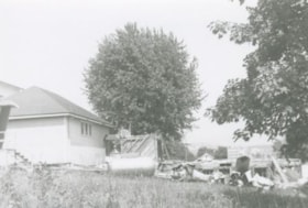
Extension of McPherson Park School
https://search.heritageburnaby.ca/link/archivedescription36489
- Repository
- City of Burnaby Archives
- Date
- September 1959
- Collection/Fonds
- Burnaby Historical Society fonds
- Description Level
- Item
- Physical Description
- 1 photograph : b&w ; 8.5 x 12.5 cm print
- Scope and Content
- Photograph of the A.J. Keel house with excavation for the extension of the McPherson Park School.
- Repository
- City of Burnaby Archives
- Date
- September 1959
- Collection/Fonds
- Burnaby Historical Society fonds
- Subseries
- Keel family subseries
- Physical Description
- 1 photograph : b&w ; 8.5 x 12.5 cm print
- Description Level
- Item
- Record No.
- 279-002
- Access Restriction
- No restrictions
- Reproduction Restriction
- Reproduce for fair dealing purposes only
- Accession Number
- BHS1992-09
- Scope and Content
- Photograph of the A.J. Keel house with excavation for the extension of the McPherson Park School.
- Names
- McPherson Park School
- Media Type
- Photograph
- Notes
- Title based on contents of photograph
- Geographic Access
- Rumble Street
- Historic Neighbourhood
- Alta-Vista (Historic Neighbourhood)
- Planning Study Area
- Clinton-Glenwood Area
Images


Extension of McPherson Park School
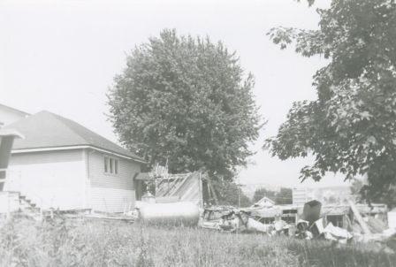
https://search.heritageburnaby.ca/link/archivedescription36490
- Repository
- City of Burnaby Archives
- Date
- September 1959
- Collection/Fonds
- Burnaby Historical Society fonds
- Description Level
- Item
- Physical Description
- 1 photograph : b&w ; 8.5 x 12.5 cm print
- Scope and Content
- Photograph of the A.J. Keel house with a close-up of the excavation for the extension of McPherson Park School.
- Repository
- City of Burnaby Archives
- Date
- September 1959
- Collection/Fonds
- Burnaby Historical Society fonds
- Subseries
- Keel family subseries
- Physical Description
- 1 photograph : b&w ; 8.5 x 12.5 cm print
- Description Level
- Item
- Record No.
- 279-003
- Access Restriction
- No restrictions
- Reproduction Restriction
- Reproduce for fair dealing purposes only
- Accession Number
- BHS1992-09
- Scope and Content
- Photograph of the A.J. Keel house with a close-up of the excavation for the extension of McPherson Park School.
- Names
- McPherson Park School
- Media Type
- Photograph
- Notes
- Title based on contents of photograph
- Geographic Access
- Rumble Street
- Historic Neighbourhood
- Alta-Vista (Historic Neighbourhood)
- Planning Study Area
- Clinton-Glenwood Area
Images

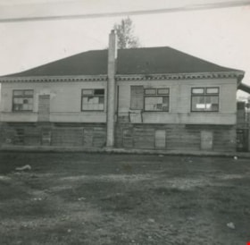
Old Bonsor Hall
https://search.heritageburnaby.ca/link/archivedescription37281
- Repository
- City of Burnaby Archives
- Date
- 1958
- Collection/Fonds
- Burnaby Historical Society fonds
- Description Level
- Item
- Physical Description
- 1 photograph : b&w ; 9 x 9 cm
- Scope and Content
- Photograph of the old Kingsway West school building which also served as the Bonsor Hall.
- Repository
- City of Burnaby Archives
- Date
- 1958
- Collection/Fonds
- Burnaby Historical Society fonds
- Subseries
- Norah Code subseries
- Physical Description
- 1 photograph : b&w ; 9 x 9 cm
- Description Level
- Item
- Record No.
- 345-002
- Access Restriction
- No restrictions
- Reproduction Restriction
- Reproduce for fair dealing purposes only
- Accession Number
- BHS1997-05
- Scope and Content
- Photograph of the old Kingsway West school building which also served as the Bonsor Hall.
- Media Type
- Photograph
- Photographer
- Code, Norah
- Notes
- Title based on contents of photograph
- Photographs in this collection were taken and compiled by Norah Code, former editor of the "Burnaby Courier" newspaper during the course of her work for the newspaper.
- Geographic Access
- Kingsway
- Street Address
- 4800 Kingsway
- Historic Neighbourhood
- Central Park (Historic Neighbourhood)
- Planning Study Area
- Maywood Area
Images

![School room at Oakalla, [195-] (date of original), copied 1991 thumbnail](/media/hpo/_Data/_Archives_Images/_Unrestricted/370/370-733.jpg?width=280)
School room at Oakalla
https://search.heritageburnaby.ca/link/archivedescription38146
- Repository
- City of Burnaby Archives
- Date
- [195-] (date of original), copied 1991
- Collection/Fonds
- Burnaby Historical Society fonds
- Description Level
- Item
- Physical Description
- 1 photograph : b&w ; 3.6 x 4.4 cm print on contact sheet 20.6 x 26.8 cm
- Scope and Content
- Photograph of the interior of a school room at Oakalla Prison Farm. Men are seated at desks, and a student and teacher are at the blackboard standing beside a map. A list of words is on the blackboard.
- Repository
- City of Burnaby Archives
- Date
- [195-] (date of original), copied 1991
- Collection/Fonds
- Burnaby Historical Society fonds
- Subseries
- Burnaby Image Bank subseries
- Physical Description
- 1 photograph : b&w ; 3.6 x 4.4 cm print on contact sheet 20.6 x 26.8 cm
- Description Level
- Item
- Record No.
- 370-733
- Access Restriction
- No restrictions
- Reproduction Restriction
- Reproduce for fair dealing purposes only
- Accession Number
- BHS1999-03
- Scope and Content
- Photograph of the interior of a school room at Oakalla Prison Farm. Men are seated at desks, and a student and teacher are at the blackboard standing beside a map. A list of words is on the blackboard.
- Subjects
- Documentary Artifacts - Maps
- Buildings - Public - Detention Facilities
- Buildings - Schools
- Occupations - Teachers
- Names
- Oakalla Prison Farm
- Media Type
- Photograph
- Notes
- Title based on contents of photograph
- 1 b&w copy negative accompanying
- Negative has a pink cast
- Geographic Access
- Oakmount Crescent
- Street Address
- 5220 Oakmount Crescent
- Historic Neighbourhood
- Burnaby Lake (Historic Neighbourhood)
- Planning Study Area
- Oakalla Area
Images
![School room at Oakalla, [195-] (date of original), copied 1991 thumbnail](/media/hpo/_Data/_Archives_Images/_Unrestricted/370/370-733.jpg)
![Alpha Secondary School, [1950 or 1951] thumbnail](/media/hpo/_Data/_Archives_Images/_Unrestricted/370/370-813.jpg?width=280)
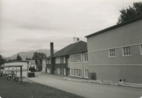
Alpha Secondary School
https://search.heritageburnaby.ca/link/archivedescription62709
- Repository
- City of Burnaby Archives
- Date
- [1950 or 1951]
- Collection/Fonds
- Burnaby Historical Society fonds
- Description Level
- Item
- Physical Description
- 1 photograph : b&w negative ; 5.5 x 7.5 cm
- Scope and Content
- Aerial photograph of Alpha Secondary School.
- Repository
- City of Burnaby Archives
- Date
- [1950 or 1951]
- Collection/Fonds
- Burnaby Historical Society fonds
- Subseries
- Burnaby Image Bank subseries
- Physical Description
- 1 photograph : b&w negative ; 5.5 x 7.5 cm
- Description Level
- Item
- Record No.
- 370-813
- Access Restriction
- No restrictions
- Reproduction Restriction
- Reproduce for fair dealing purposes only
- Accession Number
- BHS1999-03
- Scope and Content
- Aerial photograph of Alpha Secondary School.
- Subjects
- Aerial Photographs
- Buildings - Schools
- Names
- Alpha Secondary School
- Media Type
- Photograph
- Photographer
- Pride, A.H. "Harry"
- Notes
- Title based on contents of photograph
- 1 b&w original photograph accompanying
- Geographic Access
- Parker Street
- Street Address
- 4600 Parker Street
- Planning Study Area
- Brentwood Area
Images
![Alpha Secondary School, [1950 or 1951] thumbnail](/media/hpo/_Data/_Archives_Images/_Unrestricted/370/370-813.jpg)
Barnet School class
https://search.heritageburnaby.ca/link/museumdescription15225
- Repository
- Burnaby Village Museum
- Date
- 1937 (date of original), copied 2004
- Collection/Fonds
- In the Shadow by the Sea collection
- Description Level
- Item
- Physical Description
- 1 photograph (tiff) : 300 dpi
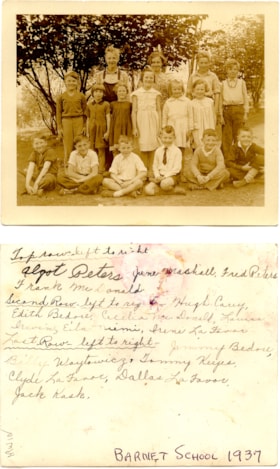
- Scope and Content
- Photograph students at Barnet School. Students are gathered together on the school grounds and are identified from left to right; back row: Algot Peters, June Marshall, Fred Peters and Frank McDonald; middle row: Hugh Carey, Edith Bedore, Cecilia McDonald, Louise Irwin, Ella Neimi, Irene La Favor;…
- Repository
- Burnaby Village Museum
- Collection/Fonds
- In the Shadow by the Sea collection
- Description Level
- Item
- Physical Description
- 1 photograph (tiff) : 300 dpi
- Scope and Content
- Photograph students at Barnet School. Students are gathered together on the school grounds and are identified from left to right; back row: Algot Peters, June Marshall, Fred Peters and Frank McDonald; middle row: Hugh Carey, Edith Bedore, Cecilia McDonald, Louise Irwin, Ella Neimi, Irene La Favor; front row: Jimmy Bedore, Billy Woytowicz, Tommy Keys, Clyde La Favor, Dallas La Favor and Jack Kask.
- Names
- Barnet School
- Peters, Algot
- Marshall, June
- Peters, Fred
- McDonald, Frank
- Carey, Hugh
- Bedore, Edith
- McDonald, Cecilia
- Irwin, Louise
- Neimi, Ella
- La Favor, Louise
- Bedore, Jimmy
- Woytowicz, Billy
- Keys, Thomas "Tommy"
- La Favor, Clyde
- La Favor, Dallas
- Kask, John "Jack"
- Geographic Access
- Burrard Inlet
- Accession Code
- BV019.32.45
- Access Restriction
- No restrictions
- Reproduction Restriction
- No known restrictions
- Date
- 1937 (date of original), copied 2004
- Media Type
- Photograph
- Historic Neighbourhood
- Barnet (Historic Neighbourhood)
- Planning Study Area
- Burnaby Mountain Area
- Notes
- Title based on contents of photograph
- Names of students taken from verso of photograph
- see page 234, Chapter Three in the book "In the Shadow by the Sea - Recollections of Burnaby's Barnet Village". Caption with photograph reads: "Barnet School / Class 1936-1937 / BACK ROW: Algot Peters, June / Marshall, Fred Peters: Frank / McDonald"
Images
![Barnet School class, [between 1931 and 1932] (date of original), copied 2004 thumbnail](/media/hpo/_Data/_BVM_Images/2019/2019_0032_0048_001.jpg?width=280)
Barnet School class
https://search.heritageburnaby.ca/link/museumdescription15228
- Repository
- Burnaby Village Museum
- Date
- [between 1931 and 1932] (date of original), copied 2004
- Collection/Fonds
- In the Shadow by the Sea collection
- Description Level
- Item
- Physical Description
- 1 photograph (tiff) : 300 dpi
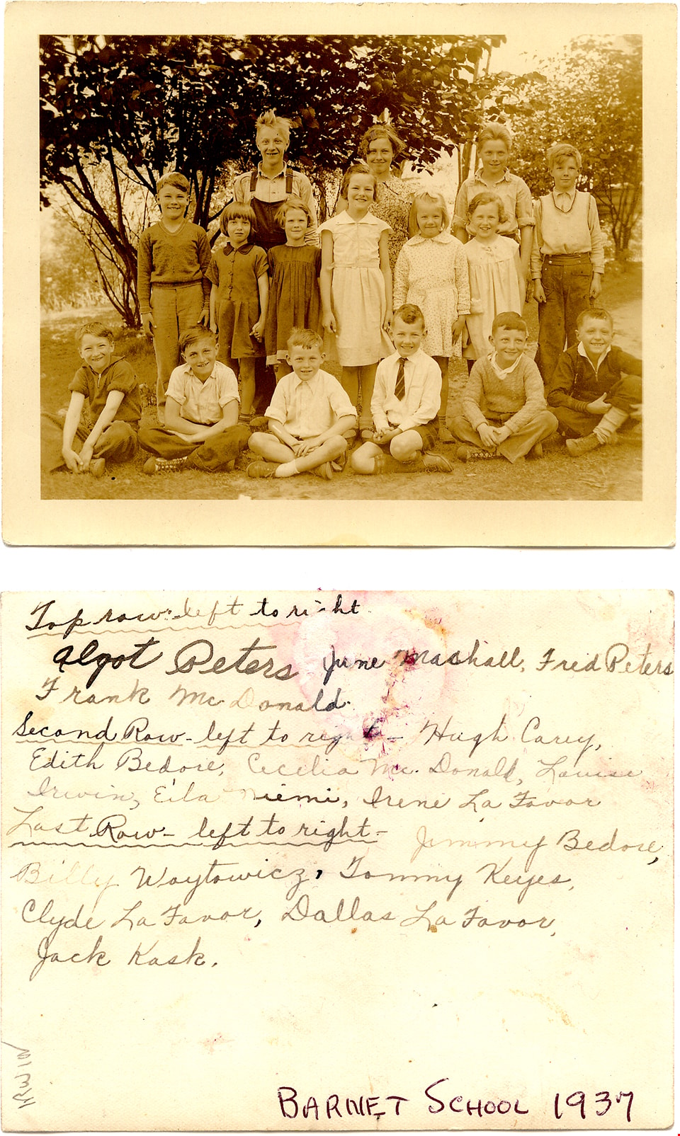
- Scope and Content
- Photograph students at Barnet School. Students are gathered together on wooden bleechers on the school grounds and are identified from left to right; back row: Jack Hood; Fred Proteau, Bob Johnston, John Stelioff, Billy Warner and Neil Carey; third row from bottom: Lloyd Lendgren, Joan Rutherford,…
- Repository
- Burnaby Village Museum
- Collection/Fonds
- In the Shadow by the Sea collection
- Description Level
- Item
- Physical Description
- 1 photograph (tiff) : 300 dpi
- Scope and Content
- Photograph students at Barnet School. Students are gathered together on wooden bleechers on the school grounds and are identified from left to right; back row: Jack Hood; Fred Proteau, Bob Johnston, John Stelioff, Billy Warner and Neil Carey; third row from bottom: Lloyd Lendgren, Joan Rutherford, Kathleen Cole, Patricia Longley, Annie Strelioff, Marie Galbraith and Billy Rutherford; second row from bottom: Jean Wallace, Eva Grace Hood, Kerthq's cousin, Kerthq, Maureen Johnston, Marie Swanson, Eleanor Irwin; front row at bottom: John Taranoff, John Jacobsen, Lewis La Favor, Jack Rutherford, Andrew Strelioff and Sheldon Rowell.
- Names
- Barnet School
- Yasui, Harding
- Hood, Jack
- Proteau, Frederick "Freddy"
- Stride Avenue School
- Johnston, Bob
- Strelioff, John
- Strelioff, Annie
- Warner, William "Billy"
- Carey, Neil
- Lendgren, Lloyd
- Rutherford, Joan
- Cole, Kathleen
- Longley, Patricia
- Galbraith, Marie
- Rutherford, William "Billy"
- Wallace, Jean
- Hood, Grace
- Kerthq
- Johnston, Maureen
- Swanson, Marie
- Nelson, Eleanor Irwin
- Taranoff, John
- Jacobsen, John
- La Favor, Lewis
- Rutherford, Jack S.
- Strelioff, Andrew
- Sheldon, Rowell
- Geographic Access
- Burrard Inlet
- Accession Code
- BV019.32.48
- Access Restriction
- No restrictions
- Reproduction Restriction
- No known restrictions
- Date
- [between 1931 and 1932] (date of original), copied 2004
- Media Type
- Photograph
- Historic Neighbourhood
- Barnet (Historic Neighbourhood)
- Planning Study Area
- Burnaby Mountain Area
- Notes
- Title based on contents of photograph
- Names of students taken from verso of photograph -see photograph BV019.32.47
- see page 234, Chapter Three in the book "In the Shadow by the Sea - Recollections of Burnaby's Barnet Village". Caption with photograph reads: "Barnet School / Class 1931-1932 / BACK ROW: Harding Yasui, Jack Hood, Fred Proteau, Bob Johnston, John Strelioff, Billy Warner, Neil Carey / THIRD ROW: ..."
Images
![Barnet School class, [between 1931 and 1932] (date of original), copied 2004 thumbnail](/media/hpo/_Data/_BVM_Images/2019/2019_0032_0048_001.jpg)

Burnaby North High School grade 9 class
https://search.heritageburnaby.ca/link/museumdescription13691
- Repository
- Burnaby Village Museum
- Date
- 1931
- Collection/Fonds
- Westerman family fonds
- Description Level
- Item
- Physical Description
- 1 photograph : sepia ; 12.5 x 17.5 cm
- Scope and Content
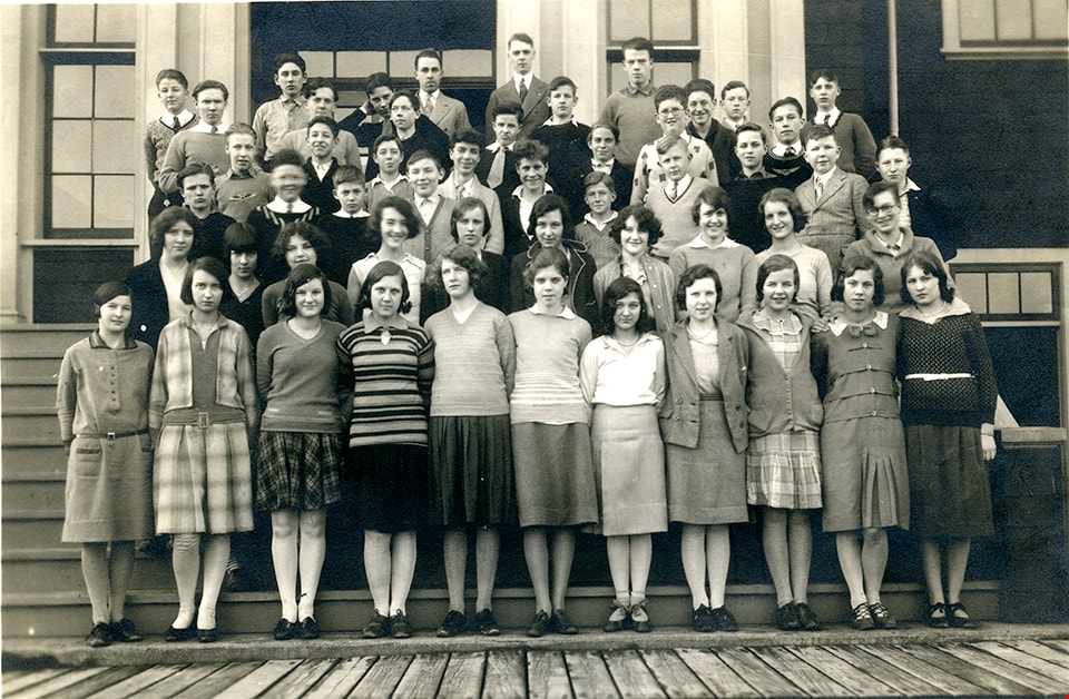
- Photograph of the grade nine class of Burnaby North High School arranged in rows and standing in front of the entrance to the school. Walter "Wally" Westerman is identified on the far left, standing in the fourth row from the bottom.
- Repository
- Burnaby Village Museum
- Collection/Fonds
- Westerman family fonds
- Description Level
- Item
- Physical Description
- 1 photograph : sepia ; 12.5 x 17.5 cm
- Material Details
- `
- Scope and Content
- Photograph of the grade nine class of Burnaby North High School arranged in rows and standing in front of the entrance to the school. Walter "Wally" Westerman is identified on the far left, standing in the fourth row from the bottom.
- Subjects
- Persons - Students
- Buildings - Schools
- Geographic Access
- Pandora Street
- Street Address
- 4375 Pandora Street
- Accession Code
- BV020.17.15
- Access Restriction
- No restrictions
- Reproduction Restriction
- No known restrictions
- Date
- 1931
- Media Type
- Photograph
- Historic Neighbourhood
- Vancouver Heights (Historic Neighbourhood)
- Planning Study Area
- Burnaby Heights Area
- Scan Resolution
- 600
- Scan Date
- 22-Sep-2020
- Scale
- 100
- Notes
- Title based on contents of photograph
- Handwritten note in pencil on verso of photograph reads: "Walter age 14/1931 1st year high"
Images
![Children finger painting in a classroom, [between 1957 and 1968] thumbnail](/media/hpo/_Data/_Archives_Images/_Unrestricted/205/246-005.jpg?width=280)
Children finger painting in a classroom
https://search.heritageburnaby.ca/link/archivedescription52965
- Repository
- City of Burnaby Archives
- Date
- [between 1957 and 1968]
- Collection/Fonds
- Burnaby Historical Society fonds
- Description Level
- Item
- Physical Description
- 1 photograph : b&w ; 7.5 x 7.5 cm
- Scope and Content
- Photograph of kindergartners finger panting in a classroom at the Tinkerbell Cooperative Kindergarten. One child is climbing on a chair to reach a high cupboard and others are busy working on their finger paintings.
- Repository
- City of Burnaby Archives
- Date
- [between 1957 and 1968]
- Collection/Fonds
- Burnaby Historical Society fonds
- Subseries
- Tinkerbell Kindergarten subseries
- Physical Description
- 1 photograph : b&w ; 7.5 x 7.5 cm
- Description Level
- Item
- Record No.
- 246-005
- Access Restriction
- No restrictions
- Reproduction Restriction
- Reproduce for fair dealing purposes only
- Accession Number
- BHS1990-12
- Scope and Content
- Photograph of kindergartners finger panting in a classroom at the Tinkerbell Cooperative Kindergarten. One child is climbing on a chair to reach a high cupboard and others are busy working on their finger paintings.
- Subjects
- Buildings - Schools
- Arts - Paintings
- Media Type
- Photograph
- Notes
- Title based on contents of photograph
- Geographic Access
- Ellesmere Avenue
- Hastings Street
- Street Address
- 300 Ellesmere Avenue North
- Historic Neighbourhood
- Capitol Hill (Historic Neighbourhood)
- Planning Study Area
- Capitol Hill Area
Images
![Children finger painting in a classroom, [between 1957 and 1968] thumbnail](/media/hpo/_Data/_Archives_Images/_Unrestricted/205/246-005.jpg)
![Children playing in a classroom, [between 1957 and 1968] thumbnail](/media/hpo/_Data/_Archives_Images/_Unrestricted/205/246-006.jpg?width=280)
Children playing in a classroom
https://search.heritageburnaby.ca/link/archivedescription52966
- Repository
- City of Burnaby Archives
- Date
- [between 1957 and 1968]
- Collection/Fonds
- Burnaby Historical Society fonds
- Description Level
- Item
- Physical Description
- 1 photograph : col. ; 7.5 x 7.5 cm
- Scope and Content
- Photograph of a classroom full of kindergartners all making paper hats with the help of their teacher at the Tinkerbell Cooperative Kindergarten.
- Repository
- City of Burnaby Archives
- Date
- [between 1957 and 1968]
- Collection/Fonds
- Burnaby Historical Society fonds
- Subseries
- Tinkerbell Kindergarten subseries
- Physical Description
- 1 photograph : col. ; 7.5 x 7.5 cm
- Description Level
- Item
- Record No.
- 246-006
- Access Restriction
- No restrictions
- Reproduction Restriction
- Reproduce for fair dealing purposes only
- Accession Number
- BHS1990-12
- Scope and Content
- Photograph of a classroom full of kindergartners all making paper hats with the help of their teacher at the Tinkerbell Cooperative Kindergarten.
- Media Type
- Photograph
- Notes
- Title based on contents of photograph
- Geographic Access
- Ellesmere Avenue
- Hastings Street
- Street Address
- 300 Ellesmere Avenue North
- Historic Neighbourhood
- Capitol Hill (Historic Neighbourhood)
- Planning Study Area
- Capitol Hill Area
Images
![Children playing in a classroom, [between 1957 and 1968] thumbnail](/media/hpo/_Data/_Archives_Images/_Unrestricted/205/246-006.jpg)
Demolition debris at Douglas Road School
https://search.heritageburnaby.ca/link/archivedescription38645
- Repository
- City of Burnaby Archives
- Date
- 1956
- Collection/Fonds
- Burnaby Historical Society fonds
- Description Level
- Item
- Physical Description
- 1 photograph : b&w ; 10 x 15 cm
- Scope and Content
- Photograph of demolition debris outside the Douglas Road School.
- Repository
- City of Burnaby Archives
- Date
- 1956
- Collection/Fonds
- Burnaby Historical Society fonds
- Subseries
- Douglas Road School subseries
- Physical Description
- 1 photograph : b&w ; 10 x 15 cm
- Description Level
- Item
- Record No.
- 471-006
- Access Restriction
- No restrictions
- Reproduction Restriction
- Reproduce for fair dealing purposes only
- Accession Number
- BHS2005-3
- Scope and Content
- Photograph of demolition debris outside the Douglas Road School.
- Subjects
- Buildings - Schools
- Construction
- Names
- Douglas Road School
- Media Type
- Photograph
- Photographer
- Gordon, Ethel
- Notes
- Title based on contents of photograph
- Geographic Access
- Canada Way
- Street Address
- 4861 Canada Way
- Historic Neighbourhood
- Burnaby Lake (Historic Neighbourhood)
- Planning Study Area
- Douglas-Gilpin Area
Images
Douglas Road School
https://search.heritageburnaby.ca/link/archivedescription38640
- Repository
- City of Burnaby Archives
- Date
- 1956
- Collection/Fonds
- Burnaby Historical Society fonds
- Description Level
- Item
- Physical Description
- 1 photograph : b&w ; 8.5 x 12.5 cm
- Scope and Content
- Photograph of the back of Douglas Road School. Unidentified children are playing near the tire swings and near the school.
- Repository
- City of Burnaby Archives
- Date
- 1956
- Collection/Fonds
- Burnaby Historical Society fonds
- Subseries
- Douglas Road School subseries
- Physical Description
- 1 photograph : b&w ; 8.5 x 12.5 cm
- Description Level
- Item
- Record No.
- 471-001
- Access Restriction
- No restrictions
- Reproduction Restriction
- Reproduce for fair dealing purposes only
- Accession Number
- BHS2005-3
- Scope and Content
- Photograph of the back of Douglas Road School. Unidentified children are playing near the tire swings and near the school.
- Subjects
- Buildings - Schools
- Names
- Douglas Road School
- Media Type
- Photograph
- Photographer
- Gordon, Ethel
- Notes
- Title based on contents of photograph.
- Geographic Access
- Canada Way
- Street Address
- 4861 Canada Way
- Historic Neighbourhood
- Burnaby Lake (Historic Neighbourhood)
- Planning Study Area
- Douglas-Gilpin Area
Images

Douglas Road School
https://search.heritageburnaby.ca/link/archivedescription38642
- Repository
- City of Burnaby Archives
- Date
- 1956
- Collection/Fonds
- Burnaby Historical Society fonds
- Description Level
- Item
- Physical Description
- 1 photograph : b&w ; 10 x 10 cm
- Scope and Content
- Photograph of the partially demolished building at the Douglas Road School site.
- Repository
- City of Burnaby Archives
- Date
- 1956
- Collection/Fonds
- Burnaby Historical Society fonds
- Subseries
- Douglas Road School subseries
- Physical Description
- 1 photograph : b&w ; 10 x 10 cm
- Description Level
- Item
- Record No.
- 471-003
- Access Restriction
- No restrictions
- Reproduction Restriction
- Reproduce for fair dealing purposes only
- Accession Number
- BHS2005-3
- Scope and Content
- Photograph of the partially demolished building at the Douglas Road School site.
- Subjects
- Buildings - Schools
- Construction
- Names
- Douglas Road School
- Media Type
- Photograph
- Photographer
- Gordon, Ethel
- Notes
- Title based on contents of photograph.
- Geographic Access
- Canada Way
- Street Address
- 4861 Canada Way
- Historic Neighbourhood
- Burnaby Lake (Historic Neighbourhood)
- Planning Study Area
- Douglas-Gilpin Area
Images


Douglas Road School renovation
https://search.heritageburnaby.ca/link/archivedescription38647
- Repository
- City of Burnaby Archives
- Date
- 1956
- Collection/Fonds
- Burnaby Historical Society fonds
- Description Level
- Item
- Physical Description
- 1 photograph : b&w ; 10 x 15 cm
- Scope and Content
- Photograph of a the Douglas Road school under renovations.
- Repository
- City of Burnaby Archives
- Date
- 1956
- Collection/Fonds
- Burnaby Historical Society fonds
- Subseries
- Douglas Road School subseries
- Physical Description
- 1 photograph : b&w ; 10 x 15 cm
- Description Level
- Item
- Record No.
- 471-008
- Access Restriction
- No restrictions
- Reproduction Restriction
- Reproduce for fair dealing purposes only
- Accession Number
- BHS2005-3
- Scope and Content
- Photograph of a the Douglas Road school under renovations.
- Subjects
- Construction
- Buildings - Schools
- Names
- Douglas Road School
- Media Type
- Photograph
- Photographer
- Gordon, Ethel
- Notes
- Title based on contents of photograph
- Geographic Access
- Canada Way
- Street Address
- 4861 Canada Way
- Historic Neighbourhood
- Burnaby Lake (Historic Neighbourhood)
- Planning Study Area
- Douglas-Gilpin Area
Images

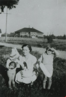
Dunn family
https://search.heritageburnaby.ca/link/archivedescription37683
- Repository
- City of Burnaby Archives
- Date
- October 1937 (date of original), copied 1991
- Collection/Fonds
- Burnaby Historical Society fonds
- Description Level
- Item
- Physical Description
- 1 photograph : b&w ; 4.1 x 2.8 cm print on contact sheet 20.2 x 25.3 cm
- Scope and Content
- Photograph of Ilma Dunn (centre) and her sons, Robert Dunn (left) and Fred Dunn (right), with 2nd Street School in the background. They each have toys in their hands. Robert is wearing a mask pushed to the top of his head.
- Repository
- City of Burnaby Archives
- Date
- October 1937 (date of original), copied 1991
- Collection/Fonds
- Burnaby Historical Society fonds
- Subseries
- Burnaby Image Bank subseries
- Physical Description
- 1 photograph : b&w ; 4.1 x 2.8 cm print on contact sheet 20.2 x 25.3 cm
- Description Level
- Item
- Record No.
- 370-271
- Access Restriction
- No restrictions
- Reproduction Restriction
- No known restrictions
- Accession Number
- BHS1999-03
- Scope and Content
- Photograph of Ilma Dunn (centre) and her sons, Robert Dunn (left) and Fred Dunn (right), with 2nd Street School in the background. They each have toys in their hands. Robert is wearing a mask pushed to the top of his head.
- Subjects
- Buildings - Schools
- Toys
- Media Type
- Photograph
- Notes
- Title based on contents of photograph
- 1 b&w copy negative accompanying
- Negative has a pink cast
- Geographic Access
- 2nd Street
- Street Address
- 7502 2nd Street
- Historic Neighbourhood
- East Burnaby (Historic Neighbourhood)
- Planning Study Area
- Second Street Area
Images

![Edmonds School trustees with architect and inspector, [between 1952 and 1956] thumbnail](/media/hpo/_Data/_Archives_Images/_Unrestricted/251/302-001.jpg?width=280)
Edmonds School trustees with architect and inspector
https://search.heritageburnaby.ca/link/archivedescription36578
- Repository
- City of Burnaby Archives
- Date
- [between 1952 and 1956]
- Collection/Fonds
- Burnaby Historical Society fonds
- Description Level
- Item
- Physical Description
- 1 photograph : sepia ; 19.5 x 24 cm
- Scope and Content
- Photograph of six men consulting blueprints outside in the snow at the site of the Edmonds Street School addition under construction. Standing in a row are;Trustee W. Maxwell, Architect Davies, Inspector Fredrickson, School Board Secretary Durkin, Trustee Samuel Norman Noble, and Principal Davis.
- Repository
- City of Burnaby Archives
- Date
- [between 1952 and 1956]
- Collection/Fonds
- Burnaby Historical Society fonds
- Subseries
- Photographs subseries
- Physical Description
- 1 photograph : sepia ; 19.5 x 24 cm
- Description Level
- Item
- Record No.
- 302-001
- Access Restriction
- No restrictions
- Reproduction Restriction
- Reproduce for fair dealing purposes only
- Accession Number
- BHS1992-43
- Scope and Content
- Photograph of six men consulting blueprints outside in the snow at the site of the Edmonds Street School addition under construction. Standing in a row are;Trustee W. Maxwell, Architect Davies, Inspector Fredrickson, School Board Secretary Durkin, Trustee Samuel Norman Noble, and Principal Davis.
- Subjects
- Buildings - Schools
- Construction
- Media Type
- Photograph
- Notes
- Title based on contents of photograph
- Handwritten note on verso of photograph identifies the individuals in the photograph and comments on them
- Copyright note: Images provided on this website are intended for research purposes only. Further use of any image is subject to the terms of the Copyright Act of Canada.
- Geographic Access
- 18th Avenue
- Street Address
- 7651 18th Avenue
- Historic Neighbourhood
- Edmonds (Historic Neighbourhood)
- Planning Study Area
- Edmonds Area
Images
![Edmonds School trustees with architect and inspector, [between 1952 and 1956] thumbnail](/media/hpo/_Data/_Archives_Images/_Unrestricted/251/302-001.jpg)