Narrow Results By
Subject
- Aerial Photographs 1
- Buildings - Civic - Fire Halls 2
- Buildings - Commercial - Stores 1
- Clothing - Uniforms 1
- Construction 1
- Geographic Features - Sidewalks 1
- Land Clearing 1
- Occupations - Clergy 1
- Occupations - Clerks 1
- Occupations - Fire Fighters 1
- Transportation - Horses 1
- Transportation - Wagons 1
![Aerial photograph of Douglas Road and Sperling Avenue, [1938] thumbnail](/media/hpo/_Data/_BVM_Images/1990/199200470001.jpg?width=280)
Aerial photograph of Douglas Road and Sperling Avenue
https://search.heritageburnaby.ca/link/museumdescription1165
- Repository
- Burnaby Village Museum
- Date
- [1938]
- Collection/Fonds
- Burnaby Village Museum Photograph collection
- Description Level
- Item
- Physical Description
- 1 photograph : b&w ; 19 x 24 cm
- Scope and Content
- Aerial photograph of the area surrounding Douglas Road and Sperling Avenue.
- Repository
- Burnaby Village Museum
- Collection/Fonds
- Burnaby Village Museum Photograph collection
- Description Level
- Item
- Physical Description
- 1 photograph : b&w ; 19 x 24 cm
- Scope and Content
- Aerial photograph of the area surrounding Douglas Road and Sperling Avenue.
- Subjects
- Aerial Photographs
- Geographic Access
- Douglas Road
- Sperling Avenue
- Accession Code
- BV992.47.1
- Access Restriction
- No restrictions
- Date
- [1938]
- Media Type
- Photograph
- Historic Neighbourhood
- Burnaby Lake (Historic Neighbourhood)
- Planning Study Area
- Morley-Buckingham Area
- Scan Resolution
- 600
- Scan Date
- 01-Jun-09
- Scale
- 100
- Notes
- Title based on contents of photograph
- Notes on verso of photograph read: "Burnaby Image Bank #532" and "DOUGLAS ROAD AND SPERLING c. 1938"
- Stamp on verso of photograph reads: "Copyright Simon Fraser/ University Archives"
Images
![Aerial photograph of Douglas Road and Sperling Avenue, [1938] thumbnail](/media/hpo/_Data/_BVM_Images/1990/199200470001.jpg)
![Common Good Co-op Store, [1938] thumbnail](/media/hpo/_Data/_BVM_Images/1976/1976_0046_0001_001.jpg?width=280)
Common Good Co-op Store
https://search.heritageburnaby.ca/link/museumdescription735
- Repository
- Burnaby Village Museum
- Date
- [1938]
- Collection/Fonds
- Burnaby Village Museum Photograph collection
- Description Level
- Item
- Physical Description
- 1 photograph : sepia ; 6.8 x 11.2 cm
- Scope and Content
- Photograph of a man in an apron standing in front of a co-op store bearing the sign "C.G. Co-operative Association", otherwise known as the Army of the Common Good. Window displays include the goods he carries and advertising signs for Coca-Cola and Orange Crush are put up below the windows. In fro…
- Repository
- Burnaby Village Museum
- Collection/Fonds
- Burnaby Village Museum Photograph collection
- Description Level
- Item
- Physical Description
- 1 photograph : sepia ; 6.8 x 11.2 cm
- Material Details
- Inscribed in pencil, recto, b. "Co op store Douglas R." and in blue ink, verso, t. "Coop Store Douglas Road/ C.G. Co-op 1939", b. "Mr Love Mayor of/ store/ no 2", in blue ball point pen, l.l. "Main Store was at McKay station/ this is No 1 Branch store" stamped on verso, c. "VANCOUVER/ DRUG CO. LTD/ SEP 12 1938/ Nu-Gloss"
- Scope and Content
- Photograph of a man in an apron standing in front of a co-op store bearing the sign "C.G. Co-operative Association", otherwise known as the Army of the Common Good. Window displays include the goods he carries and advertising signs for Coca-Cola and Orange Crush are put up below the windows. In front of the store is wood plank sidewalk.
- Geographic Access
- Douglas Road
- Accession Code
- HV976.46.1
- Access Restriction
- No restrictions
- Reproduction Restriction
- No known restrictions
- Date
- [1938]
- Media Type
- Photograph
- Scan Resolution
- 600
- Scan Date
- 2023-06-20
- Notes
- Title based on caption of photograph
Images
![Common Good Co-op Store, [1938] thumbnail](/media/hpo/_Data/_BVM_Images/1976/1976_0046_0001_001.jpg)

Construction of Saint Theresa's Roman Catholic Church
https://search.heritageburnaby.ca/link/museumdescription903
- Repository
- Burnaby Village Museum
- Date
- March 19, 1929
- Collection/Fonds
- Burnaby Village Museum Photograph collection
- Description Level
- Item
- Physical Description
- 1 photograph : sepia ; 6.9 x 11.5 cm
- Scope and Content
- Photograph of Douglas Road (later renamed in part Canada Way) with Laurel Street in the background on the left and the site of Saint Theresa's Roman Catholic Church as a lot with blackened stumps. The church was located at the southeast corner of Canada Way and Laurel Street. The photograph is ta…
- Repository
- Burnaby Village Museum
- Collection/Fonds
- Burnaby Village Museum Photograph collection
- Description Level
- Item
- Physical Description
- 1 photograph : sepia ; 6.9 x 11.5 cm
- Scope and Content
- Photograph of Douglas Road (later renamed in part Canada Way) with Laurel Street in the background on the left and the site of Saint Theresa's Roman Catholic Church as a lot with blackened stumps. The church was located at the southeast corner of Canada Way and Laurel Street. The photograph is taken from the same angle as HV975.105.1. There is a freight wagon loaded with lumber, pulled by two horses on Douglas Road. An annotation on the back of the photo reads, "March 19th 1929 / The first load of lumber taken for the construction of St St [sic] Therese [sic] Church on the Grandview Highway / Burnaby BC."
- Geographic Access
- Douglas Road
- Canada Way
- Laurel Street
- Accession Code
- HV975.105.2
- Access Restriction
- No restrictions
- Reproduction Restriction
- No known restrictions
- Date
- March 19, 1929
- Media Type
- Photograph
- Historic Neighbourhood
- Burnaby Lake (Historic Neighbourhood)
- Planning Study Area
- Douglas-Gilpin Area
- Scan Resolution
- 600
- Scan Date
- 2023-06-13
- Notes
- Title based on contents of photograph
- Information on the scope and content of the photograph is taken from an acquisition record from the time of the accession
Images

![Eight Clergymen at Saint Theresa's Roman Catholic Church, [192-] thumbnail](/media/hpo/_Data/_BVM_Images/1975/1975_0105_0003_001.jpg?width=280)
Eight Clergymen at Saint Theresa's Roman Catholic Church
https://search.heritageburnaby.ca/link/museumdescription904
- Repository
- Burnaby Village Museum
- Date
- [192-]
- Collection/Fonds
- Burnaby Village Museum Photograph collection
- Description Level
- Item
- Physical Description
- 1 photograph : b&w ; 5.7 x 8.2 cm
- Scope and Content
- Photograph of eight unidentified clergymen posed outside in front of a brick building. Four are standing and the other four are seated in front of the standing men. On the right side of the photo, there is a sign that reads, "In Your Prayers / Kindly Remember." The location has been identified as…
- Repository
- Burnaby Village Museum
- Collection/Fonds
- Burnaby Village Museum Photograph collection
- Description Level
- Item
- Physical Description
- 1 photograph : b&w ; 5.7 x 8.2 cm
- Scope and Content
- Photograph of eight unidentified clergymen posed outside in front of a brick building. Four are standing and the other four are seated in front of the standing men. On the right side of the photo, there is a sign that reads, "In Your Prayers / Kindly Remember." The location has been identified as Saint Theresa's Roman Catholic Church. The church was located at the southeast corner of Canada Way and Laurel Street. Built in 1929, it was torn down in 1974, and a new church, St.Theresa's Parish, was built across the street.
- Subjects
- Occupations - Clergy
- Geographic Access
- Douglas Road
- Canada Way
- Laurel Street
- Accession Code
- HV975.105.3
- Access Restriction
- No restrictions
- Reproduction Restriction
- May be restricted by third party rights
- Date
- [192-]
- Media Type
- Photograph
- Historic Neighbourhood
- Burnaby Lake (Historic Neighbourhood)
- Planning Study Area
- Douglas-Gilpin Area
- Scan Resolution
- 600
- Scan Date
- 2023-06-13
- Notes
- Title based on contents of photograph
Images
![Eight Clergymen at Saint Theresa's Roman Catholic Church, [192-] thumbnail](/media/hpo/_Data/_BVM_Images/1975/1975_0105_0003_001.jpg)

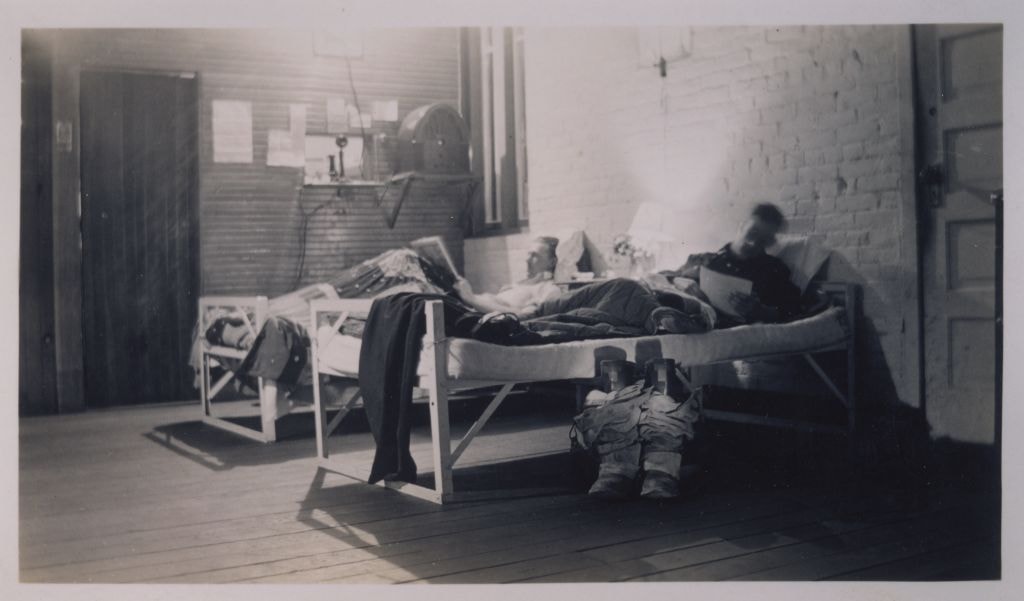
Firefighters Albert Killer and Fred Blake
https://search.heritageburnaby.ca/link/museumdescription1294
- Repository
- Burnaby Village Museum
- Date
- 1939 (date of original)
- Collection/Fonds
- Burnaby Village Museum Photograph collection
- Description Level
- Item
- Physical Description
- 1 photograph : b&w ; 8.5 x 15 cm print
- Scope and Content
- Photograph of Firefighters Albert Killer and Fred Blake lying down on their beds and reading (in the dormitory during the night shift) at No. 1 Burnaby Fire Hall at Carleton Avenue and Eton Street. Fire boots (with fire resistant pants gathered over them) are visible at the side of Fred Blake's bed.
- Repository
- Burnaby Village Museum
- Collection/Fonds
- Burnaby Village Museum Photograph collection
- Description Level
- Item
- Physical Description
- 1 photograph : b&w ; 8.5 x 15 cm print
- Material Details
- .
- Scope and Content
- Photograph of Firefighters Albert Killer and Fred Blake lying down on their beds and reading (in the dormitory during the night shift) at No. 1 Burnaby Fire Hall at Carleton Avenue and Eton Street. Fire boots (with fire resistant pants gathered over them) are visible at the side of Fred Blake's bed.
- Geographic Access
- Carleton Avenue
- Eton Street
- Accession Code
- BV998.31.3
- Access Restriction
- No restrictions
- Reproduction Restriction
- No known restrictions
- Date
- 1939 (date of original)
- Media Type
- Photograph
- Historic Neighbourhood
- Vancouver Heights (Historic Neighbourhood)
- Planning Study Area
- Burnaby Heights Area
- Scan Resolution
- 600
- Scan Date
- 02-Jun-09
- Scale
- 100
- Notes
- Title based on contents of photograph
- Typed sticker on verso of photograph reads: "Night shift at No.1 Hall/ Carleton Ave. and Eton St. (L) Albert Killer (R) Fred Blake 1939"
- Address sticker on verso of photograph reads: "MR & MRS F BLAKE 4165 PANDORA ST BURNABY BC V5C 2B2"
Images
![Fire hall no. 1, [1925] (date of original) thumbnail](/media/hpo/_Data/_BVM_Images/1990/199800310005.jpg?width=280)
Fire hall no. 1
https://search.heritageburnaby.ca/link/museumdescription1296
- Repository
- Burnaby Village Museum
- Date
- [1925] (date of original)
- Collection/Fonds
- Burnaby Village Museum Photograph collection
- Description Level
- Item
- Physical Description
- 1 photograph : b&w ; 10 x 15 cm print
- Scope and Content
- Photograph of North Burnaby's first fire hall (the building was originally used as a pump house before it was converted).
- Repository
- Burnaby Village Museum
- Collection/Fonds
- Burnaby Village Museum Photograph collection
- Description Level
- Item
- Physical Description
- 1 photograph : b&w ; 10 x 15 cm print
- Scope and Content
- Photograph of North Burnaby's first fire hall (the building was originally used as a pump house before it was converted).
- Subjects
- Buildings - Civic - Fire Halls
- Names
- Burnaby Fire Department
- Geographic Access
- Carleton Avenue
- Eton Street
- Accession Code
- BV998.31.5
- Access Restriction
- No restrictions
- Reproduction Restriction
- No known restrictions
- Date
- [1925] (date of original)
- Media Type
- Photograph
- Historic Neighbourhood
- Vancouver Heights (Historic Neighbourhood)
- Planning Study Area
- Burnaby Heights Area
- Scan Resolution
- 600
- Scan Date
- 01-Jun-09
- Scale
- 100
- Photographer
- Blake, Frederick "Fred"
- Notes
- Title based on contents of photograph
- Typed sticker on verso of photograph reads: "Burnaby's first fire hall Carleton Ave. and Eton St. 290 N (1925)"
- Address sticker on verso of photograph reads: "MR & MRS F BLAKE 4165 PANDORA ST BURNABY BC V5C 2B2"
Images
![Fire hall no. 1, [1925] (date of original) thumbnail](/media/hpo/_Data/_BVM_Images/1990/199800310005.jpg)

Land being cleared for Saint Theresa's Roman Catholic Church
https://search.heritageburnaby.ca/link/museumdescription902
- Repository
- Burnaby Village Museum
- Date
- 1929
- Collection/Fonds
- Burnaby Village Museum Photograph collection
- Description Level
- Item
- Physical Description
- 1 photograph : b&w ; 6.7 x 11.4 cm
- Scope and Content
- Photograph of three unidentified men standing on Douglas Road (later renamed in part Canada Way) with Laurel Street in the background on the left and the site of Saint Theresa's Roman Catholic Church as a lot with blackened stumps. The church was located at the southeast corner of Canada Way and L…
- Repository
- Burnaby Village Museum
- Collection/Fonds
- Burnaby Village Museum Photograph collection
- Description Level
- Item
- Physical Description
- 1 photograph : b&w ; 6.7 x 11.4 cm
- Scope and Content
- Photograph of three unidentified men standing on Douglas Road (later renamed in part Canada Way) with Laurel Street in the background on the left and the site of Saint Theresa's Roman Catholic Church as a lot with blackened stumps. The church was located at the southeast corner of Canada Way and Laurel Street. According to an accompanying note located with the photograph, the first church building burned to the ground the night before it was to be blessed. Insurance for the church had been arranged for by Colonel Dorrell only hours before it was burned and even though signatures had not been affixed to the policy, the insurance company honoured the claim. The second building was smaller and had no basement. Father Trainer was the first priest. This church was torn down in 1974 and a new church building was erected across the road on Canada Way.
- Subjects
- Land Clearing
- Geographic Access
- Douglas Road
- Canada Way
- Laurel Street
- Accession Code
- HV975.105.1
- Access Restriction
- No restrictions
- Reproduction Restriction
- No known restrictions
- Date
- 1929
- Media Type
- Photograph
- Historic Neighbourhood
- Burnaby Lake (Historic Neighbourhood)
- Planning Study Area
- Douglas-Gilpin Area
- Scan Resolution
- 600
- Scan Date
- 2023-06-06
- Notes
- Title based on contents of photograph
- Information on the scope and content of the photograph is taken from an acquisition record from the time of the accession
Images
