Preparation for wallpaper border
https://search.heritageburnaby.ca/link/museumdescription12114
- Repository
- Burnaby Village Museum
- Date
- 1998
- Collection/Fonds
- Burnaby Village Museum fonds
- Description Level
- Item
- Physical Description
- 1 photograph : col. ; 10 x 15 cm
- Scope and Content
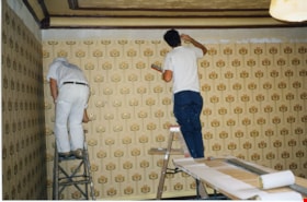
- Photograph of "Burnaby" wallpaper inside the parlour of the Jesse Love farmhouse. Top of wallpaper is being trimmed to prepare for the installation of the wallpaper border.
- Repository
- Burnaby Village Museum
- Collection/Fonds
- Burnaby Village Museum fonds
- Series
- Jesse Love farmhouse series
- Description Level
- Item
- Physical Description
- 1 photograph : col. ; 10 x 15 cm
- Scope and Content
- Photograph of "Burnaby" wallpaper inside the parlour of the Jesse Love farmhouse. Top of wallpaper is being trimmed to prepare for the installation of the wallpaper border.
- Names
- Burnaby Village Museum
- Accession Code
- BV018.41.933
- Access Restriction
- No restrictions
- Reproduction Restriction
- May be restricted by third party rights
- Date
- 1998
- Media Type
- Photograph
- Related Material
- See BV018.41.85 for File level description
- Scan Resolution
- 600
- Scan Date
- 04-Nov-19
- Photographer
- Langlet, Lisa
- Notes
- Title based on contents of photograph
- 1 col. photograph negative accompanying print; Part of Farmhouse restoration photographs -Book 3 - BV018.41.85
Images

Preparing linoleum
https://search.heritageburnaby.ca/link/museumdescription12125
- Repository
- Burnaby Village Museum
- Date
- 1998
- Collection/Fonds
- Burnaby Village Museum fonds
- Description Level
- Item
- Physical Description
- 1 photograph : col. ; 15 x 10 cm
- Scope and Content
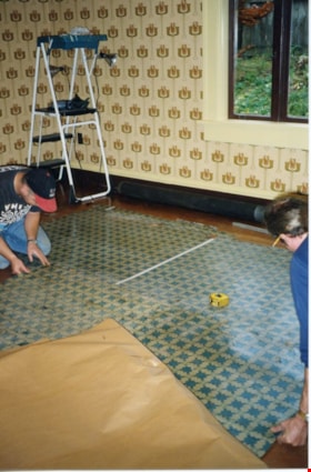
- Photograph of linoleum being prepared for installation in the front hallway of the Love farmhouse. Preparation is being done inside of the parlour.
- Repository
- Burnaby Village Museum
- Collection/Fonds
- Burnaby Village Museum fonds
- Series
- Jesse Love farmhouse series
- Description Level
- Item
- Physical Description
- 1 photograph : col. ; 15 x 10 cm
- Scope and Content
- Photograph of linoleum being prepared for installation in the front hallway of the Love farmhouse. Preparation is being done inside of the parlour.
- Names
- Burnaby Village Museum
- Accession Code
- BV018.41.944
- Access Restriction
- No restrictions
- Reproduction Restriction
- May be restricted by third party rights
- Date
- 1998
- Media Type
- Photograph
- Related Material
- See BV018.41.85 for File level description
- Scan Resolution
- 600
- Scan Date
- 04-Nov-19
- Photographer
- Langlet, Lisa
- Notes
- Title based on contents of photograph
- 1 col. photograph negative accompanying print; Part of Farmhouse restoration photographs -Book 3 - BV018.41.85
Images

Rear view of Cunningham house
https://search.heritageburnaby.ca/link/museumdescription17960
- Repository
- Burnaby Village Museum
- Date
- Jan. 1991
- Collection/Fonds
- Burnaby Village Museum Photograph collection
- Description Level
- Item
- Physical Description
- 1 photograph : col. negative ; 35 mm
- Scope and Content
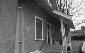
- Photograph of exterior of the Cunningham house located at 3555 Douglas Road, Burnaby. View of the rear of the house with porch. The house was built in 1923 on the property owned by Fred and Edna Cunningham. The Cunningham house was designated as a heritage building in 1996.
- Repository
- Burnaby Village Museum
- Collection/Fonds
- Burnaby Village Museum Photograph collection
- Description Level
- Item
- Physical Description
- 1 photograph : col. negative ; 35 mm
- Scope and Content
- Photograph of exterior of the Cunningham house located at 3555 Douglas Road, Burnaby. View of the rear of the house with porch. The house was built in 1923 on the property owned by Fred and Edna Cunningham. The Cunningham house was designated as a heritage building in 1996.
- Geographic Access
- Douglas Road
- Street Address
- 3555 Douglas Road
- Accession Code
- BV022.3.25
- Access Restriction
- No restrictions
- Reproduction Restriction
- No known restrictions
- Date
- Jan. 1991
- Media Type
- Photograph
- Historic Neighbourhood
- Burnaby Lake (Historic Neighbourhood)
- Planning Study Area
- Douglas-Gilpin Area
- Scan Resolution
- 2400
- Scan Date
- 2021-08-24
- Photographer
- Stevens, Colin
- Notes
- Title based on contents of photograph
- Photograph from Roll P92-4, negative #25
- 1 b&w. print accompanying
- Note in black ink on verso of accompanying photograph print reads: "P92-4-25"
Images

SFU Campus/Residential
https://search.heritageburnaby.ca/link/archivedescription93881
- Repository
- City of Burnaby Archives
- Date
- February 1993
- Collection/Fonds
- Grover, Elliott & Co. Ltd. fonds
- Description Level
- File
- Physical Description
- 24 photographs : col. negatives ; 35 mm
- Scope and Content
- Photographs of the exteriors of four Simon Fraser Univeristy (SFU) campus residences.
- Repository
- City of Burnaby Archives
- Date
- February 1993
- Collection/Fonds
- Grover, Elliott & Co. Ltd. fonds
- Physical Description
- 24 photographs : col. negatives ; 35 mm
- Description Level
- File
- Record No.
- 622-064
- Access Restriction
- No restrictions
- Reproduction Restriction
- No restrictions
- Accession Number
- 2017-39
- Scope and Content
- Photographs of the exteriors of four Simon Fraser Univeristy (SFU) campus residences.
- Names
- Simon Fraser University
- Media Type
- Photograph
- Notes
- Transcribed title
- Title transcribed from envelope photographs were originally housed in
- File no. 93-050-B
- Geographic Access
- Burnaby Mountain Conservation Area
- Planning Study Area
- Burnaby Mountain Area
SFU Rez, Burnaby
https://search.heritageburnaby.ca/link/archivedescription94328
- Repository
- City of Burnaby Archives
- Date
- February 1995
- Collection/Fonds
- Grover, Elliott & Co. Ltd. fonds
- Description Level
- File
- Physical Description
- 24 photographs : col. negatives ; 35 mm
- Scope and Content
- Photographs of the exteriors of Simon Fraser University campus residences, including Shell House, Hamilton Hall, and Townhouses.
- Repository
- City of Burnaby Archives
- Date
- February 1995
- Collection/Fonds
- Grover, Elliott & Co. Ltd. fonds
- Physical Description
- 24 photographs : col. negatives ; 35 mm
- Description Level
- File
- Record No.
- 622-113
- Access Restriction
- No restrictions
- Reproduction Restriction
- No restrictions
- Accession Number
- 2017-39
- Scope and Content
- Photographs of the exteriors of Simon Fraser University campus residences, including Shell House, Hamilton Hall, and Townhouses.
- Names
- Simon Fraser University
- Media Type
- Photograph
- Notes
- Transcribed title
- Title transcribed from envelope photographs were originally housed in
- File no. 95-010-B
- Photographer identified as "J.C."
- Geographic Access
- University Drive
- Street Address
- 8888 University Drive
- Planning Study Area
- Burnaby Mountain Area
![Some of our homes, [1907] thumbnail](/media/hpo/_Data/_Archives_Images/_Unrestricted/371/411-006.jpg?width=280)
Some of our homes
https://search.heritageburnaby.ca/link/archivedescription38347
- Repository
- City of Burnaby Archives
- Date
- [1907]
- Collection/Fonds
- Burnaby Historical Society fonds
- Description Level
- Item
- Physical Description
- 1 photograph : b&w postcard ; 8.5 x 14 cm
- Scope and Content
- Photographic postcard of three houses at Barnet as well as the railway station. A caption on the card reads: "Some of our homes / Barnet B.C."
- Repository
- City of Burnaby Archives
- Date
- [1907]
- Collection/Fonds
- Burnaby Historical Society fonds
- Subseries
- Charles Lee subseries
- Physical Description
- 1 photograph : b&w postcard ; 8.5 x 14 cm
- Description Level
- Item
- Record No.
- 411-006
- Access Restriction
- No restrictions
- Reproduction Restriction
- No known restrictions
- Accession Number
- BHS2000-13
- Scope and Content
- Photographic postcard of three houses at Barnet as well as the railway station. A caption on the card reads: "Some of our homes / Barnet B.C."
- Subjects
- Buildings - Residential - Houses
- Documentary Artifacts - Postcards
- Buildings - Commercial - Train Stations
- Media Type
- Photograph
- Notes
- Title taken from caption
- Geographic Access
- Barnet Village
- Barnet Road
- Street Address
- 8181 Barnet Road
- Historic Neighbourhood
- Barnet (Historic Neighbourhood)
- Planning Study Area
- Burnaby Mountain Area
Images
![Some of our homes, [1907] thumbnail](/media/hpo/_Data/_Archives_Images/_Unrestricted/371/411-006.jpg)
Southern Railway of BC Burnaby
https://search.heritageburnaby.ca/link/archivedescription94306
- Repository
- City of Burnaby Archives
- Date
- February 1994
- Collection/Fonds
- Grover, Elliott & Co. Ltd. fonds
- Description Level
- File
- Physical Description
- 16 photographs : col. negatives ; 35 mm + 1 computer disk ; 14 x 14 cm
- Scope and Content
- Photographs of properties owned by Scott Paper Ltd, including the Doman Sawmill property. Several of the photographs include zoning signs notifying the public that the property is to be developed or redeveloped for Heavy Industrial permitted use.
- Repository
- City of Burnaby Archives
- Date
- February 1994
- Collection/Fonds
- Grover, Elliott & Co. Ltd. fonds
- Physical Description
- 16 photographs : col. negatives ; 35 mm + 1 computer disk ; 14 x 14 cm
- Description Level
- File
- Record No.
- 622-091
- Access Restriction
- No restrictions
- Reproduction Restriction
- No restrictions
- Accession Number
- 2017-39
- Scope and Content
- Photographs of properties owned by Scott Paper Ltd, including the Doman Sawmill property. Several of the photographs include zoning signs notifying the public that the property is to be developed or redeveloped for Heavy Industrial permitted use.
- Subjects
- Buildings - Industrial
- Buildings - Industrial - Mills
- Advertising Medium - Signs and Signboards
- Media Type
- Photograph
- Photographer
- Young, Richard
- Notes
- Transcribed title
- Title transcribed from envelope photographs were originally housed in
- File no. 94-100-O
- Computer disk labelled "Railands.xsl / 2/93"
![Star Wars advance ticket line at Metrotown, [1999] thumbnail](/media/hpo/_Data/_Archives_Images/_Unrestricted/535/535-3175-2.jpg?width=280)
Star Wars advance ticket line at Metrotown
https://search.heritageburnaby.ca/link/archivedescription98095
- Repository
- City of Burnaby Archives
- Date
- [1999]
- Collection/Fonds
- Burnaby NewsLeader photograph collection
- Description Level
- File
- Physical Description
- 2 photographs (tiff) : col.
- Scope and Content
- File contains photographs of people waiting in line for advance tickets for "Star Wars: The Phantom Menace" at the Silver City Metropolis. Photographs depict a group of teenagers playing a board game as they wait and a long line of seated movie-goers in the Metrotown mall with a sign noting the beg…
- Repository
- City of Burnaby Archives
- Date
- [1999]
- Collection/Fonds
- Burnaby NewsLeader photograph collection
- Physical Description
- 2 photographs (tiff) : col.
- Description Level
- File
- Record No.
- 535-3175
- Access Restriction
- No restrictions
- Reproduction Restriction
- No restrictions
- Accession Number
- 2018-12
- Scope and Content
- File contains photographs of people waiting in line for advance tickets for "Star Wars: The Phantom Menace" at the Silver City Metropolis. Photographs depict a group of teenagers playing a board game as they wait and a long line of seated movie-goers in the Metrotown mall with a sign noting the beginning of the line.
- Subjects
- Persons - Adolescents
- Persons - Crowds
- Buildings - Commercial - Cinemas
- Buildings - Commercial - Malls
- Names
- Metrotown
- Media Type
- Photograph
- Photographer
- Bartel, Mario
- Notes
- Title based on caption
- Collected by editorial for use in a May 1999 issue of the Burnaby NewsLeader
- Caption from metadata for 535-3175-1: "Ashley Simmons, 16, passes the time in line for advance tickets to the opening of Star Wars: The Phantom Menace, at Silver City Metropolis, by playing the Star Wars edition of Trivial Pursuit with some of her friends. She says she's seen the three previsions editions of the movie "at least a hundred times each, on video." She says she joined the lineup at about 9:15, three hours before tickets went on sale, because "you wanna go (see the movie) on the first day when everybody's happy and looking forward to it." She says her enthusiasm hasn't been dampened by some of the lukewarm reviews already circulating, "they're not real Star Wars fans." "
- Geographic Access
- Kingsway
- Street Address
- 4700 Kingsway
- Historic Neighbourhood
- Central Park (Historic Neighbourhood)
- Planning Study Area
- Maywood Area
Images
![Star Wars advance ticket line at Metrotown, [1999] thumbnail](/media/hpo/_Data/_Archives_Images/_Unrestricted/535/535-3175-2.jpg)
![Stella Fontana at Lina Coiffures, [1999] thumbnail](/media/hpo/_Data/_Archives_Images/_Unrestricted/535/535-3372-1.jpg?width=280)
Stella Fontana at Lina Coiffures
https://search.heritageburnaby.ca/link/archivedescription98362
- Repository
- City of Burnaby Archives
- Date
- [1999]
- Collection/Fonds
- Burnaby NewsLeader photograph collection
- Description Level
- File
- Physical Description
- 6 photographs (tiff) : col.
- Scope and Content
- File contains photographs of Stella Fontana and the Lina Coiffures hair salon in its former location on Madison Avenue. Photographs depict Fontana with a handwritten appointment book and cutting an unidentified person's hair, as well as items and customers in the hair salon.
- Repository
- City of Burnaby Archives
- Date
- [1999]
- Collection/Fonds
- Burnaby NewsLeader photograph collection
- Physical Description
- 6 photographs (tiff) : col.
- Description Level
- File
- Record No.
- 535-3372
- Access Restriction
- No restrictions
- Reproduction Restriction
- No restrictions
- Accession Number
- 2018-12
- Scope and Content
- File contains photographs of Stella Fontana and the Lina Coiffures hair salon in its former location on Madison Avenue. Photographs depict Fontana with a handwritten appointment book and cutting an unidentified person's hair, as well as items and customers in the hair salon.
- Subjects
- Buildings - Commercial - Barber Shops
- Buildings - Commercial - Beauty Shops
- Occupations - Barbers
- Media Type
- Photograph
- Notes
- Title based on original file name
- Collected by editorial for use in an October 1999 issue of the Burnaby NewsLeader
- Geographic Access
- Madison Avenue
- Charles Street
- Street Address
- 1257 Madison Avenue
- Historic Neighbourhood
- Vancouver Heights (Historic Neighbourhood)
- Planning Study Area
- Willingdon Heights Area
Images
![Stella Fontana at Lina Coiffures, [1999] thumbnail](/media/hpo/_Data/_Archives_Images/_Unrestricted/535/535-3372-1.jpg)
![Stella Fontana in front of Lina Coiffures, [1999] thumbnail](/media/hpo/_Data/_Archives_Images/_Unrestricted/535/535-3376.jpg?width=280)
Stella Fontana in front of Lina Coiffures
https://search.heritageburnaby.ca/link/archivedescription98366
- Repository
- City of Burnaby Archives
- Date
- [1999]
- Collection/Fonds
- Burnaby NewsLeader photograph collection
- Description Level
- Item
- Physical Description
- 1 photograph (tiff) : col.
- Scope and Content
- Photograph of Stella Fontana sweeping the sidewalk in front of the Lina Coiffures hair salon at 1257 Madison Avenue. An unidentified person is sitting in the seats inside the front window and a sign in the window notes that the business is moving to 2523 E Hastings.
- Repository
- City of Burnaby Archives
- Date
- [1999]
- Collection/Fonds
- Burnaby NewsLeader photograph collection
- Physical Description
- 1 photograph (tiff) : col.
- Description Level
- Item
- Record No.
- 535-3376
- Access Restriction
- No restrictions
- Reproduction Restriction
- No restrictions
- Accession Number
- 2018-12
- Scope and Content
- Photograph of Stella Fontana sweeping the sidewalk in front of the Lina Coiffures hair salon at 1257 Madison Avenue. An unidentified person is sitting in the seats inside the front window and a sign in the window notes that the business is moving to 2523 E Hastings.
- Subjects
- Occupations - Barbers
- Buildings - Commercial - Barber Shops
- Buildings - Commercial - Beauty Shops
- Geographic Features - Sidewalks
- Media Type
- Photograph
- Notes
- Title based on original file name
- Collected by editorial for use in an October 1999 issue of the Burnaby NewsLeader
- Geographic Access
- Madison Avenue
- Charles Street
- Street Address
- 1257 Madison Avenue
- Historic Neighbourhood
- Vancouver Heights (Historic Neighbourhood)
- Planning Study Area
- Willingdon Heights Area
Images
![Stella Fontana in front of Lina Coiffures, [1999] thumbnail](/media/hpo/_Data/_Archives_Images/_Unrestricted/535/535-3376.jpg)
![Townhouses, [1999] thumbnail](/media/hpo/_Data/_Archives_Images/_Unrestricted/535/535-3290.jpg?width=280)
Townhouses
https://search.heritageburnaby.ca/link/archivedescription98212
- Repository
- City of Burnaby Archives
- Date
- [1999]
- Collection/Fonds
- Burnaby NewsLeader photograph collection
- Description Level
- Item
- Physical Description
- 1 photograph (tiff) : col.
- Scope and Content
- Photograph of townhouses in an unidentified location.
- Repository
- City of Burnaby Archives
- Date
- [1999]
- Collection/Fonds
- Burnaby NewsLeader photograph collection
- Physical Description
- 1 photograph (tiff) : col.
- Description Level
- Item
- Record No.
- 535-3290
- Access Restriction
- No restrictions
- Reproduction Restriction
- No restrictions
- Accession Number
- 2018-12
- Scope and Content
- Photograph of townhouses in an unidentified location.
- Media Type
- Photograph
- Notes
- Title based on contents of photograph
- Collected by editorial for use in an August 1999 issue of the Burnaby NewsLeader
Images
![Townhouses, [1999] thumbnail](/media/hpo/_Data/_Archives_Images/_Unrestricted/535/535-3290.jpg)
![Tramline tracks, [1905] thumbnail](/media/hpo/_Data/_BVM_Images/1995/1995_0010_0001_001.jpg?width=280)
Tramline tracks
https://search.heritageburnaby.ca/link/museumdescription3361
- Repository
- Burnaby Village Museum
- Date
- [1905]
- Collection/Fonds
- Burnaby Village Museum Photograph collection
- Description Level
- Item
- Physical Description
- 1 photograph : b&w ; 15 x 25.5 cm print
- Scope and Content
- Photograph of a British Columbia Electric Railway Company tramline track on Sixth Street and Twelfth Avenue. George Leaf's General Store, located at 7745 Sixth Street is visible on the left and Cliff's Car Factory located at 7730 Sixth Street is visible on the right. George Leaf's store burned down…
- Repository
- Burnaby Village Museum
- Collection/Fonds
- Burnaby Village Museum Photograph collection
- Description Level
- Item
- Physical Description
- 1 photograph : b&w ; 15 x 25.5 cm print
- Scope and Content
- Photograph of a British Columbia Electric Railway Company tramline track on Sixth Street and Twelfth Avenue. George Leaf's General Store, located at 7745 Sixth Street is visible on the left and Cliff's Car Factory located at 7730 Sixth Street is visible on the right. George Leaf's store burned down in 1913. The Car factory was established in 1902 and sometime in the 1920s, it became James Brookes Woodworking Plant.
- Subjects
- Transportation - Electric Railroads
- Buildings - Commercial - General Stores
- Buildings - Industrial - Factories
- Geographic Access
- 6th Street
- 12th Avenue
- Street Address
- 7730 6th Street
- 7745 6th Street
- Accession Code
- BV995.10.1
- Access Restriction
- No restrictions
- Reproduction Restriction
- No known restrictions
- Date
- [1905]
- Media Type
- Photograph
- Historic Neighbourhood
- East Burnaby (Historic Neighbourhood)
- Planning Study Area
- Edmonds Area
- Scan Resolution
- 600
- Scan Date
- 07-May-24
- Notes
- Title based on contents of photograph
Images
![Tramline tracks, [1905] thumbnail](/media/hpo/_Data/_BVM_Images/1995/1995_0010_0001_001.jpg)
![Walker house, [1990] thumbnail](/media/hpo/_Data/_Archives_Images/_Unrestricted/371/422-003.jpg?width=280)
Walker house
https://search.heritageburnaby.ca/link/archivedescription38372
- Repository
- City of Burnaby Archives
- Date
- [1990]
- Collection/Fonds
- Burnaby Historical Society fonds
- Description Level
- Item
- Physical Description
- 1 photograph : col. ; 8.8 x 13 cm
- Scope and Content
- Photograph of the house built by William and Olive Walker in 1908. This picture shows the home as it looked in 1990.
- Repository
- City of Burnaby Archives
- Date
- [1990]
- Collection/Fonds
- Burnaby Historical Society fonds
- Subseries
- Municipal record subseries
- Physical Description
- 1 photograph : col. ; 8.8 x 13 cm
- Description Level
- Item
- Record No.
- 422-003
- Access Restriction
- No restrictions
- Reproduction Restriction
- Reproduce for fair dealing purposes only
- Accession Number
- BHS2001-09
- Scope and Content
- Photograph of the house built by William and Olive Walker in 1908. This picture shows the home as it looked in 1990.
- Media Type
- Photograph
- Photographer
- Wolf, Jim
- Notes
- Title based on contents of photograph.
- Geographic Access
- Sperling Avenue
- Street Address
- 5255 Sperling Avenue
- Historic Neighbourhood
- Burnaby Lake (Historic Neighbourhood)
- Planning Study Area
- Morley-Buckingham Area
Images
![Walker house, [1990] thumbnail](/media/hpo/_Data/_Archives_Images/_Unrestricted/371/422-003.jpg)
![Woodward cottage, [1990] thumbnail](/media/hpo/_Data/_Archives_Images/_Unrestricted/371/422-001.jpg?width=280)
Woodward cottage
https://search.heritageburnaby.ca/link/archivedescription38370
- Repository
- City of Burnaby Archives
- Date
- [1990]
- Collection/Fonds
- Burnaby Historical Society fonds
- Description Level
- Item
- Physical Description
- 1 photograph : col. ; 9 x 13 cm
- Scope and Content
- Photograph of Woodward cottage as seen from Deer Lake. The cottage was a prefabricted building designed by J.J. Mahoney and architect Joseph Bowman and was manufactured in Vancouver by the B.C. Mills Timber and Trading Company and erected here in 1904. Maude Woodward established a post-office here…
- Repository
- City of Burnaby Archives
- Date
- [1990]
- Collection/Fonds
- Burnaby Historical Society fonds
- Subseries
- Municipal record subseries
- Physical Description
- 1 photograph : col. ; 9 x 13 cm
- Description Level
- Item
- Record No.
- 422-001
- Access Restriction
- No restrictions
- Reproduction Restriction
- Reproduce for fair dealing purposes only
- Accession Number
- BHS2001-09
- Scope and Content
- Photograph of Woodward cottage as seen from Deer Lake. The cottage was a prefabricted building designed by J.J. Mahoney and architect Joseph Bowman and was manufactured in Vancouver by the B.C. Mills Timber and Trading Company and erected here in 1904. Maude Woodward established a post-office here which was operated by her sister, Harriet. Harriet also began a small private school here, the first in Burnaby Lake. The cottage was enlarged with several additions until 1912 when the Woodwards built a new house. This photograph shows the cottage as it appeared in 1990.
- Media Type
- Photograph
- Photographer
- Wolf, Jim
- Notes
- Title based on contents of photograph
- Geographic Access
- Sperling Avenue
- Street Address
- 5141 Sperling Avenue
- Historic Neighbourhood
- Burnaby Lake (Historic Neighbourhood)
- Planning Study Area
- Morley-Buckingham Area
Images
![Woodward cottage, [1990] thumbnail](/media/hpo/_Data/_Archives_Images/_Unrestricted/371/422-001.jpg)
![Louis Claude Hill's Farm, Burnaby, BC, [1909] thumbnail](/media/hpo/_Data/_BVM_Images/1973/1973_0040_0004_001.jpg?width=280)
Louis Claude Hill's Farm, Burnaby, BC
https://search.heritageburnaby.ca/link/museumdescription3064
- Repository
- Burnaby Village Museum
- Date
- [1909]
- Collection/Fonds
- Burnaby Village Museum Photograph collection
- Description Level
- Item
- Physical Description
- 1 photograph : b&w ; 12.2 x 17.6 cm mounted on cardboard 22.7 x 27.4 cm
- Scope and Content
- Photograph of a farm with men, a horse and wagon, and children in a field. An annotation on the back of one of the photos reads, "The foreground farm property stood at the corner of Sperling Avenue (formerly known as the Pole Line Road) and Buckingham. The white house in the left centre was the …
- Repository
- Burnaby Village Museum
- Collection/Fonds
- Burnaby Village Museum Photograph collection
- Description Level
- Item
- Physical Description
- 1 photograph : b&w ; 12.2 x 17.6 cm mounted on cardboard 22.7 x 27.4 cm
- Scope and Content
- Photograph of a farm with men, a horse and wagon, and children in a field. An annotation on the back of one of the photos reads, "The foreground farm property stood at the corner of Sperling Avenue (formerly known as the Pole Line Road) and Buckingham. The white house in the left centre was the residence of Miss Woodward, her mother and sister. It was the first post office at 'Burnaby Lake' and the site of the kindergarten school of Miss Harriet Woodward. It later became the United Church. / The open field in the distance above the horse's head and people in the field is the field in front of the 'Manor House' which was built by Mr. Bateman in the 1920's. To the right of and beyond the white house partly hidden by the trees can be seen some of the buildings associated with the Hill farm on Deer Lake Ave. which by the date (1909) of this photo had been sold. The distant tall trees (center) stand on the site of the Municipal Buildings (DesBirsays Woods)." An annotation on the back of the other photograph reads, "Formerly belonging to Malcom Nicolson / App. 1908." Annotations at the bottom front of the photograph read, "L. Claude Hill's Farm, Burnaby, BC."
- Subjects
- Agriculture - Crops
- Agricultural Tools and Equipment
- Animals - Horses
- Occupations - Farmers
- Agriculture - Farms
- Geographic Access
- Buckingham Avenue
- Sperling Avenue
- Accession Code
- HV973.40.4
- Access Restriction
- No restrictions
- Reproduction Restriction
- No known restrictions
- Date
- [1909]
- Media Type
- Photograph
- Historic Neighbourhood
- Burnaby Lake (Historic Neighbourhood)
- Planning Study Area
- Morley-Buckingham Area
- Scan Resolution
- 600
- Scan Date
- 2023-05-09
- Scale
- 100
- Notes
- Title based on contents of photograph
- 1 b&w duplicate photograph accompanying
- Text on first image "L Claude Hill's Farm, Burnaby B C", incorporated into the image at the bottom edge of the photograph. "app 1909" pencilled in following above on the bottom edge of the image "L. Claude / Hill / Broadview", pencilled on the matt below the image. "The foreground farm property stood at the / Corner of Sperling Ave. (formerly known as Pole Line Road) / and Buckingham. The white house in the left / centre was the residence of Miss Woodward, her mother / and sister. It was the first post ofice at "Burnaby Lake" / and the site of the kindergarten school of Miss / Harriet Woodward. It later became the United / Church. / The open field in the distance above / the horses head and people in the field is / the field in front of the "Manse House" which / was built by Mr. Bateman in the 1920's. To the / right of and beyond the white house partly hidden / by the trees can be seen some of the buildings / associated with the Hill farm on Deer Lake Ave. / which by the date (1909) of this photo had been / sold. The distant tall trees (center) stand on the site of / the Municipal Buildings (DesBirsays Woods)", hand written in blue ink on the reverse side of the matt. It is not indicated who wrote the note. "OR MASTER / 973.40.4", pencilled in the lower right corner of reverse side of matt. "W. T. COOKSLEY / NEW WESTMINSTER, B.C."printed with very little contrast on the gray mattboard, below the lower right corner of the photograph Text on second image. "L Claude Hill's Farm, Burnaby B C", incorporated into the image at the bottom edge of the photograph. "Claude surveying the haying", pencilled on the reverse side of the matt. "Formerly belonging to Malcolm Nicholson / app 1908", hand writen in blue ink on the reverse side of the matt. "H.V.973.40.4. OR. MASTER", hand printed on the bottom left corner of the reverse side of the matt. "W. T. COOKSLEY / NEW WESTMINSTER, B.C."printed with very little contrast on the gray mattboard, below the lower right corner of the photograph
Images
![Louis Claude Hill's Farm, Burnaby, BC, [1909] thumbnail](/media/hpo/_Data/_BVM_Images/1973/1973_0040_0004_001.jpg)

![24-hour relay at Swangard Stadium, [1999] thumbnail](/media/hpo/_Data/_Archives_Images/_Unrestricted/535/535-3231.jpg?width=280)
24-hour relay at Swangard Stadium
https://search.heritageburnaby.ca/link/archivedescription98153
- Repository
- City of Burnaby Archives
- Date
- [1999]
- Collection/Fonds
- Burnaby NewsLeader photograph collection
- Description Level
- Item
- Physical Description
- 1 photograph (tiff) : col.
- Scope and Content
- Photograph of a runner wearing a cow-spotted costume during a 24-hour relay race at Swangard Stadium. Other runners and participants with a banner are on the track behind the runner and many people are sitting in the stands in the background.
- Repository
- City of Burnaby Archives
- Date
- [1999]
- Collection/Fonds
- Burnaby NewsLeader photograph collection
- Physical Description
- 1 photograph (tiff) : col.
- Description Level
- Item
- Record No.
- 535-3231
- Access Restriction
- No restrictions
- Reproduction Restriction
- No restrictions
- Accession Number
- 2018-12
- Scope and Content
- Photograph of a runner wearing a cow-spotted costume during a 24-hour relay race at Swangard Stadium. Other runners and participants with a banner are on the track behind the runner and many people are sitting in the stands in the background.
- Names
- Swangard Stadium
- Media Type
- Photograph
- Notes
- Title based on contents of photograph
- Collected by editorial for use in a June 1999 issue of the Burnaby NewsLeader
- Geographic Access
- Central Park
- Imperial Street
- Street Address
- 3883 Imperial Street
- Historic Neighbourhood
- Central Park (Historic Neighbourhood)
- Planning Study Area
- Maywood Area
Images
![24-hour relay at Swangard Stadium, [1999] thumbnail](/media/hpo/_Data/_Archives_Images/_Unrestricted/535/535-3231.jpg)
106-7450 lowland [sic] dr
https://search.heritageburnaby.ca/link/archivedescription93811
- Repository
- City of Burnaby Archives
- Date
- September 1992
- Collection/Fonds
- Grover, Elliott & Co. Ltd. fonds
- Description Level
- File
- Physical Description
- 17 photographs : col. negative ; 35 mm
- Scope and Content
- Photographs of the exterior of a two-storey commercial building located 7450 Lowland Drive. Tenant businesses visible in the photographs include Dura-Log and Kango.
- Repository
- City of Burnaby Archives
- Date
- September 1992
- Collection/Fonds
- Grover, Elliott & Co. Ltd. fonds
- Physical Description
- 17 photographs : col. negative ; 35 mm
- Description Level
- File
- Record No.
- 622-059
- Access Restriction
- No restrictions
- Reproduction Restriction
- No restrictions
- Accession Number
- 2017-39
- Scope and Content
- Photographs of the exterior of a two-storey commercial building located 7450 Lowland Drive. Tenant businesses visible in the photographs include Dura-Log and Kango.
- Subjects
- Buildings - Commercial - Offices
- Media Type
- Photograph
- Notes
- Transcribed title
- Title transcribed from envelope photographs were originally housed in
- File no. 92-346-B
- Geographic Access
- Lowland Drive
- Street Address
- 7450 Lowland Drive
- Historic Neighbourhood
- Fraser Arm (Historic Neighbourhood)
- Planning Study Area
- Big Bend Area
#221-3823 Henning Dr, Burnaby
https://search.heritageburnaby.ca/link/archivedescription94353
- Repository
- City of Burnaby Archives
- Date
- 1998
- Collection/Fonds
- Grover, Elliott & Co. Ltd. fonds
- Description Level
- File
- Physical Description
- 10 photographs : col. negatives ; 35 mm
- Scope and Content
- Photographs of the exterior of a two-storey commercial building located at 3823 Henning Drive.
- Repository
- City of Burnaby Archives
- Date
- 1998
- Collection/Fonds
- Grover, Elliott & Co. Ltd. fonds
- Physical Description
- 10 photographs : col. negatives ; 35 mm
- Description Level
- File
- Record No.
- 622-138
- Access Restriction
- No restrictions
- Reproduction Restriction
- No restrictions
- Accession Number
- 2017-39
- Scope and Content
- Photographs of the exterior of a two-storey commercial building located at 3823 Henning Drive.
- Subjects
- Buildings - Residential
- Media Type
- Photograph
- Notes
- Transcribed title
- Title transcribed from envelope photographs were originally housed in
- File no. 98-247-B
- Geographic Access
- Henning Drive
- Street Address
- 3823 Henning Drive
- Historic Neighbourhood
- Broadview (Historic Neighbourhood)
- Planning Study Area
- West Central Valley Area
1160 Douglas Rd
https://search.heritageburnaby.ca/link/archivedescription94327
- Repository
- City of Burnaby Archives
- Date
- December 1994
- Collection/Fonds
- Grover, Elliott & Co. Ltd. fonds
- Description Level
- File
- Physical Description
- 22 photographs : col. negatives ; 35 mm
- Scope and Content
- Photographs of the exterior of a three-storey commerical building located at 1160 Douglas Road.
- Repository
- City of Burnaby Archives
- Date
- December 1994
- Collection/Fonds
- Grover, Elliott & Co. Ltd. fonds
- Physical Description
- 22 photographs : col. negatives ; 35 mm
- Description Level
- File
- Record No.
- 622-112
- Access Restriction
- No restrictions
- Reproduction Restriction
- No restrictions
- Accession Number
- 2017-39
- Scope and Content
- Photographs of the exterior of a three-storey commerical building located at 1160 Douglas Road.
- Media Type
- Photograph
- Photographer
- Young, Richard
- Notes
- Transcribed title
- Title transcribed from envelope photographs were originally housed in
- File no. 94-424-B
- Geographic Access
- Douglas Road
- Street Address
- 1160 Douglas Road
- Historic Neighbourhood
- Vancouver Heights (Historic Neighbourhood)
- Planning Study Area
- Willingdon Heights Area
1850 Rosser Ave Burnaby
https://search.heritageburnaby.ca/link/archivedescription93890
- Repository
- City of Burnaby Archives
- Date
- June 1993
- Collection/Fonds
- Grover, Elliott & Co. Ltd. fonds
- Description Level
- File
- Physical Description
- 35 photographs : col. negatives ; 35 mm
- Scope and Content
- Photographs of an 18-storey residential tower located at 1850 Rosser Avenue.
- Repository
- City of Burnaby Archives
- Date
- June 1993
- Collection/Fonds
- Grover, Elliott & Co. Ltd. fonds
- Physical Description
- 35 photographs : col. negatives ; 35 mm
- Description Level
- File
- Record No.
- 622-073
- Access Restriction
- No restrictions
- Reproduction Restriction
- No restrictions
- Accession Number
- 2017-39
- Scope and Content
- Photographs of an 18-storey residential tower located at 1850 Rosser Avenue.
- Subjects
- Buildings - Residential
- Media Type
- Photograph
- Notes
- Transcribed title
- Title transcribed from envelope photographs were originally housed in
- File no. 93-268-B
- Note in blue pen on photograph envelope reads: "Rideau Manor".
- Photographer identified as "D.E."
- Geographic Access
- Rosser Avenue
- Street Address
- 1850 Rosser Avenue
- Historic Neighbourhood
- Vancouver Heights (Historic Neighbourhood)
- Planning Study Area
- Willingdon Heights Area