More like 'Interview with Reidun Seim by Kathy Bossort January 13, 2016 - Track 1'
Narrow Results By
Decade
- 2020s 132
- 2010s 89
- 2000s 1026
- 1990s 585
- 1980s
- 1970s 1079
- 1960s 386
- 1950s 591
- 1940s 610
- 1930s 490
- 1920s 528
- 1910s 524
- 1900s
- 1890s 42
- 1880s 53
- 1870s
- 1860s 4
- 1850s 1
- 1840s 1
- 1830s 2
- 1820s 1
- 1810s 1
- 1800s 1
- 1790s 1
- 1780s 1
- 1770s 1
- 1760s 1
- 1750s 1
- 1740s 1
- 1730s 1
- 1720s 1
- 1710s 1
- 1700s 1
- 1690s 1
- 1680s 1
- 1670s 1
- 1660s 1
- 1650s 1
- 1640s 1
- 1630s 1
- 1620s 1
- 1610s 1
- 1600s 1

Duncan & Margaret McGregor Estate 'Glen-Lyon' Mansion
https://search.heritageburnaby.ca/link/landmark518
- Repository
- Burnaby Heritage Planning
- Description
- Overlooking the rich farmland of the Fraser River floodplain, 'Glen-Lyon' is an Edwardian era rural estate, with a tall, two and one-half storey plus basement wood-frame mansion, set in a pastoral and formal landscape with an associated barn and early log pond, located near a ravine and forested ar…
- Associated Dates
- 1902
- Formal Recognition
- Heritage Designation, Community Heritage Register
- Street View URL
- Google Maps Street View
- Repository
- Burnaby Heritage Planning
- Geographic Access
- Marine Drive
- Associated Dates
- 1902
- Formal Recognition
- Heritage Designation, Community Heritage Register
- Enactment Type
- Bylaw No. 12183
- Enactment Date
- 11/12/2006
- Description
- Overlooking the rich farmland of the Fraser River floodplain, 'Glen-Lyon' is an Edwardian era rural estate, with a tall, two and one-half storey plus basement wood-frame mansion, set in a pastoral and formal landscape with an associated barn and early log pond, located near a ravine and forested area adjacent to Marine Drive in South Burnaby.
- Heritage Value
- ‘Glen-Lyon’ is valued as an excellent example of a privately-owned Edwardian era country estate built at the turn of the nineteenth century. The property retains significant heritage features including the Edwardian era mansion with rustic Arts and Crafts features, and elements of a working agricultural landscape. The property was originally the Royal City Mills logging camp, and in 1900 was purchased by Duncan Campbell McGregor (1853-1929) and Margaret Jane McGregor (1875-1960), who named their estate ‘Glen-Lyon’ after Duncan McGregor’s birthplace in Perthshire, Scotland. The McGregors were active in municipal affairs and social activities, and played a significant role in the early development of Burnaby. Duncan McGregor served as a city councillor from 1909 to 1912 and was elected reeve of Burnaby in 1913. Margaret McGregor was instrumental in the formation and fundraising activities of the Victoria Order of Nurses in Burnaby. Additionally, the site is historically significant for its association with early social welfare and correctional reform. The estate was sold in 1926 to an inter-denominational religious organization called the Home of the Friendless, which used it as their B.C. headquarters. The organization was charged with several cases of abuse and neglect in 1937, after which a Royal Commission was formed that led to new legislation to regulate and license all private welfare institutions. 'Glen-Lyon' was sold to the provincial government, and was dedicated in 1939 by the Lt.-Gov. E.W. Hamber for use as the New Haven Borstal Home for Boys and Youthful Offenders (later renamed the New Haven Correction Centre). The Borstal movement originated in England in the late nineteenth century, as an alternative to sending young offenders and runaways to prisons by providing reformatories that focused on discipline and vocational skill. This site’s role as the first North American institution devoted to the Borstal School philosophy was historic, and influenced corrections programs across Canada. The site retains significant features from its development in 1939 as the Borstal School, including a large gambrel-roofed barn designed by Chief Provincial Architect Henry Whittaker of the Department of Public Works that is the only remaining structure of its kind in Burnaby. Between 1941 and 1945 the mansion housed the Provincial School for the Deaf and Blind when the Borstal School was closed temporarily as a war measure during the Second World War.
- Defining Elements
- Key elements that define the heritage character of 'Glen-Lyon' Mansion include its: - location on a sloping site with expansive southern exposure, adjacent to Marine Drive - residential form, scale and massing of the house as exemplified by its two and one-half storey height, above-ground basement and rectangular plan - Arts and Crafts elements of the house such as its stone foundation, multi-gabled roof line with steep central hipped roof, symmetrical cross-gables, side shed dormers, bellcast upper walls sheathed in cedar shingles and lower walls sheathed in narrow clapboard - original exterior features of the house such as the full width front verandah with square columns, central staircase on the southern elevation, original doors and stained glass windows; and the irregular fenestration such as double-hung 1-over-1 wooden-sash windows, bay windows, and projecting windows in the gable ends - original interior features of the house such as the U-shaped main stair designed around two symmetrically placed Ionic columns, and interior trim on the main floor including boxed beams and fireplaces - gambrel-roofed barn with roof vent with finial, sliding hay loft and access doors, small multi-pane windows, and lapped wooden siding - associated landscape features such as the original garden plantings with some exotic and many native specimen trees; the original log pond and its concrete Marine Drive causeway and culvert; rockeries and a rose garden
- Historic Neighbourhood
- Fraser Arm (Historic Neighbourhood)
- Planning Study Area
- Big Bend Area
- Architect
- Henry Whittaker
- Function
- Primary Historic--Estate
- Community
- Burnaby
- Cadastral Identifier
- 003-004-661
- Boundaries
- 'Glen-Lyon' is comprised of a single residential lot located at 4250 Marine Drive, Burnaby.
- Area
- 230873.18
- Contributing Resource
- Building
- Ownership
- Private
- Names
- McGregor, Duncan C. (1853-1929)
- Whittaker, Henry
- Home of the Friendless
- Borstal School
- New Haven Correction Centre
- Subjects
- Buildings - Heritage
- Buildings - Residential - Houses
- Buildings - Public - Detention Facilities
- Buildings - Residential
- Street Address
- 4250 Marine Drive
- Street View URL
- Google Maps Street View
Images


H.T. Ceperley Estate 'Fairacres' Steam Plant Building
https://search.heritageburnaby.ca/link/landmark528
- Repository
- Burnaby Heritage Planning
- Description
- Designed in the British Arts and Crafts style, the ‘Fairacres’ Steam Plant Buiding is a single-storey wood frame building with a gabled roof that originally housed the apparatus for climate control in the greenhouses, formerly located to its north. The original rubble stone walls that formed the fo…
- Associated Dates
- 1908
- Formal Recognition
- Heritage Designation, Community Heritage Register
- Repository
- Burnaby Heritage Planning
- Geographic Access
- Deer Lake Avenue
- Associated Dates
- 1908
- Formal Recognition
- Heritage Designation, Community Heritage Register
- Enactment Type
- Bylaw No. 9807
- Enactment Date
- 23/11/1992
- Description
- Designed in the British Arts and Crafts style, the ‘Fairacres’ Steam Plant Buiding is a single-storey wood frame building with a gabled roof that originally housed the apparatus for climate control in the greenhouses, formerly located to its north. The original rubble stone walls that formed the foundation for the greenhouses stand adjacent. The Steam Plant Building stands as a pendant to the Root House, which is to the north of the former greenhouses.
- Heritage Value
- The outbuildings at 'Fairacres' are a rare surviving architecturally-designed ensemble of agricultural structures that exist in complementary harmony with the main estate house. Architect Robert Mackay Fripp (1858-1917), an outspoken advocate of Arts and Crafts design, was retained by the Ceperleys to design several original outbuildings on their estate. The Ceperleys operated 'Fairacres' with staff, a farm manager and workers, including Chinese, to grow produce for themselves and for sale at local markets. The Steam Plant Building illustrates the market gardening activity of the area around Deer Lake and its importance to the Ceperley family, which valued a year-round supply of fresh fruit and vegetables for the kitchen and flowers for the house. It also illustrates the cultural and aesthetic values of the Ceperleys in retaining an architect to design a functional outbuilding using an accepted and contemporary architectural style. Built in 1908, the Steam Plant Building was significantly altered in the 1960s and restored to its original design in 2000.
- Defining Elements
- Key elements that define the heritage character of the ‘Fairacres’ Steam Plant Building include its: - overall spatial arrangement of the Steam Plant Building in relation to the former greenhouses and the Root House - side gable roof with cedar shingle cladding. - tall brick chimney indicitive of the building's original function. - distinctive Arts and Crafts architectural features such as the shingle wall cladding with decorative shingling under window sills, deep eaves, and pebble-dashed concrete foundation walls - six-paned wooden-sash casement windows - simple functional interior features - rubble stone walls that formed the foundation for the greenhouses
- Locality
- Deer Lake Park
- Historic Neighbourhood
- Burnaby Lake (Historic Neighbourhood)
- Planning Study Area
- Douglas-Gilpin Area
- Architect
- Robert Mackay Fripp
- Function
- Primary Historic--Outbuilding
- Community
- Burnaby
- Cadastral Identifier
- P.I.D. No. 004-493-311 Legal Description: Block 3 Except: Part subdivided by Plan 26865, District Lot 79, Group 1, New Westminster District, Plan 536
- Boundaries
- ‘Fairacres’ is comprised of a single municipally-owned property located at 6344 Deer Lake Avenue, Burnaby.
- Area
- 17,065.00
- Contributing Resource
- Building
- Landscape Feature
- Ownership
- Public (local)
- Other Collection
- Burnaby Historical Society, Community Archives: Ceperley Photograph Album
- Documentation
- Heritage Site Files: PC77000 20. City of Burnaby Planning and Building Department, 4949 Canada Way, Burnaby, B.C., V5G 1M2
- Street Address
- 6344 Deer Lake Avenue
Images


H.T. Ceperley Estate 'Fairacres' Greenhouse Foundation Wall
https://search.heritageburnaby.ca/link/landmark862
- Repository
- Burnaby Heritage Planning
- Description
- The original rubble stone walls that formed the foundation for a greenhouses adjacent to the Steam Plant Building provided heat to several greenhouses on the estate propoerty. The Root House, which is to the north of the Greenhouse Foundation Wall, provided storage for the farm operation.
- Associated Dates
- 1908
- Formal Recognition
- Heritage Designation, Community Heritage Register
- Repository
- Burnaby Heritage Planning
- Geographic Access
- Deer Lake Avenue
- Associated Dates
- 1908
- Formal Recognition
- Heritage Designation, Community Heritage Register
- Enactment Type
- Bylaw No. 140665
- Enactment Date
- 23/11/1992
- Description
- The original rubble stone walls that formed the foundation for a greenhouses adjacent to the Steam Plant Building provided heat to several greenhouses on the estate propoerty. The Root House, which is to the north of the Greenhouse Foundation Wall, provided storage for the farm operation.
- Heritage Value
- The outbuildings at 'Fairacres' are a rare surviving architecturally-designed ensemble of agricultural structures that exist in complementary harmony with the main estate house. Architect Robert Mackay Fripp (1858-1917), an outspoken advocate of Arts and Crafts design, was retained by the Ceperleys to design several original outbuildings on their estate, which was designed as a country estate with a working farm that included over 10 acres of productive berry and vegetable fields, with a large kitchen garden, a root house to store food, an orchard, and greenhouses heated by steam. The agricultural potential of the Deer Lake area made it one of the first parts of the municipality to attract settlement. In 1909, the Ceperleys built three large greenhouses heated by an adjacent steam plant (Fairacres Steam Plant). The greenhouses featured granite foundation walls, including this one which remains intact. The Ceperleys employed a large staff to manage the estate's agricultural production, including Chinese farm labourers. Produce was grown for use at the estate, and for sale at local markets. Agricultural use of the estate continued when a Catholic order of Benedictine monks purchased the estate as part of the Priory of St. Joseph and the Seminary of Christ the King, and continued to farm the land until 1953.
- Defining Elements
- Key elements that define the heritage character of the ‘Fairacres’ Steam Plant Building include its: - overall spatial arrangement of the Greenhouse Foundation Wall in relation to the Steam Plant Building and the Root House - original rubble stone walls reflecting the Arts and Crafts design aesthetic of the estate buildings.
- Locality
- Deer Lake Park
- Historic Neighbourhood
- Burnaby Lake (Historic Neighbourhood)
- Planning Study Area
- Douglas-Gilpin Area
- Architect
- Robert Mackay Fripp
- Function
- Primary Historic--Outbuilding
- Community
- Burnaby
- Cadastral Identifier
- P.I.D. No. 004-493-311 Legal Description: Block 3 Except: Part subdivided by Plan 26865, District Lot 79, Group 1, New Westminster District, Plan 536
- Boundaries
- ‘Fairacres’ is comprised of a single municipally-owned property located at 6344 Deer Lake Avenue, Burnaby.
- Area
- 17,065.00
- Contributing Resource
- Landscape Feature
- Remains
- Ownership
- Public (local)
- Other Collection
- Burnaby Historical Society, Community Archives: Ceperley Photograph Album
- Documentation
- Heritage Site Files: PC77000 20. City of Burnaby Planning and Building Department, 4949 Canada Way, Burnaby, B.C., V5G 1M2
- Street Address
- 6344 Deer Lake Avenue
Images


H.T. Ceperley Estate 'Fairacres' Root House
https://search.heritageburnaby.ca/link/landmark527
- Repository
- Burnaby Heritage Planning
- Description
- The ‘Fairacres’ Root House is a long, low one-storey masonry building, measuring 4.6 metres by 9.1 metres, with massively buttressed concrete walls and foundations. Built into sloping ground adjacent to the location of the former greenhouses, the surviving orchard and the kitchen entrance of the ma…
- Associated Dates
- 1908
- Formal Recognition
- Heritage Designation, Community Heritage Register
- Repository
- Burnaby Heritage Planning
- Geographic Access
- Deer Lake Avenue
- Associated Dates
- 1908
- Formal Recognition
- Heritage Designation, Community Heritage Register
- Enactment Type
- Bylaw No. 9807
- Enactment Date
- 23/11/1992
- Description
- The ‘Fairacres’ Root House is a long, low one-storey masonry building, measuring 4.6 metres by 9.1 metres, with massively buttressed concrete walls and foundations. Built into sloping ground adjacent to the location of the former greenhouses, the surviving orchard and the kitchen entrance of the main house, 'Fairacres,' this functional structure was used as a frost-free store for fruit and vegetables for the family's use.
- Heritage Value
- The outbuildings at 'Fairacres' are a rare surviving architecturally-designed ensemble of agricultural structures that exist in complementary harmony with the main estate house. Architect Robert Mackay Fripp (1858-1917), an outspoken advocate of Arts and Crafts design, was retained by the Ceperleys to design several original outbuildings on their estate. The Root House is important as a rare surviving, and exceptionally large, example of this building type in the Vancouver region. Unusual in the fact that an architect designed a building of such modest aspirations, it is also remarkable in its method of construction. The use of concrete as a structural material is one of the earliest in the region and extraordinary for its use on such a modest vernacular outbuilding; root cellars were typically built of loose stone. Built in 1908, the Root House was significantly altered in the 1960s and restored to its original design in 2000. The building is significant as an indicator of the market gardening activity in the area around Deer Lake and of the country-house self-sufficiency practiced by the Ceperley family. The Root House illustrates the cultural, aesthetic, and lifestyle values of the Ceperleys in constructing such a large building for storing their own produce.
- Defining Elements
- The outbuildings at 'Fairacres' are a rare surviving architecturally-designed ensemble of agricultural structures that exist in complementary harmony with the main estate house. Architect Robert Mackay Fripp (1858-1917), an outspoken advocate of Arts and Crafts design, was retained by the Ceperleys to design several original outbuildings on their estate. The Root House is important as a rare surviving, and exceptionally large, example of this building type in the Vancouver region. Unusual in the fact that an architect designed a building of such modest aspirations, it is also remarkable in its method of construction. The use of concrete as a structural material is one of the earliest in the region and extraordinary for its use on such a modest vernacular outbuilding; root cellars were typically built of loose stone. Built in 1908, the Root House was significantly altered in the 1960s and restored to its original design in 2000. The building is significant as an indicator of the market gardening activity in the area around Deer Lake and of the country-house self-sufficiency practiced by the Ceperley family. The Root House illustrates the cultural, aesthetic, and lifestyle values of the Ceperleys in constructing such a large building for storing their own produce.
- Locality
- Deer Lake Park
- Historic Neighbourhood
- Burnaby Lake (Historic Neighbourhood)
- Planning Study Area
- Douglas-Gilpin Area
- Architect
- Robert Mackay Fripp
- Function
- Primary Historic--Outbuilding
- Secondary Historic--Food Storage
- Community
- Burnaby
- Cadastral Identifier
- P.I.D. No. 004-493-311 Legal Description: Block 3 Except: Part subdivided by Plan 26865, District Lot 79, Group 1, New Westminster District, Plan 536
- Boundaries
- ‘Fairacres’ is comprised of a single municipally-owned property located at 6344 Deer Lake Avenue, Burnaby.
- Area
- 17,065.00
- Contributing Resource
- Building
- Landscape Feature
- Ownership
- Public (local)
- Other Collection
- Burnaby Historical Society, Community Archives: Ceperley Photograph Album
- Documentation
- Heritage Site Files: PC77000 20. City of Burnaby Planning and Building Department, 4949 Canada Way, Burnaby, B.C., V5G 1M2
- Street Address
- 6344 Deer Lake Avenue
Images

, copied 1978 thumbnail](/media/hpo/_Data/_BVM_Images/1978/1978_0001_0003_001.jpg?width=280)
Haszard house
https://search.heritageburnaby.ca/link/museumdescription449
- Repository
- Burnaby Village Museum
- Date
- [190-](date of original), copied 1978
- Collection/Fonds
- Burnaby Village Museum Photograph collection
- Description Level
- Item
- Physical Description
- 1 photograph : b&w ; 20.2 x 25.2 cm print
- Scope and Content
- Photograph of a house in a clearing just on the outskirts of densely wooded area. There is a wooden fence around the property, and in front of the house is a dirt road. There are small piles of logs along the road side. An earlier catalogue record identifies this house as the Haszard house that was…
- Repository
- Burnaby Village Museum
- Collection/Fonds
- Burnaby Village Museum Photograph collection
- Description Level
- Item
- Physical Description
- 1 photograph : b&w ; 20.2 x 25.2 cm print
- Scope and Content
- Photograph of a house in a clearing just on the outskirts of densely wooded area. There is a wooden fence around the property, and in front of the house is a dirt road. There are small piles of logs along the road side. An earlier catalogue record identifies this house as the Haszard house that was located across the street from the property of the Sprott Farm. The photograph was taken from Douglas Road (later renamed in part Canada Way). It is also noted that the Sprott family lived in the Haszard house while their home, named "Dovecote" was being completed.
- Geographic Access
- Douglas Road
- Canada Way
- Accession Code
- HV978.1.3
- Access Restriction
- No restrictions
- Reproduction Restriction
- No known restrictions
- Date
- [190-](date of original), copied 1978
- Media Type
- Photograph
- Historic Neighbourhood
- Burnaby Lake (Historic Neighbourhood)
- Scan Resolution
- 600
- Scan Date
- 2023-07-25
- Notes
- Title based on contents of photograph
Images
, copied 1978 thumbnail](/media/hpo/_Data/_BVM_Images/1978/1978_0001_0003_001.jpg)
![Sprott sisters sitting together on a long tressle. Helen Sprott is seated on the right, wearing glasses [1906]. Item no. HV978.1.10 thumbnail](/media/hpo/_Data/_Archives_Images/_Unrestricted/1977/197800010010.jpg?width=280)
Interview with Helen Sprott August 10, 1977 - Track 1
https://search.heritageburnaby.ca/link/oralhistory207
- Repository
- City of Burnaby Archives
- Date Range
- 1900-1908
- Length
- 0:05:47
- Summary
- This portion of the interview pertains to Helen Fanny Sprott's memories of her family's first years of living in Burnaby. She mentions the Hazard House and Mayfield Farms.
- Repository
- City of Burnaby Archives
- Summary
- This portion of the interview pertains to Helen Fanny Sprott's memories of her family's first years of living in Burnaby. She mentions the Hazard House and Mayfield Farms.
- Date Range
- 1900-1908
- Photo Info
- Sprott sisters sitting together on a long tressle. Helen Sprott is seated on the right, wearing glasses [1906]. Item no. HV978.1.10
- Length
- 0:05:47
- Subjects
- Buildings - Residences - Houses
- Geographic Access
- Canada Way
- Burnaby Lake
- Historic Neighbourhood
- Burnaby Lake (Historic Neighbourhood)
- Planning Study Area
- Morley-Buckingham Area
- Interview Date
- August 10, 1977
- Scope and Content
- Recording is of an interview with Helen Sprott, August 10, 1977. Major themes discussed are: the Sprott home.
- Biographical Notes
- Helen Sprott was born in Burnaby on June 22, 1902. Her father, Louis Edgar Sprott and younger brother came out to Burnaby from England, following their older brother Charles F. Sprott. The two younger brothers were in the Merchant Marines together prior to arriving in to Burnaby and learning to farm. Louis Edgar Sprott and Helen Louise F. Nicholls were married June 30, 1900 and stayed at the Haszard House while their own house was being built. By 1902, "the Dovecote" was built and Helen was born. The house was added on to and later renamed "Mayfield Farms." Helen's grandmother and aunt on her mother's side came to live at Mayfield Farms in 1907 or 1908. Helen Sprott was living in Penticton at the time of her death, April 8, 1978 at the age of seventy-five.
- Total Tracks
- 2
- Total Length
- 0:08:57
- Interviewee Name
- Sprott, Helen
- Collection/Fonds
- Burnaby Historical Society fonds
- Subseries
- Oral history subseries
- Media Type
- Sound Recording
Images
![Sprott sisters sitting together on a long tressle. Helen Sprott is seated on the right, wearing glasses [1906]. Item no. HV978.1.10 thumbnail](/media/hpo/_Data/_Archives_Images/_Unrestricted/1977/197800010010.jpg)
Audio Tracks
Track one of interview with Helen Sprott
Track one of interview with Helen Sprott
https://search.heritageburnaby.ca/media/hpo/_Data/_Archives_Oral_Histories/_Unrestricted/MSS137-019-2/MSS137-019-2_Track_1.mp3Interview with John Mallory June 24, 1975 - Track 1
https://search.heritageburnaby.ca/link/oralhistory118
- Repository
- City of Burnaby Archives
- Date Range
- 1903-1929
- Length
- 0:10:02
- Summary
- This portion of the interview pertains to John Mallory's early life and his first years in Burnaby dealing with delinquency of mortgage payments on his home. He also begins to discuss his political involvement with the labour movement.
- Repository
- City of Burnaby Archives
- Summary
- This portion of the interview pertains to John Mallory's early life and his first years in Burnaby dealing with delinquency of mortgage payments on his home. He also begins to discuss his political involvement with the labour movement.
- Date Range
- 1903-1929
- Length
- 0:10:02
- Subjects
- Buildings - Residences - Houses
- Geographic Access
- 11th Avenue
- 15th Street
- Interviewer
- Bradbury, Dr. Bettina
- Interview Date
- June 24, 1975
- Scope and Content
- Recording is of an interview with John Mallory by Simon Fraser University (SFU) masters student Bettina Bradbury June 24, 1975. Major themes discussed are: the Depression and the Unemployment movement. To view "Narrow By" terms for each track expand this description and see "Notes".
- Biographical Notes
- John Audrey Mallory was born in Carman, Manitoba on January 10, 1903 to John and Bertha Nina (Rodgers) Mallory. The Mallory family moved to Deep Creek, British Columbia for a time before arriving in New Westminster. John Audrey Mallory married Janet Ellis Morice on November 15, 1924. John Mallory helped to build a mill at Powell River where he played baseball before he moved to Burnaby in the late 1920s. He built a house at 11th Avenue and 13th Street. He later moved to 1851 4th Street, working a few months out of the year as a construction foreman. He also worked renovating various mills. Towards the end of the thirties, he had established his own heating and plumbing business. John Mallory was very active in the labour movement, beginning with the Independent Labour Party which was renamed the Independent Labour Party Socialists, then the Socialist Party of Canada. He joined the Workers' Unity League (WUL) and their affiliates the Unemployed Workers Association at this time as well. Together with fellow organizers, John fixed up the Edmonds Hall and held fundraising parties for the Unemployment movement. Seen by others as an agitator, John organized countless strike movements, protests and demonstrations in his capacity as an organizer for the Workers' Unity League. John left the Socialist Party of Canada due to what he saw as their intolerance with other parts of the working class movement to join the Communist Party of Canada. He was later expelled from the Communist Party for "Trotskist leanings." Bertha Nina (Rodgers) Mallory died May 20, 1964 at the age of eighty-two. Her husband John Mallory died April 1, 1966 at the age of ninety-four. John Audrey Mallory died July 7, 1981 at the age of seventy-eight.
- Total Tracks
- 13
- Total Length
- 1:56:06
- Interviewee Name
- Mallory, John
- Interviewer Bio
- Bettina Bradbury teaches history and women's studies at York University. She is the author of Wife to Widow. Lives, Laws and Politics in Nineteenth-century Montreal. (Vancouver: University of British Columbia Press, June 2011), 520p; Working Families. Age, Gender and Daily Survival in Industrializing Montreal. (Toronto: Canadian Social History Series, McClelland and Stewart, 1993); (Republished Toronto: Oxford University Press, 1996) (3rd edition, Toronto: University of Toronto Press, 2007). These interviews were undertaken after she completed her MA at Simon Fraser University in 1975 with the support of an LIP grant.
- Collection/Fonds
- Burnaby Historical Society fonds
- Subseries
- Oral history subseries
- Media Type
- Sound Recording
- Web Notes
- Interview was digitized in 2010 allowing it to be accessible on Heritage Burnaby. The digitization project was initiated by the Community Heritage Commission with support from City of Burnaby Council and the BC History Digitization Program of the Irving K. Barber Learning Centre, University of British Columbia. It was recognized by the Heritage Society of BC with an award in 2012.
Audio Tracks
Track one of interview with John Mallory
Track one of interview with John Mallory
https://search.heritageburnaby.ca/media/hpo/_Data/_Archives_Oral_Histories/_Unrestricted/100-13-11/100-13-11_Track_1.mp3Interview with Kathleen Rose July 14, 1975 - Track 1
https://search.heritageburnaby.ca/link/oralhistory146
- Repository
- City of Burnaby Archives
- Date Range
- 1897-1934
- Length
- 0:10:37
- Summary
- This portion of the interview pertains to Kathleen Rose's first memories of coming to North Burnaby as well as of her husband's employment. She discusses quilt-making among families experiencing economic hardship.
- Repository
- City of Burnaby Archives
- Summary
- This portion of the interview pertains to Kathleen Rose's first memories of coming to North Burnaby as well as of her husband's employment. She discusses quilt-making among families experiencing economic hardship.
- Date Range
- 1897-1934
- Length
- 0:10:37
- Subjects
- Buildings - Residences - Houses
- Geographic Access
- Albert Street
- Historic Neighbourhood
- Capitol Hill (Historic Neighbourhood)
- Planning Study Area
- Capitol Hill Area
- Interviewer
- Bradbury, Dr. Bettina
- Interview Date
- July 14, 1975
- Scope and Content
- Recording is of an interview with Kathleen Rose by SFU (Simon Fraser University) student Bettina Bradbury, July 14, 1975. Major theme discussed is: the Depression.
- Biographical Notes
- Kathleen Rose was born in Dublin, Ireland in 1897 and immigrated to Prince Albert, Saskatchewan in 1907 with her family. Kathleen lived on the Prairie for eighteen years before getting married in 1923 and moving to Burnaby to be with her husband. The couple moved to the 4600 block of Albert Street in North Burnaby, where Kathleen’s husband cleared all of the land by hand. The Roses had help putting in the foundation but otherwise built their house themselves. Kathleen’s husband was a longshoreman at that time. They had a son, born in 1925, who suffered from rheumatic fever during the Depression.
- Total Tracks
- 4
- Total Length
- 0:35:42
- Interviewee Name
- Rose, Kathleen
- Interviewer Bio
- Bettina Bradbury teaches history and women's studies at York University. She is the author of Wife to Widow. Lives, Laws and Politics in Nineteenth-century Montreal. (Vancouver: University of British Columbia Press, June 2011), 520p; Working Families. Age, Gender and Daily Survival in Industrializing Montreal. (Toronto: Canadian Social History Series, McClelland and Stewart, 1993); (Republished Toronto: Oxford University Press, 1996) (3rd edition, Toronto: University of Toronto Press, 2007). These interviews were undertaken after she completed her MA at Simon Fraser University in 1975 with the support of an LIP grant.
- Collection/Fonds
- Burnaby Historical Society fonds
- Subseries
- Oral history subseries
- Media Type
- Sound Recording
- Web Notes
- Interview was digitized in 2010 allowing it to be accessible on Heritage Burnaby. The digitization project was initiated by the Community Heritage Commission with support from City of Burnaby Council and the BC History Digitization Program of the Irving K. Barber Learning Centre, University of British Columbia. It was recognized by the Heritage Society of BC with an award in 2012.
Audio Tracks
Track one of interview with Kathleen Rose
Track one of interview with Kathleen Rose
https://search.heritageburnaby.ca/media/hpo/_Data/_Archives_Oral_Histories/_Unrestricted/100-13-21/100-13-21_Track_1.mp3![Ron Smitherman, [199-]. Item no. 549-065. thumbnail](/media/hpo/_Data/_Archives_Images/_Unrestricted/540/549-065.jpg?width=280)
Interview with Ron Smitherman by Eric Damer November 15, 2012 - Track 2
https://search.heritageburnaby.ca/link/oralhistory404
- Repository
- City of Burnaby Archives
- Date Range
- 1969-2012
- Length
- 0:08:06
- Summary
- This portion of the recording pertains to Ron Smitherman's memories of changes to house construction over the years. Ron discusses working in construction, designing his own house and changes to the process of obtaining building permits (including a situation involving direct wiring in his home).
- Repository
- City of Burnaby Archives
- Summary
- This portion of the recording pertains to Ron Smitherman's memories of changes to house construction over the years. Ron discusses working in construction, designing his own house and changes to the process of obtaining building permits (including a situation involving direct wiring in his home).
- Date Range
- 1969-2012
- Photo Info
- Ron Smitherman, [199-]. Item no. 549-065.
- Length
- 0:08:06
- Interviewer
- Damer, Eric
- Interview Date
- November 15, 2012
- Scope and Content
- Recording is an interview with Ron Smitherman conducted by Burnaby Village Museum employee Eric Damer, November 15, 2012. Major theme discussed: building construction and development in Burnaby.
- Biographical Notes
- Born in 1933 and raised in Vancouver, Ron Smitherman learned the construction trade from his father, upgrading his knowledge and skills as techniques and materials changed and improved. Ron built houses and commercial buildings in Burnaby and elsewhere during the nineteen-forties, fifties and sixties. In 1969 Ron and his family settled in Burnaby where he shifted his business to real estate.
- Total Tracks
- 6
- Total Length
- 0:46:51
- Interviewee Name
- Smitherman, Ron
- Interview Location
- Burnaby Village Museum
- Interviewer Bio
- Eric Damer is a lifelong British Columbian born in Victoria, raised in Kamloops, and currently residing in Burnaby. After studying philosophy at the University of Victoria, he became interested in the educational forces that had shaped his own life. He completed master’s and doctoral degrees in educational studies at the University of British Columbia with a particular interest in the history of adult and higher education in the province. In 2012, Eric worked for the City of Burnaby as a field researcher and writer, conducting interviews for the City Archives and Museum Oral History Program.
- Collection/Fonds
- Community Heritage Commission Special Projects fonds
- Transcript Available
- None
- Media Type
- Sound Recording
Images
![Ron Smitherman, [199-]. Item no. 549-065. thumbnail](/media/hpo/_Data/_Archives_Images/_Unrestricted/540/549-065.jpg)
Audio Tracks
Track two of recording of interview with Ron Smitherman
Track two of recording of interview with Ron Smitherman
https://search.heritageburnaby.ca/media/hpo/_Data/_Archives_Oral_Histories/_Unrestricted/MSS171-025/MSS171-025_Track_2.mp3![Hazel (Bongea) Padula standing on the steps of her home at High Lawn, [195-]. Item no. 549-052. thumbnail](/media/hpo/_Data/_Archives_Images/_Unrestricted/540/549-052.jpg?width=280)
Interview with Tony and Hazel Padula by Eric Damer November 27, 2012 - Track 5
https://search.heritageburnaby.ca/link/oralhistory375
- Repository
- City of Burnaby Archives
- Date Range
- 1964-1988
- Length
- 0:09:54
- Summary
- This portion of the recording pertains to Tony Padula and Hazel (Bongea) Padula's memories of coming back to live at Deer Lake Place. Tony and Hazel discuss the building of their house and their children's childhood there, including the school system at that time.
- Repository
- City of Burnaby Archives
- Summary
- This portion of the recording pertains to Tony Padula and Hazel (Bongea) Padula's memories of coming back to live at Deer Lake Place. Tony and Hazel discuss the building of their house and their children's childhood there, including the school system at that time.
- Date Range
- 1964-1988
- Photo Info
- Hazel (Bongea) Padula standing on the steps of her home at High Lawn, [195-]. Item no. 549-052.
- Length
- 0:09:54
- Subjects
- Buildings - Residences - Houses
- Education
- Interviewer
- Damer, Eric
- Interview Date
- November 27, 2012
- Scope and Content
- Recording is an interview with Tony Padula and Hazel (Bongea) Padula conducted by Burnaby Village Museum employee Eric Damer, November 27, 2012. Major themes discussed are: neighbourhoods and family heritage.
- Biographical Notes
- Tony Padula’s family came to Vancouver from Italy in 1926, the year Tony was born. After graduating from school, Tony entered the shoe industry as a salesman. Hazel Bongea (later Padula) was born in 1931 in Saskatchewan and moved to Vancouver with her family when she was ten years old. After graduating from school, Hazel found work with Standard Oil in Vancouver. Tony Padula and Hazel (Bongea) Padula married in 1951. By 1953 they had bought property in the Brentwood neighbourhood of Burnaby where they built a home and began a family. The Padulas moved away in 1959 but returned five years later to a new home in central Burnaby, where they lived for twenty-two years before moving again, this time to North Vancouver. After six years in North Vancouver, Tony and Hazel retired to New Westminster.
- Total Tracks
- 8
- Total Length
- 1:09:21
- Interviewee Name
- Padula, Hazel Bongea
- Padula, Tony
- Interview Location
- Burnaby Village Museum
- Interviewer Bio
- Eric Damer is a lifelong British Columbian born in Victoria, raised in Kamloops, and currently residing in Burnaby. After studying philosophy at the University of Victoria, he became interested in the educational forces that had shaped his own life. He completed master’s and doctoral degrees in educational studies at the University of British Columbia with a particular interest in the history of adult and higher education in the province. In 2012, Eric worked for the City of Burnaby as a field researcher and writer, conducting interviews for the City Archives and Museum Oral History Program.
- Collection/Fonds
- Community Heritage Commission Special Projects fonds
- Transcript Available
- None
- Media Type
- Sound Recording
Images
![Hazel (Bongea) Padula standing on the steps of her home at High Lawn, [195-]. Item no. 549-052. thumbnail](/media/hpo/_Data/_Archives_Images/_Unrestricted/540/549-052.jpg)
Audio Tracks
Track five of recording of interview with Tony and Hazel Padula
Track five of recording of interview with Tony and Hazel Padula
https://search.heritageburnaby.ca/media/hpo/_Data/_Archives_Oral_Histories/_Unrestricted/MSS171-020/MSS171-020_Track_5.mp3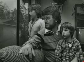
Kristen, Dave and Ambrose Hunt looking out their window
https://search.heritageburnaby.ca/link/archivedescription59063
- Repository
- City of Burnaby Archives
- Date
- ca.1983
- Collection/Fonds
- Columbian Newspaper collection
- Description Level
- Item
- Physical Description
- 1 photograph : b&w ; 19.5 x 25.5 cm
- Scope and Content
- Photograph of a man with two children, looking out the window of their home.
- Repository
- City of Burnaby Archives
- Date
- ca.1983
- Collection/Fonds
- Columbian Newspaper collection
- Physical Description
- 1 photograph : b&w ; 19.5 x 25.5 cm
- Description Level
- Item
- Record No.
- 480-1469
- Access Restriction
- No restrictions
- Reproduction Restriction
- Reproduce for fair dealing purposes only
- Accession Number
- 2009-01
- Scope and Content
- Photograph of a man with two children, looking out the window of their home.
- Media Type
- Photograph
- Photographer
- Battistoni, Peter
- Notes
- Title based on contents of photograph
- Note on recto reads: "Kristen, Dave, Ambrose Hunt"
- Photographer's stamp on verso
- Note on verso reads: "27 Oct / Burnaby / Today / PMT 100%"
Images

6113 Silver Avenue lot
https://search.heritageburnaby.ca/link/archivedescription37775
- Repository
- City of Burnaby Archives
- Date
- 1986 (date of original), copied 1991
- Collection/Fonds
- Burnaby Historical Society fonds
- Description Level
- Item
- Physical Description
- 1 photograph : b&w ; 3.1 x 4.4 cm print on contact sheet 20.3 x 26.2 cm
- Scope and Content
- Photograph of the lot at 6113 Silver Avenue, the former home of the Ellis family. The house has been demolished and an empty lot remains. Houses, aparment buildings, and the Expo line skytrain track with cars on it can be seen in the background.
- Repository
- City of Burnaby Archives
- Date
- 1986 (date of original), copied 1991
- Collection/Fonds
- Burnaby Historical Society fonds
- Subseries
- Burnaby Image Bank subseries
- Physical Description
- 1 photograph : b&w ; 3.1 x 4.4 cm print on contact sheet 20.3 x 26.2 cm
- Description Level
- Item
- Record No.
- 370-363
- Access Restriction
- No restrictions
- Reproduction Restriction
- No restrictions
- Accession Number
- BHS1999-03
- Scope and Content
- Photograph of the lot at 6113 Silver Avenue, the former home of the Ellis family. The house has been demolished and an empty lot remains. Houses, aparment buildings, and the Expo line skytrain track with cars on it can be seen in the background.
- Subjects
- Land Clearing
- Media Type
- Photograph
- Notes
- Title based on contents of photograph
- 1 b&w copy negative accompanying
- Negative has a pink cast
- Copied from col. photograph
- Geographic Access
- Silver Avenue
- Street Address
- 6113 Silver Avenue
- Historic Neighbourhood
- Central Park (Historic Neighbourhood)
- Planning Study Area
- Maywood Area
Images

8855 Northbrook Court
https://search.heritageburnaby.ca/link/archivedescription93735
- Repository
- City of Burnaby Archives
- Date
- 1989
- Collection/Fonds
- Grover, Elliott & Co. Ltd. fonds
- Description Level
- File
- Physical Description
- 21 photographs : col. negatives ; 35 mm
- Scope and Content
- Photographs of an undeveloped property loacated at 8855 Northbrook Court. Construction equipment is visible in the distance.
- Repository
- City of Burnaby Archives
- Date
- 1989
- Collection/Fonds
- Grover, Elliott & Co. Ltd. fonds
- Physical Description
- 21 photographs : col. negatives ; 35 mm
- Description Level
- File
- Record No.
- 622-020
- Access Restriction
- No restrictions
- Reproduction Restriction
- No restrictions
- Accession Number
- 2017-39
- Scope and Content
- Photographs of an undeveloped property loacated at 8855 Northbrook Court. Construction equipment is visible in the distance.
- Media Type
- Photograph
- Notes
- Transcribed title
- Title transcribed from original print envelope
- File no. 89-037-B
- Geographic Access
- Northbrook Court
- Street Address
- 8855 Northbrook Court
- Historic Neighbourhood
- Fraser Arm (Historic Neighbourhood)
- Planning Study Area
- Big Bend Area

Alfred Bingham's writings - Track 1
https://search.heritageburnaby.ca/link/oralhistory251
- Repository
- City of Burnaby Archives
- Date Range
- 1865-1919
- Length
- 0:10:18
- Summary
- This portion of the recording includes Alfred Bingham's essay entitled Stump Rangers, a listing of early settlers that includes addresses and short descriptions, essays on Confederation Park, land clearing and on Burnaby's first Council meeting.
- Repository
- City of Burnaby Archives
- Summary
- This portion of the recording includes Alfred Bingham's essay entitled Stump Rangers, a listing of early settlers that includes addresses and short descriptions, essays on Confederation Park, land clearing and on Burnaby's first Council meeting.
- Date Range
- 1865-1919
- Photo Info
- Alfred Bingham, April 20, 1947. Item no. 010-066
- Length
- 0:10:18
- Scope and Content
- Recording is of Alfred Bingham's writings, as read by Alfred Bingham. Major themes discussed are: Pioneers, early days in Burnaby and the Co-op Movement. To view "Narrow By" terms for each track expand this description and see "Notes".
- Biographical Notes
- Alfred "Alf" Bingham was born in England in 1892 and moved to Canada in 1912. His first job in Canada was laying track for the Grand Trunk Pacific Railway (GTPR) from Edmonton to McBride in 1912. His second was in Vancouver at the Rat Portage Mill on False Creek, working on the Resaw machine. He quit after one week due to poor working conditions. After taking part in the 1919 Winnipeg General Strike as a delegate of the Retail and Mailorder Union (A.F.L.) on the Winnipeg Trades and Labour Council, Alfred moved to Burnaby where he and fellow Burnaby residents Aungus McLean and Percy Little worked ten hour days to build a Shingle Mill on the edge of Burnaby Lake for Simpson & Giberson. George Green, carpenter and millwright (author of “The History of Burnaby”) also helped in the construction of the mill. Alfred built his own home from lumber cut from the mill in the Lochdale area on Sherlock Street between Curtis Street and Kitchener Street. On April 10, 1920 Alfred married Mary Jane “Ada” Reynolds. Alfred and Ada often took in foster children during their marriage. Due to her nursing experience, Ada was often called upon to deliver babies in the Burnaby area. Alfred and Ada Bingham were instrumental members of the Army of the Common Good, collecting vegetables and grains from growers in the area and even producing over 125 tons of vegetables from its own gardens to feed children and youth suffering from the lack of resources during the Depression years. The army was in operation for ten years and during that time the members organised the Credit Union movement of British Columbia and drew up the Credit Union act thorough the Vancouver Co-operative Council. They also started Co-Op stores and the Co-Op Wholesale Society. Alfred was also Secretary of the Burnaby Housing committee and in 1946 he became the Secretary of the North Burnaby Labour Progressive Party (LPP). Mary Jane “Ada” (Reynolds) Bingham died on August 9, 1969. Her husband Alfred died on April 29, 1979.
- Total Tracks
- 12
- Total Length
- 1:38:06
- Interviewee Name
- Bingham, Alfred "Alf"
- Collection/Fonds
- Burnaby Historical Society fonds
- Subseries
- Oral history subseries
- Transcript Available
- MSS142-001 contains transcripts for each of the short stories
- Media Type
- Sound Recording
- Web Notes
- Interview was digitized in 2010 allowing it to be accessible on Heritage Burnaby. The digitization project was initiated by the Community Heritage Commission with support from City of Burnaby Council and the BC History Digitization Program of the Irving K. Barber Learning Centre, University of British Columbia. It was recognized by the Heritage Society of BC with an award in 2012.
Images

Audio Tracks
Track one of recording of Alfred Bingham's writings
Track one of recording of Alfred Bingham's writings
https://search.heritageburnaby.ca/media/hpo/_Data/_Archives_Oral_Histories/_Unrestricted/100-13-20-2/100-13-20-2_Track_1.mp3
Alfred Bingham's writings - Track 3
https://search.heritageburnaby.ca/link/oralhistory253
- Repository
- City of Burnaby Archives
- Date Range
- 1903-1940
- Length
- 0:09:46
- Summary
- This portion of the recording includes Alfred Bingham's descriptions of road construction in Burnaby, including the names of the settlers and logging companies involved in their construction. Alfred discusses the changes that took place during World War I, along with municipal Relief work that he t…
- Repository
- City of Burnaby Archives
- Summary
- This portion of the recording includes Alfred Bingham's descriptions of road construction in Burnaby, including the names of the settlers and logging companies involved in their construction. Alfred discusses the changes that took place during World War I, along with municipal Relief work that he took part in at Burnaby Mountain. Alfred also discusses early schools and mentions his wife, Ada Bingham.
- Date Range
- 1903-1940
- Photo Info
- Alfred Bingham, April 20, 1947. Item no. 010-066
- Length
- 0:09:46
- Planning Study Area
- Burnaby Mountain Area
- Scope and Content
- Recording is of Alfred Bingham's writings, as read by Alfred Bingham. Major themes discussed are: Pioneers, early days in Burnaby and the Co-op Movement. To view "Narrow By" terms for each track expand this description and see "Notes".
- Biographical Notes
- Alfred "Alf" Bingham was born in England in 1892 and moved to Canada in 1912. His first job in Canada was laying track for the Grand Trunk Pacific Railway (GTPR) from Edmonton to McBride in 1912. His second was in Vancouver at the Rat Portage Mill on False Creek, working on the Resaw machine. He quit after one week due to poor working conditions. After taking part in the 1919 Winnipeg General Strike as a delegate of the Retail and Mailorder Union (A.F.L.) on the Winnipeg Trades and Labour Council, Alfred moved to Burnaby where he and fellow Burnaby residents Aungus McLean and Percy Little worked ten hour days to build a Shingle Mill on the edge of Burnaby Lake for Simpson & Giberson. George Green, carpenter and millwright (author of “The History of Burnaby”) also helped in the construction of the mill. Alfred built his own home from lumber cut from the mill in the Lochdale area on Sherlock Street between Curtis Street and Kitchener Street. On April 10, 1920 Alfred married Mary Jane “Ada” Reynolds. Alfred and Ada often took in foster children during their marriage. Due to her nursing experience, Ada was often called upon to deliver babies in the Burnaby area. Alfred and Ada Bingham were instrumental members of the Army of the Common Good, collecting vegetables and grains from growers in the area and even producing over 125 tons of vegetables from its own gardens to feed children and youth suffering from the lack of resources during the Depression years. The army was in operation for ten years and during that time the members organised the Credit Union movement of British Columbia and drew up the Credit Union act thorough the Vancouver Co-operative Council. They also started Co-Op stores and the Co-Op Wholesale Society. Alfred was also Secretary of the Burnaby Housing committee and in 1946 he became the Secretary of the North Burnaby Labour Progressive Party (LPP). Mary Jane “Ada” (Reynolds) Bingham died on August 9, 1969. Her husband Alfred died on April 29, 1979.
- Total Tracks
- 12
- Total Length
- 1:38:06
- Interviewee Name
- Bingham, Alfred "Alf"
- Collection/Fonds
- Burnaby Historical Society fonds
- Subseries
- Oral history subseries
- Transcript Available
- MSS142-001 contains transcripts for each of the short stories
- Media Type
- Sound Recording
- Web Notes
- Interview was digitized in 2010 allowing it to be accessible on Heritage Burnaby. The digitization project was initiated by the Community Heritage Commission with support from City of Burnaby Council and the BC History Digitization Program of the Irving K. Barber Learning Centre, University of British Columbia. It was recognized by the Heritage Society of BC with an award in 2012.
Images
Audio Tracks
Track three of recording of Alfred Bingham's writings
Track three of recording of Alfred Bingham's writings
https://search.heritageburnaby.ca/media/hpo/_Data/_Archives_Oral_Histories/_Unrestricted/100-13-20-2/100-13-20-2_Track_3.mp3
Barnet Wagon Road
https://search.heritageburnaby.ca/link/archivedescription38306
- Repository
- City of Burnaby Archives
- Date
- June 1903 (date of original), copied ca. 1990
- Collection/Fonds
- Burnaby Historical Society fonds
- Description Level
- Item
- Physical Description
- 1 photograph : b&w ; 10 x 15 cm print
- Scope and Content
- Photograph of the Barnet Wagon Road looking west from Sperling Avenue.
- Repository
- City of Burnaby Archives
- Date
- June 1903 (date of original), copied ca. 1990
- Collection/Fonds
- Burnaby Historical Society fonds
- Subseries
- Photographs subseries
- Physical Description
- 1 photograph : b&w ; 10 x 15 cm print
- Description Level
- Item
- Record No.
- 403-001
- Access Restriction
- No restrictions
- Reproduction Restriction
- No known restrictions
- Accession Number
- BHS2007-04
- Scope and Content
- Photograph of the Barnet Wagon Road looking west from Sperling Avenue.
- Subjects
- Land Clearing
- Geographic Features - Roads
- Media Type
- Photograph
- Notes
- Title based on contents of photograph
- Geographic Access
- Barnet Road
- Sperling Avenue
- Historic Neighbourhood
- Lochdale (Historic Neighbourhood)
- Planning Study Area
- Westridge Area
Images


Barnet Wagon Road
https://search.heritageburnaby.ca/link/archivedescription38307
- Repository
- City of Burnaby Archives
- Date
- June 1903 (date of original), copied ca. 1990
- Collection/Fonds
- Burnaby Historical Society fonds
- Description Level
- Item
- Physical Description
- 1 photograph : b&w ; 10 x 15 cm print
- Scope and Content
- Photograph of the Barnet Wagon Road looking east, near Barnet and Hastings.
- Repository
- City of Burnaby Archives
- Date
- June 1903 (date of original), copied ca. 1990
- Collection/Fonds
- Burnaby Historical Society fonds
- Subseries
- Photographs subseries
- Physical Description
- 1 photograph : b&w ; 10 x 15 cm print
- Description Level
- Item
- Record No.
- 403-002
- Access Restriction
- No restrictions
- Reproduction Restriction
- No known restrictions
- Accession Number
- BHS2007-04
- Scope and Content
- Photograph of the Barnet Wagon Road looking east, near Barnet and Hastings.
- Subjects
- Land Clearing
- Geographic Features - Roads
- Media Type
- Photograph
- Notes
- Title based on contents of photograph
- Geographic Access
- Barnet Road
- Hastings Street
- Historic Neighbourhood
- Lochdale (Historic Neighbourhood)
- Planning Study Area
- Westridge Area
Images


Claude Hill beside a large felled tree
https://search.heritageburnaby.ca/link/archivedescription39517
- Repository
- City of Burnaby Archives
- Date
- 1900
- Collection/Fonds
- Peers Family and Hill Family fonds
- Description Level
- Item
- Physical Description
- 1 photograph : b&w ; 10.5 x 15 cm on page 21.5 x 28 cm (pasted in album)
- Scope and Content
- Photograph of Louis Claude Hill standing by a ladder placed in a ditch. The ladder is leaning against a giant tree upturned by the roots. The ditch appears to be created from uprooting the tree. There is a pile of firewood visible to the right, and a barn to the left in the distance.
- Repository
- City of Burnaby Archives
- Date
- 1900
- Collection/Fonds
- Peers Family and Hill Family fonds
- Physical Description
- 1 photograph : b&w ; 10.5 x 15 cm on page 21.5 x 28 cm (pasted in album)
- Description Level
- Item
- Record No.
- 477-836
- Access Restriction
- No restrictions
- Reproduction Restriction
- No known restrictions
- Accession Number
- 2007-12
- Scope and Content
- Photograph of Louis Claude Hill standing by a ladder placed in a ditch. The ladder is leaning against a giant tree upturned by the roots. The ditch appears to be created from uprooting the tree. There is a pile of firewood visible to the right, and a barn to the left in the distance.
- Subjects
- Land Clearing
- Plants - Trees
- Media Type
- Photograph
- Notes
- Title based on contents of photograph
- Geographic Access
- Deer Lake Avenue
- Historic Neighbourhood
- Burnaby Lake (Historic Neighbourhood)
Images

, copied 1978 thumbnail](/media/hpo/_Data/_BVM_Images/1977/197800010016.jpg?width=280)
Cleared land
https://search.heritageburnaby.ca/link/museumdescription462
- Repository
- Burnaby Village Museum
- Date
- [190-](date of original), copied 1978
- Collection/Fonds
- Burnaby Village Museum Photograph collection
- Description Level
- Item
- Physical Description
- 1 photograph : b&w ; 20.2 x 25.2 cm print
- Scope and Content
- Photograph of the cleared land which appears to be the Sprott family property. There are stumps and felled trees on the lot. Across a small dirt road and behind a wooden fence, the Haszard house is visible to the extreme right of the photograph.
- Repository
- Burnaby Village Museum
- Collection/Fonds
- Burnaby Village Museum Photograph collection
- Description Level
- Item
- Physical Description
- 1 photograph : b&w ; 20.2 x 25.2 cm print
- Scope and Content
- Photograph of the cleared land which appears to be the Sprott family property. There are stumps and felled trees on the lot. Across a small dirt road and behind a wooden fence, the Haszard house is visible to the extreme right of the photograph.
- Subjects
- Land Clearing
- Plants - Trees
- Geographic Access
- Canada Way
- Accession Code
- HV978.1.16
- Access Restriction
- No restrictions
- Reproduction Restriction
- No known restrictions
- Date
- [190-](date of original), copied 1978
- Media Type
- Photograph
- Historic Neighbourhood
- Burnaby Lake (Historic Neighbourhood)
- Scan Resolution
- 600
- Scan Date
- 2023-08-01
- Notes
- Title based on contents of photograph
Images
, copied 1978 thumbnail](/media/hpo/_Data/_BVM_Images/1977/197800010016.jpg)

Former site of the Kelly Douglas building
https://search.heritageburnaby.ca/link/archivedescription35027
- Repository
- City of Burnaby Archives
- Date
- August 18, 1986
- Collection/Fonds
- Burnaby Historical Society fonds
- Description Level
- Item
- Physical Description
- 1 photograph : col. ; 8.8 x 12.6 cm
- Scope and Content
- Photograph of the site of Kelly Douglas and Co. at 4700 Kingsway after the building was demolished. A bulldozer and a large truck with two men standing on it are at the back left of the photograph.
- Repository
- City of Burnaby Archives
- Date
- August 18, 1986
- Collection/Fonds
- Burnaby Historical Society fonds
- Subseries
- Evelyn Salisbury subseries
- Physical Description
- 1 photograph : col. ; 8.8 x 12.6 cm
- Material Details
- Printed on verso of photograph: "This paper manufactured by Kodak"
- Description Level
- Item
- Record No.
- 178-001
- Access Restriction
- No restrictions
- Reproduction Restriction
- Reproduce for fair dealing purposes only
- Accession Number
- BHS1986-26
- Scope and Content
- Photograph of the site of Kelly Douglas and Co. at 4700 Kingsway after the building was demolished. A bulldozer and a large truck with two men standing on it are at the back left of the photograph.
- Media Type
- Photograph
- Notes
- Title based on contents of photograph
- Geographic Access
- Kingsway
- Street Address
- 4700 Kingsway
- Historic Neighbourhood
- Central Park (Historic Neighbourhood)
- Planning Study Area
- Maywood Area
Images
