Narrow Results By
Format
- Architectural Drawing 218
- Cartographic Material 109
- Council - Committee Report 5194
- Council - Manager's Report 6978
- Council - Mayor/Councillor/Staff Report 9646
- Council - Public Hearing Minutes 160
- Council - Regular Council Minutes 1845
- Graphic Material 23
- Moving Images 14
- Photograph
- Sound Recording
- Technical Drawing 3
Decade
- 2020s 85
- 2010s 172
- 2000s 1859
- 1990s 2556
- 1980s
- 1970s 2179
- 1960s 1187
- 1950s
- 1940s 1398
- 1930s 1307
- 1920s 1725
- 1910s
- 1900s
- 1890s
- 1880s
- 1870s
- 1860s 114
- 1850s 11
- 1840s 5
- 1830s 4
- 1820s 4
- 1810s 3
- 1800s 3
- 1790s 2
- 1780s 2
- 1770s 2
- 1760s 2
- 1750s 2
- 1740s 2
- 1730s 2
- 1720s 2
- 1710s 2
- 1700s 2
- 1690s 2
- 1680s 2
- 1670s 1
- 1660s 1
- 1650s 1
- 1640s 1
- 1630s 1
- 1620s 1
- 1610s 1
- 1600s 1
- 1590s 1
- 1580s 1
- 1570s 1
- 1560s 1
- 1550s 1
- 1540s 1
- 1530s 1
- 1520s 1
- 1510s 1
- 1500s 1
- 1490s 1
- 1480s 1
Subject
- Accidents - Automobile Accidents 2
- Adornment - Jewelry 2
- Advertising Medium 6
- Advertising Medium - Signs and Signboards 21
- Aerial Photographs 25
- Agricultural Tools and Equipment 10
- Agricultural Tools and Equipment - Gardening Equipment 4
- Agricultural Tools and Equipment - Plows 3
- Agriculture 4
- Agriculture - Crops 16
- Agriculture - Farms 57
- Agriculture - Fruit and Berries 18

1982 - Moving the Roberts House
https://search.heritageburnaby.ca/link/archivedescription91890
- Repository
- City of Burnaby Archives
- Date
- November 1982
- Collection/Fonds
- Small family fonds
- Description Level
- Item
- Physical Description
- 1 photograph : col. ; 9 cm x 13 cm
- Scope and Content
- Photograph of the Roberts' house in its new position at 5496 Dominion Street. Cedar siding was added to finish the exterior, the original white pillars were re-installed on the front porch, the house was stained, and basic landscaping was completed.
- Repository
- City of Burnaby Archives
- Date
- November 1982
- Collection/Fonds
- Small family fonds
- Physical Description
- 1 photograph : col. ; 9 cm x 13 cm
- Description Level
- Item
- Record No.
- 620-071
- Access Restriction
- No restrictions
- Reproduction Restriction
- No reproduction permitted
- Accession Number
- 2017-01
- Scope and Content
- Photograph of the Roberts' house in its new position at 5496 Dominion Street. Cedar siding was added to finish the exterior, the original white pillars were re-installed on the front porch, the house was stained, and basic landscaping was completed.
- Media Type
- Photograph
- Notes
- Transcribed title
- Title transcribed from donor's notes
- Note in blue ink on verso of photograph reads: "B19 P13"
- Note in pencil on verso of photograph reads: "12"
- Note in black ink on verso of photograph reads: "Front Steps Now! and A New Staining Job. / Nov. 1982"
- Street Address
- 5496 Dominion Street
- Historic Neighbourhood
- Burnaby Lake (Historic Neighbourhood)
- Planning Study Area
- Ardingley-Sprott Area
Images


1982 - Moving the Roberts House
https://search.heritageburnaby.ca/link/archivedescription91891
- Repository
- City of Burnaby Archives
- Date
- 1982
- Collection/Fonds
- Small family fonds
- Description Level
- Item
- Physical Description
- 1 photograph : col. ; 10 cm x 15 cm
- Scope and Content
- Photograph of an excavator clearing the land between 5496 Dominion Street and Douglas Road. The three lots in this area were subdivided into six 33 foot lots and cleared for the construction of six new houses.
- Repository
- City of Burnaby Archives
- Date
- 1982
- Collection/Fonds
- Small family fonds
- Physical Description
- 1 photograph : col. ; 10 cm x 15 cm
- Description Level
- Item
- Record No.
- 620-072
- Access Restriction
- No restrictions
- Reproduction Restriction
- No reproduction permitted
- Accession Number
- 2017-01
- Scope and Content
- Photograph of an excavator clearing the land between 5496 Dominion Street and Douglas Road. The three lots in this area were subdivided into six 33 foot lots and cleared for the construction of six new houses.
- Media Type
- Photograph
- Notes
- Transcribed title
- Title transcribed from donor's notes
- Note in blue ink on verso of photograph reads: "P.14"
- Note in pencil on verso of photograph reads: "13"
- Street Address
- 5496 Dominion Street
- Historic Neighbourhood
- Burnaby Lake (Historic Neighbourhood)
- Planning Study Area
- Ardingley-Sprott Area
Images


1982 - Moving the Roberts House
https://search.heritageburnaby.ca/link/archivedescription91892
- Repository
- City of Burnaby Archives
- Date
- 1982
- Collection/Fonds
- Small family fonds
- Description Level
- Item
- Physical Description
- 1 photograph : col. ; 15 cm x 10 cm
- Scope and Content
- Photograph of a labourer removing the old foundation and boulders from the 5496 Dominion Street property with a jackhammer. The house located at 5511 Norfolk Street is visible in the background.
- Repository
- City of Burnaby Archives
- Date
- 1982
- Collection/Fonds
- Small family fonds
- Physical Description
- 1 photograph : col. ; 15 cm x 10 cm
- Description Level
- Item
- Record No.
- 620-073
- Access Restriction
- No restrictions
- Reproduction Restriction
- No reproduction permitted
- Accession Number
- 2017-01
- Scope and Content
- Photograph of a labourer removing the old foundation and boulders from the 5496 Dominion Street property with a jackhammer. The house located at 5511 Norfolk Street is visible in the background.
- Media Type
- Photograph
- Notes
- Transcribed title
- Title transcribed from donor's notes
- Note in blue ink on verso of photograph reads: "P.15"
- Note in pencil on verso of photograph reads: "14"
- 5511 Norfolk Street was previously numbered 3149 Norfolk Street. It was later subdivided into two lots: 5503 and 5521 Norfolk Street.
- Street Address
- 5511 Norfolk Street
- 5496 Dominion Street
- Historic Neighbourhood
- Burnaby Lake (Historic Neighbourhood)
- Planning Study Area
- Ardingley-Sprott Area
Images


1982 - Moving the Roberts House
https://search.heritageburnaby.ca/link/archivedescription91893
- Repository
- City of Burnaby Archives
- Date
- 1982 (date of original), copied 2017
- Collection/Fonds
- Small family fonds
- Description Level
- Item
- Physical Description
- 1 photograph : col. copy print ; 10 cm x 15 cm
- Scope and Content
- Photograph of new houses being constructed on the 33 foot lots between 5496 Dominion Street and Douglas Road. Framing is complete and the houses' roofs and windows are installed.
- Repository
- City of Burnaby Archives
- Date
- 1982 (date of original), copied 2017
- Collection/Fonds
- Small family fonds
- Physical Description
- 1 photograph : col. copy print ; 10 cm x 15 cm
- Description Level
- Item
- Record No.
- 620-074
- Access Restriction
- No restrictions
- Reproduction Restriction
- No reproduction permitted
- Accession Number
- 2017-01
- Scope and Content
- Photograph of new houses being constructed on the 33 foot lots between 5496 Dominion Street and Douglas Road. Framing is complete and the houses' roofs and windows are installed.
- Media Type
- Photograph
- Notes
- Transcribed title
- Title transcribed from donor's notes
- Note in blue ink on verso of photograph reads: "P.16"
- Geographic Access
- Dominion Street
- Street Address
- 5496 Dominion Street
- Historic Neighbourhood
- Burnaby Lake (Historic Neighbourhood)
- Planning Study Area
- Ardingley-Sprott Area
Images


1982 - Moving the Roberts House 5538 Dominion Street to its new location at 5496 Dominion Street
https://search.heritageburnaby.ca/link/archivedescription91879
- Repository
- City of Burnaby Archives
- Date
- 1982
- Collection/Fonds
- Small family fonds
- Description Level
- Item
- Physical Description
- 1 photograph : col. ; 9 cm x 13 cm
- Scope and Content
- Photograph of the site at 5496 Dominion Street where the Roberts' house was to be moved. To the left is the old garage that was originally part of the small dwelling the Roberts lived in during the construction of their house in the early 1920s. In the background is 3093 Douglas Road and in the f…
- Repository
- City of Burnaby Archives
- Date
- 1982
- Collection/Fonds
- Small family fonds
- Physical Description
- 1 photograph : col. ; 9 cm x 13 cm
- Description Level
- Item
- Record No.
- 620-060
- Access Restriction
- No restrictions
- Reproduction Restriction
- No reproduction permitted
- Accession Number
- 2017-01
- Scope and Content
- Photograph of the site at 5496 Dominion Street where the Roberts' house was to be moved. To the left is the old garage that was originally part of the small dwelling the Roberts lived in during the construction of their house in the early 1920s. In the background is 3093 Douglas Road and in the foreground are two apple trees planted by John W. Roberts.
- Media Type
- Photograph
- Notes
- Transcribed title
- Title transcribed from donor's notes
- Note in blue ink on verso of photograph reads: "p.2"
- Note in blue ink on verso of photograph reads: "Garage, Poplar Tree and Apple Trees before they had to go to make room to move house here / Spring 1982"
- 5118 Douglas Road renumbered to 3131 Douglas Road in 1958 and to 5538 Dominion Street in 1970 or 1971
- Street Address
- 5496 Dominion Street
- Historic Neighbourhood
- Burnaby Lake (Historic Neighbourhood)
- Planning Study Area
- Ardingley-Sprott Area
Images

![2924 Silver Avenue, [1954] (date of original), copied 1991 thumbnail](/media/hpo/_Data/_Archives_Images/_Unrestricted/370/370-340.jpg?width=280)
2924 Silver Avenue
https://search.heritageburnaby.ca/link/archivedescription37752
- Repository
- City of Burnaby Archives
- Date
- [1954] (date of original), copied 1991
- Collection/Fonds
- Burnaby Historical Society fonds
- Description Level
- Item
- Physical Description
- 1 photograph : b&w ; 2.5 x 3.9 cm print on contact sheet 20.5 x 26.4 cm
- Scope and Content
- Photograph of the completed addition to 2924 Silver Avenue (later renumbered 6113 Silver Avenue).
- Repository
- City of Burnaby Archives
- Date
- [1954] (date of original), copied 1991
- Collection/Fonds
- Burnaby Historical Society fonds
- Subseries
- Burnaby Image Bank subseries
- Physical Description
- 1 photograph : b&w ; 2.5 x 3.9 cm print on contact sheet 20.5 x 26.4 cm
- Description Level
- Item
- Record No.
- 370-340
- Access Restriction
- No restrictions
- Reproduction Restriction
- No restrictions
- Accession Number
- BHS1999-03
- Scope and Content
- Photograph of the completed addition to 2924 Silver Avenue (later renumbered 6113 Silver Avenue).
- Subjects
- Buildings - Residential - Houses
- Media Type
- Photograph
- Notes
- Title based on contents of photograph
- 1 b&w copy negative accompanying
- Negative has a pink cast
- Geographic Access
- Silver Avenue
- Street Address
- 6113 Silver Avenue
- Historic Neighbourhood
- Central Park (Historic Neighbourhood)
- Planning Study Area
- Maywood Area
Images
![2924 Silver Avenue, [1954] (date of original), copied 1991 thumbnail](/media/hpo/_Data/_Archives_Images/_Unrestricted/370/370-340.jpg)

2924 Silver Avenue
https://search.heritageburnaby.ca/link/archivedescription37753
- Repository
- City of Burnaby Archives
- Date
- June 1954 (date of original), copied 1991
- Collection/Fonds
- Burnaby Historical Society fonds
- Description Level
- Item
- Physical Description
- 1 photograph : b&w ; 2.6 x 3.9 cm print on contact sheet 20.5 x 26.4 cm
- Scope and Content
- Photograph of the construction of an addition to 2924 Silver Avenue (later renumbered 6113 Silver Avenue). Three people are on the roof of the house, and two others are on a ladder.
- Repository
- City of Burnaby Archives
- Date
- June 1954 (date of original), copied 1991
- Collection/Fonds
- Burnaby Historical Society fonds
- Subseries
- Burnaby Image Bank subseries
- Physical Description
- 1 photograph : b&w ; 2.6 x 3.9 cm print on contact sheet 20.5 x 26.4 cm
- Description Level
- Item
- Record No.
- 370-341
- Access Restriction
- No restrictions
- Reproduction Restriction
- No restrictions
- Accession Number
- BHS1999-03
- Scope and Content
- Photograph of the construction of an addition to 2924 Silver Avenue (later renumbered 6113 Silver Avenue). Three people are on the roof of the house, and two others are on a ladder.
- Media Type
- Photograph
- Notes
- Title based on contents of photograph
- 1 b&w copy negative accompanying
- Negative has a pink cast
- Geographic Access
- Silver Avenue
- Street Address
- 6113 Silver Avenue
- Historic Neighbourhood
- Central Park (Historic Neighbourhood)
- Planning Study Area
- Maywood Area
Images

3000, 3100, 3200 Beta Ave
https://search.heritageburnaby.ca/link/archivedescription93739
- Repository
- City of Burnaby Archives
- Date
- 1989
- Collection/Fonds
- Grover, Elliott & Co. Ltd. fonds
- Description Level
- File
- Physical Description
- 40 photographs : col. negatives ; 35 mm
- Scope and Content
- Photographs of the commercial buildings and loading bays located at 3000, 3100, and 3200 Beta Avenue.
- Repository
- City of Burnaby Archives
- Date
- 1989
- Collection/Fonds
- Grover, Elliott & Co. Ltd. fonds
- Physical Description
- 40 photographs : col. negatives ; 35 mm
- Description Level
- File
- Record No.
- 622-024
- Access Restriction
- No restrictions
- Reproduction Restriction
- No restrictions
- Accession Number
- 2017-39
- Scope and Content
- Photographs of the commercial buildings and loading bays located at 3000, 3100, and 3200 Beta Avenue.
- Subjects
- Buildings - Commercial
- Media Type
- Photograph
- Notes
- Transcribed title
- Title transcribed from print envelope photographs were originally housed in
- File no. 89-214-B
- Geographic Access
- Beta Avenue
- Street Address
- 3000 Beta Avenue
- 3100 Beta Avenue
- 3200 Beta Avenue
- Planning Study Area
- Douglas-Gilpin Area
3051-75 Underhill Ave
https://search.heritageburnaby.ca/link/archivedescription93744
- Repository
- City of Burnaby Archives
- Date
- 1989
- Collection/Fonds
- Grover, Elliott & Co. Ltd. fonds
- Description Level
- File
- Physical Description
- 11 photographs : col. negatives ; 35 mm
- Scope and Content
- Photographs of two industrial buildings and a residential building in Burnaby, BC.
- Repository
- City of Burnaby Archives
- Date
- 1989
- Collection/Fonds
- Grover, Elliott & Co. Ltd. fonds
- Physical Description
- 11 photographs : col. negatives ; 35 mm
- Description Level
- File
- Record No.
- 622-029
- Access Restriction
- No restrictions
- Reproduction Restriction
- No restrictions
- Accession Number
- 2017-39
- Scope and Content
- Photographs of two industrial buildings and a residential building in Burnaby, BC.
- Media Type
- Photograph
- Notes
- Transcribed title
- Title transcribed from print envelope photographs were originally housed in
- File no. 89-394-B
- Geographic Access
- Underhill Avenue
- Planning Study Area
- Lake City Area
3650 Bonneville Place
https://search.heritageburnaby.ca/link/archivedescription93737
- Repository
- City of Burnaby Archives
- Date
- March 1989
- Collection/Fonds
- Grover, Elliott & Co. Ltd. fonds
- Description Level
- File
- Physical Description
- 8 photographs : col. ; 10 cm x 15 cm
- Scope and Content
- Photographs of the commercial complex located at 3650 Bonneville Place. Phase I of the complex is complete and Phase II is under construction. Businesses visible in the photographs include Four Seasons Greenhouses and Shaw.
- Repository
- City of Burnaby Archives
- Date
- March 1989
- Collection/Fonds
- Grover, Elliott & Co. Ltd. fonds
- Physical Description
- 8 photographs : col. ; 10 cm x 15 cm
- Description Level
- File
- Record No.
- 622-022
- Access Restriction
- No restrictions
- Reproduction Restriction
- No restrictions
- Accession Number
- 2017-39
- Scope and Content
- Photographs of the commercial complex located at 3650 Bonneville Place. Phase I of the complex is complete and Phase II is under construction. Businesses visible in the photographs include Four Seasons Greenhouses and Shaw.
- Subjects
- Buildings - Commercial
- Construction
- Media Type
- Photograph
- Notes
- Transcribed title
- Title transcribed from sticky note adhered to photograph 622-022-1
- File no. 89-124-B
- Photograph 622-022-1 captions reads: "3650 Bonneville - south view"
- Photograph 622-022-2 caption reads: "North and east facade"
- Photograph 622-022-3 caption reads: "View north along Broadway Street; Note entry bridges"
- Photograph 622-022-4 caption reads: "Southern view along Broadway Street"
- Photograph 622-022-5 caption reads: "Front facade and main entry for Phase I"
- Photograph 622-022-6 caption reads: "Rear and loading facilities for Phase I"
- Photograph 622-022-7 caption reads: "View west to Phase II from entry driveway"
- Photograph 622-022-8 caption reads: "Site preparation for Phase I
- Photograph captions transcribed from the paper on which the photographs were originally adhered.
- Geographic Access
- Bonneville Place
- Street Address
- 3650 Bonneville Place
- Planning Study Area
- Lake City Area
![3900 Block Union Street, [between 1912 and 1915] (date of original), copied 1991 thumbnail](/media/hpo/_Data/_Archives_Images/_Unrestricted/370/370-772.jpg?width=280)
3900 Block Union Street
https://search.heritageburnaby.ca/link/archivedescription38185
- Repository
- City of Burnaby Archives
- Date
- [between 1912 and 1915] (date of original), copied 1991
- Collection/Fonds
- Burnaby Historical Society fonds
- Description Level
- Item
- Physical Description
- 1 photograph : b&w ; 4.4 x 3.4 cm print on contact sheet 20.6 x 26.5 cm
- Scope and Content
- Photograph of the Spraggon family home and another house on the 3900 block of Union Street (formerly named Barnard Street). There is a child at play in the snow in the foreground.
- Repository
- City of Burnaby Archives
- Date
- [between 1912 and 1915] (date of original), copied 1991
- Collection/Fonds
- Burnaby Historical Society fonds
- Subseries
- Burnaby Image Bank subseries
- Physical Description
- 1 photograph : b&w ; 4.4 x 3.4 cm print on contact sheet 20.6 x 26.5 cm
- Description Level
- Item
- Record No.
- 370-772
- Access Restriction
- No restrictions
- Reproduction Restriction
- No known restrictions
- Accession Number
- BHS1999-03
- Scope and Content
- Photograph of the Spraggon family home and another house on the 3900 block of Union Street (formerly named Barnard Street). There is a child at play in the snow in the foreground.
- Media Type
- Photograph
- Notes
- Title based on contents of photograph
- 1 b&w copy negative accompanying
- Negative has a pink cast
- Geographic Access
- Union Street
- Historic Neighbourhood
- Vancouver Heights (Historic Neighbourhood)
- Planning Study Area
- Willingdon Heights Area
Images
![3900 Block Union Street, [between 1912 and 1915] (date of original), copied 1991 thumbnail](/media/hpo/_Data/_Archives_Images/_Unrestricted/370/370-772.jpg)
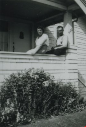
4123 Oxford Street
https://search.heritageburnaby.ca/link/archivedescription38197
- Repository
- City of Burnaby Archives
- Date
- 1953 (date of original), copied 1991
- Collection/Fonds
- Burnaby Historical Society fonds
- Description Level
- Item
- Physical Description
- 1 photograph : b&w ; 4.2 x 2.8 cm print on contact sheet 20.3 x 26.6 cm
- Scope and Content
- Photograph of a woman and a man sitting on the edge of the porch at 4123 Oxford Street.
- Repository
- City of Burnaby Archives
- Date
- 1953 (date of original), copied 1991
- Collection/Fonds
- Burnaby Historical Society fonds
- Subseries
- Burnaby Image Bank subseries
- Physical Description
- 1 photograph : b&w ; 4.2 x 2.8 cm print on contact sheet 20.3 x 26.6 cm
- Description Level
- Item
- Record No.
- 370-784
- Access Restriction
- No restrictions
- Reproduction Restriction
- No restrictions
- Accession Number
- BHS1999-03
- Scope and Content
- Photograph of a woman and a man sitting on the edge of the porch at 4123 Oxford Street.
- Media Type
- Photograph
- Notes
- Title based on contents of photograph
- 1 b&w copy negative accompanying
- Geographic Access
- Oxford Street
- Street Address
- 4123 Oxford Street
- Historic Neighbourhood
- Vancouver Heights (Historic Neighbourhood)
- Planning Study Area
- Burnaby Heights Area
Images


4297 Albert Street
https://search.heritageburnaby.ca/link/archivedescription37591
- Repository
- City of Burnaby Archives
- Date
- 1951 (date of original), copied 1991
- Collection/Fonds
- Burnaby Historical Society fonds
- Description Level
- Item
- Physical Description
- 1 photograph : b&w ; 2.7 x 4.2 cm print on contact sheet 20.2 x 25.3 cm
- Scope and Content
- Photograph of 4297 Albert Street. Another house is visible in the background.
- Repository
- City of Burnaby Archives
- Date
- 1951 (date of original), copied 1991
- Collection/Fonds
- Burnaby Historical Society fonds
- Subseries
- Burnaby Image Bank subseries
- Physical Description
- 1 photograph : b&w ; 2.7 x 4.2 cm print on contact sheet 20.2 x 25.3 cm
- Description Level
- Item
- Record No.
- 370-179
- Access Restriction
- No restrictions
- Reproduction Restriction
- No restrictions
- Accession Number
- BHS1999-03
- Scope and Content
- Photograph of 4297 Albert Street. Another house is visible in the background.
- Subjects
- Buildings - Residential - Houses
- Media Type
- Photograph
- Notes
- Title based on contents of photograph
- 1 b&w copy negative accompanying
- Negative has a pink cast
- Geographic Access
- Albert Street
- Street Address
- 4297 Albert Street
- Historic Neighbourhood
- Vancouver Heights (Historic Neighbourhood)
- Planning Study Area
- Burnaby Heights Area
Images


4297 Albert Street
https://search.heritageburnaby.ca/link/archivedescription37592
- Repository
- City of Burnaby Archives
- Date
- 1950 (date of original), copied 1991
- Collection/Fonds
- Burnaby Historical Society fonds
- Description Level
- Item
- Physical Description
- 1 photograph : b&w ; 3.4 x 3.5 cm print on contact sheet 20.2 x 25.3 cm
- Scope and Content
- Photograph of 4297 Albert Street.
- Repository
- City of Burnaby Archives
- Date
- 1950 (date of original), copied 1991
- Collection/Fonds
- Burnaby Historical Society fonds
- Subseries
- Burnaby Image Bank subseries
- Physical Description
- 1 photograph : b&w ; 3.4 x 3.5 cm print on contact sheet 20.2 x 25.3 cm
- Description Level
- Item
- Record No.
- 370-180
- Access Restriction
- No restrictions
- Reproduction Restriction
- No restrictions
- Accession Number
- BHS1999-03
- Scope and Content
- Photograph of 4297 Albert Street.
- Subjects
- Buildings - Residential - Houses
- Media Type
- Photograph
- Notes
- Title based on contents of photograph
- 1 b&w copy negative accompanying
- Negative has a pink cast
- Geographic Access
- Albert Street
- Street Address
- 4297 Albert Street
- Historic Neighbourhood
- Vancouver Heights (Historic Neighbourhood)
- Planning Study Area
- Burnaby Heights Area
Images

![4674 Southlawn Drive, [1958] (date of original), copied 1991 thumbnail](/media/hpo/_Data/_Archives_Images/_Unrestricted/370/370-461.jpg?width=280)
4674 Southlawn Drive
https://search.heritageburnaby.ca/link/archivedescription37873
- Repository
- City of Burnaby Archives
- Date
- [1958] (date of original), copied 1991
- Collection/Fonds
- Burnaby Historical Society fonds
- Description Level
- Item
- Physical Description
- 1 photograph : b&w ; 2.8 x 2.8 cm print on contact sheet 20.1 x 26.7 cm
- Scope and Content
- Photograph of 4674 Southlawn Drive in the snow. The snow-covered road can be seen in front of the house.
- Repository
- City of Burnaby Archives
- Date
- [1958] (date of original), copied 1991
- Collection/Fonds
- Burnaby Historical Society fonds
- Subseries
- Burnaby Image Bank subseries
- Physical Description
- 1 photograph : b&w ; 2.8 x 2.8 cm print on contact sheet 20.1 x 26.7 cm
- Description Level
- Item
- Record No.
- 370-461
- Access Restriction
- No restrictions
- Reproduction Restriction
- No restrictions
- Accession Number
- BHS1999-03
- Scope and Content
- Photograph of 4674 Southlawn Drive in the snow. The snow-covered road can be seen in front of the house.
- Media Type
- Photograph
- Notes
- Title based on contents of photograph
- 1 b&w copy negative accompanying
- Negative has a pink cast
- Geographic Access
- Southlawn Drive
- Street Address
- 4674 Southlawn Drive
- Planning Study Area
- Brentwood Area
Images
![4674 Southlawn Drive, [1958] (date of original), copied 1991 thumbnail](/media/hpo/_Data/_Archives_Images/_Unrestricted/370/370-461.jpg)
![4674 Southlawn Drive, [ca. 1954] (date of original), copied 1991 thumbnail](/media/hpo/_Data/_Archives_Images/_Unrestricted/370/370-462.jpg?width=280)
4674 Southlawn Drive
https://search.heritageburnaby.ca/link/archivedescription37874
- Repository
- City of Burnaby Archives
- Date
- [ca. 1954] (date of original), copied 1991
- Collection/Fonds
- Burnaby Historical Society fonds
- Description Level
- Item
- Physical Description
- 1 photograph : b&w ; 2.5 x 3.7 cm print on contact sheet 20.1 x 26.7 cm
- Scope and Content
- Photograph of the view from 4674 Southlawn Drive, facing north. A car and houses across the street can be seen. Capitol Hill is visible in the distance.
- Repository
- City of Burnaby Archives
- Date
- [ca. 1954] (date of original), copied 1991
- Collection/Fonds
- Burnaby Historical Society fonds
- Subseries
- Burnaby Image Bank subseries
- Physical Description
- 1 photograph : b&w ; 2.5 x 3.7 cm print on contact sheet 20.1 x 26.7 cm
- Description Level
- Item
- Record No.
- 370-462
- Access Restriction
- No restrictions
- Reproduction Restriction
- No restrictions
- Accession Number
- BHS1999-03
- Scope and Content
- Photograph of the view from 4674 Southlawn Drive, facing north. A car and houses across the street can be seen. Capitol Hill is visible in the distance.
- Media Type
- Photograph
- Notes
- Title based on contents of photograph
- 1 b&w copy negative accompanying
- Negative has a pink cast
- Geographic Access
- Southlawn Drive
- Planning Study Area
- Brentwood Area
Images
![4674 Southlawn Drive, [ca. 1954] (date of original), copied 1991 thumbnail](/media/hpo/_Data/_Archives_Images/_Unrestricted/370/370-462.jpg)
![4674 Southlawn Drive, [1989 or 1990] (date of original), copied 1991 thumbnail](/media/hpo/_Data/_Archives_Images/_Unrestricted/370/370-463.jpg?width=280)
4674 Southlawn Drive
https://search.heritageburnaby.ca/link/archivedescription37875
- Repository
- City of Burnaby Archives
- Date
- [1989 or 1990] (date of original), copied 1991
- Collection/Fonds
- Burnaby Historical Society fonds
- Description Level
- Item
- Physical Description
- 1 photograph : b&w ; 3.7 x 4.7 cm print on contact sheet 20.1 x 26.7 cm
- Scope and Content
- Photograph taken from 4674 Southlawn Drive after a snowfall, facing northwest.
- Repository
- City of Burnaby Archives
- Date
- [1989 or 1990] (date of original), copied 1991
- Collection/Fonds
- Burnaby Historical Society fonds
- Subseries
- Burnaby Image Bank subseries
- Physical Description
- 1 photograph : b&w ; 3.7 x 4.7 cm print on contact sheet 20.1 x 26.7 cm
- Description Level
- Item
- Record No.
- 370-463
- Access Restriction
- No restrictions
- Reproduction Restriction
- No restrictions
- Accession Number
- BHS1999-03
- Scope and Content
- Photograph taken from 4674 Southlawn Drive after a snowfall, facing northwest.
- Media Type
- Photograph
- Notes
- Title based on contents of photograph
- 1 b&w copy negative accompanying
- Negative has a pink cast
- Copied from col. photograph
- Geographic Access
- Southlawn Drive
- Planning Study Area
- Brentwood Area
Images
![4674 Southlawn Drive, [1989 or 1990] (date of original), copied 1991 thumbnail](/media/hpo/_Data/_Archives_Images/_Unrestricted/370/370-463.jpg)
![4674 Southlawn Drive construction, [1954 or 1955] (date of original), copied 1991 thumbnail](/media/hpo/_Data/_Archives_Images/_Unrestricted/370/370-460.jpg?width=280)
4674 Southlawn Drive construction
https://search.heritageburnaby.ca/link/archivedescription37872
- Repository
- City of Burnaby Archives
- Date
- [1954 or 1955] (date of original), copied 1991
- Collection/Fonds
- Burnaby Historical Society fonds
- Description Level
- Item
- Physical Description
- 1 photograph : b&w ; 2.8 x 2.8 cm print on contact sheet 20.1 x 26.7 cm
- Scope and Content
- Photograph of the begining construction of a house at 4674 Southlawn Drive.
- Repository
- City of Burnaby Archives
- Date
- [1954 or 1955] (date of original), copied 1991
- Collection/Fonds
- Burnaby Historical Society fonds
- Subseries
- Burnaby Image Bank subseries
- Physical Description
- 1 photograph : b&w ; 2.8 x 2.8 cm print on contact sheet 20.1 x 26.7 cm
- Description Level
- Item
- Record No.
- 370-460
- Access Restriction
- No restrictions
- Reproduction Restriction
- No restrictions
- Accession Number
- BHS1999-03
- Scope and Content
- Photograph of the begining construction of a house at 4674 Southlawn Drive.
- Subjects
- Construction
- Media Type
- Photograph
- Notes
- Title based on contents of photograph
- 1 b&w copy negative accompanying
- Negative has a pink cast
- Geographic Access
- Southlawn Drive
- Street Address
- 4674 Southlawn Drive
- Planning Study Area
- Brentwood Area
Images
![4674 Southlawn Drive construction, [1954 or 1955] (date of original), copied 1991 thumbnail](/media/hpo/_Data/_Archives_Images/_Unrestricted/370/370-460.jpg)
![5486 Dominion Street, [between 1955 and 1959] (date of original), copied 2008 thumbnail](/media/hpo/_Data/_Archives_Images/_Unrestricted/600/620-048.jpg?width=280)
5486 Dominion Street
https://search.heritageburnaby.ca/link/archivedescription91867
- Repository
- City of Burnaby Archives
- Date
- [between 1955 and 1959] (date of original), copied 2008
- Collection/Fonds
- Small family fonds
- Description Level
- Item
- Physical Description
- 1 photograph : b&w copy print; 10 cm x 15 cm
- Scope and Content
- Photograph of a single-storey house with unpaved driveway located at 5486 Dominion Street. In 1954, John Roberts sold this lot to a builder who constructed the house and sold it.
- Repository
- City of Burnaby Archives
- Date
- [between 1955 and 1959] (date of original), copied 2008
- Collection/Fonds
- Small family fonds
- Physical Description
- 1 photograph : b&w copy print; 10 cm x 15 cm
- Description Level
- Item
- Record No.
- 620-048
- Access Restriction
- No restrictions
- Reproduction Restriction
- No reproduction permitted
- Accession Number
- 2017-01
- Scope and Content
- Photograph of a single-storey house with unpaved driveway located at 5486 Dominion Street. In 1954, John Roberts sold this lot to a builder who constructed the house and sold it.
- Subjects
- Buildings - Residential - Houses
- Media Type
- Photograph
- Notes
- Transcribed title
- Title transcribed from donor's notes
- Note in blue ink on verso of photograph reads: "P11"
- Note in blue ink on verso of photograph reads: "5486 Dominion St. / Probably late 1950s / Roberts' garage on left"
- 5486 Dominion Street later subdivided into two lots: 5480 and 5488 Dominion Street
- Street Address
- 5486 Dominion Street
- Historic Neighbourhood
- Burnaby Lake (Historic Neighbourhood)
- Planning Study Area
- Ardingley-Sprott Area
Images
![5486 Dominion Street, [between 1955 and 1959] (date of original), copied 2008 thumbnail](/media/hpo/_Data/_Archives_Images/_Unrestricted/600/620-048.jpg)
5499-5495 Regent Street / 2857 Douglas Road
https://search.heritageburnaby.ca/link/archivedescription93713
- Repository
- City of Burnaby Archives
- Date
- 1987
- Collection/Fonds
- Grover, Elliott & Co. Ltd. fonds
- Description Level
- File
- Physical Description
- 24 photographs : col. negatives ; 35 mm
- Scope and Content
- Photographs of the building exterior and loading bays of Loomis, located at 5499 and 5495 Regent Street, and of 2857 Douglas Road. 5499 and 5495 Regent Street are addresses that no longer exist; the current address is 5491 Regent Street.
- Repository
- City of Burnaby Archives
- Date
- 1987
- Collection/Fonds
- Grover, Elliott & Co. Ltd. fonds
- Physical Description
- 24 photographs : col. negatives ; 35 mm
- Description Level
- File
- Record No.
- 622-002
- Access Restriction
- No restrictions
- Reproduction Restriction
- No restrictions
- Accession Number
- 2017-39
- Scope and Content
- Photographs of the building exterior and loading bays of Loomis, located at 5499 and 5495 Regent Street, and of 2857 Douglas Road. 5499 and 5495 Regent Street are addresses that no longer exist; the current address is 5491 Regent Street.
- Media Type
- Photograph
- Notes
- Transcribed title
- Title transcribed from original print envelope
- File no. 87-133-B
- Geographic Access
- Douglas Road
- Regent Street
- Street Address
- 2857 Douglas Road
- 5491 Regent Street
- Historic Neighbourhood
- Burnaby Lake (Historic Neighbourhood)
- Planning Study Area
- Dawson-Delta Area