Narrow Results By
Letter re payment of Lot No. 1, Group 1, New Westminster District
https://search.heritageburnaby.ca/link/museumdescription10404
- Repository
- Burnaby Village Museum
- Date
- 6 Mar. 1860
- Collection/Fonds
- William Holmes fonds
- Description Level
- Item
- Physical Description
- 1 p. textual record ; folded
- Scope and Content
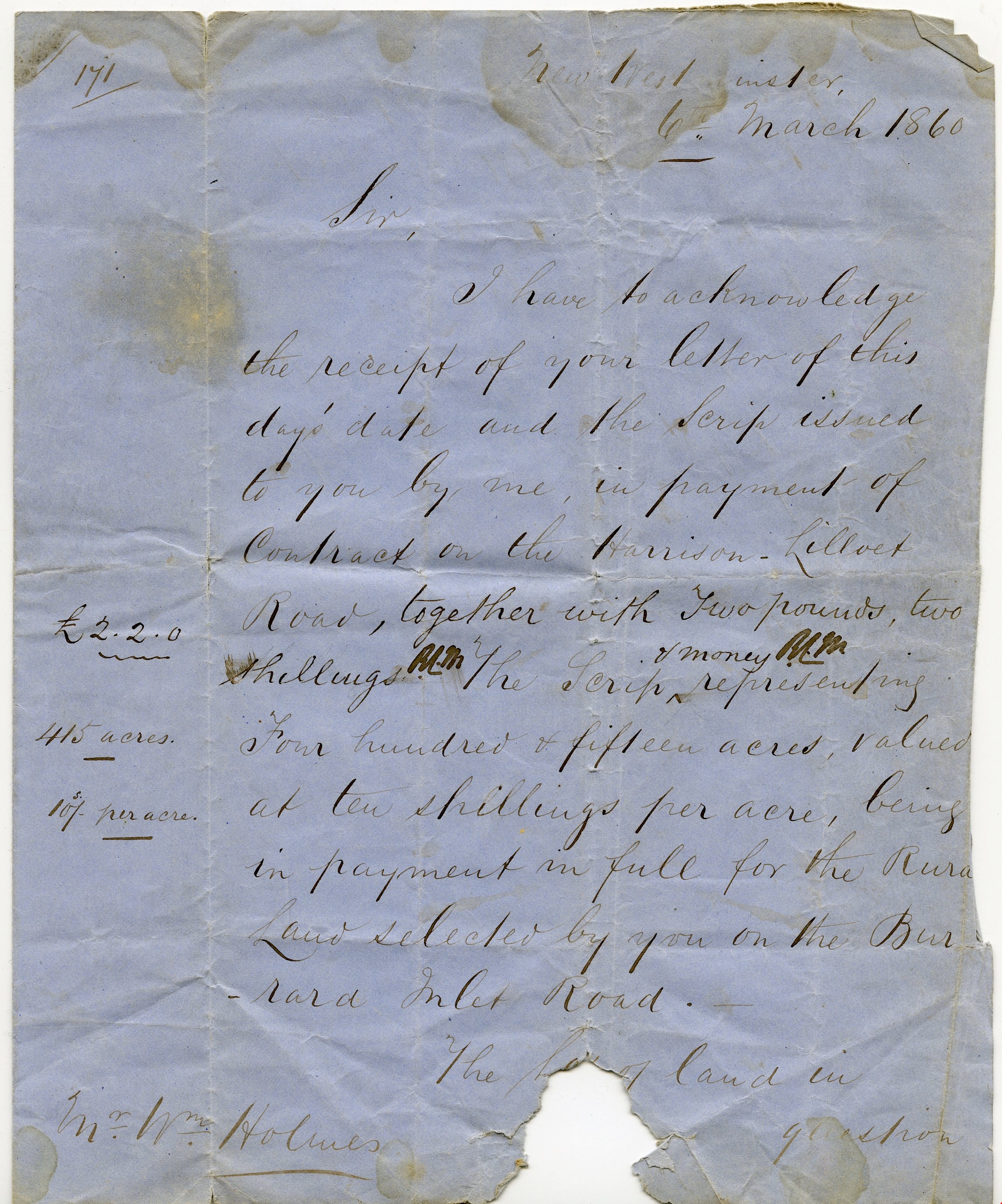
- Item consists of a handwritten letter on blue paper dated "6th March 1860". The letter is addressed to Mr. Wm. Holmes from Colonel Moody regarding payment of a contract on Harrison Lilloet Road and two pounds two shillings scrip payment for land on Burrard Inlet Road..."Lot No. 1, Group 1, Rural La…
- Repository
- Burnaby Village Museum
- Collection/Fonds
- William Holmes fonds
- Description Level
- Item
- Physical Description
- 1 p. textual record ; folded
- Scope and Content
- Item consists of a handwritten letter on blue paper dated "6th March 1860". The letter is addressed to Mr. Wm. Holmes from Colonel Moody regarding payment of a contract on Harrison Lilloet Road and two pounds two shillings scrip payment for land on Burrard Inlet Road..."Lot No. 1, Group 1, Rural Land, New Westminster District..."
- Accession Code
- BV997.50.3
- Access Restriction
- No restrictions
- Reproduction Restriction
- No known restrictions
- Date
- 6 Mar. 1860
- Media Type
- Textual Record
- Scan Resolution
- 300
- Scan Date
- 06-May-2019
- Notes
- Title based on contents of item
Images


Douglas Road
https://search.heritageburnaby.ca/link/landmark714
- Repository
- Burnaby Heritage Planning
- Associated Dates
- 1865
- Heritage Value
- Douglas Road was built between 1862-1865 by the Royal Engineers based in New Westminster. Originally known as the Douglas Street Trail, it took its name from Governor James Douglas. In 1926 a new connection was made to reach Grandview Road in Vancouver at Boundary Road. To distinguish this new highway it was renamed the Grandview Highway and it became commonly known as the combined Grandview-Douglas Highway until 1968 when the Burnaby and New Westminister sections were renamed Canada Way, in recognition of Canada's Centennial in 1967. The old part of Douglas Road north of Sprott Street remained intact.
- Historic Neighbourhood
- Burnaby Lake (Historic Neighbourhood)
- Planning Study Area
- Douglas-Gilpin Area
- Street View URL
- Google Maps Street View
Images

![Gilley Brothers Logging team, [1895]. . thumbnail](/media/hpo/_Data/_Archives_Images/_Unrestricted/371/461-003.jpg?width=280)
Vancouver Road (Kingsway)
https://search.heritageburnaby.ca/link/landmark729
- Repository
- Burnaby Heritage Planning
- Associated Dates
- 1860
- Heritage Value
- The street we know as Kingsway is one of the legacies of the Royal Engineers' military defences for New Westminster. The fear of an American attack prompted the construction of the False Creek trail - later known as Vancouver Road and now Kingsway - in 1860 to connect the capital city to the ice-free salt water harbour at English Bay.
- Historic Neighbourhood
- Central Park (Historic Neighbourhood)
- Edmonds (Historic Neighbourhood)
- Planning Study Area
- Maywood Area
- Marlborough Area
- Windsor Area
- Kingsway-Beresford Area
- Stride Avenue Area
- Edmonds Area
Images
![Gilley Brothers Logging team, [1895]. . thumbnail](/media/hpo/_Data/_Archives_Images/_Unrestricted/371/461-003.jpg)