Narrow Results By
Decade
- 2020s 153
- 2010s 212
- 2000s
- 1990s 654
- 1980s
- 1970s 1013
- 1960s 315
- 1950s 394
- 1940s 583
- 1930s 545
- 1920s 477
- 1910s 477
- 1900s 405
- 1890s 117
- 1880s 26
- 1870s 14
- 1860s
- 1850s 5
- 1840s 3
- 1830s 3
- 1820s 3
- 1810s 3
- 1800s 3
- 1790s 3
- 1780s 3
- 1770s 3
- 1760s 3
- 1750s 3
- 1740s 3
- 1730s 3
- 1720s 3
- 1710s 3
- 1700s 3
- 1690s 3
- 1680s 3
- 1670s 3
- 1660s 3
- 1650s 3
- 1640s 3
- 1630s 3
- 1620s 3
- 1610s 3
- 1600s 3
- 1520s 1
![Staff at Sperling Elementary School, [1980-1981] thumbnail](/media/hpo/_Data/_BVM_Images/2007/2007_0026_0039_001.jpg?width=280)
Staff at Sperling Elementary School
https://search.heritageburnaby.ca/link/museumdescription2858
- Repository
- Burnaby Village Museum
- Date
- [1980-1981]
- Collection/Fonds
- Burnaby Village Museum Photograph collection
- Description Level
- Item
- Scope and Content
- Photograph: Sperling Elementary staff photograph for the 1980 to 1981 school year.
- Repository
- Burnaby Village Museum
- Collection/Fonds
- Burnaby Village Museum Photograph collection
- Description Level
- Item
- Scope and Content
- Photograph: Sperling Elementary staff photograph for the 1980 to 1981 school year.
- Subjects
- Occupations - Teachers
- Accession Code
- BV007.26.39
- Access Restriction
- Restricted access
- Reproduction Restriction
- May be restricted by third party rights
- Date
- [1980-1981]
- Media Type
- Photograph
- Scan Resolution
- 300
- Scan Date
- 29-Nov-2018
- Scale
- 96
Images
![Staff at Sperling Elementary School, [1980-1981] thumbnail](/media/hpo/_Data/_BVM_Images/2007/2007_0026_0039_001.jpg)
![Staff at Sperling Elementary School, [1981-1982] thumbnail](/media/hpo/_Data/_BVM_Images/2007/2007_0026_0040_001.jpg?width=280)
Staff at Sperling Elementary School
https://search.heritageburnaby.ca/link/museumdescription2859
- Repository
- Burnaby Village Museum
- Date
- [1981-1982]
- Collection/Fonds
- Burnaby Village Museum Photograph collection
- Description Level
- Item
- Scope and Content
- Photograph: Sperling Elementary staff photograph for the 1981 to 1982 school year.
- Repository
- Burnaby Village Museum
- Collection/Fonds
- Burnaby Village Museum Photograph collection
- Description Level
- Item
- Scope and Content
- Photograph: Sperling Elementary staff photograph for the 1981 to 1982 school year.
- Subjects
- Occupations - Teachers
- Accession Code
- BV007.26.40
- Access Restriction
- Restricted access
- Reproduction Restriction
- May be restricted by third party rights
- Date
- [1981-1982]
- Media Type
- Photograph
- Scan Resolution
- 300
- Scan Date
- 29-Nov-2018
- Scale
- 96
Images
![Staff at Sperling Elementary School, [1981-1982] thumbnail](/media/hpo/_Data/_BVM_Images/2007/2007_0026_0040_001.jpg)
![Staff at Sperling Elementary School, [1982-1983] thumbnail](/media/hpo/_Data/_BVM_Images/2007/2007_0026_0041_001.jpg?width=280)
Staff at Sperling Elementary School
https://search.heritageburnaby.ca/link/museumdescription2860
- Repository
- Burnaby Village Museum
- Date
- [1982-1983]
- Collection/Fonds
- Burnaby Village Museum Photograph collection
- Description Level
- Item
- Scope and Content
- Photograph: Sperling Elementary staff photograph for the 1982 to 1983 school year. F.H. Allder was principal at this time.
- Repository
- Burnaby Village Museum
- Collection/Fonds
- Burnaby Village Museum Photograph collection
- Description Level
- Item
- Scope and Content
- Photograph: Sperling Elementary staff photograph for the 1982 to 1983 school year. F.H. Allder was principal at this time.
- Subjects
- Occupations - Teachers
- Accession Code
- BV007.26.41
- Access Restriction
- Restricted access
- Reproduction Restriction
- May be restricted by third party rights
- Date
- [1982-1983]
- Media Type
- Photograph
- Scan Resolution
- 300
- Scan Date
- 29-Nov-2018
- Scale
- 96
Images
![Staff at Sperling Elementary School, [1982-1983] thumbnail](/media/hpo/_Data/_BVM_Images/2007/2007_0026_0041_001.jpg)
![Staff at Sperling Elementary School, [1984-1985] thumbnail](/media/hpo/_Data/_BVM_Images/2007/2007_0026_0042_001.jpg?width=280)
Staff at Sperling Elementary School
https://search.heritageburnaby.ca/link/museumdescription2861
- Repository
- Burnaby Village Museum
- Date
- [1984-1985]
- Collection/Fonds
- Burnaby Village Museum Photograph collection
- Description Level
- Item
- Scope and Content
- Photograph: Sperling Elementary staff photograph for the 1984 to 1985 school year.
- Repository
- Burnaby Village Museum
- Collection/Fonds
- Burnaby Village Museum Photograph collection
- Description Level
- Item
- Scope and Content
- Photograph: Sperling Elementary staff photograph for the 1984 to 1985 school year.
- Subjects
- Occupations - Teachers
- Accession Code
- BV007.26.42
- Access Restriction
- Restricted access
- Reproduction Restriction
- May be restricted by third party rights
- Date
- [1984-1985]
- Media Type
- Photograph
- Scan Resolution
- 300
- Scan Date
- 29-Nov-2018
- Scale
- 96
Images
![Staff at Sperling Elementary School, [1984-1985] thumbnail](/media/hpo/_Data/_BVM_Images/2007/2007_0026_0042_001.jpg)
![Survey and Subdivision plans in New Westminster District Group 1 – Burnaby
, [1861]-[1910] thumbnail](/media/hpo/_Data/_BVM_Cartographic_Material/1977/1977_0093_0019a_001.jpg?width=280)
Survey and Subdivision plans in New Westminster District Group 1 – Burnaby
https://search.heritageburnaby.ca/link/museumdescription6988
- Repository
- Burnaby Village Museum
- Date
- [1861]-[1910]
- Collection/Fonds
- Burnaby Village Museum Map collection
- Description Level
- File
- Physical Description
- 14 plans : 3 plans : black ink on paper hand col. + 7 plans : black ink on paper + 4 plans : graphite on paper mounted on 2 sides of cardboard 76 x 102 cm
- Scope and Content
- Item consists of a large board of four New Westminster District Gp 1 - subdivision plans mounted on one side and ten New Westminster District Gp 1 - subdivision plans mounted on the other side. Side A: 1. "Plan /of / Lots 166A, 166 and 167 /, Gr.1, N.W.D. / Showing Misconstructed Roads in Gree…
- Repository
- Burnaby Village Museum
- Collection/Fonds
- Burnaby Village Museum Map collection
- Description Level
- File
- Physical Description
- 14 plans : 3 plans : black ink on paper hand col. + 7 plans : black ink on paper + 4 plans : graphite on paper mounted on 2 sides of cardboard 76 x 102 cm
- Material Details
- Scales [between 1:2376 and 1:7920]
- Index number on edge of board reads: "19"
- Scope and Content
- Item consists of a large board of four New Westminster District Gp 1 - subdivision plans mounted on one side and ten New Westminster District Gp 1 - subdivision plans mounted on the other side. Side A: 1. "Plan /of / Lots 166A, 166 and 167 /, Gr.1, N.W.D. / Showing Misconstructed Roads in Green / 5 chs = 1 in.". (plan is drawn in black ink and hand coloured in red, green and orange ink). A section in the centre of the plan is coloured in red ink and identified as "C.S. Richmond" running from the North Arm of Fraser River to Wiggins Road and divided by "New Wiggins Rd. (as gazetted)" (coloured in orange ink) and two"Constructed Road(s)" (coloured in green ink). Plan is initialed by: "RB" [sic] (in blue pencil crayon) 2. Plan of / Subdivision of / Lot 166 / Group One / New Westminster District / Scale 4 chs = 1 in. / Map No 524". Plan is drawn in graphite and signed by "Surrig [sic] Welhams [sic] / P.L.S." Plan is initialed by: "RB" [sic] (in blue pencil crayon) 3. Plan of "Survey / of Highway / For / Burnaby Council / in / Lots 13 _14 / Group One / Scale 4 chs = 1 in." Signed by "Albert J. Hill, P.L.S." Caribou Street and Caribou Road run through the centre of the plan. Plan is stamped: "Albert J. Hill, Civil Engineer / and / Provincial Land Surveyor, / New Westminster, / B.C.". Plan is initialed by: "RB" [sic] (in blue pencil crayon) 4. A Plan of Lots 166A, 166 and 167, Group One, New Westminster District (drawn in graphite). A section in the centre of the plan is identified as "C.S. Richmond" running from the North Arm of Fraser River and divided by "New Wiggins Rd. (as gazetted)" and two "Constructed Road(s)". Plan is initialed by: "RB" [sic] (in blue pencil crayon) Side B: 1. Small plan drawn in black ink (no title) identifying lots north of the "North Arm" of the Fraser River. Lots identified include: Lot 99, Lot 98, Lot 157, Lot 158, Lot 163, Lot 162, Lot 159, Lot 163, Lot 162, Lot 165, Lot 166A, Lot 155B, Lot 155A and Lot 159. "Scale 40 chains to one inch" . Plan is initialed by: "RB" [sic] (in blue pencil crayon) (Geographic location: Burnaby) 2. Small plan drawn in black ink (no title) identifying lots north of the North Arm of the Fraser River as "Lots 155, 155A, 155B, 155C, 162, 163, 164, 165, 166A and 167". Plan is initialed by: "RB" [sic] (in blue pencil crayon) (Geographic location: Burnaby) 3. Small plan drawn in black ink (no title) which identifies "Lot 151 / Reserve/ for / Race Course"; "Reserve / 64 A / L. 152 G.1"; and other Lots: 32, 33, 34, 35, 36, 38, 39. The plan is signed "Surveyor G.Turn [sic] July / 61 / from Vol 40 R.L. notes [sic]" Plan is stamped: "Albert J. Hill, Civil Engineer / and / Provincial Land Surveyor, / New Westminster, / B.C." Plan is initialed by: "RB" [sic] (in blue pencil crayon) (Geographic location: Burnaby) 4. Small plan drawn in black in with faded red colouring on centre lot identified as "Lot 34" running north from "Vancouver Road" . Plan is stamped: "Albert J. Hill, Civil Engineer / and / Provincial Land Surveyor, / New Westminster, / B.C." Plan is initialed by: "RB" [sic] (in blue pencil crayon) (Geographic location: Burnaby) 5. Plan drawn in graphite and identified as "Lot 98, Gr.1," along with the intials "RB" [sic] (both are handwritten in blue crayon pencil on top of plan) The B.C.E.Railway is identified running through the plan along with Jubilee Road and Royal Oak Road. The plan is signed with the name "Wm. Murray" and the Plan is stamped: "Albert J. Hill, Civil Engineer / and / Provincial Land Surveyor, / New Westminster, / B.C.". (Geographic location: Burnaby) 6. Plan drawn in graphite identified as "Port Lot 13, Gr.1" along with the intials "RB" [sic] (both are handwritten in blue crayon pencil on top of plan) Plan is stamped: "Albert J. Hill, Civil Engineer / and / Provincial Land Surveyor, / New Westminster, / B.C.". (Geographic location: Burnaby) 7.Plan drawn in black ink and identified as "Lot 98 G.1" along with the intials "RB" [sic] (both are handwritten in blue crayon pencil on top of plan). A "Road Reservation" is identified running north between "Electric Tramway" and connecting with "Royal Oak Road". Plan is stamped: "Albert J. Hill, Civil Engineer / and / Provincial Land Surveyor, / New Westminster, / B.C." (Geographic location: Burnaby) 8. Plan drawn in black ink and divided into two sections, the upper plan is identified as "Portion / Lots 100 / area / 101, Gr.1" and the lower plan is identified as "Portion L. 3 G. 1" along with the intials "RB" [sic] (these identifiers are handwritten in blue crayon pencil on top of the plan). Portions of Lot 100 and Lot 101 are each divided into 6 sections and the Portion of Lot 3 plan is divided into 24 sections. The plan includes a note in black ink that reads: " Received from Wm Fromme [sic] / from Wm. Trapp / Nov. 28, 1895 / A. J. T...[sic]". (Geographic location: Burnaby) 9. Plan drawn in black ink (no title) identifying soil, buildings and geographic features in southern Burnaby. The plan is bordered by "New Westminster City" (Tenth Avenue and DL 172) to the south east and DL 173 to the south, DL 158 to the west and the B.C.E. Tramway to the north. Plan includes District Lots: 155A, 158, 159, 171, 160, 53 and 95 and identifies soil, marshland and ravines throughout. Plan identifies the following features: a "Team Road" running through Lots 158 and 159 along with "Fair Orchard Soil / Even Surface Throughout / No Ravines", "Gravel and Shingle" (bottom of Lot 158), "North Arm Road" crossing "Byrne Road" and connecting with "Power House Road" which runs north to connect with "Highland Park Station" and the B.C.E. Tramway, "Power Ho" in the northeast corner of DL 160, a "Brook" connected with a "Deep Ravine" running between DL 53, DL 95 and DL 160 along with "Good Soil" and "Fair Orchard Soil" identified nearby in DL 95. Scale is identified as "10 chs = 1 in." Plan is stamped: "Albert J. Hill, Civil Engineer / and / Provincial Land Surveyor, / New Westminster, / B.C." Plan is initialed by: "RB" [sic] (in blue pencil crayon) (Geographic location: Burnaby) 10. Plan drawn in black ink (no title) with Burnaby Lake and Deer Lake at the centre. The plan is bordered by the following District Lots identified as: 117, 118 and 68 to the west, Lots 80, 79 and 85 to the southwest, Lots 11, 13, and 1 (City of New Westminster) to the south east, the North Road boundary to the east and Lots 8, 56, 57, 59, and 136 to the North. The lower right hand corner of the plan has a small inset which reads: "Burnaby Lake" and "Page 19 R.B. Notes". Plan is initialed by: "RB" [sic] (in blue pencil crayon) (Geographic location: Burnaby)
- Creator
- Hill, Albert James
- Accession Code
- HV977.93.19
- Access Restriction
- No restrictions
- Reproduction Restriction
- No known restrictions
- Date
- [1861]-[1910]
- Media Type
- Cartographic Material
- Scan Resolution
- 300
- Scale
- 72
- Notes
- Title based on contents of file
- Scale is measured in chains. (One chain equals 792 inches)
- The term "Lot" can also refer to a "District Lot”
- Some plans are stamped: "Albert J. Hill, Civil Engineer / and / Provincial Land Surveyor, / New Westminster, / B.C." and intialed: "RB" [sic]
Images
![Survey and Subdivision plans in New Westminster District Group 1 – Burnaby
, [1861]-[1910] thumbnail](/media/hpo/_Data/_BVM_Cartographic_Material/1977/1977_0093_0019a_001.jpg)

![Survey and Subdivision plans in New Westminster District Group 1 – Burnaby, Port Moody, [1862-1908] thumbnail](/media/hpo/_Data/_BVM_Cartographic_Material/1977/1977_0093_0026a_001.jpg?width=280)
Survey and Subdivision plans in New Westminster District Group 1 – Burnaby, Port Moody
https://search.heritageburnaby.ca/link/museumdescription6995
- Repository
- Burnaby Village Museum
- Date
- [1862-1908]
- Collection/Fonds
- Burnaby Village Museum Map collection
- Description Level
- File
- Physical Description
- 9 plans : 6 plans : black ink on paper ; 57 x 36.5 cm or smaller + 1 plan : black ink and grahite on paper ; 46.5 x 49 cm + 1 plan : blueprint on paper ; 15.5 x 19.5 cm + cm + 1 plan : graphite on paper ; 25 x 17 cm ; mounted on both sides of board 76 x 102 cm
- Scope and Content
- Item consists of a large board of four New Westminster District subdivision plans mounted on one side and five New Westminster District subdivision plans mounted on the other side. Side A: 1. "Plan / of Subdivision / of a Portion / of / Lot 87 / Group One / New Westminster District / Scale 4 chs…
- Repository
- Burnaby Village Museum
- Collection/Fonds
- Burnaby Village Museum Map collection
- Description Level
- File
- Physical Description
- 9 plans : 6 plans : black ink on paper ; 57 x 36.5 cm or smaller + 1 plan : black ink and grahite on paper ; 46.5 x 49 cm + 1 plan : blueprint on paper ; 15.5 x 19.5 cm + cm + 1 plan : graphite on paper ; 25 x 17 cm ; mounted on both sides of board 76 x 102 cm
- Material Details
- Scales [between 1:792 and 1:3600]
- Index number on edge of board reads: "26"
- Scope and Content
- Item consists of a large board of four New Westminster District subdivision plans mounted on one side and five New Westminster District subdivision plans mounted on the other side. Side A: 1. "Plan / of Subdivision / of a Portion / of / Lot 87 / Group One / New Westminster District / Scale 4 chs = 1 in". Plan is stamped: "Albert J. Hill, Civil Engineer / and / Provincial Land Surveyor, / New Westminster, / B.C." and intialed by: "RB" [sic] (in blue pencil crayon). Names two of the subdivisons of District Lot 87 are identified as, "L.E. Sprott" and "John Ledger". (Geographic location: Burnaby) 2. "Plan of Subdivision / of / Portions of / Lot 136, 131 and Lots 44 and 78 Gr.1 / New Westminster District / Scale 300 ft = 1 inch". Annotation above title reads: "No. 901 / Deposited in Land Registry Office / New Westminster / Aug. 19th 1905 / Charles S. Keith D. Reg." Annotations and signatures at bottom of plan read: "I, William Nelson Draper, / W.H.R. Collister / Charles E. Perkins / E.B. Morgan / make / Surveys / correct / representation / upon / the / Land Registry Act / (sgd) W.N. Draper, P.L.S.". Plan includes a handwritten title: "Lots 136, 131, 44 & 78" and is initialed: "RB" [sic] (in blue pencil crayon) (Geographic location: Burnaby) 3. "Survey / of / a Portion / of / Lot 95, Gr.1 / Scale 1 ch = 1in." Plan is stamped: "Albert J. Hill, Civil Engineer / and / Provincial Land Surveyor, / New Westminster, / B.C." and is initialed : "RB" [sic] (in blue pencil crayon) (Geographic location: Burnaby) 4. Blueprint plan of "Lot 396. Group One." with Scale : 3 chs = 1 in. A two acre portion of District Lot 396 is filled in with red ink." Plan is signed by "Albert J. Hill / B.C.L.S." (Geographic location: Port Moody) Side B: 1. Plan titled "District Lot 92 / Burnaby / Municipality / for sale by / Mahon / McFarland & / Mahon Ltd. / Vancouver, B.C. / Scale : 4 chains to one inch". District Lot 92 is subdivided into 161 lots and identifies roads: Norwich Road, Pole Line Road, Oakland Road, Stanley Road, Burford Road, Dalhousie Road, Brantford Road, Colborne Road, Roberts Road, Vancouver & Westminster Road, B.C. Electric Railway, Gilley Stn. and Burnaby (Power House). The bottom of the plan reads: "G.S. Dawson, P.LS. Vancouver, B.C." (Geographic location: Burnaby) 2. "Plan / of Subdivision / of a Portion / of / Lot 29 / Group 1 / New Westminster District / Scale 2 chs = 1 in". Plan is stamped: "Albert J. Hill, Civil Engineer / and / Provincial Land Surveyor, / New Westminster, / B.C." and is initialed by: "RB" [sic] (in blue pencil crayon) (Geographic location: Burnaby) 3. Small handrawn plan (no title) identifying "Lot 84 / Hydes, Claim" at the centre surrounded by lots and features identified as: "Lot 85", "Lot 93", "Lot 94", "Lot 32", "Lot 82", "Lot 83", "Lot 79", "swamp" and a "Small Lake" (Burnaby Lake). Identifying marks in the right corner of the plan read: "Page 13 / Surveyed by G. Turner / May 62". Plan also includes surveyor's bearing measurements and trails to "Small Lake" (Burnaby Lake). (Geographic location: Burnaby) 4. Untitled plan showing District Lots west of North Road and north of Burnaby Lake including: Lots 2, 4, 6, 8, 15, 10, 56, 148, 57, 58, 40. and Lots 3, 5, 7 east of North Road (Coquitlam). Lots in Burnaby are identifed for timber including: "Heavily Timbered" (Lot 57), " "Some Fir and Cedar" (Lot 40), "Splendid Fir and Cedar" (Lot 143), "Heavy Fir etc" (Lots 143 and 148), " "Fine Cedar" (Lot 15), "Rough Light Timber" (Lot 56). Other features identified at the lower portion of the plan include "Burnaby Lake" and "Brunette River". (Geographic location: Burnaby) 5. Untitled plan drawn in graphite showing sections of District Lot 85 south of Burnaby Lake and north of Hazsard Road. Plan is signed: "Albert J. Hill / B.C.L.S." and dated "12/26/08". Plan is initialed by: "RB" [sic] (in blue pencil crayon) (Geographic location: Burnaby)
- Publisher
- Mahon, McFarland & Mahon Ltd
- Accession Code
- HV977.93.26
- Access Restriction
- No restrictions
- Reproduction Restriction
- No known restrictions
- Date
- [1862-1908]
- Media Type
- Cartographic Material
- Historic Neighbourhood
- Burnaby Lake (Historic Neighbourhood)
- Burquitlam (Historic Neighbourhood)
- Planning Study Area
- Burnaby Lake Area
- Scan Resolution
- 300
- Scale
- 72
- Notes
- Title based on contents of file
- Scale is measured in chains and feet. (One chain equals 792 inches)
- The term "Lot" can also refer to a "District Lot”
Images
![Survey and Subdivision plans in New Westminster District Group 1 – Burnaby, Port Moody, [1862-1908] thumbnail](/media/hpo/_Data/_BVM_Cartographic_Material/1977/1977_0093_0026a_001.jpg)


![Svend Robinson on the carousel, [between 1989 and 1999] thumbnail](/media/hpo/_Data/_BVM_Images/2015/2015_0041_0100_001.jpg?width=280)
Svend Robinson on the carousel
https://search.heritageburnaby.ca/link/museumdescription9657
- Repository
- Burnaby Village Museum
- Date
- [between 1989 and 1999]
- Collection/Fonds
- Keith Jamieson fonds
- Description Level
- Item
- Physical Description
- 1 photograph : col ; copy print ; 10.5 x 10 cm
- Scope and Content
- Svend Robinson Burnaby MP on the carousel. He is riding a white horse that is holding its head up high and wearing a brown bridle.
- Repository
- Burnaby Village Museum
- Collection/Fonds
- Keith Jamieson fonds
- Description Level
- Item
- Physical Description
- 1 photograph : col ; copy print ; 10.5 x 10 cm
- Material Details
- Printed label in scrapbook beneath photograph read: "SWEND[sic] ROBINSON (M.P.)".
- Scope and Content
- Svend Robinson Burnaby MP on the carousel. He is riding a white horse that is holding its head up high and wearing a brown bridle.
- History
- From Scrapbook vol III The Story in Photographs Continues. In 1989, Ms. Venus Solano and Mr. Doug McCalum and other local people came together to "Save the Carousel" and formed the "Friends of the Vancouver Carousel Society". In May 1989, Burnaby Village Museum agreed to provide a home for the carousel and the "Friends", led by President Don Wrigley, set about raising the $350,000 to purchase the machine. Keith Jamieson, a carousel expert, was brought in to coordinate the rebuilding project. With a lot of hard work, the help of the Government of British Columbia and the support of the Municipality of Burnaby, the carousel was purchased. Funds were also raised to pay for the restoration, and Burnaby agreed to build a new pavilion for it as a Centennial project.
- Other Title Information
- title based on contents of photograph
- Subjects
- Recreational Devices - Carousels
- Names
- Lower Mainland Association of the Friends of the Vancouver Carousel
- Jamieson, Keith
- Jamieson, Pat
- Pacific National Exhibition (PNE)
- C.W. Parker no. 119 Carousel
- Accession Code
- BV015.41.100
- Date
- [between 1989 and 1999]
- Media Type
- Photograph
- Scan Resolution
- 600
- Scan Date
- 17-Sep-18
- Notes
- The photograph was removed from the scrapbook titled, "Parker Carousel Volume III- The Story in Photographs Continues" (BV015.41.3) . The scrapbook is a photograph album providing a detailed account regarding the restoration (before and after) and reassembly of the Parker #119 carousel.
Images
![Svend Robinson on the carousel, [between 1989 and 1999] thumbnail](/media/hpo/_Data/_BVM_Images/2015/2015_0041_0100_001.jpg)
![Switching engines at BC Hydro, Trap Yard, New Westminster, [1985] thumbnail](/media/hpo/_Data/_BVM_Images/2012/2012_0018_0001_001.jpg?width=280)
Switching engines at BC Hydro, Trap Yard, New Westminster
https://search.heritageburnaby.ca/link/museumdescription2878
- Repository
- Burnaby Village Museum
- Date
- [1985]
- Collection/Fonds
- Burnaby Village Museum Photograph collection
- Description Level
- Item
- Physical Description
- 1 photograph : col. ; 20 x 20 cm
- Scope and Content
- Photograph of BC Hydro, Trap Yard, New Westminster. There appears to be six yellow Hydro switching engines on tracks in front of engine maintanence building.
- Repository
- Burnaby Village Museum
- Collection/Fonds
- Burnaby Village Museum Photograph collection
- Description Level
- Item
- Physical Description
- 1 photograph : col. ; 20 x 20 cm
- Scope and Content
- Photograph of BC Hydro, Trap Yard, New Westminster. There appears to be six yellow Hydro switching engines on tracks in front of engine maintanence building.
- Subjects
- Transportation - Locomotives
- Accession Code
- BV012.18.1
- Access Restriction
- No restrictions
- Reproduction Restriction
- No known restrictions
- Date
- [1985]
- Media Type
- Photograph
- Historic Neighbourhood
- Fraser Arm (Historic Neighbourhood)
- Planning Study Area
- Big Bend Area
- Scan Resolution
- 300
- Scan Date
- 13-Mar-2018
- Photographer
- Carson, Dwight W.
- Notes
- Title based on contents of photograph
Images
![Switching engines at BC Hydro, Trap Yard, New Westminster, [1985] thumbnail](/media/hpo/_Data/_BVM_Images/2012/2012_0018_0001_001.jpg)
Thomas "Robert" Love
https://search.heritageburnaby.ca/link/museumdescription9854
- Repository
- Burnaby Village Museum
- Date
- [1988]-1993
- Collection/Fonds
- Burnaby Village Museum fonds
- Description Level
- File
- Physical Description
- 1 cm of textual records
- Scope and Content
- File consists of a copies vital statistical information, notes, and a copy of an "In memoriam" card for Thomas "Robert"Love who died November 23, 1918.
- Repository
- Burnaby Village Museum
- Collection/Fonds
- Burnaby Village Museum fonds
- Series
- Jesse Love farmhouse series
- Subseries
- Love farmhouse research files subseries
- Description Level
- File
- Physical Description
- 1 cm of textual records
- Scope and Content
- File consists of a copies vital statistical information, notes, and a copy of an "In memoriam" card for Thomas "Robert"Love who died November 23, 1918.
- Accession Code
- BV018.41.65
- Access Restriction
- Subject to FIPPA
- Reproduction Restriction
- Reproductions subject to FIPPA
- Date
- [1988]-1993
- Media Type
- Textual Record
- Notes
- Title based on content of file
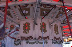
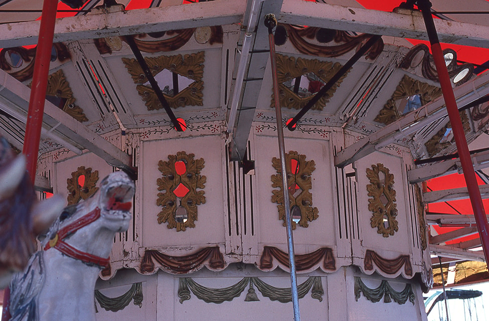
Top level of scenery on the doghouse of the C.W. Parker no. 119 carousel at PNE
https://search.heritageburnaby.ca/link/museumdescription18227
- Repository
- Burnaby Village Museum
- Date
- 1989
- Collection/Fonds
- Burnaby Village Museum fonds
- Description Level
- Item
- Physical Description
- 1 photograph : col. slide ; 35 mm
- Scope and Content
- Photograph of top level of scenery on the doghouse of the C.W. Parker no. 119 carousel while it was in operation inside Playland at the Provincial National Exhibition "PNE".
- Repository
- Burnaby Village Museum
- Collection/Fonds
- Burnaby Village Museum fonds
- Subseries
- Carousel photographs subseries
- Description Level
- Item
- Physical Description
- 1 photograph : col. slide ; 35 mm
- Scope and Content
- Photograph of top level of scenery on the doghouse of the C.W. Parker no. 119 carousel while it was in operation inside Playland at the Provincial National Exhibition "PNE".
- Accession Code
- BV022.2.83
- Access Restriction
- No restrictions
- Reproduction Restriction
- No known restrictions
- Date
- 1989
- Media Type
- Photograph
- Scan Resolution
- 2400
- Scan Date
- 2022-02-09
- Photographer
- Stevens, Colin
- Notes
- Title based on contents of photograph
- Stamp on slide frame reads: "SEPT 25, 1989"
Images
![Trimming a cedar hedge, [2003] thumbnail](/media/hpo/_Data/_Archives_Images/_Unrestricted/535/535-2018.jpg?width=280)
Trimming a cedar hedge
https://search.heritageburnaby.ca/link/archivedescription96337
- Repository
- City of Burnaby Archives
- Date
- [2003]
- Collection/Fonds
- Burnaby NewsLeader photograph collection
- Description Level
- Item
- Physical Description
- 1 photograph (tiff) : col.
- Scope and Content
- Photograph of an arborist in the bucket of a cherry picker, next to a large cedar hedge on Canada Way.
- Repository
- City of Burnaby Archives
- Date
- [2003]
- Collection/Fonds
- Burnaby NewsLeader photograph collection
- Physical Description
- 1 photograph (tiff) : col.
- Description Level
- Item
- Record No.
- 535-2018
- Access Restriction
- No restrictions
- Reproduction Restriction
- No restrictions
- Accession Number
- 2018-12
- Scope and Content
- Photograph of an arborist in the bucket of a cherry picker, next to a large cedar hedge on Canada Way.
- Media Type
- Photograph
- Photographer
- Bartel, Mario
- Notes
- Title based on caption
- Collected by editorial for use in a February 2003 issue of the Burnaby NewsLeader
- Caption from metadata: "A tree trimmer assesses the enormity of the task ahead of him, as he cuts back the huge cedar hedge along Canada Way near the Burnaby Village Museum."
- Geographic Access
- Canada Way
- Historic Neighbourhood
- Burnaby Lake (Historic Neighbourhood)
- Planning Study Area
- Morley-Buckingham Area
Images
![Trimming a cedar hedge, [2003] thumbnail](/media/hpo/_Data/_Archives_Images/_Unrestricted/535/535-2018.jpg)
![Unidentified couple, [186-] thumbnail](/media/hpo/_Data/_BVM_Images/2000/200500590016.jpg?width=280)
Unidentified couple
https://search.heritageburnaby.ca/link/museumdescription1949
- Repository
- Burnaby Village Museum
- Date
- [186-]
- Collection/Fonds
- Burnaby Village Museum Photograph collection
- Description Level
- Item
- Physical Description
- 1 photograph : b&w tintype ; 8 x 6 cm
- Scope and Content
- Photograph of an unidentified couple taken in a photographic studio. The man is standing, wearing a three piece suit (his blazer has been left unbuttoned), with his hat held in his right hand. The woman is seated beside him, in a simple dress with a lace collar.
- Repository
- Burnaby Village Museum
- Collection/Fonds
- Burnaby Village Museum Photograph collection
- Description Level
- Item
- Physical Description
- 1 photograph : b&w tintype ; 8 x 6 cm
- Scope and Content
- Photograph of an unidentified couple taken in a photographic studio. The man is standing, wearing a three piece suit (his blazer has been left unbuttoned), with his hat held in his right hand. The woman is seated beside him, in a simple dress with a lace collar.
- Accession Code
- BV005.59.16
- Access Restriction
- No restrictions
- Reproduction Restriction
- No known restrictions
- Date
- [186-]
- Media Type
- Photograph
- Scan Resolution
- 600
- Scan Date
- 11-Jun-09
- Scale
- 100
- Notes
- Title based on contents of photograph
Images
![Unidentified couple, [186-] thumbnail](/media/hpo/_Data/_BVM_Images/2000/200500590016.jpg)
Valley Bakery staff preparing buns
https://search.heritageburnaby.ca/link/museumdescription5821
- Repository
- Burnaby Village Museum
- Date
- [1980-1989]
- Collection/Fonds
- Burnaby Village Museum Photograph collection
- Description Level
- Item
- Physical Description
- 1 photograph : colour ; copy scan
- Scope and Content
- Photograph of Valley Bakery staff preparing buns. Women identified as Anne McDonald and Doreen (last name unknown).
- Repository
- Burnaby Village Museum
- Collection/Fonds
- Burnaby Village Museum Photograph collection
- Description Level
- Item
- Physical Description
- 1 photograph : colour ; copy scan
- Scope and Content
- Photograph of Valley Bakery staff preparing buns. Women identified as Anne McDonald and Doreen (last name unknown).
- History
- Valley Bakery was started in Burnaby in 1957 by Gerardus "George" Jacobus Kuyer. George started as an apprentice baker in Holland at age 13 and came from the Netherlands to Canada in 1954. He originally opened Valley Bakery at 4059 Hastings Street, near Gilmore Avenue. The bakery later moved to four other premises over the years, before opening at the present location at 4058 East Hastings Street. Valley Bakery brought European baking to the Burnaby area. Son Jack Kuyer bought the bakery from his father in 1979. Jack was an early adopter of using computers to track inventory in the bakery. As a strong community advocate, Jack was one of a few business owners that worked to halt a Department of Highways plan to rid Hastings Street of all street level parking. He was also integral in launching Hats Off Day, a festival designed for local merchants to show their appreciation for their customers. As of 2019, Hats Off Day is Burnaby's largest street festival. In 2015, the Burnaby Board of Trade inducted Valley Bakery into the Burnaby Business Excellence Awards Hall of Fame. The bakery has been in business for over 60 years as of 2019. Anne McDonald was a 21 year employee at Valley Bakery. Born in Scotland, Anne came to Canada as a war bride after serving with the RAF. She died in 1988.
- Other Title Information
- title based on content of photograph
- Names
- Valley Bakery
- Kuyer, Jack
- Accession Code
- BV018.31.6
- Access Restriction
- Restricted access
- Reproduction Restriction
- May be restricted by third party rights
- Date
- [1980-1989]
- Media Type
- Photograph
- Scan Resolution
- 600
- Scan Date
- 27-Sep-2018
- Scale
- 96
![Venus Solano on the carousel, [between 1989 and 1999] thumbnail](/media/hpo/_Data/_BVM_Images/2015/2015_0041_0094_001.jpg?width=280)
Venus Solano on the carousel
https://search.heritageburnaby.ca/link/museumdescription9651
- Repository
- Burnaby Village Museum
- Date
- [between 1989 and 1999]
- Collection/Fonds
- Keith Jamieson fonds
- Description Level
- Item
- Physical Description
- 1 photograph : col. ; copy print ; 12.5 x 10 cm
- Scope and Content
- Venus Solano is on the carousel. She is riding a white horse with a grey mane. Horse has a red bridle. The saddle blanket is blue with three white stars. Breast decoration has flower with four white petals.
- Repository
- Burnaby Village Museum
- Collection/Fonds
- Keith Jamieson fonds
- Description Level
- Item
- Physical Description
- 1 photograph : col. ; copy print ; 12.5 x 10 cm
- Material Details
- Printed label in scrapbook next to photograph read: "VENUS SOLANO".
- Scope and Content
- Venus Solano is on the carousel. She is riding a white horse with a grey mane. Horse has a red bridle. The saddle blanket is blue with three white stars. Breast decoration has flower with four white petals.
- History
- From Scrapbook vol III The Story in Photographs Continues. In 1989, Ms. Venus Solano and Mr. Doug McCalum and other local people came together to "Save the Carousel" and formed the "Friends of the Vancouver Carousel Society". In May 1989, Burnaby Village Museum agreed to provide a home for the carousel and the "Friends", led by President Don Wrigley, set about raising the $350,000 to purchase the machine. Keith Jamieson, a carousel expert, was brought in to coordinate the rebuilding project. With a lot of hard work, the help of the Government of British Columbia and the support of the Municipality of Burnaby, the carousel was purchased. Funds were also raised to pay for the restoration, and Burnaby agreed to build a new pavilion for it as a Centennial project.
- Other Title Information
- title based on contents of photograph
- Subjects
- Recreational Devices - Carousels
- Names
- Lower Mainland Association of the Friends of the Vancouver Carousel
- Jamieson, Keith
- Jamieson, Pat
- Pacific National Exhibition (PNE)
- C.W. Parker no. 119 Carousel
- Accession Code
- BV015.41.94
- Date
- [between 1989 and 1999]
- Media Type
- Photograph
- Scan Resolution
- 600
- Scan Date
- 17-Sep-18
- Notes
- The photograph was removed from the scrapbook titled, "Parker Carousel Volume III- The Story in Photographs Continues" (BV015.41.3) . The scrapbook is a photograph album providing a detailed account regarding the restoration (before and after) and reassembly of the Parker #119 carousel.
Images
![Venus Solano on the carousel, [between 1989 and 1999] thumbnail](/media/hpo/_Data/_BVM_Images/2015/2015_0041_0094_001.jpg)
![The Way it was, [1988] thumbnail](/media/hpo/_Data/_BVM_Textual_Records/2016/2016_0046_0050_002.jpg?width=280)
The Way it was
https://search.heritageburnaby.ca/link/museumdescription4616
- Repository
- Burnaby Village Museum
- Date
- [1988]
- Collection/Fonds
- Waplington family fonds
- Description Level
- Item
- Physical Description
- Textual record : 65 p. + illustrations
- Scope and Content
- Item consists of an unpublished manuscript handwritten and drawn by Frances L. Flemming (nee Waplington), titled "The Way it Was - a very personal account of my childhood 1913-1925" ,"The true and painful history of the Waplington family on which the story of "Lizzie Lau / Wallingford" is based."
- Repository
- Burnaby Village Museum
- Collection/Fonds
- Waplington family fonds
- Description Level
- Item
- Physical Description
- Textual record : 65 p. + illustrations
- Scope and Content
- Item consists of an unpublished manuscript handwritten and drawn by Frances L. Flemming (nee Waplington), titled "The Way it Was - a very personal account of my childhood 1913-1925" ,"The true and painful history of the Waplington family on which the story of "Lizzie Lau / Wallingford" is based."
- Other Title Information
- title continued..."a very personal account of my childhood / 1913-1925"
- Accession Code
- BV016.46.50
- Access Restriction
- Restricted access
- Reproduction Restriction
- Reproductions subject to FIPPA
- Date
- [1988]
- Media Type
- Textual Record
- Related Material
- See also Pioneer Tales pages 337-340
- Notes
- Transcribed title
- An excerpt (pages 52-59) of this manuscript regarding Frances Fleming Waplington's childhood memories of growing up in Burnaby has been made available as a pdf. Contact Burnaby Village Museum to view the Manuscript in it's entirety.
Images
![The Way it was, [1988] thumbnail](/media/hpo/_Data/_BVM_Textual_Records/2016/2016_0046_0050_002.jpg)
Documents
![Wedding at Willingdon United Church, [1982] thumbnail](/media/hpo/_Data/_BVM_Images/2005/2005_0054_0868_005.jpg?width=280)
Wedding at Willingdon United Church
https://search.heritageburnaby.ca/link/museumdescription3871
- Repository
- Burnaby Village Museum
- Date
- [1982]
- Collection/Fonds
- Donald Copan collection
- Description Level
- File
- Physical Description
- 11 photographs : col. negatives ; 40 x 55 mm
- Scope and Content
- Photographs of a wedding ceremony with unidentified individuals at Willingdon Heights United Church on Parker Street in Burnaby.
- Repository
- Burnaby Village Museum
- Collection/Fonds
- Donald Copan collection
- Description Level
- File
- Physical Description
- 11 photographs : col. negatives ; 40 x 55 mm
- Scope and Content
- Photographs of a wedding ceremony with unidentified individuals at Willingdon Heights United Church on Parker Street in Burnaby.
- Subjects
- Ceremonies - Weddings
- Geographic Access
- Parker Street
- Street Address
- 4304 Parker Street
- Accession Code
- BV005.54.868
- Access Restriction
- No restrictions
- Reproduction Restriction
- May be restricted by third party rights
- Date
- [1982]
- Media Type
- Photograph
- Historic Neighbourhood
- Vancouver Heights (Historic Neighbourhood)
- Planning Study Area
- Willingdon Heights Area
- Scan Resolution
- 600
- Scan Date
- August 25, 2020
- Scale
- 100
- Notes
- Title based on content of photographs
- Photograph attached to description: BV005.54.868.5
- Conact Burnaby Village Museum to view other photographs (BV005.54.868.1 to BV005.54.868.11)
Images
![Wedding at Willingdon United Church, [1982] thumbnail](/media/hpo/_Data/_BVM_Images/2005/2005_0054_0868_005.jpg)
William Charles Parker
https://search.heritageburnaby.ca/link/museumdescription9858
- Repository
- Burnaby Village Museum
- Date
- 1988-[1998]
- Collection/Fonds
- Burnaby Village Museum fonds
- Description Level
- File
- Physical Description
- 1 cm of textual records
- Scope and Content
- File consists of copies of an obituary and mass card, biographical notes and a copy of the music for a song titled "the violet" "for Mrs Will Parker / New Westminster / Christmas 1938". William (Bill) Charles Parker is the son of Sarah Parker (nee Love) and William Parker.
- Repository
- Burnaby Village Museum
- Collection/Fonds
- Burnaby Village Museum fonds
- Series
- Jesse Love farmhouse series
- Subseries
- Love farmhouse research files subseries
- Description Level
- File
- Physical Description
- 1 cm of textual records
- Scope and Content
- File consists of copies of an obituary and mass card, biographical notes and a copy of the music for a song titled "the violet" "for Mrs Will Parker / New Westminster / Christmas 1938". William (Bill) Charles Parker is the son of Sarah Parker (nee Love) and William Parker.
- Accession Code
- BV018.41.69
- Access Restriction
- Subject to FIPPA
- Reproduction Restriction
- Reproductions subject to FIPPA
- Date
- 1988-[1998]
- Media Type
- Textual Record
- Notes
- Title based on content of file
William J. Devitt papers
https://search.heritageburnaby.ca/link/archivedescription58429
- Repository
- City of Burnaby Archives
- Date
- 1901-1996 (date of originals)
- Collection/Fonds
- Burnaby Historical Society fonds
- Description Level
- File
- Physical Description
- 1 file of textual records
- Scope and Content
- File consists of photocopied photographs, newspaper articles and correspondence pertaining to William J. "Bill" Devitt, who served as Burnaby Police Chief from 1921 to 1936. These pages were compiled by the Burnaby Village Museum when researching information for the writers of "Follow that Fire."
- Repository
- City of Burnaby Archives
- Date
- 1901-1996 (date of originals)
- Collection/Fonds
- Burnaby Historical Society fonds
- Subseries
- William J. Devitt subseries
- Physical Description
- 1 file of textual records
- Description Level
- File
- Record No.
- MSS082-001
- Accession Number
- BHS1996-17
- Scope and Content
- File consists of photocopied photographs, newspaper articles and correspondence pertaining to William J. "Bill" Devitt, who served as Burnaby Police Chief from 1921 to 1936. These pages were compiled by the Burnaby Village Museum when researching information for the writers of "Follow that Fire."
- Media Type
- Textual Record
- Notes
- Title based on contents of file
Workshop buildings at New Haven
https://search.heritageburnaby.ca/link/museumdescription13535
- Repository
- Burnaby Village Museum
- Date
- Jan. 2001
- Collection/Fonds
- Burnaby Village Museum Photograph collection
- Description Level
- Item
- Physical Description
- 1 photograph : col. ; 5.3 x 10 cm
- Scope and Content
- Photograph of workshop buildings with five bay doors at New Haven Correctional Centre.
- Repository
- Burnaby Village Museum
- Collection/Fonds
- Burnaby Village Museum Photograph collection
- Description Level
- Item
- Physical Description
- 1 photograph : col. ; 5.3 x 10 cm
- Scope and Content
- Photograph of workshop buildings with five bay doors at New Haven Correctional Centre.
- History
- In 1937 New Haven Correctional Centre was established as the British Columbia Training School on the southeast side of Marine Drive in Burnaby (4250 Marine Drive). Sections of Sussex and Patterson Avenues bordered the estate. Originally, the facility housed nineteen inmates with two staff and was one of the first initiatives in Canada to segregate young adult inmates into a separate institution apart from adults. This was part of the Borstal system that started in England whereby young male offenders between the ages of sixteen and twenty one were trained to earn an honest living. Alterations and additions to the estate took place between December 1937 and October 1939 so that more inmates could be accomodated. Five new cottages were built that could hold up to forty people. Except for the plastering and lighting, all work on the new cottages was done by the inmates. On October 29, 1939, the Lieutenant-Governor Eric Hamber formally opened the New Haven Borstal School. World War II interrupted full development of the intstitution and it was closed in 1941 when the inmates were were conscripted into the army. Between 1941 and 1947 the Deaf and Blind Institute were housed at New Haven. In 1947, the New Haven Borstal School returned to the estate. New additions were added to old buildings and new additional buildings were erected on the site over the years including a warden's house on the east grounds and a barn and gymnasium. In the 1970s an equipment shed was added along with another dormitory and a variety of small sheds and storage buildings. The correctional centre officially closed in March 2001.
- Subjects
- Public Services - Correctional
- Geographic Access
- Marine Drive
- Street Address
- 4250 Marine Drive
- Accession Code
- BV020.5.878
- Access Restriction
- No restrictions
- Reproduction Restriction
- No known restrictions
- Date
- Jan. 2001
- Media Type
- Photograph
- Historic Neighbourhood
- Fraser Arm (Historic Neighbourhood)
- Planning Study Area
- Suncrest Area
- Scan Resolution
- 600
- Scan Date
- 25-Aug-2020
- Scale
- 100
- Notes
- Title based on contents of photograph
- Photograph processing stamp on front of photograph reads: "'01_1_13"
- Historical information based on notes from Mary Forsyth's research notes "New Haven" MSS185-018
Images

Transportation and urban development in Vancouver and the Lower Mainland of British Columbia, 1890 - 1915
https://search.heritageburnaby.ca/link/museumlibrary870
- Repository
- Burnaby Village Museum
- Collection
- Reference Collection
- Material Type
- Book
- Call Number
- 388.4 TRA
- Place of Publication
- Burnaby
- Publisher
- Burnaby Village Museum
- Publication Date
- 1986
- Physical Description
- 24 p. : ill. ; 28 cm.
- Library Subject (LOC)
- Electric railroads
- Local transit
- Street-railroads
- Transportation
- Geographic Access
- Vancouver
- Notes
- Spiral bound, master copy.
- Includes 1 copy of distributed version (smaller booklet with clearer photographs)
- Includes bibliographical references