
Bell's Drygoods Store
https://search.heritageburnaby.ca/link/landmark537
- Repository
- Burnaby Heritage Planning
- Description
- Bell’s Drygoods Store is a typical commercial false front, single storey, wood-frame building that has been relocated to the Burnaby Village Museum.
- Associated Dates
- 1922
- Formal Recognition
- Heritage Designation, Community Heritage Register
- Other Names
- Whitechurch Hardware Store
- Repository
- Burnaby Heritage Planning
- Other Names
- Whitechurch Hardware Store
- Geographic Access
- Deer Lake Avenue
- Associated Dates
- 1922
- Formal Recognition
- Heritage Designation, Community Heritage Register
- Enactment Type
- Bylaw No. 9807
- Enactment Date
- 23/11/1992
- Description
- Bell’s Drygoods Store is a typical commercial false front, single storey, wood-frame building that has been relocated to the Burnaby Village Museum.
- Heritage Value
- The value of the Bell’s Drygoods Store lies in its significance as one of the last remaining intact false front retail structures of its time to survive in Burnaby. Additionally, it remains as one of East Burnaby’s few surviving early commercial buildings and is representative of other typical commercial structures of the period. Originally located on Sixth Street in East Burnaby, in a small commercial district that served residents located along the streetcar line between New Westminster and Edmonds, its proximity to the streetcar served to draw customers into the store. This store also served as the location of the East Burnaby Post Office, one of a number of local post offices located throughout the municipality during the early twentieth century. Clifford Tuckey constructed the building in 1922, with a small lean-to structure on the back housing a kitchen and bedroom. The store was sold soon afterwards to William and Flora Bell, who then lived and worked here for a number of years. It represents a traditional relationship of the owner’s home to the store during this period, indicating the modest means of the owners and their commitment to running the business. The building was later sold to Maurice and Mildred Whitechurch, who ran it for many years as a hardware store. In 1974, the structure was relocated to its present site at the Museum. The heritage value for this structure also lies in its interpretive value within the Burnaby Village Museum. The site is an important cultural feature for the interpretation of Burnaby’s heritage to the public. Between 1993 and 1996 the building was restored to its 1925 appearance.
- Defining Elements
- The character defining features of Bell’s Drygoods Store include its: - rectangular form and simple massing - commercial false front parapet - front gable roof with cedar shingle cladding - horizontal lapped wooden siding - recessed main central entrance flanked by large storefront display windows - V-joint tongue-and-groove wood interior paneling - interior separation between commercial and residential space
- Locality
- Deer Lake Park
- Historic Neighbourhood
- Burnaby Lake (Historic Neighbourhood)
- Planning Study Area
- Morley-Buckingham Area
- Organization
- Burnaby Village Museum
- Function
- Primary Current--Museum
- Primary Historic--Shop
- Community
- Burnaby
- Cadastral Identifier
- P.I.D. No. 011-030-356 Legal Description: Parcel 1, District Lot 79 and District Lot 85, Group 1, New Westminster District, Reference Plan 77594
- Boundaries
- Burnaby Village Museum is comprised of a single municipally-owned property located at 6501 Deer Lake Avenue, Burnaby.
- Area
- 38,488.63
- Contributing Resource
- Building
- Landscape Feature
- Structure
- Ownership
- Public (local)
- Documentation
- Heritage Site Files: PC77000 20. City of Burnaby Planning and Building Department, 4949 Canada Way, Burnaby, B.C., V5G 1M2
- Street Address
- 6501 Deer Lake Avenue
Images


East Burnaby Neighbourhood
https://search.heritageburnaby.ca/link/landmark712
- Repository
- Burnaby Heritage Planning
- Associated Dates
- 1925-1954
- Heritage Value
- After a lull in construction during the World War I period, East Burnaby Neighbourhood's growth resumed during the 1920s when many homes and businesses were constructed. The post-World War Two period also saw rapid construction and the creation of new housing developments in response to a population boom. The neighbourhood remained a primarily single-family residential area.
- Historic Neighbourhood
- Edmonds (Historic Neighbourhood)
- Planning Study Area
- Stride Avenue Area
Images


E.W. Bateman House 'Elworth'
https://search.heritageburnaby.ca/link/landmark538
- Repository
- Burnaby Heritage Planning
- Description
- The E.W. Bateman House is a one-and-one-half storey wood-frame residence set within in a garden landscape. The house and its adjacent garage are the only historic buildings standing on their original site within the Burnaby Village Museum property.
- Associated Dates
- 1922
- Formal Recognition
- Heritage Designation, Community Heritage Register
- Other Names
- Edwin & Mary Bateman Residence
- Street View URL
- Google Maps Street View
- Repository
- Burnaby Heritage Planning
- Other Names
- Edwin & Mary Bateman Residence
- Geographic Access
- Deer Lake Avenue
- Associated Dates
- 1922
- Formal Recognition
- Heritage Designation, Community Heritage Register
- Enactment Type
- Bylaw No. 9807
- Enactment Date
- 23/11/1992
- Description
- The E.W. Bateman House is a one-and-one-half storey wood-frame residence set within in a garden landscape. The house and its adjacent garage are the only historic buildings standing on their original site within the Burnaby Village Museum property.
- Heritage Value
- The E.W. Bateman House was constructed in the Deer Lake Crescent subdivision, that was originally promoted in 1911 as an upper class suburban neighbourhood. It represents one of the first residential developments in the City of Burnaby that required buildings to be of a specific value, thus demonstrating the desire for exclusivity among the successful businessmen who chose to settle in the area. The house and grounds illustrate the reduced scale of upper-class residential construction at a time of modest returning prosperity that followed the end of the First World War, and the social, cultural, lifestyle and leisure sensibilities of the owners in the Deer Lake Crescent subdivision: such values as social aspiration, racial exclusivity, demonstration of architectural taste, and importance of a landscaped garden. The heritage value of the E.W. Bateman House is its comprehensive representation of an upper middle-class suburban residence of the early 1920s. It was built for retired CPR executive Edwin Wettenhall Bateman (1859-1957) and his wife, Mary (Dale) Bateman (1865-1935), by contractor William Dodson in 1922. The Bateman House was designed by English-born and trained architect Enoch Evans (1862-1939) of E. Evans and Son, and is an important surviving residential design by Evans, and a typical example of the eclectic Period Revival influences that were common to domestic architecture in the post-First World War era. The symmetry of the imposing front verandah, supported by exaggerated Ionic columns, gives the relatively-modest house an image of grandeur and formality. Named after Edwin Bateman’s birthplace in Cheshire, England, ‘Elworth’ also symbolizes allegiance to England and the patriotic tenor of the time. The heritage value for this house also lies in its interpretive value within the Burnaby Village Museum. The site is an important cultural feature for the interpretation of Burnaby’s heritage to the public. The E.W. Bateman House was purchased by Burnaby in 1970 and became the focal point for the development of the Museum. Both the interior and exterior of the house have been restored and interpreted to the date of original construction, including recreated room interiors and period furnishings.
- Defining Elements
- The elements that define the heritage character of the E.W. Bateman House include its: - rectangular form and massing with central entry on long side - side gable roof with front shed dormer with cedar shingle cladding - symmetry of front facade - full open front verandah inset under the roofline, supported with Ionic columns - cedar shingle siding - multi-paned double-hung wooden-sash windows, mixture of 6-over-1 and 8-over-1 - symmetrical disposition of fenestration, with double-assembly units on the ground floor - exterior shutters - two flanking brick chimneys on the side elevations - interior room layouts and original interior features such as quality millwork and original hardware - original garage at the rear of the house
- Locality
- Deer Lake Park
- Historic Neighbourhood
- Burnaby Lake (Historic Neighbourhood)
- Planning Study Area
- Morley-Buckingham Area
- Organization
- Burnaby Village Museum
- Architect
- Enoch Evans
- E. Evans and Son
- Builder
- William Dodson
- Function
- Primary Current--Museum
- Primary Historic--Single Dwelling
- Community
- Burnaby
- Cadastral Identifier
- P.I.D. No. 011-030-356 Legal Description: Parcel 1, District Lot 79 and District Lot 85, Group 1, New Westminster District, Reference Plan 77594
- Boundaries
- Burnaby Village Museum is comprised of a single municipally-owned property located at 6501 Deer Lake Avenue, Burnaby.
- Area
- 38,488.63
- Contributing Resource
- Building
- Landscape Feature
- Structure
- Ownership
- Public (local)
- Documentation
- Heritage Site Files: PC77000 20. City of Burnaby Planning and Building Department, 4949 Canada Way, Burnaby, B.C., V5G 1M2
- Subjects
- Buildings - Residential
- Buildings - Residential - Houses
- Buildings - Heritage
- Buildings - Civic - Museums
- Street Address
- 6501 Deer Lake Avenue
- Street View URL
- Google Maps Street View
Images


George S. & Jessie Haddon House
https://search.heritageburnaby.ca/link/landmark508
- Repository
- Burnaby Heritage Planning
- Description
- The George and Jessie Haddon House is a symmetrical two-storey Dutch Colonial-style house with a side-gambrel roof and shed dormers. It is situated in the Burnaby Lake neighborhood in East Burnaby.
- Associated Dates
- 1922
- Formal Recognition
- Heritage Designation, Community Heritage Register
- Street View URL
- Google Maps Street View
- Repository
- Burnaby Heritage Planning
- Geographic Access
- Buckingham Avenue
- Associated Dates
- 1922
- Formal Recognition
- Heritage Designation, Community Heritage Register
- Enactment Type
- Bylaw No. 12064
- Enactment Date
- 19/06/2006
- Description
- The George and Jessie Haddon House is a symmetrical two-storey Dutch Colonial-style house with a side-gambrel roof and shed dormers. It is situated in the Burnaby Lake neighborhood in East Burnaby.
- Heritage Value
- Built in 1923, the George and Jessie Haddon House is a significant example of the romantic period revival styles that were popular during the period between the two World Wars. These traditionally styled homes reflected ongoing pride in past traditions but also recognized the modern ideals of economy and good design. At the time, houses displayed traditional and readily-identifiable historical styles as a hallmark of good taste. The use of the various Colonial Revival styles had gained new popularity during the 1920s, and this design could have originated in a residential pattern book, which were in wide circulation and used to expedite residential projects. This house displays the typical features of the Dutch Colonial style, imported from the eastern United States and relatively rare on the West Coast. The house originally featured an unusual porte-cochere with tapered supports, that indicated the growing importance of automobiles at the time. The house was built for George Samuel Haddon (1886-1971) and his wife Jessie (née Reade) Haddon, whom he married in 1915. George Haddon, who was born in British Columbia, was a prominent Vancouver figure and served as Secretary of the Vancouver General Hospital. Following Jessie's death, George Haddon was remarried to Alice Margaret Currie (1890-1951). The George and Jessie Haddon House is further valued for its connection with the continued development of the Burnaby Lake neighbourhood in the 1920s. The area was highly desirable to wealthy Vancouver and New Westminster residents because of its scenery, and easy access was provided by the British Columbia Electric Railway 'Burnaby Lake' interurban line, which opened in June 1911. The Haddon House illustrates the evolving nature of regional transportation and the growing communities made possible by increasing options for transportation. The house originally stood on a larger lot, and was relocated in 2006 to allow for subdivision and legal protection. The current owners restored the porte-cochere in 2014.
- Defining Elements
- Key elements that define the heritage character of the George and Jessie Haddon House include its: - location within the Burnaby Lake neighbourhood - residential form, scale and massing as expressed by its two-storey height and gambrel roof with shed dormers - rough-cast stucco cladding - Colonial Revival details such as the symmetrical façade and massing, and side-gambrel roof with shed dormers - additional exterior features such as an interior chimney, exposed purlins and window boxes supported on large projecting brackets - wooden front door with glazed insets - interior features including original staircase, and wooden door and window trim
- Historic Neighbourhood
- Burnaby Lake (Historic Neighbourhood)
- Planning Study Area
- Morley-Buckingham Area
- Builder
- William Dodson
- Function
- Primary Historic--Single Dwelling
- Cadastral Identifier
- P.I.D.026-745-127
- Boundaries
- The George and Jessie Haddon House is comprised of a single residential lot located at 5558 Buckingham Avenue, Burnaby.
- Area
- 1080
- Contributing Resource
- Building
- Ownership
- Private
- Documentation
- City of Burnaby Planning and Building Department, Heritage Site Files
- Street Address
- 5558 Buckingham Avenue
- Street View URL
- Google Maps Street View
Images


Rev. James Black Residence
https://search.heritageburnaby.ca/link/landmark632
- Repository
- Burnaby Heritage Planning
- Description
- Residential building.
- Associated Dates
- 1925
- Street View URL
- Google Maps Street View
- Repository
- Burnaby Heritage Planning
- Geographic Access
- Sussex Avenue
- Associated Dates
- 1925
- Description
- Residential building.
- Heritage Value
- This home was built as a retirement home for Baptist Missionary Reverend James Black and his family in 1925; the Black family resided in the home until the early 1970s. The Black Residence is a good example of the Period Revival movement that occurred between the two World Wars. At the time, it was considered good taste for a house to have an identifiable historical style. The Black Residence was likely designed by a local architect or built by a contractor using a pattern book plan, and the British Arts and Crafts influence was typical of many middle class homes of the period built in Burnaby. The house was originally located facing Sardis Street with a beautiful garden landscape that was lost when the house was relocated in 2005.
- Locality
- Central Park
- Historic Neighbourhood
- Central Park (Historic Neighbourhood)
- Planning Study Area
- Marlborough Area
- Area
- 639.00
- Contributing Resource
- Building
- Ownership
- Private
- Street Address
- 5688 Sussex Avenue
- Street View URL
- Google Maps Street View
Images


Alta Vista Neighbourhood
https://search.heritageburnaby.ca/link/landmark707
- Repository
- Burnaby Heritage Planning
- Associated Dates
- 1925-1954
- Heritage Value
- As with many areas of Burnaby during this period, the years after World War Two marked a rapid growth in residential development in the Alta-Vista Neighbourhood. Subdivisions like Sussex and Suncrest were built and new schools and amenities were constructed to meet the demands of increased population.
- Historic Neighbourhood
- Alta Vista (Historic Neighbourhood)
- Planning Study Area
- Sussex-Nelson Area
Images


Alta Vista Neighbourhood
https://search.heritageburnaby.ca/link/landmark766
- Repository
- Burnaby Heritage Planning
- Associated Dates
- 1905-1924
- Heritage Value
- Alta Vista, named for its high views of the Fraser Valley, rapidly grew during the period 1910-1912, seeing its settlement jump from about a dozen buildings in 1910 to about four hundred by the end of 1912. Home-seekers were attracted to its location just a short walk from the B.C.E.R. line at Royal Oak and Highland Park and easily accessible to both New Westminster and Vancouver.
- Historic Neighbourhood
- Alta Vista (Historic Neighbourhood)
- Planning Study Area
- Sussex-Nelson Area
Images


Buena Vista Neighbourhood
https://search.heritageburnaby.ca/link/landmark759
- Repository
- Burnaby Heritage Planning
- Associated Dates
- 1905-1924
- Heritage Value
- The Buena Vista neighbourhood (so named for its wonderful views) grew out of its proximity to Edmonds and New Westminster and was developed in the period 1911-1912. By the 1950s, the area had been further subdivided and in 1986, Burnaby Municipal Council adopted the Cariboo Hills Development Plan for the neighbourhood to maintain its character as a residential area of the city.
- Historic Neighbourhood
- East Burnaby (Historic Neighbourhood)
- Planning Study Area
- Cariboo-Armstrong Area
Images


Burquitlam Neighbourhood
https://search.heritageburnaby.ca/link/landmark703
- Repository
- Burnaby Heritage Planning
- Associated Dates
- 1925-1954
- Heritage Value
- By the 1950s, the Burquitlam Neighbourhood was becoming a residential and commercial centre for the northeast section of Burnaby. The Sullivan Heights area was developed as a single-family residential area with the Lyndhurst School opening in 1954. The completion of the Lougheed Highway in 1953 encouraged more commercial and retail development and fostered the growth of the neighbourhood throughout this period.
- Historic Neighbourhood
- Burquitlam (Historic Neighbourhood)
- Planning Study Area
- Lyndhurst Area
Images


Central Park Neighbourhood
https://search.heritageburnaby.ca/link/landmark688
- Repository
- Burnaby Heritage Planning
- Associated Dates
- 1925-1954
- Heritage Value
- Although still largely a rural area during the 1920s, subdivisions began appearing in the Central Park neighbourhood at this time. Development was slowed by the Great Depression of the 1930s but the influx of commercial buildings and new housing initiatives in the post-war boom led to a period of rapid growth especially in the Garden Village subdivision which was undertaken in 1953 with the plan to build 500 modern homes in the 140-acre site. Despite the closure of the interurban line in 1953, the neighbourhood remained an active commercial and residential centre.
- Historic Neighbourhood
- Central Park (Historic Neighbourhood)
- Planning Study Area
- Maywood Area
Images


Edmonds Neighbourhood
https://search.heritageburnaby.ca/link/landmark704
- Repository
- Burnaby Heritage Planning
- Associated Dates
- 1925-1954
- Heritage Value
- The historic growth of Edmonds as a neighbourhood was based on its strategic location on the early interurban line between Vancouver and New Westminster. Even by 1980 when a survey of the residential neighbourhoods was conducted, a full 25% of homes in the area predated 1930. The 1950s was a period of strong housing development, with both single-family and multi-family units being constructed. Although Burnaby's City Hall was moved from Kingsway and Edmonds in the early 1950s, Edmonds remained an important centre in the community.
- Historic Neighbourhood
- Edmonds (Historic Neighbourhood)
- Planning Study Area
- Stride Avenue Area
Images


Floden House
https://search.heritageburnaby.ca/link/landmark524
- Repository
- Burnaby Heritage Planning
- Description
- The Floden House is a gambrel roofed, one and one-half storey plus basement wood-frame Dutch Colonial Revival residence, located at the head of the T-intersection of Fourth Street and Edmonds Street in a residential area of East Burnaby.
- Associated Dates
- 1929
- Formal Recognition
- Heritage Designation, Community Heritage Register
- Other Names
- Eric B. & Carrie Floden House
- Street View URL
- Google Maps Street View
- Repository
- Burnaby Heritage Planning
- Other Names
- Eric B. & Carrie Floden House
- Geographic Access
- 4th Street
- Associated Dates
- 1929
- Formal Recognition
- Heritage Designation, Community Heritage Register
- Enactment Type
- Bylaw No. 11358
- Enactment Date
- 27/05/2002
- Description
- The Floden House is a gambrel roofed, one and one-half storey plus basement wood-frame Dutch Colonial Revival residence, located at the head of the T-intersection of Fourth Street and Edmonds Street in a residential area of East Burnaby.
- Heritage Value
- Built in 1929 for Swedish emigrant Eric Birger Floden (1896-1971) and his Norwegian wife, Carrie (1899-1943), the Floden House is a valued representation of local middle-class housing from the 1920s, at a time of increasing prosperity just prior to the onset of the Great Depression. Eric Birger Floden was the head sawyer at Shook Mills in New Westminster, and his family occupied the house until 1964. Additionally, the Floden House is significant as an example of a residential pattern book design from the 1920s. With a reviving economy after the First World War, pattern books were widely used to expedite residential design and construction. It was built by Floden's brother in-law, Nels Olund, a talented contractor of the Fraser Valley who was experienced in building gambrel roof barns. The Floden House is also valued as an example of the Dutch Colonial Revival style, and is typical of period revival houses built in the 1920s that reflected the modern ideals of economy and good design as well as an ongoing pride in past traditions. It was presumed at the time that a well-built house would display a traditional and readily-identifiable style as a hallmark of good taste. The use of the various Colonial Revival styles had gained new popularity during the late 1920s at the time of the American Sesquicentennial. A local landmark, the house originally stood at 7997 18th Avenue and was moved two blocks to its current location by the City of Burnaby when it purchased and rehabilitated the house to save it from demolition, indicating the City's commitment to heritage conservation.
- Defining Elements
- Key elements that define the heritage character of the Floden House include its: - residential form, scale and massing as expressed by its one and one-half storey plus basement height, rectangular plan and distinctive roof form - Dutch Colonial Revival style details such as its side gambrel roof, front and rear shed dormers, attic fanlights, decorative shutters and regular fenestration - roof configuration, with overhanging eaves on the front facade with returns on the side facades, and clipped eaves on the side facades - asymmetrical front entry with small entry porch with lattice surrounds - front projecting bay window - wide lapped horizontal cedar siding - irregular fenestration, with original double-hung 6-over-1 wooden-sash windows - secondary side entry with balcony over - internal red brick chimney with concrete chimney caps
- Historic Neighbourhood
- East Burnaby (Historic Neighbourhood)
- Planning Study Area
- Edmonds Area
- Builder
- Nels Olund
- Function
- Primary Historic--Single Dwelling
- Primary Current--Single Dwelling
- Community
- Burnaby
- Cadastral Identifier
- 009-931-490
- Boundaries
- The Floden House is comprised of a single residential lot located at 7244 Fourth Street, Burnaby.
- Area
- 804.13
- Contributing Resource
- Building
- Ownership
- Private
- Street Address
- 7244 4th Street
- Street View URL
- Google Maps Street View
Images


John & Jessie MacLean Residence
https://search.heritageburnaby.ca/link/landmark608
- Repository
- Burnaby Heritage Planning
- Description
- Residential building.
- Associated Dates
- c.1926
- Street View URL
- Google Maps Street View
- Repository
- Burnaby Heritage Planning
- Geographic Access
- Pandora Street
- Associated Dates
- c.1926
- Description
- Residential building.
- Heritage Value
- This cottage illustrates the traditionalism of the interwar years, when domestic ideals were expressed through modest homes displaying period revival influences. Reflecting the influence of the British Arts and Crafts movement, it features a symmetrical plan, a side jerkin-headed roof, a gabled front dormer and twin-coursed shingle siding, and retains its original wooden-sash windows with unusual multi-paned upper sash. It was built for John R. and Jessie MacLean. The house was recently restored by the owners.
- Locality
- Vancouver Heights
- Historic Neighbourhood
- Vancouver Heights (Historic Neighbourhood)
- Planning Study Area
- Burnaby Heights Area
- Area
- 566.71
- Contributing Resource
- Building
- Ownership
- Private
- Street Address
- 3827 Pandora Street
- Street View URL
- Google Maps Street View
Images


Lozells Neighbourhood
https://search.heritageburnaby.ca/link/landmark701
- Repository
- Burnaby Heritage Planning
- Associated Dates
- 1925-1954
- Heritage Value
- Like a lot of residential neighbourhoods in Burnaby during the post-War boom, the Lozells area during the 1925-1954 period was one of new construction and subdivisions. Although more homes were being built, the neighbourhood still retained a somewhat rural characteristic well into the 1950s.
- Historic Neighbourhood
- Lozells (Historic Neighbourhood)
- Planning Study Area
- Government Road Area
Images


Vancouver Heights Neighbourhood
https://search.heritageburnaby.ca/link/landmark666
- Repository
- Burnaby Heritage Planning
- Associated Dates
- 1925-1954
- Heritage Value
- Vancouver Heights remained an important residential and commercial centre in Burnaby throughout the 1925-1954 period. The area had its own Board of Trade and the North Burnaby Library was created to serve the residents. In 1949, the Hastings streetcars stopped running, but the area retained its reputation as one of the best shopping districts in the city.
- Historic Neighbourhood
- Vancouver Heights (Historic Neighbourhood)
- Planning Study Area
- Burnaby Heights Area
Images

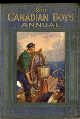
The Canadian boy's annual : 1920
https://search.heritageburnaby.ca/link/museumlibrary3611
- Repository
- Burnaby Village Museum
- Author
- Johnston, Harry H.
- Publication Date
- 1920
- Call Number
- 810.8 CAN
- Repository
- Burnaby Village Museum
- Collection
- Special Collection
- Material Type
- Book
- Accession Code
- BV998.18.1
- Call Number
- 810.8 CAN
- Author
- Johnston, Harry H.
- Place of Publication
- London
- Toronto
- Publisher
- Cassell
- Publication Date
- 1920
- Physical Description
- vii, 232 p., [4] leaves of plates : ill (some col.) ; 24 cm.
- Inscription
- Front endpaper: "Leonard G. Hornett Port Alberni" [written in black ink] "Christmas 1919-1920" [written in pencil underneath "Port Alberni"] "275" [written in pencil]
- Library Subject (LOC)
- Children's literature
- Children's stories
- Short stories
- Gift books
- Periodicals
- Object History
- Purchased by Colin Stevens from the seller.
- Notes
- "Containing stories and articles by Sir Harry H. Johnston, G.G.M.G., Frank H. Shaw, D.H. Parry, Richard Kearton, T.C. Bridges, Captain Gilson, S. Walkey, R.S. Warren Bell, Eric Wook, Percy F. Westerman, H. Mortimer Batten, Captain Oswald Dallas, and many others" -- t.p.
- "With a large number of Illustrations in Colour and Black-and-White" -- t.p.
Images


Popular radio : volume i, number 4
https://search.heritageburnaby.ca/link/museumlibrary5696
- Repository
- Burnaby Village Museum
- Collection
- Special Collection
- Material Type
- Textual Record
- Accession Code
- BV999.32.12
- Call Number
- 621.3 POP
- Contributor
- Banning, Kendall, 1879-1944
- Place of Publication
- New York
- Publisher
- Popular Radio, Inc.
- Publication Date
- August 1922
- Series
- Popular radio, v. 1, no. 4
- Physical Description
- 1 v. (multiple pagings) : ill. : 26 cm.
- Library Subject (LOC)
- Radio
- Periodicals
- Notes
- edited by Kendall Banning
Images


Inkwells to Internet: A History of Burnaby Schools
https://search.heritageburnaby.ca/link/museumlibrary7551
- Repository
- Burnaby Village Museum
- Collection
- Reference Collection
- Digital Reference Collection
- Material Type
- Book
- ISBN
- 978-0-9781979-2-6
- Call Number
- 371 CAR
- Place of Publication
- Burnaby
- Publisher
- City of Burnaby
- Publication Date
- 2020
- Physical Description
- vii, 35 p. : ill. ; 29 cm.
- Library Subject (LOC)
- Burnaby (B.C.)--History
- Schools--British Columbia--Burnaby
- Subjects
- Education
- Notes
- "Includes index"
- A history of the Burnaby school district and individual school buildings in Burnaby, BC, between 1893 and 2013.
- The “First Nations cemetery” described on page 109 in Mary Johnson’s recollections was originally written as “Indian” and may refer to the Khalsa Diwan Society’s Sikh cremations at the Vancouver Cemetery.
Images

Digital Books

Chinese Canadian history in Burnaby resource guide
https://search.heritageburnaby.ca/link/museumlibrary7608
- Repository
- Burnaby Village Museum
- Collection
- Digital Reference Collection
- Material Type
- Digital Resource
- Accession Code
- BV022.8.1
- Call Number
- 971.1 CHI
- Contributor
- City of Burnaby
- Place of Publication
- Burnaby, BC
- Publisher
- City of Burnaby
- Publication Date
- [2022]
- Physical Description
- 36 p. ; ill. (some col.), maps, ports
- Library Subject (LOC)
- Burnaby (B.C.)--History
- Burnaby (B.C.)--Social Life and Customs
- Chinese Canadians--British Columbia--Burnaby--History
- Chinese--British Columbia--History
- Pharmacy--Canada
- Pharmacy--United States
- Pharmaceutical museums
- Directories
- Object History
- Chinese Canadians have contributed to Burnaby’s growth for over a century. The long and intertwining histories between Chinese Canadians, Indigenous people and other communities have shaped the founding of Burnaby and British Columbia. This resource guide was created because their life experiences and important contributions to Burnaby’s development are not widely known.
Images

Digital Books

Eating your way through Burnaby: A look at Chinese Canadian history through food
https://search.heritageburnaby.ca/link/museumdescription14762
- Repository
- Burnaby Village Museum
- Date
- 27 Oct. 2020
- Collection/Fonds
- Burnaby Village Museum fonds
- Description Level
- Item
- Physical Description
- 1 video recording (mp4) (61 min., 56 sec.) : digital, col., sd., stereo ; 29 fps
- Scope and Content
- Item consists of a video recording of a live Zoom webinar hosted by Kate Petrusa, Burnaby Village Museum assistant curator. The webinar is titled "Eating your way through Burnaby: A look at Chinese Canadian history through food" and is presented by Denise Fong, Planning Assistant for the City of Bu…
- Repository
- Burnaby Village Museum
- Collection/Fonds
- Burnaby Village Museum fonds
- Description Level
- Item
- Physical Description
- 1 video recording (mp4) (61 min., 56 sec.) : digital, col., sd., stereo ; 29 fps
- Material Details
- Presenter: Denise Fong
- Host: Kate Petrusa
- Date of Presentation: October 27 7:00 pm - 8:00 pm
- Total Number of tracks: 1
- Total Length of all tracks:61 min., 56 sec.
- Recording Device: Zoom video communication platform
- Scope and Content
- Item consists of a video recording of a live Zoom webinar hosted by Kate Petrusa, Burnaby Village Museum assistant curator. The webinar is titled "Eating your way through Burnaby: A look at Chinese Canadian history through food" and is presented by Denise Fong, Planning Assistant for the City of Burnaby. The zoom webinar is the seventh in a collection of seven "Burnaby Neighbourhood Speaker series" webinars that were presented and made available to the public between September 29 and October 27, 2020. The live webinar and recording was also made available on the Burnaby Village Museum's facebook page. In this webinar, Denise Fong talks about how Chinese Canadians have played a key role in supplying food to Burnaby’s community through their participation in the local market gardening, green grocer, and restaurant industries. The presentation is supported with historical maps, photographs, documents, census records and stories from recent research on the 1960s-1970s period in Burnaby’s Big Bend and Capitol Hill neighborhoods. In her presentation, Denise also talks about the history of Chinese Immigration in Canada including the political circumstances and legal barriers that Chinese migrants faced in the late nineteenth to early twentieth century. Denise highlights specific Chinese Canadian family farms in Burnaby including; the Jung family farm located on 5460 Douglas Road operated by Jung Chong and his wife Jung Gee Shee; "Hop On Farms" located on Marine Drive, operated by Chan Kow Hong, Sui Ha Hong and family; the Tong Yip Farm located on Byrne Road operated by D.T. "George" Yip and his wife, Yip Chow Won Tai. Denise also highlights her recent research regarding Chinese Canadian corner stores and green grocers in Burnaby including; The Lee Kee grocery store located at 3824 East Hastings Street, owned and operated by Yow Lee Ko and his wife Say Jan Chan; the Burnaby Market located at 3942 East Hastings Street, owned and operated by Chin Yin Wong; the Quon Bros. located at 3702 East Hastings Street.; Y. Hoy Produce Co. located at 4092 East Hastings Street operated by Hoy Yen; Louie's Food Basket located at 5886 South East Marine Drive operated by Hoy Bew Louie, his wife Poy Yee and later by thier son Bing Louie and Tommy's Market located in Burnaby's Edmonds neighbourhood, operated by Tommy Chu. Denise also provides a detailed history of Tommy Chu and family who owned and operated Tommy's Market. Denise tells of how in the early 1970s, Chinese grocers in the lower mainland came together and formed the Lower Mainland Independent Grocers Association and Lower Mainland Grocers Co-Op. The organization was formed to protect the rights and promote businesses of independent grocers. In closing, Denise explains how her research of Chinese Canadian history in Burnaby continues and by the end of the project, the information will be made accessible in the form of a publication.
- Creator
- Burnaby Village Museum
- Subjects
- Persons - Chinese Canadians
- Social Issues - Discrimination
- Agriculture - Farms
- Social Issues - Racism
- Buildings - Commercial - Grocery Stores
- Names
- Fong, Denise
- Jung, Chung Chong
- Tommy's Produce
- Lee Kee Grocery
- Louie's Food Basket
- Louie, Hoy Bew
- Jung, Gee Shee
- Hong, Chan Kow
- Hong, Sui Ha
- Yip, D.T. "George"
- Yip, Chow Won Tai
- Ko, Yow Lee
- Ko, Chan Say Jan
- Burnaby Market
- Wong, Chin Yin
- Quon Bros.
- Y. Hoy Produce Co.
- Yen, Hoy
- Louie, Poy Yee
- Louie, Bing
- Chu, Tommy
- Chu, Sharon
- Chu, Calvin
- Responsibility
- Petrusa, Kate
- Geographic Access
- Hastings Street
- Accession Code
- BV020.29.7
- Access Restriction
- No restrictions
- Reproduction Restriction
- No known restrictions
- Date
- 27 Oct. 2020
- Media Type
- Moving Images
- Historic Neighbourhood
- Fraser Arm (Historic Neighbourhood)
- Vancouver Heights (Historic Neighbourhood)
- Planning Study Area
- Big Bend Area
- Burnaby Heights Area
- Notes
- Title based on contents of video recording
- Video recording was edited for publication on Heritage Burnaby. Original mp4 video recording (BV020.29.7.1) is 72 min., 14 sec.
Images

Video
Eating your way through Burnaby: A look at Chinese Canadian history through food, 27 Oct. 2020
Eating your way through Burnaby: A look at Chinese Canadian history through food, 27 Oct. 2020
https://search.heritageburnaby.ca/media/hpo/_Data/_BVM_Moving_Images/2020_0029_0007_002.mp4