Narrow Results By
Subject
- Buildings - Heritage 1
- Buildings - Residential - Cabins 2
- Buildings - Residential - Houses 1
- Businesses - Blacksmithing 1
- Furniture 1
- Geographic Features - Lakes and Ponds 1
- Occupations - Civic Workers 1
- Occupations - Land Surveyors 4
- Occupations - Photographers 1
- Persons - Crowds 1
- Structures - Tents 2
- Surveying and Navigational Tools and Equipment 1
Creator
- British Columbia Underwriters' Association 9
- Burnett, David H. 1
- Burnett, Geoffrey K. 1
- Burnett & McGugan, Engineers and Surveyors 2
- Culbertson, William Smith, 1884-1966 1
- Draper, William Nelson 1
- Gernsheim, Alison 1
- Hill, Albert James 3
- Hodge, Craig 1
- King, Basil 1
- McGugan, Donald Johnston 1
- Peers, Arthur Francis "Mike" 2
Letter re surveying of Lots 9, 54 (or 55) 106, and 107
https://search.heritageburnaby.ca/link/museumdescription11145
- Repository
- Burnaby Village Museum
- Date
- Dec. 13, 1927
- Collection/Fonds
- Ronald G. Scobbie collection
- Description Level
- File
- Physical Description
- 3 p. of textual records
- Scope and Content
- File consists of a typewritten letter dated December 13th, 1927 to "R. Newman, Esq., C.M.C. Corp. of Coquitlam, Maillardville, B.C." "Re. Lots 9, 54 (or 55) 106, and 107, Group 1, New Westminster District" from G.K. Burnett, B.C.L.S.
- Repository
- Burnaby Village Museum
- Collection/Fonds
- Ronald G. Scobbie collection
- Description Level
- File
- Physical Description
- 3 p. of textual records
- Scope and Content
- File consists of a typewritten letter dated December 13th, 1927 to "R. Newman, Esq., C.M.C. Corp. of Coquitlam, Maillardville, B.C." "Re. Lots 9, 54 (or 55) 106, and 107, Group 1, New Westminster District" from G.K. Burnett, B.C.L.S.
- Creator
- Burnett, Geoffrey K.
- Accession Code
- BV003.83.24
- Access Restriction
- No restrictions
- Reproduction Restriction
- No known restrictions
- Date
- Dec. 13, 1927
- Media Type
- Textual Record
- Notes
- Title based on contents of item
Queens Avenue Surveying
https://search.heritageburnaby.ca/link/councilreport80762
- Repository
- City of Burnaby Archives
- Report ID
- 99905
- Meeting Date
- 6-Dec-1920
- Format
- Council - Mayor/Councillor/Staff Report
- Collection/Fonds
- City Council and Office of the City Clerk fonds
- Repository
- City of Burnaby Archives
- Report ID
- 99905
- Meeting Date
- 6-Dec-1920
- Format
- Council - Mayor/Councillor/Staff Report
- Collection/Fonds
- City Council and Office of the City Clerk fonds
Documents
![Interior of surveyor's office, [198_] thumbnail](/media/hpo/_Data/_BVM_Images/2020/2020_0005_0838_002.jpg?width=280)
Interior of surveyor's office
https://search.heritageburnaby.ca/link/museumdescription13495
- Repository
- Burnaby Village Museum
- Date
- [198_]
- Collection/Fonds
- Century Park Museum Association fonds
- Description Level
- Item
- Physical Description
- 1 photograph : col. negative ; 5.5 x 5.5 cm
- Scope and Content
- Photograph of the interior of the Land Surveyor's office "Hill & Burnett" inside of Burnaby Village Museum. The exhibit includes a roll top desk, a pendulum wall clock as well as land surveying equipment.
- Repository
- Burnaby Village Museum
- Collection/Fonds
- Century Park Museum Association fonds
- Description Level
- Item
- Physical Description
- 1 photograph : col. negative ; 5.5 x 5.5 cm
- Scope and Content
- Photograph of the interior of the Land Surveyor's office "Hill & Burnett" inside of Burnaby Village Museum. The exhibit includes a roll top desk, a pendulum wall clock as well as land surveying equipment.
- Subjects
- Occupations - Land Surveyors
- Surveying and Navigational Tools and Equipment
- Timekeeping Tools and Equipment
- Names
- Burnaby Village Museum
- Accession Code
- BV020.5.838
- Access Restriction
- No restrictions
- Reproduction Restriction
- No known restrictions
- Date
- [198_]
- Media Type
- Photograph
- Scan Resolution
- 1200
- Scan Date
- 25-Aug-2020
- Scale
- 100
- Notes
- Title based on contents of photograph
- 1 col. print; 8.5 x 9 cm accompanying negative (negative no.4)
Images
![Interior of surveyor's office, [198_] thumbnail](/media/hpo/_Data/_BVM_Images/2020/2020_0005_0838_002.jpg)

Edmonds Neighbourhood
https://search.heritageburnaby.ca/link/landmark704
- Repository
- Burnaby Heritage Planning
- Associated Dates
- 1925-1954
- Heritage Value
- The historic growth of Edmonds as a neighbourhood was based on its strategic location on the early interurban line between Vancouver and New Westminster. Even by 1980 when a survey of the residential neighbourhoods was conducted, a full 25% of homes in the area predated 1930. The 1950s was a period of strong housing development, with both single-family and multi-family units being constructed. Although Burnaby's City Hall was moved from Kingsway and Edmonds in the early 1950s, Edmonds remained an important centre in the community.
- Historic Neighbourhood
- Edmonds (Historic Neighbourhood)
- Planning Study Area
- Stride Avenue Area
Images

Ronald G. Scobbie collection
https://search.heritageburnaby.ca/link/museumdescription11914
- Repository
- Burnaby Village Museum
- Date
- [1890]-1932
- Collection/Fonds
- Ronald G. Scobbie collection
- Description Level
- Fonds
- Physical Description
- 55 plans + 2 architectural drawings + 1 map + graphic materials + 3 cm of textual records
- Scope and Content
- Fonds consists of survey and subdivision plans, a map and records created by Provincial Land Surveyors Albert J. Hill and Geoffrey K. Burnett and Donald Johnson McGugan and collected by Ronald G. Scobbie. Records include subdivision and survey plans in New Westminster District Group 1 including Dis…
- Repository
- Burnaby Village Museum
- Collection/Fonds
- Ronald G. Scobbie collection
- Description Level
- Fonds
- Physical Description
- 55 plans + 2 architectural drawings + 1 map + graphic materials + 3 cm of textual records
- Scope and Content
- Fonds consists of survey and subdivision plans, a map and records created by Provincial Land Surveyors Albert J. Hill and Geoffrey K. Burnett and Donald Johnson McGugan and collected by Ronald G. Scobbie. Records include subdivision and survey plans in New Westminster District Group 1 including District Lots in Burnaby along with various school sites and church plans; surveying records regarding North Road and a map of the Burnaby Municipality. Fonds is arranged into series: 1) Subdivision and survey plans series 2) School and church plans series 3) Map series
- History
- Ronald G. Scobbie was born in Scotland. After graduating from high school, he worked in the mines of Scotland which led to a career as a land surveyor. Ron immigrated to Canada in 1965 and settled in North Vancouver. In 1967 he became a partner in the surveying company of Hunter, Crockford & Scobbie in New Westminster, eventually owning it under the title Scobbie and Associates between 1980 and 1995. Ron sold the business in 1995 and retired as a BC Land Surveyor in December 2003. Ron was an active member of the B.C. Land Surveyors Association and an avid collector of surveying equipment and maps and plans that document the history of surveying in British Columbia. Upon retirement, Ron donated many historical maps and plans to various repositories located in different geographical regions throughout B.C.
- Scobbie & Associates land surveying company dates back to 1890 when Albert J. Hill first established his practice as a land surveyor in New Westminster. The company went through a series of Surveyors (owners) between 1890 and 1995:
- Albert James Hill (A.J. Hill) [1890] to 1912
- Hill & Burnett 1911 to 1912
- Geoffrey K. Burnett 1912
- Burnett & McGugan 1912 to 1947
- Burnett, McGugan & Hunter 1947 to 1959
- Burnett, Hunter & Douglas 1959 to 1960
- Hunter, Douglas & Crockford 1960 to 1964
- Hunter, Crockford & Associates 1964 to 1965
- Hunter, Crockford & Aplin 1965 to 1967
- Hunter, Crockford & Scobbie 1967 to 1973
- Crockford, Scobbie & Associates 1973-1980
- Scobbie & Associates 1980 to 1995
- Responsibility
- Scobbie, Ronald G.
- Accession Code
- HV984.57
- BV003.83
- Access Restriction
- No restrictions
- Reproduction Restriction
- No known restrictions
- Date
- [1890]-1932
- Related Material
- For other survey and subdivision plans created by land surveyors Albert J. Hill, Geoffery K. Burnett and Donald J. McGugan, see: Burnaby Village Museum Map collection - Survey and Subdivision plans series
- Notes
- Title based on contents of collection

Pioneer tales of Burnaby
https://search.heritageburnaby.ca/link/museumlibrary5860
- Repository
- Burnaby Village Museum
- Collection
- Digital Reference Collection
- Reference Collection
- Material Type
- Book
- ISBN
- 096928280x
- Call Number
- 971.133 SON COPY 4
- Contributor
- Sone, Michael
- Place of Publication
- Burnaby, B.C.
- Publisher
- Corporation of the District of Burnaby
- Publication Date
- c1987
- Physical Description
- 495 p. : ill. ; 31 cm.
- Inscription
- "TR687 - Bryburgh" / handprinted in pencil on frontend page
- Library Subject (LOC)
- Pioneers--British Columbia--Burnaby
- Frontier and pioneer life
- Biography
- Object History
- Early Burnaby as recalled by the settlers themselves who arrived from every corner of the world between 1888 and 1930, some witnessing incorporation of the district in 1892, all seeking a better life for themselves and especially for their children, all helping transform the wilderness into the modern municipality of today.
- Notes
- "Editor Michael Sone".
- Includes index.
- 4 copies held: copy 4
Images

Digital Books
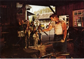
Heritage Village Museum blacksmith shop postcard
https://search.heritageburnaby.ca/link/museumdescription15413
- Repository
- Burnaby Village Museum
- Date
- Dec. 1984
- Collection/Fonds
- Donald Copan collection
- Description Level
- Item
- Physical Description
- 1 photograph : col. postcard ; 10.5 x 15 cm
- Scope and Content
- Photographic postcard with photograph of a blacksmith working in the blacksmith shop inside of Heritage Village Museum (now Burnaby Village Museum) while a group of visitors look on. The postcard is from Heritage Village Museum and is addressed to "D & B Copan..." with an invitation for "Surveying …
- Repository
- Burnaby Village Museum
- Collection/Fonds
- Donald Copan collection
- Series
- B.C. Summer Games series
- Description Level
- Item
- Physical Description
- 1 photograph : col. postcard ; 10.5 x 15 cm
- Scope and Content
- Photographic postcard with photograph of a blacksmith working in the blacksmith shop inside of Heritage Village Museum (now Burnaby Village Museum) while a group of visitors look on. The postcard is from Heritage Village Museum and is addressed to "D & B Copan..." with an invitation for "Surveying Weekend September 29 & 30 / Come to the Museum on Saturday or Sunday to see demonstratons of early surveying equipment, lectures, and interesting personalities from this field..."
- Subjects
- Businesses - Blacksmithing
- Names
- Burnaby Village Museum
- Accession Code
- BV021.4.23
- Access Restriction
- No restrictions
- Reproduction Restriction
- No known restrictions
- Date
- Dec. 1984
- Media Type
- Photograph
- Scan Resolution
- 600
- Scan Date
- April 1, 2021
- Scale
- 100
- Notes
- Title based on contents of photograph
Images


Subdivision and survey plans series
https://search.heritageburnaby.ca/link/museumdescription18948
- Repository
- Burnaby Village Museum
- Date
- [1890]-1932
- Collection/Fonds
- Ronald G. Scobbie collection
- Description Level
- Series
- Physical Description
- 25 plans + 2 cm of textual records
- Scope and Content
- Series consists of surveying and subdivision records created by Provincial Land Surveyors Albert J. Hill, Geoffrey K. Burnett and Donald Johnson McGugan. Records include subdivision and survey plans of areas in New Westminster District Group 1 along with surveying plans and correspondence regarding…
- Repository
- Burnaby Village Museum
- Collection/Fonds
- Ronald G. Scobbie collection
- Description Level
- Series
- Physical Description
- 25 plans + 2 cm of textual records
- Scope and Content
- Series consists of surveying and subdivision records created by Provincial Land Surveyors Albert J. Hill, Geoffrey K. Burnett and Donald Johnson McGugan. Records include subdivision and survey plans of areas in New Westminster District Group 1 along with surveying plans and correspondence regarding North Road and a survey plan of "Burnaby Park track".
- Accession Code
- HV984.57
- BV003.83
- Date
- [1890]-1932
- Media Type
- Cartographic Material
- Textual Record
- Notes
- Title based on contents of series
Surveyor field book 32
https://search.heritageburnaby.ca/link/museumdescription19633
- Repository
- Burnaby Village Museum
- Date
- 1913-1929, predominant 1913
- Collection/Fonds
- Burnaby Village Museum Map collection
- Description Level
- Item
- Physical Description
- 1 notebook
- Scope and Content
- Item consists of a field notebook with surveyor's field notes created by B.C. Land Surveyor, Walter Wilkie. Field notes include pertinent information, calculations, sketches and observations including geographic areas in Burnaby (D.L.86 and D.L. 136); Surrey (Twp 1, Twp 7); Maple Ridge (Twp 12); La…
- Repository
- Burnaby Village Museum
- Collection/Fonds
- Burnaby Village Museum Map collection
- Description Level
- Item
- Physical Description
- 1 notebook
- Material Details
- Yellow leather hardcover book with inscription on cover "FIELD BOOK";Technical Manufacturing & Supply Co., Vancouver, B.C.
- Annotation in black ink on front cover reads: "32"
- Includes reference tables at front and back of notebook for surveying computations.
- Scope and Content
- Item consists of a field notebook with surveyor's field notes created by B.C. Land Surveyor, Walter Wilkie. Field notes include pertinent information, calculations, sketches and observations including geographic areas in Burnaby (D.L.86 and D.L. 136); Surrey (Twp 1, Twp 7); Maple Ridge (Twp 12); Langley (Twp 10, Twp 11 and Lots 36, 304, 308, 309, 312); Dewdney (D.L. 484 Group 1) and Coquitlam (D.L.366 Group 1). Notebook includes a handwritten index of surveying content, on the last few pages at back of book.
- Creator
- Wilkie, "Walter" Gerald
- Subjects
- Occupations - Land Surveyors
- Accession Code
- HV977.128.1
- Access Restriction
- No restrictions
- Reproduction Restriction
- No known restrictions
- Date
- 1913-1929, predominant 1913
- Media Type
- Textual Record
- Notes
- Title based on contents of item
![Inside of the surveyor's office, [198_] thumbnail](/media/hpo/_Data/_BVM_Images/2020/2020_0005_0665_001.jpg?width=280)
Inside of the surveyor's office
https://search.heritageburnaby.ca/link/museumdescription13035
- Repository
- Burnaby Village Museum
- Date
- [198_]
- Collection/Fonds
- Century Park Museum Association fonds
- Description Level
- Item
- Physical Description
- 1 photograph : col. ; 20 x 25 cm
- Scope and Content
- Photograph of the interior of the "Surveyor's Office" inside of the Heritage Village Museum. A long wood table, wood stove, roll top desk, survey plans and surveying equipment are visible.
- Repository
- Burnaby Village Museum
- Collection/Fonds
- Century Park Museum Association fonds
- Description Level
- Item
- Physical Description
- 1 photograph : col. ; 20 x 25 cm
- Scope and Content
- Photograph of the interior of the "Surveyor's Office" inside of the Heritage Village Museum. A long wood table, wood stove, roll top desk, survey plans and surveying equipment are visible.
- Subjects
- Occupations - Land Surveyors
- Names
- Burnaby Village Museum
- Accession Code
- BV020.5.665
- Access Restriction
- No restrictions
- Reproduction Restriction
- No known restrictions
- Date
- [198_]
- Media Type
- Photograph
- Related Material
- See also photograph BV020.5.664
- Scan Resolution
- 600
- Scan Date
- 1-May-20
- Scale
- 100
- Notes
- Title based on contents of photograph
Images
![Inside of the surveyor's office, [198_] thumbnail](/media/hpo/_Data/_BVM_Images/2020/2020_0005_0665_001.jpg)

Interior of land surveyor's office at Burnaby Village Museum
https://search.heritageburnaby.ca/link/museumdescription13768
- Repository
- Burnaby Village Museum
- Date
- Sept. 1987
- Collection/Fonds
- Century Park Museum Association fonds
- Description Level
- Item
- Physical Description
- 1 photograph : col. ; 9 x 12.5 cm
- Scope and Content
- Photograph of the interior of the land surveyor's office at Burnaby Village Museum. Office is furnished with a roll top desk, maps and plans and various surveying tools.
- Repository
- Burnaby Village Museum
- Collection/Fonds
- Century Park Museum Association fonds
- Description Level
- Item
- Physical Description
- 1 photograph : col. ; 9 x 12.5 cm
- Scope and Content
- Photograph of the interior of the land surveyor's office at Burnaby Village Museum. Office is furnished with a roll top desk, maps and plans and various surveying tools.
- Subjects
- Occupations - Land Surveyors
- Names
- Burnaby Village Museum
- Geographic Access
- Deer Lake Avenue
- Accession Code
- BV020.5.958
- Access Restriction
- No restrictions
- Reproduction Restriction
- No known restrictions
- Date
- Sept. 1987
- Media Type
- Photograph
- Scan Resolution
- 600
- Scan Date
- 22-Sep-2020
- Scale
- 100
- Notes
- Title based on contents of photograph
Images

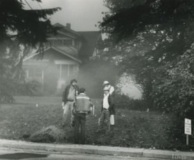
Lillian Mann's property
https://search.heritageburnaby.ca/link/archivedescription46229
- Repository
- City of Burnaby Archives
- Date
- March 1982
- Collection/Fonds
- Columbian Newspaper collection
- Description Level
- Item
- Physical Description
- 1 photograph : b&w ; 19.5 x 23.5 cm
- Scope and Content
- Photograph of a municipal crew surveying Lillian Mann's property.
- Repository
- City of Burnaby Archives
- Date
- March 1982
- Collection/Fonds
- Columbian Newspaper collection
- Physical Description
- 1 photograph : b&w ; 19.5 x 23.5 cm
- Description Level
- Item
- Record No.
- 480-1117
- Access Restriction
- No restrictions
- Reproduction Restriction
- No restrictions
- Accession Number
- 2003-02
- Scope and Content
- Photograph of a municipal crew surveying Lillian Mann's property.
- Subjects
- Occupations - Civic Workers
- Media Type
- Photograph
- Photographer
- King, Basil
- Notes
- Title based on contents of photograph
- Quote originally appeared in the Columbian newspaper in march of 1982, and was a quote from municipal engineer Ernie Olson
- Geographic Access
- Cameron Street
- Historic Neighbourhood
- Burquitlam (Historic Neighbourhood)
- Planning Study Area
- Lyndhurst Area
Images
School and church plans series
https://search.heritageburnaby.ca/link/museumdescription18949
- Repository
- Burnaby Village Museum
- Date
- [1910]-1932
- Collection/Fonds
- Ronald G. Scobbie collection
- Description Level
- Series
- Physical Description
- 30 plans + 2 architectural drawings + graphic materials + textual records
- Scope and Content
- Series consists of surveying plans of schools and churches within the Corporation of the District of Burnaby along with graphic material relating to the division of tax spending by the Corporation of the District of Burnaby.
- Repository
- Burnaby Village Museum
- Collection/Fonds
- Ronald G. Scobbie collection
- Description Level
- Series
- Physical Description
- 30 plans + 2 architectural drawings + graphic materials + textual records
- Scope and Content
- Series consists of surveying plans of schools and churches within the Corporation of the District of Burnaby along with graphic material relating to the division of tax spending by the Corporation of the District of Burnaby.
- Accession Code
- BV003.83
- Date
- [1910]-1932
- Notes
- Title based on contents of series
Resurvey of the Municipality of Burnaby - Miscellaneous
https://search.heritageburnaby.ca/link/archivedescription743
- Repository
- City of Burnaby Archives
- Date
- 1913-1926
- Collection/Fonds
- City Council and Office of the City Clerk fonds
- Description Level
- File
- Physical Description
- 4 folders textual records and cartographic material
- Scope and Content
- File contains correspondence regarding the re-survey of the Municipality of Burnaby. As well, file includes "Report on the Special Survey of Burnaby up to June 1, 1915" which includes a linen plan of "Complete Special Survey" and "Block Outline Special Survey." Also included are lists of property…
- Repository
- City of Burnaby Archives
- Date
- 1913-1926
- Collection/Fonds
- City Council and Office of the City Clerk fonds
- Physical Description
- 4 folders textual records and cartographic material
- Description Level
- File
- Record No.
- 2476
- Accession Number
- 2001-02
- Scope and Content
- File contains correspondence regarding the re-survey of the Municipality of Burnaby. As well, file includes "Report on the Special Survey of Burnaby up to June 1, 1915" which includes a linen plan of "Complete Special Survey" and "Block Outline Special Survey." Also included are lists of property owners.
- Media Type
- Textual Record
- Cartographic Material
- Notes
- For related records see also 7-2-4-14 and 7-2-4-15, and 7-2-5-1 and 7-2-5-3. Plans/maps are located in file and have not been moved to map case.
![Survey and Subdivision plans in New Westminster District Group 1 – Burnaby, Port Moody, [1862-1908] thumbnail](/media/hpo/_Data/_BVM_Cartographic_Material/1977/1977_0093_0026a_001.jpg?width=280)
Survey and Subdivision plans in New Westminster District Group 1 – Burnaby, Port Moody
https://search.heritageburnaby.ca/link/museumdescription6995
- Repository
- Burnaby Village Museum
- Date
- [1862-1908]
- Collection/Fonds
- Burnaby Village Museum Map collection
- Description Level
- File
- Physical Description
- 9 plans : 6 plans : black ink on paper ; 57 x 36.5 cm or smaller + 1 plan : black ink and grahite on paper ; 46.5 x 49 cm + 1 plan : blueprint on paper ; 15.5 x 19.5 cm + cm + 1 plan : graphite on paper ; 25 x 17 cm ; mounted on both sides of board 76 x 102 cm
- Scope and Content
- Item consists of a large board of four New Westminster District subdivision plans mounted on one side and five New Westminster District subdivision plans mounted on the other side. Side A: 1. "Plan / of Subdivision / of a Portion / of / Lot 87 / Group One / New Westminster District / Scale 4 chs…
- Repository
- Burnaby Village Museum
- Collection/Fonds
- Burnaby Village Museum Map collection
- Description Level
- File
- Physical Description
- 9 plans : 6 plans : black ink on paper ; 57 x 36.5 cm or smaller + 1 plan : black ink and grahite on paper ; 46.5 x 49 cm + 1 plan : blueprint on paper ; 15.5 x 19.5 cm + cm + 1 plan : graphite on paper ; 25 x 17 cm ; mounted on both sides of board 76 x 102 cm
- Material Details
- Scales [between 1:792 and 1:3600]
- Index number on edge of board reads: "26"
- Scope and Content
- Item consists of a large board of four New Westminster District subdivision plans mounted on one side and five New Westminster District subdivision plans mounted on the other side. Side A: 1. "Plan / of Subdivision / of a Portion / of / Lot 87 / Group One / New Westminster District / Scale 4 chs = 1 in". Plan is stamped: "Albert J. Hill, Civil Engineer / and / Provincial Land Surveyor, / New Westminster, / B.C." and intialed by: "RB" [sic] (in blue pencil crayon). Names two of the subdivisons of District Lot 87 are identified as, "L.E. Sprott" and "John Ledger". (Geographic location: Burnaby) 2. "Plan of Subdivision / of / Portions of / Lot 136, 131 and Lots 44 and 78 Gr.1 / New Westminster District / Scale 300 ft = 1 inch". Annotation above title reads: "No. 901 / Deposited in Land Registry Office / New Westminster / Aug. 19th 1905 / Charles S. Keith D. Reg." Annotations and signatures at bottom of plan read: "I, William Nelson Draper, / W.H.R. Collister / Charles E. Perkins / E.B. Morgan / make / Surveys / correct / representation / upon / the / Land Registry Act / (sgd) W.N. Draper, P.L.S.". Plan includes a handwritten title: "Lots 136, 131, 44 & 78" and is initialed: "RB" [sic] (in blue pencil crayon) (Geographic location: Burnaby) 3. "Survey / of / a Portion / of / Lot 95, Gr.1 / Scale 1 ch = 1in." Plan is stamped: "Albert J. Hill, Civil Engineer / and / Provincial Land Surveyor, / New Westminster, / B.C." and is initialed : "RB" [sic] (in blue pencil crayon) (Geographic location: Burnaby) 4. Blueprint plan of "Lot 396. Group One." with Scale : 3 chs = 1 in. A two acre portion of District Lot 396 is filled in with red ink." Plan is signed by "Albert J. Hill / B.C.L.S." (Geographic location: Port Moody) Side B: 1. Plan titled "District Lot 92 / Burnaby / Municipality / for sale by / Mahon / McFarland & / Mahon Ltd. / Vancouver, B.C. / Scale : 4 chains to one inch". District Lot 92 is subdivided into 161 lots and identifies roads: Norwich Road, Pole Line Road, Oakland Road, Stanley Road, Burford Road, Dalhousie Road, Brantford Road, Colborne Road, Roberts Road, Vancouver & Westminster Road, B.C. Electric Railway, Gilley Stn. and Burnaby (Power House). The bottom of the plan reads: "G.S. Dawson, P.LS. Vancouver, B.C." (Geographic location: Burnaby) 2. "Plan / of Subdivision / of a Portion / of / Lot 29 / Group 1 / New Westminster District / Scale 2 chs = 1 in". Plan is stamped: "Albert J. Hill, Civil Engineer / and / Provincial Land Surveyor, / New Westminster, / B.C." and is initialed by: "RB" [sic] (in blue pencil crayon) (Geographic location: Burnaby) 3. Small handrawn plan (no title) identifying "Lot 84 / Hydes, Claim" at the centre surrounded by lots and features identified as: "Lot 85", "Lot 93", "Lot 94", "Lot 32", "Lot 82", "Lot 83", "Lot 79", "swamp" and a "Small Lake" (Burnaby Lake). Identifying marks in the right corner of the plan read: "Page 13 / Surveyed by G. Turner / May 62". Plan also includes surveyor's bearing measurements and trails to "Small Lake" (Burnaby Lake). (Geographic location: Burnaby) 4. Untitled plan showing District Lots west of North Road and north of Burnaby Lake including: Lots 2, 4, 6, 8, 15, 10, 56, 148, 57, 58, 40. and Lots 3, 5, 7 east of North Road (Coquitlam). Lots in Burnaby are identifed for timber including: "Heavily Timbered" (Lot 57), " "Some Fir and Cedar" (Lot 40), "Splendid Fir and Cedar" (Lot 143), "Heavy Fir etc" (Lots 143 and 148), " "Fine Cedar" (Lot 15), "Rough Light Timber" (Lot 56). Other features identified at the lower portion of the plan include "Burnaby Lake" and "Brunette River". (Geographic location: Burnaby) 5. Untitled plan drawn in graphite showing sections of District Lot 85 south of Burnaby Lake and north of Hazsard Road. Plan is signed: "Albert J. Hill / B.C.L.S." and dated "12/26/08". Plan is initialed by: "RB" [sic] (in blue pencil crayon) (Geographic location: Burnaby)
- Publisher
- Mahon, McFarland & Mahon Ltd
- Accession Code
- HV977.93.26
- Access Restriction
- No restrictions
- Reproduction Restriction
- No known restrictions
- Date
- [1862-1908]
- Media Type
- Cartographic Material
- Historic Neighbourhood
- Burnaby Lake (Historic Neighbourhood)
- Burquitlam (Historic Neighbourhood)
- Planning Study Area
- Burnaby Lake Area
- Scan Resolution
- 300
- Scale
- 72
- Notes
- Title based on contents of file
- Scale is measured in chains and feet. (One chain equals 792 inches)
- The term "Lot" can also refer to a "District Lot”
Images
![Survey and Subdivision plans in New Westminster District Group 1 – Burnaby, Port Moody, [1862-1908] thumbnail](/media/hpo/_Data/_BVM_Cartographic_Material/1977/1977_0093_0026a_001.jpg)


Burnaby Heights Community Survey
https://search.heritageburnaby.ca/link/archivedescription58312
- Repository
- City of Burnaby Archives
- Date
- 1986-1989
- Collection/Fonds
- Burnaby Historical Society fonds
- Description Level
- File
- Physical Description
- 1 file of textual records
- Scope and Content
- File consists of the Burnaby Heights Community Survey sponsored by the Gilmore Community Centre and related newspaper clippings.
- Repository
- City of Burnaby Archives
- Date
- 1986-1989
- Collection/Fonds
- Burnaby Historical Society fonds
- Subseries
- Evelyn Salisbury subseries
- Physical Description
- 1 file of textual records
- Description Level
- File
- Record No.
- MSS061-109
- Access Restriction
- In Archives only
- Accession Number
- BHS1991-24
- Scope and Content
- File consists of the Burnaby Heights Community Survey sponsored by the Gilmore Community Centre and related newspaper clippings.
- Media Type
- Textual Record
- Notes
- Title based on contents of file
Letter re Special Survey of District Lots 9, 55, 106 and 107
https://search.heritageburnaby.ca/link/museumdescription11144
- Repository
- Burnaby Village Museum
- Date
- December 1927
- Collection/Fonds
- Ronald G. Scobbie collection
- Description Level
- Item
- Physical Description
- 1 p. of textual records
- Scope and Content
- Item consists of a letter dated 13th December 1927 with letterhead "McQuarrie, Whiteside & Duncan / Barristers & Solicitors", "New Westminster Office / Westminster Trust Building / Mission City Office / Catherwood Building / New Westminster, B.C.."; addressee "Messrs. Burnett & McGugan, Surveyors /…
- Repository
- Burnaby Village Museum
- Collection/Fonds
- Ronald G. Scobbie collection
- Description Level
- Item
- Physical Description
- 1 p. of textual records
- Scope and Content
- Item consists of a letter dated 13th December 1927 with letterhead "McQuarrie, Whiteside & Duncan / Barristers & Solicitors", "New Westminster Office / Westminster Trust Building / Mission City Office / Catherwood Building / New Westminster, B.C.."; addressee "Messrs. Burnett & McGugan, Surveyors / 30 McKenzie Street, CITY" "ATTENTION MR. BURNETT."; "Re: Special Survey of District Lots 9, 55, 106 and 107. Group 1, New Westminster District, District of Coquitlam".
- Accession Code
- BV003.83.23
- Access Restriction
- No restrictions
- Reproduction Restriction
- No known restrictions
- Date
- December 1927
- Media Type
- Textual Record
- Notes
- Title based on contents of item
Letter re Special Survey of District Lots 9, 55 (or 54) 106 and 107
https://search.heritageburnaby.ca/link/museumdescription11146
- Repository
- Burnaby Village Museum
- Date
- Dec. 5, 1927
- Collection/Fonds
- Ronald G. Scobbie collection
- Description Level
- Item
- Physical Description
- 1 p. of textual records
- Scope and Content
- Item consists of a typewritten letter dated December 5, 1927, addressee "R.C. McDonald, Esq., New Westminster, B.C.". "Re. Special Survey of District Lots 9, 55 (or 54) 106 and 107, Group 1, N.W.D." from Burnett & McGguan.
- Repository
- Burnaby Village Museum
- Collection/Fonds
- Ronald G. Scobbie collection
- Description Level
- Item
- Physical Description
- 1 p. of textual records
- Scope and Content
- Item consists of a typewritten letter dated December 5, 1927, addressee "R.C. McDonald, Esq., New Westminster, B.C.". "Re. Special Survey of District Lots 9, 55 (or 54) 106 and 107, Group 1, N.W.D." from Burnett & McGguan.
- Accession Code
- BV003.83.25
- Access Restriction
- No restrictions
- Reproduction Restriction
- No known restrictions
- Date
- Dec. 5, 1927
- Media Type
- Textual Record
- Notes
- Title based on contents of item
Letter re survey of District Lots 9, 55, 106 & 107 Group 1, New Westminster District
https://search.heritageburnaby.ca/link/museumdescription11154
- Repository
- Burnaby Village Museum
- Date
- 1927
- Collection/Fonds
- Ronald G. Scobbie collection
- Description Level
- File
- Physical Description
- 4 p. of textual records
- Scope and Content
- File consists of two typewritten letters. A three page carbon copy from Burnett & McGugan, dated 16th April 1927 Re: "DL 9-54-106-107, Gp. 1" is addressed to "R. Newman, Esq., / Corporation of Coquitlam, / Maillardville, BC". One page letter dated September 14th, 1927, includes the letterhead of "C…
- Repository
- Burnaby Village Museum
- Collection/Fonds
- Ronald G. Scobbie collection
- Description Level
- File
- Physical Description
- 4 p. of textual records
- Scope and Content
- File consists of two typewritten letters. A three page carbon copy from Burnett & McGugan, dated 16th April 1927 Re: "DL 9-54-106-107, Gp. 1" is addressed to "R. Newman, Esq., / Corporation of Coquitlam, / Maillardville, BC". One page letter dated September 14th, 1927, includes the letterhead of "Corporation of the District of Coquitlam / Muncipal Hall / Maillardville, BC" is addressed to "Messrs. Burnett & McGugan, / Engineers..." regarding a request for a "preliminary survey of District Lots 9, 55, 106 & 107". The letter is signed by Clerk "Hobart Newman".
- Accession Code
- BV003.83.33
- Access Restriction
- No restrictions
- Reproduction Restriction
- No known restrictions
- Date
- 1927
- Media Type
- Textual Record
- Notes
- Title based on contents of file
- Note in pencil on letter dated April 16, 1927 reads: "File under & Index / {DL 9, 54, 106, 107} Group 1"
- Note in pencil on verso of letter dated September 14th, 1927 reads: "Env. 3468"

Municipality of Burnaby - Volume XVI and Volume XVII
https://search.heritageburnaby.ca/link/museumdescription8684
- Repository
- Burnaby Village Museum
- Date
- May 1927
- Collection/Fonds
- Burnaby Village Museum Map collection
- Description Level
- File
- Physical Description
- 4 plans on 4 sheets : col. lithographic prints ; 63.5 x 53.5 cm folded to 53 x 31.5 cm
- Scope and Content
- File consists of four pages of plans removed from a bound book containing a series of fire insurance plans of the Municipality of Burnaby. Page "D" is titled: "GREATER VANCOUVER B.C. / VOLUME XVI / Surveyed _ May 1927 / MUNICIPALITY OF / BURNABY / PLAN DEPT. FIRE BRANCH _ B.C. INSURANCE UNDERWRITE…
- Repository
- Burnaby Village Museum
- Collection/Fonds
- Burnaby Village Museum Map collection
- Description Level
- File
- Physical Description
- 4 plans on 4 sheets : col. lithographic prints ; 63.5 x 53.5 cm folded to 53 x 31.5 cm
- Material Details
- Scale [1:1200] and [1:6000]
- Scope and Content
- File consists of four pages of plans removed from a bound book containing a series of fire insurance plans of the Municipality of Burnaby. Page "D" is titled: "GREATER VANCOUVER B.C. / VOLUME XVI / Surveyed _ May 1927 / MUNICIPALITY OF / BURNABY / PLAN DEPT. FIRE BRANCH _ B.C. INSURANCE UNDERWRITERS ASSN." / KEY PLAN". Plans covered in this "Key Plan" are numbered 1601 to 1626, 1632 and 1651 covering District Lots: 15; 31; 100 to 102; 114; 141 to 144; 147 and 148; 209 to 214. Plan "E" is part of "GREATER VANCOUVER B.C. / VOLUME XVII / Municipality of Burnaby / May 1927" and covers plans: 1701 to 1705; 1711 to 1715; 1723 to 1727; 1729 to 1733; 1737 to 1742 and District Lots: 68 to 74; 80 to 84; 32 to 35 and 38 to 39. Plan marked "F" is a key plan titled: "GREATER VANCOUVER B.C. / VOLUME XVII / Surveyed _ May 1927 / MUNICIPALITY OF / BURNABY and covers plans: 1706 to 1710; 1716 to 1722; 1734 and 1735; 1743 to 1752 and District Lots: 42 to 44; 59; 75 to 80; 83 to 87; 89 to 93 and 130. Plan "1729" is part of "GREATER VANCOUVER B.C. / VOLUME XVII / Municipality of Burnaby / May 1927" and covers District Lots 34 and 35.
- Responsibility
- British Columbia Underwriters' Association
- Accession Code
- HV972.111.6
- Access Restriction
- No restrictions
- Reproduction Restriction
- May be restricted by third party rights
- Date
- May 1927
- Media Type
- Cartographic Material
- Historic Neighbourhood
- Barnet (Historic Neighbourhood)
- Burquitlam (Historic Neighbourhood)
- Central Park (Historic Neighbourhood)
- Burnaby Lake (Historic Neighbourhood)
- Broadview (Historic Neighbourhood)
- Planning Study Area
- Burnaby Mountain Area
- Lyndhurst Area
- Lake City Area
- Cascade-Schou Area
- Garden Village Area
- Douglas-Gilpin Area
- Oakalla Area
- Scan Resolution
- 400
- Scan Date
- 2021-11-18
- Notes
- Title based on content of plans
- See also BV987.1.70d for revised versions of plans
- Scale is measured 1 inch = 500 feet


