Narrow Results By
Subject
- Advertising Medium - Signs and Signboards 1
- Aerial Photographs 5
- Animals 2
- Animals - Birds 5
- Animals - Dogs 1
- Buildings - Civic 2
- Buildings - Recreational 7
- Buildings - Residential - Houses 1
- Construction - Road Construction 6
- Education 1
- Environmental Issues 1
- Environmental Issues - Environmental Protection 1
Person / Organization
- British Columbia Electric Railway Company 1
- British Columbia Hydro and Power Authority 1
- Burnaby Central Secondary School 8
- Burnaby Lake Nature House 4
- Burnaby Lake Rowing Pavilion 1
- Burnaby School Trustees 4
- Burnaby Village Museum 1
- Ceperley, H.T. 2
- Chalk, John 4
- Chalk, Timothy 4
- City of Burnaby 1
- Freebairn-Smith, Mary Elizabeth "Betty" Peers 1

Nature House
https://search.heritageburnaby.ca/link/archivedescription93628
- Repository
- City of Burnaby Archives
- Date
- October 22, 1977
- Collection/Fonds
- Burnaby Public Library Contemporary Visual Archive Project
- Description Level
- Item
- Physical Description
- 1 photograph : b&w ; 12.5 x 17.5 cm
- Scope and Content
- Photograph of the Burnaby Lake Nature House at 4519 Piper Avenue in Burnaby Lake Regional Park. The photograph is taken facing southwest. The Nature House was built in 1940. The sign for the Nature House is just visible on the left side of the photograph, and canoes are stacked outside beside the b…
- Repository
- City of Burnaby Archives
- Date
- October 22, 1977
- Collection/Fonds
- Burnaby Public Library Contemporary Visual Archive Project
- Physical Description
- 1 photograph : b&w ; 12.5 x 17.5 cm
- Description Level
- Item
- Record No.
- 556-585
- Access Restriction
- No restrictions
- Reproduction Restriction
- Reproduce for fair dealing purposes only
- Accession Number
- 2017-57
- Scope and Content
- Photograph of the Burnaby Lake Nature House at 4519 Piper Avenue in Burnaby Lake Regional Park. The photograph is taken facing southwest. The Nature House was built in 1940. The sign for the Nature House is just visible on the left side of the photograph, and canoes are stacked outside beside the building.
- Media Type
- Photograph
- Photographer
- Surridge, Jack
- Notes
- Title taken from project information form
- Accompanied by a project information form and 1 photograph (b&w negative ; 9.5 x 12.5 cm)
- BPL no. 34
- Geographic Access
- Burnaby Lake Regional Nature Park
- Street Address
- 4519 Piper Avenue
- Historic Neighbourhood
- Lozells (Historic Neighbourhood)
- Planning Study Area
- Burnaby Lake Area
Images

Nature Trail
https://search.heritageburnaby.ca/link/archivedescription79895
- Repository
- City of Burnaby Archives
- Date
- September, 1976
- Collection/Fonds
- Burnaby Public Library Contemporary Visual Archive Project
- Description Level
- Item
- Physical Description
- 1 photograph : b&w ; 11 x 16 cm mounted on cardboard
- Scope and Content
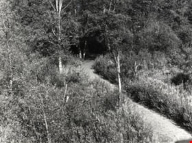
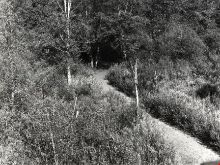
- Photograph shows a section of the nature trail near Burnaby Lake.
- Repository
- City of Burnaby Archives
- Date
- September, 1976
- Collection/Fonds
- Burnaby Public Library Contemporary Visual Archive Project
- Physical Description
- 1 photograph : b&w ; 11 x 16 cm mounted on cardboard
- Description Level
- Item
- Record No.
- 556-491
- Access Restriction
- No restrictions
- Reproduction Restriction
- Reproduce for fair dealing purposes only
- Accession Number
- 2013-13
- Scope and Content
- Photograph shows a section of the nature trail near Burnaby Lake.
- Media Type
- Photograph
- Photographer
- McCarron, John
- Notes
- Scope note taken directly from BPL photograph description.
- 1 b&w copy negative : 10 x 12.5 cm accompanying
- Geographic Access
- Burnaby Lake
- Historic Neighbourhood
- Burnaby Lake (Historic Neighbourhood)
- Planning Study Area
- Burnaby Lake Area
Images
Nature Trail
https://search.heritageburnaby.ca/link/archivedescription79898
- Repository
- City of Burnaby Archives
- Date
- September, 1976
- Collection/Fonds
- Burnaby Public Library Contemporary Visual Archive Project
- Description Level
- Item
- Physical Description
- 1 photograph : b&w ; 11 x 16 cm mounted on cardboard
- Scope and Content
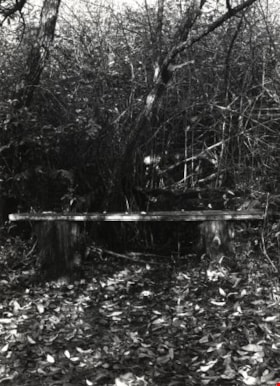
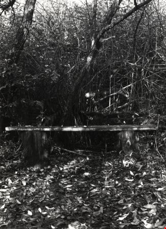
- Photograph shows a bench along the Burnaby Lake Nature Trail.
- Repository
- City of Burnaby Archives
- Date
- September, 1976
- Collection/Fonds
- Burnaby Public Library Contemporary Visual Archive Project
- Physical Description
- 1 photograph : b&w ; 11 x 16 cm mounted on cardboard
- Description Level
- Item
- Record No.
- 556-492
- Access Restriction
- No restrictions
- Reproduction Restriction
- Reproduce for fair dealing purposes only
- Accession Number
- 2013-13
- Scope and Content
- Photograph shows a bench along the Burnaby Lake Nature Trail.
- Media Type
- Photograph
- Photographer
- McCarron, John
- Notes
- Scope note taken directly from BPL photograph description.
- 1 b&w copy negative : 10 x 12.5 cm accompanying
- Geographic Access
- Burnaby Lake
- Historic Neighbourhood
- Burnaby Lake (Historic Neighbourhood)
- Planning Study Area
- Burnaby Lake Area
Images
Nature Trail
https://search.heritageburnaby.ca/link/archivedescription79903
- Repository
- City of Burnaby Archives
- Date
- September, 1976
- Collection/Fonds
- Burnaby Public Library Contemporary Visual Archive Project
- Description Level
- Item
- Physical Description
- 1 photograph : b&w ; 11 x 16 cm mounted on cardboard
- Scope and Content
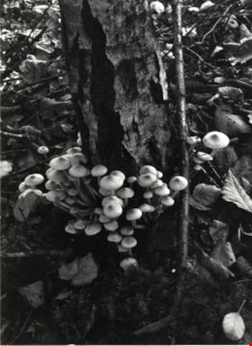
- Photograph shows mushrooms growing on an old stump along the Burnaby Lake Nature trail.
- Repository
- City of Burnaby Archives
- Date
- September, 1976
- Collection/Fonds
- Burnaby Public Library Contemporary Visual Archive Project
- Physical Description
- 1 photograph : b&w ; 11 x 16 cm mounted on cardboard
- Description Level
- Item
- Record No.
- 556-493
- Access Restriction
- No restrictions
- Reproduction Restriction
- Reproduce for fair dealing purposes only
- Accession Number
- 2013-13
- Scope and Content
- Photograph shows mushrooms growing on an old stump along the Burnaby Lake Nature trail.
- Media Type
- Photograph
- Photographer
- McCarron, John
- Notes
- Scope note taken directly from BPL photograph description.
- 1 b&w copy negative : 10 x 12.5 cm accompanying
- Geographic Access
- Burnaby Lake
- Historic Neighbourhood
- Burnaby Lake (Historic Neighbourhood)
- Planning Study Area
- Burnaby Lake Area
Images


Nature Trail Sign
https://search.heritageburnaby.ca/link/archivedescription79889
- Repository
- City of Burnaby Archives
- Date
- September 23, 1976
- Collection/Fonds
- Burnaby Public Library Contemporary Visual Archive Project
- Description Level
- Item
- Physical Description
- 1 photograph : b&w ; 11 x 16 cm mounted on cardboard
- Scope and Content
- Photograph shows a sign commemorating the creation of a nature trail at Burnaby Lake. The trail was developed by a Local Initiatives Project in 1973.
- Repository
- City of Burnaby Archives
- Date
- September 23, 1976
- Collection/Fonds
- Burnaby Public Library Contemporary Visual Archive Project
- Physical Description
- 1 photograph : b&w ; 11 x 16 cm mounted on cardboard
- Description Level
- Item
- Record No.
- 556-490
- Access Restriction
- No restrictions
- Reproduction Restriction
- Reproduce for fair dealing purposes only
- Accession Number
- 2013-13
- Scope and Content
- Photograph shows a sign commemorating the creation of a nature trail at Burnaby Lake. The trail was developed by a Local Initiatives Project in 1973.
- Media Type
- Photograph
- Photographer
- Norton, Paul
- Notes
- Scope note taken directly from BPL photograph description.
- 1 b&w copy negative : 10 x 12.5 cm accompanying
- Geographic Access
- Burnaby Lake
- Historic Neighbourhood
- Burnaby Lake (Historic Neighbourhood)
- Planning Study Area
- Burnaby Lake Area
Images

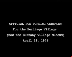
Official Sod Turning Ceremony for Heritage Village
https://search.heritageburnaby.ca/link/museumdescription9776
- Repository
- Burnaby Village Museum
- Date
- April 11 1971 (date of original), digitized in 2011
- Collection/Fonds
- Burnaby Centennial '71 Committee collection
- Description Level
- Item
- Physical Description
- 1 video recording (mp4) (3 min., 11 sec.) : digital, 29 fps, b&w, sd., stereo
- Scope and Content
- Film of Vintage car parade ending with the sod turning ceremony at Heritage Park Museum. CBC news item April 11, 1971.
- Repository
- Burnaby Village Museum
- Collection/Fonds
- Burnaby Centennial '71 Committee collection
- Description Level
- Item
- Physical Description
- 1 video recording (mp4) (3 min., 11 sec.) : digital, 29 fps, b&w, sd., stereo
- Material Details
- Script read by Mike Dobson
- Film footage was edited and digitized by Oliver Glaser at Newsreel Productions
- Audio production by emBall Productions
- Scope and Content
- Film of Vintage car parade ending with the sod turning ceremony at Heritage Park Museum. CBC news item April 11, 1971.
- History
- This footage was originally shot in 16 mm, on Sunday, April 11, 1971, and broadcast on CBC television. The original footage was silent: when it was broadcast, a news announcer read from a script to describe the events. In 2011, the footage was digitized. The original script was read by an actor, recorded, and added to the digitized footage to create this film.
- Subjects
- Events - Parades
- Names
- Burnaby Village Museum
- Responsibility
- Canadian Broadcasting Corporation
- Geographic Access
- Deer Lake Avenue
- Accession Code
- BV018.42.1
- Access Restriction
- No restrictions
- Reproduction Restriction
- May be restricted by third party rights
- Date
- April 11 1971 (date of original), digitized in 2011
- Media Type
- Moving Images
- Historic Neighbourhood
- Burnaby Lake (Historic Neighbourhood)
- Planning Study Area
- Burnaby Lake Area
- Notes
- Transcribed title
- BV020.5.708 is the original 16mm silent film that this film was created from
Images
Video
Official Sod Turning Ceremony for Heritage Village, April 11 1971 (date of original), digitized in 2011
Official Sod Turning Ceremony for Heritage Village, April 11 1971 (date of original), digitized in 2011
https://search.heritageburnaby.ca/media/hpo/_Data/_BVM_Moving_Images/2018_0042_0001_001.mp4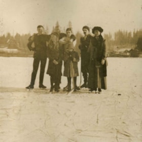
Peers family at Deer Lake
https://search.heritageburnaby.ca/link/archivedescription66272
- Repository
- City of Burnaby Archives
- Date
- 1915
- Collection/Fonds
- Peers Family and Hill Family fonds
- Description Level
- Item
- Physical Description
- 1 photograph
- Scope and Content
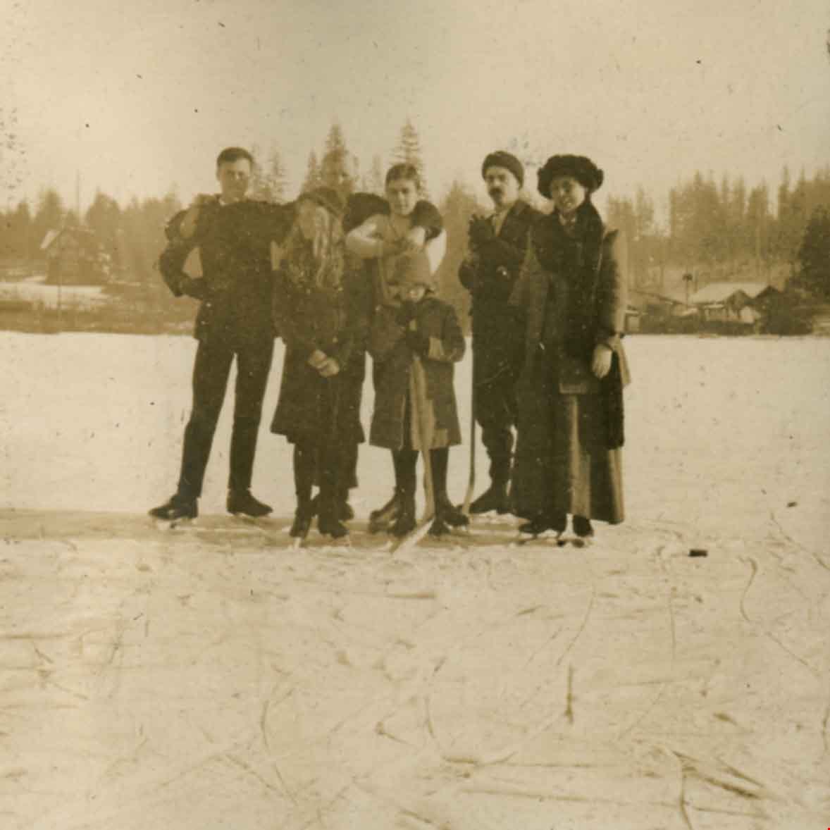
- Photograph shows members of the Peers family and friends skating on Deer Lake. Identified, back row (l to r): unknown, unknown, Bob Peers, Francis Peers, Annie Elizabeth Peers. In front are Mary Elizabeth Peers and and unidentified boy.
- Repository
- City of Burnaby Archives
- Date
- 1915
- Collection/Fonds
- Peers Family and Hill Family fonds
- Physical Description
- 1 photograph
- Description Level
- Item
- Record No.
- 477-984
- Access Restriction
- No restrictions
- Reproduction Restriction
- No known restrictions
- Accession Number
- 2007-12
- Scope and Content
- Photograph shows members of the Peers family and friends skating on Deer Lake. Identified, back row (l to r): unknown, unknown, Bob Peers, Francis Peers, Annie Elizabeth Peers. In front are Mary Elizabeth Peers and and unidentified boy.
- Subjects
- Sports - Skating
- Names
- Peers, Annie Elizabeth Frisby
- Peers, Francis J.
- Peers, William John "Bob"
- Freebairn-Smith, Mary Elizabeth "Betty" Peers
- Media Type
- Photograph
- Notes
- Title based on contents of photograph
- Geographic Access
- Deer Lake
- Historic Neighbourhood
- Burnaby Lake (Historic Neighbourhood)
- Planning Study Area
- Burnaby Lake Area
Images
![Philip Gaglardi unveils sign, [1974] thumbnail](/media/hpo/_Data/_Archives_Images/_Unrestricted/480/480-277.jpg?width=280)
Philip Gaglardi unveils sign
https://search.heritageburnaby.ca/link/archivedescription45382
- Repository
- City of Burnaby Archives
- Date
- [1974]
- Collection/Fonds
- Columbian Newspaper collection
- Description Level
- Item
- Physical Description
- 1 photograph : b&w ; 19.5 x 14 cm
- Scope and Content
- Photograph of the former Minister of Highways "Flying Phil" Gaglardi unveiling "his" sign.
- Repository
- City of Burnaby Archives
- Date
- [1974]
- Collection/Fonds
- Columbian Newspaper collection
- Physical Description
- 1 photograph : b&w ; 19.5 x 14 cm
- Description Level
- Item
- Record No.
- 480-277
- Access Restriction
- No restrictions
- Reproduction Restriction
- Reproduce for fair dealing purposes only
- Accession Number
- 2003-02
- Scope and Content
- Photograph of the former Minister of Highways "Flying Phil" Gaglardi unveiling "his" sign.
- Subjects
- Officials
- Media Type
- Photograph
- Photographer
- Timbrell, Don
- Notes
- Title based on contents of photograph
- Geographic Access
- Gaglardi Way
- Planning Study Area
- Burnaby Lake Area
Images
![Philip Gaglardi unveils sign, [1974] thumbnail](/media/hpo/_Data/_Archives_Images/_Unrestricted/480/480-277.jpg)
![The Pole Line Road, [1915] thumbnail](/media/hpo/_Data/_Archives_Images/_Unrestricted/477/477-742.jpg?width=280)
The Pole Line Road
https://search.heritageburnaby.ca/link/archivedescription39423
- Repository
- City of Burnaby Archives
- Date
- [1915]
- Collection/Fonds
- Peers Family and Hill Family fonds
- Description Level
- Item
- Physical Description
- 1 photograph : b&w ; 8.8 x 8.8 cm
- Scope and Content
- Photograph taken looking north along the Pole Line road (now Sperling Avenue) towards the Burnaby Lake interurban station. Notice the planks along the road.
- Repository
- City of Burnaby Archives
- Date
- [1915]
- Collection/Fonds
- Peers Family and Hill Family fonds
- Physical Description
- 1 photograph : b&w ; 8.8 x 8.8 cm
- Description Level
- Item
- Record No.
- 477-742
- Access Restriction
- No restrictions
- Reproduction Restriction
- No known restrictions
- Accession Number
- 2007-12
- Scope and Content
- Photograph taken looking north along the Pole Line road (now Sperling Avenue) towards the Burnaby Lake interurban station. Notice the planks along the road.
- Subjects
- Geographic Features - Roads
- Media Type
- Photograph
- Notes
- Title based on caption accompanying photograph
- Geographic Access
- Sperling Avenue
- Historic Neighbourhood
- Burnaby Lake (Historic Neighbourhood)
- Planning Study Area
- Burnaby Lake Area
Images
![The Pole Line Road, [1915] thumbnail](/media/hpo/_Data/_Archives_Images/_Unrestricted/477/477-742.jpg)
Rowe Ranch
https://search.heritageburnaby.ca/link/archivedescription36022
- Repository
- City of Burnaby Archives
- Date
- 1911
- Collection/Fonds
- Burnaby Historical Society fonds
- Description Level
- Item
- Physical Description
- 1 photograph : sepia ; 5 x 14 cm
- Scope and Content
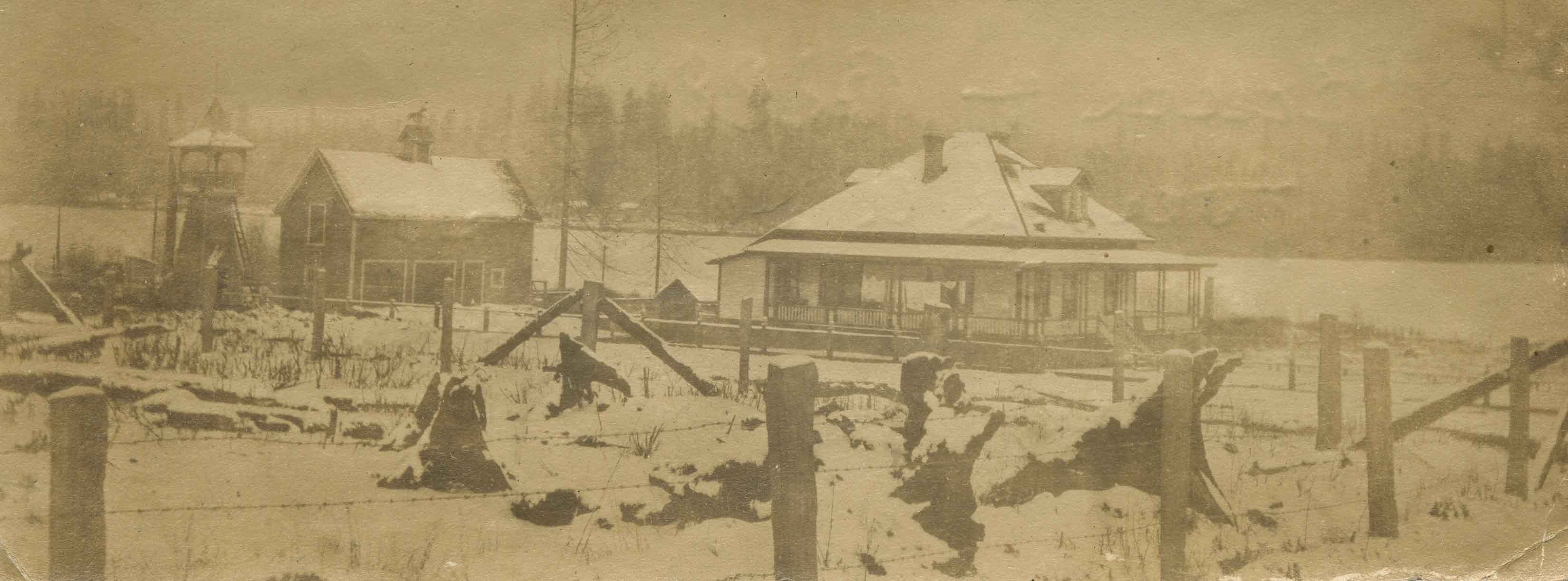
- Photograph of Rowe Ranch, on Burnaby Lake, at the foot of Burris Street. The lake is covered in snow and ice.
- Repository
- City of Burnaby Archives
- Date
- 1911
- Collection/Fonds
- Burnaby Historical Society fonds
- Subseries
- Patterson family subseries
- Physical Description
- 1 photograph : sepia ; 5 x 14 cm
- Description Level
- Item
- Record No.
- 213-004
- Access Restriction
- No restrictions
- Reproduction Restriction
- No known restrictions
- Accession Number
- BHS1988-13
- Scope and Content
- Photograph of Rowe Ranch, on Burnaby Lake, at the foot of Burris Street. The lake is covered in snow and ice.
- Subjects
- Geographic Features - Lakes and Ponds
- Natural Phenomena - Snow
- Buildings - Residential - Houses
- Media Type
- Photograph
- Notes
- Title based on contents of photograph
- Handwritten note on verso of photograph reads: "Bruce and Bill found a deer frozen in Burnaby lake in the ice".
- Geographic Access
- Burnaby Lake
- Burris Street
- Historic Neighbourhood
- Burnaby Lake (Historic Neighbourhood)
- Planning Study Area
- Burnaby Lake Area
Images
![Rowing on Burnaby Lake, [1972] thumbnail](/media/hpo/_Data/_Archives_Images/_Unrestricted/371/389-007.jpg?width=280)
Rowing on Burnaby Lake
https://search.heritageburnaby.ca/link/archivedescription39794
- Repository
- City of Burnaby Archives
- Date
- [1972]
- Collection/Fonds
- Burnaby Historical Society fonds
- Description Level
- Item
- Physical Description
- 1 photograph : b&w ; 8.7 x 13.3 cm
- Scope and Content
- Photograph of a man rowing on Burnaby Lake.
- Repository
- City of Burnaby Archives
- Date
- [1972]
- Collection/Fonds
- Burnaby Historical Society fonds
- Subseries
- Photographs subseries
- Physical Description
- 1 photograph : b&w ; 8.7 x 13.3 cm
- Description Level
- Item
- Record No.
- 389-007
- Access Restriction
- No restrictions
- Reproduction Restriction
- Reproduce for fair dealing purposes only
- Accession Number
- BHS2007-04
- Scope and Content
- Photograph of a man rowing on Burnaby Lake.
- Media Type
- Photograph
- Notes
- Title based on contents of photograph.
- Geographic Access
- Burnaby Lake
- Roberts Street
- Street Address
- 6871 Roberts Street
- Historic Neighbourhood
- Burnaby Lake (Historic Neighbourhood)
- Planning Study Area
- Burnaby Lake Area
Images
![Rowing on Burnaby Lake, [1972] thumbnail](/media/hpo/_Data/_Archives_Images/_Unrestricted/371/389-007.jpg)
![Rowing on Burnaby Lake, [1972] thumbnail](/media/hpo/_Data/_Archives_Images/_Unrestricted/371/389-008.jpg?width=280)
Rowing on Burnaby Lake
https://search.heritageburnaby.ca/link/archivedescription39795
- Repository
- City of Burnaby Archives
- Date
- [1972]
- Collection/Fonds
- Burnaby Historical Society fonds
- Description Level
- Item
- Physical Description
- 1 photograph : b&w ; 8.7 x 13.3 cm
- Scope and Content
- Photograph of a man rowing on Burnaby Lake, while three others can be seen in the foreground getting into a boat.
- Repository
- City of Burnaby Archives
- Date
- [1972]
- Collection/Fonds
- Burnaby Historical Society fonds
- Subseries
- Photographs subseries
- Physical Description
- 1 photograph : b&w ; 8.7 x 13.3 cm
- Description Level
- Item
- Record No.
- 389-008
- Access Restriction
- No restrictions
- Reproduction Restriction
- Reproduce for fair dealing purposes only
- Accession Number
- BHS2007-04
- Scope and Content
- Photograph of a man rowing on Burnaby Lake, while three others can be seen in the foreground getting into a boat.
- Media Type
- Photograph
- Notes
- Title based on contents of photograph.
- Geographic Access
- Burnaby Lake
- Roberts Street
- Street Address
- 6871 Roberts Street
- Historic Neighbourhood
- Burnaby Lake (Historic Neighbourhood)
- Planning Study Area
- Burnaby Lake Area
Images
![Rowing on Burnaby Lake, [1972] thumbnail](/media/hpo/_Data/_Archives_Images/_Unrestricted/371/389-008.jpg)
Skating on Burnaby Lake
https://search.heritageburnaby.ca/link/archivedescription45970
- Repository
- City of Burnaby Archives
- Date
- January 4, 1974
- Collection/Fonds
- Columbian Newspaper collection
- Description Level
- Item
- Physical Description
- 1 photograph : b&w ; 15 x 19.5 cm
- Scope and Content
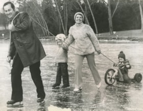
- Photograph of the Miles family enjoying the ice on Burnaby Lake. Ian Miles is skating in front with a rope over his shoulder, that is tied to a tricycle being ridden by two year old Emil who is at the back of the group. Martha Miles is skating behind her husband, holding on to their other son Jason…
- Repository
- City of Burnaby Archives
- Date
- January 4, 1974
- Collection/Fonds
- Columbian Newspaper collection
- Physical Description
- 1 photograph : b&w ; 15 x 19.5 cm
- Description Level
- Item
- Record No.
- 480-865
- Access Restriction
- No restrictions
- Reproduction Restriction
- No restrictions
- Accession Number
- 2003-02
- Scope and Content
- Photograph of the Miles family enjoying the ice on Burnaby Lake. Ian Miles is skating in front with a rope over his shoulder, that is tied to a tricycle being ridden by two year old Emil who is at the back of the group. Martha Miles is skating behind her husband, holding on to their other son Jason's hand on one side, and on to the same rope that her husband is holding with her other hand.
- Media Type
- Photograph
- Photographer
- King, Basil
- Notes
- Title based on contents of photograph
- Newspaper clipping attached to verso of photograph reads: "FAMILY FUN ...Taking advantage of the cold weather, Ian and Martha Miles of Burnaby take children Jason, 4, and Emil, 2, for a spin on Burnaby Lake ice. the frozen lake drew 2,000 skaters on the weekend and hundreds more have been turning out in the evenings to enjoy the ice while it lasts. Skaters are advised to call their local parks and recreation department before skating to find out if the ice is still safe. The cool weather is likely to last until the weekend."
- Geographic Access
- Burnaby Lake
- Historic Neighbourhood
- Burnaby Lake (Historic Neighbourhood)
- Planning Study Area
- Burnaby Lake Area
Images

![Snow Owl / Burnaby Lake Snow Pictures, [between 1970 and 2001] thumbnail](/media/hpo/_Data/_Archives_Images/_Unrestricted/600/618-020-9.jpg?width=280)
Snow Owl / Burnaby Lake Snow Pictures
https://search.heritageburnaby.ca/link/archivedescription91702
- Repository
- City of Burnaby Archives
- Date
- [between 1970 and 2001]
- Collection/Fonds
- Doreen Lawson fonds
- Description Level
- File
- Physical Description
- 25 photographs : col. negatives ; 35 mm
- Scope and Content
- File consists photographs of a snow-covered Burnaby Lake and a snowy owl perched on a large tree stump.
- Repository
- City of Burnaby Archives
- Date
- [between 1970 and 2001]
- Collection/Fonds
- Doreen Lawson fonds
- Physical Description
- 25 photographs : col. negatives ; 35 mm
- Description Level
- File
- Record No.
- 618-020
- Access Restriction
- No restrictions
- Reproduction Restriction
- No restrictions
- Accession Number
- 2015-15
- Scope and Content
- File consists photographs of a snow-covered Burnaby Lake and a snowy owl perched on a large tree stump.
- Subjects
- Geographic Features - Lakes and Ponds
- Animals - Birds
- Plants - Trees
- Natural Phenomena - Snow
- Media Type
- Photograph
- Photographer
- Lawson, Doreen A.
- Notes
- Transcribed title
- Title transcribed from negative envelope
- Geographic Access
- Burnaby Lake
- Historic Neighbourhood
- Burnaby Lake (Historic Neighbourhood)
- Planning Study Area
- Burnaby Lake Area
Images
![Snow Owl / Burnaby Lake Snow Pictures, [between 1970 and 2001] thumbnail](/media/hpo/_Data/_Archives_Images/_Unrestricted/600/618-020-9.jpg)

Stormont Overpass
https://search.heritageburnaby.ca/link/archivedescription45376
- Repository
- City of Burnaby Archives
- Date
- August 1978
- Collection/Fonds
- Columbian Newspaper collection
- Description Level
- Item
- Physical Description
- 1 photograph : b&w ; 12.5 x 24 cm
- Scope and Content
- Aerial photograph of Stormont Overpass which would provide a direct link from the Trans Canada Highway (previously named the 401 Freeway) to the Lougheed Highway and Simon Fraser University. This was taken when the excavation work was completed, and grading and paving still need to be done.
- Repository
- City of Burnaby Archives
- Date
- August 1978
- Collection/Fonds
- Columbian Newspaper collection
- Physical Description
- 1 photograph : b&w ; 12.5 x 24 cm
- Description Level
- Item
- Record No.
- 480-271
- Access Restriction
- No restrictions
- Reproduction Restriction
- No restrictions
- Accession Number
- 2003-02
- Scope and Content
- Aerial photograph of Stormont Overpass which would provide a direct link from the Trans Canada Highway (previously named the 401 Freeway) to the Lougheed Highway and Simon Fraser University. This was taken when the excavation work was completed, and grading and paving still need to be done.
- Media Type
- Photograph
- Photographer
- Hodge, Craig
- Notes
- Title based on contents of photograph
- Note in pencil on verso of photograph reads: "Altair Aviation / photo by / Craig Hodge"
- Geographic Access
- Cariboo Road
- Gaglardi Way
- Trans Canada Highway
- Historic Neighbourhood
- Burquitlam (Historic Neighbourhood)
- Planning Study Area
- Burnaby Lake Area
- Cameron Area
Images


Stormont Overpass
https://search.heritageburnaby.ca/link/archivedescription45377
- Repository
- City of Burnaby Archives
- Date
- August 1978
- Collection/Fonds
- Columbian Newspaper collection
- Description Level
- Item
- Physical Description
- 1 photograph : b&w ; 16.5 x 24 cm
- Scope and Content
- Aerial photograph of Stormont Overpass which would provide a direct link from the 401 Freeway to the Lougheed Highway and Simon Fraser University. This was taken when the excavation work was completed, and grading and paving still need to be done.
- Repository
- City of Burnaby Archives
- Date
- August 1978
- Collection/Fonds
- Columbian Newspaper collection
- Physical Description
- 1 photograph : b&w ; 16.5 x 24 cm
- Description Level
- Item
- Record No.
- 480-272
- Access Restriction
- No restrictions
- Reproduction Restriction
- No restrictions
- Accession Number
- 2003-02
- Scope and Content
- Aerial photograph of Stormont Overpass which would provide a direct link from the 401 Freeway to the Lougheed Highway and Simon Fraser University. This was taken when the excavation work was completed, and grading and paving still need to be done.
- Media Type
- Photograph
- Photographer
- Hodge, Craig
- Notes
- Title based on contents of photograph
- Newspaper clipping attached to verso of photograph reads: "After six years, work on the Stormont interchange in Burnaby is only a few weeks from completion. The huge clover-leaf junction of Gaglardi Way and the Freeway is on the top left-hand corner, with Gaglardi Way approaching from the bottom right where a bridge has been completed over the Burlington Northern tracks. An embankment linking that bridge with one over the Brunette River awaits only a layer of tarmac, and a path has been cleared through the woods to link up with the clover-leaf. The present access to the Freeway is along the road running from the left to right across the middle of the picture. The interchange will open next month."
- Note in pencil on verso of photograph reads: "Altair Aviation / photo by / Craig Hodge"
- Geographic Access
- Cariboo Road
- Gaglardi Way
- Trans Canada Highway
- Historic Neighbourhood
- Burquitlam (Historic Neighbourhood)
- Planning Study Area
- Burnaby Lake Area
- Cameron Area
Images

![Stormont Overpass, [1978] thumbnail](/media/hpo/_Data/_Archives_Images/_Unrestricted/480/480-275.jpg?width=280)
Stormont Overpass
https://search.heritageburnaby.ca/link/archivedescription45380
- Repository
- City of Burnaby Archives
- Date
- [1978]
- Collection/Fonds
- Columbian Newspaper collection
- Description Level
- Item
- Physical Description
- 1 photograph : b&w ; 16 x 24 cm
- Scope and Content
- Aerial photograph of Stormont Overpass which would provide a direct link from the Trans Canada Highway (previously named the 401 Freeway) to the Lougheed Highway and Simon Fraser University. This was taken when the excavation work was completed, and paving still need to be done.
- Repository
- City of Burnaby Archives
- Date
- [1978]
- Collection/Fonds
- Columbian Newspaper collection
- Physical Description
- 1 photograph : b&w ; 16 x 24 cm
- Description Level
- Item
- Record No.
- 480-275
- Access Restriction
- No restrictions
- Reproduction Restriction
- No restrictions
- Accession Number
- 2003-02
- Scope and Content
- Aerial photograph of Stormont Overpass which would provide a direct link from the Trans Canada Highway (previously named the 401 Freeway) to the Lougheed Highway and Simon Fraser University. This was taken when the excavation work was completed, and paving still need to be done.
- Media Type
- Photograph
- Photographer
- King, Basil
- Notes
- Title based on contents of photograph
- Note on verso of photograph reads: "One of the biggest Highways"
- Geographic Access
- Cariboo Road
- Gaglardi Way
- Trans Canada Highway
- Historic Neighbourhood
- Burquitlam (Historic Neighbourhood)
- Planning Study Area
- Burnaby Lake Area
- Cameron Area
Images
![Stormont Overpass, [1978] thumbnail](/media/hpo/_Data/_Archives_Images/_Unrestricted/480/480-275.jpg)
![Survey and Subdivision plans in New Westminster District Group 1 – Burnaby, Port Moody, [1862-1908] thumbnail](/media/hpo/_Data/_BVM_Cartographic_Material/1977/1977_0093_0026a_001.jpg?width=280)
Survey and Subdivision plans in New Westminster District Group 1 – Burnaby, Port Moody
https://search.heritageburnaby.ca/link/museumdescription6995
- Repository
- Burnaby Village Museum
- Date
- [1862-1908]
- Collection/Fonds
- Burnaby Village Museum Map collection
- Description Level
- File
- Physical Description
- 9 plans : 6 plans : black ink on paper ; 57 x 36.5 cm or smaller + 1 plan : black ink and grahite on paper ; 46.5 x 49 cm + 1 plan : blueprint on paper ; 15.5 x 19.5 cm + cm + 1 plan : graphite on paper ; 25 x 17 cm ; mounted on both sides of board 76 x 102 cm
- Scope and Content
- Item consists of a large board of four New Westminster District subdivision plans mounted on one side and five New Westminster District subdivision plans mounted on the other side. Side A: 1. "Plan / of Subdivision / of a Portion / of / Lot 87 / Group One / New Westminster District / Scale 4 chs…
- Repository
- Burnaby Village Museum
- Collection/Fonds
- Burnaby Village Museum Map collection
- Description Level
- File
- Physical Description
- 9 plans : 6 plans : black ink on paper ; 57 x 36.5 cm or smaller + 1 plan : black ink and grahite on paper ; 46.5 x 49 cm + 1 plan : blueprint on paper ; 15.5 x 19.5 cm + cm + 1 plan : graphite on paper ; 25 x 17 cm ; mounted on both sides of board 76 x 102 cm
- Material Details
- Scales [between 1:792 and 1:3600]
- Index number on edge of board reads: "26"
- Scope and Content
- Item consists of a large board of four New Westminster District subdivision plans mounted on one side and five New Westminster District subdivision plans mounted on the other side. Side A: 1. "Plan / of Subdivision / of a Portion / of / Lot 87 / Group One / New Westminster District / Scale 4 chs = 1 in". Plan is stamped: "Albert J. Hill, Civil Engineer / and / Provincial Land Surveyor, / New Westminster, / B.C." and intialed by: "RB" [sic] (in blue pencil crayon). Names two of the subdivisons of District Lot 87 are identified as, "L.E. Sprott" and "John Ledger". (Geographic location: Burnaby) 2. "Plan of Subdivision / of / Portions of / Lot 136, 131 and Lots 44 and 78 Gr.1 / New Westminster District / Scale 300 ft = 1 inch". Annotation above title reads: "No. 901 / Deposited in Land Registry Office / New Westminster / Aug. 19th 1905 / Charles S. Keith D. Reg." Annotations and signatures at bottom of plan read: "I, William Nelson Draper, / W.H.R. Collister / Charles E. Perkins / E.B. Morgan / make / Surveys / correct / representation / upon / the / Land Registry Act / (sgd) W.N. Draper, P.L.S.". Plan includes a handwritten title: "Lots 136, 131, 44 & 78" and is initialed: "RB" [sic] (in blue pencil crayon) (Geographic location: Burnaby) 3. "Survey / of / a Portion / of / Lot 95, Gr.1 / Scale 1 ch = 1in." Plan is stamped: "Albert J. Hill, Civil Engineer / and / Provincial Land Surveyor, / New Westminster, / B.C." and is initialed : "RB" [sic] (in blue pencil crayon) (Geographic location: Burnaby) 4. Blueprint plan of "Lot 396. Group One." with Scale : 3 chs = 1 in. A two acre portion of District Lot 396 is filled in with red ink." Plan is signed by "Albert J. Hill / B.C.L.S." (Geographic location: Port Moody) Side B: 1. Plan titled "District Lot 92 / Burnaby / Municipality / for sale by / Mahon / McFarland & / Mahon Ltd. / Vancouver, B.C. / Scale : 4 chains to one inch". District Lot 92 is subdivided into 161 lots and identifies roads: Norwich Road, Pole Line Road, Oakland Road, Stanley Road, Burford Road, Dalhousie Road, Brantford Road, Colborne Road, Roberts Road, Vancouver & Westminster Road, B.C. Electric Railway, Gilley Stn. and Burnaby (Power House). The bottom of the plan reads: "G.S. Dawson, P.LS. Vancouver, B.C." (Geographic location: Burnaby) 2. "Plan / of Subdivision / of a Portion / of / Lot 29 / Group 1 / New Westminster District / Scale 2 chs = 1 in". Plan is stamped: "Albert J. Hill, Civil Engineer / and / Provincial Land Surveyor, / New Westminster, / B.C." and is initialed by: "RB" [sic] (in blue pencil crayon) (Geographic location: Burnaby) 3. Small handrawn plan (no title) identifying "Lot 84 / Hydes, Claim" at the centre surrounded by lots and features identified as: "Lot 85", "Lot 93", "Lot 94", "Lot 32", "Lot 82", "Lot 83", "Lot 79", "swamp" and a "Small Lake" (Burnaby Lake). Identifying marks in the right corner of the plan read: "Page 13 / Surveyed by G. Turner / May 62". Plan also includes surveyor's bearing measurements and trails to "Small Lake" (Burnaby Lake). (Geographic location: Burnaby) 4. Untitled plan showing District Lots west of North Road and north of Burnaby Lake including: Lots 2, 4, 6, 8, 15, 10, 56, 148, 57, 58, 40. and Lots 3, 5, 7 east of North Road (Coquitlam). Lots in Burnaby are identifed for timber including: "Heavily Timbered" (Lot 57), " "Some Fir and Cedar" (Lot 40), "Splendid Fir and Cedar" (Lot 143), "Heavy Fir etc" (Lots 143 and 148), " "Fine Cedar" (Lot 15), "Rough Light Timber" (Lot 56). Other features identified at the lower portion of the plan include "Burnaby Lake" and "Brunette River". (Geographic location: Burnaby) 5. Untitled plan drawn in graphite showing sections of District Lot 85 south of Burnaby Lake and north of Hazsard Road. Plan is signed: "Albert J. Hill / B.C.L.S." and dated "12/26/08". Plan is initialed by: "RB" [sic] (in blue pencil crayon) (Geographic location: Burnaby)
- Publisher
- Mahon, McFarland & Mahon Ltd
- Accession Code
- HV977.93.26
- Access Restriction
- No restrictions
- Reproduction Restriction
- No known restrictions
- Date
- [1862-1908]
- Media Type
- Cartographic Material
- Historic Neighbourhood
- Burnaby Lake (Historic Neighbourhood)
- Burquitlam (Historic Neighbourhood)
- Planning Study Area
- Burnaby Lake Area
- Scan Resolution
- 300
- Scale
- 72
- Notes
- Title based on contents of file
- Scale is measured in chains and feet. (One chain equals 792 inches)
- The term "Lot" can also refer to a "District Lot”
Images
![Survey and Subdivision plans in New Westminster District Group 1 – Burnaby, Port Moody, [1862-1908] thumbnail](/media/hpo/_Data/_BVM_Cartographic_Material/1977/1977_0093_0026a_001.jpg)

