Narrow Results By
Decade
- 2020s 11
- 2010s
- 2000s 106
- 1990s 88
- 1980s 22
- 1970s 305
- 1960s 73
- 1950s 82
- 1940s
- 1930s 53
- 1920s 88
- 1910s 65
- 1900s
- 1890s 10
- 1880s 2
- 1870s 1
- 1860s
- 1850s 1
- 1840s 1
- 1830s 1
- 1820s 1
- 1810s 1
- 1800s 1
- 1790s 1
- 1780s 1
- 1770s 1
- 1760s 1
- 1750s 1
- 1740s 1
- 1730s 1
- 1720s 1
- 1710s 1
- 1700s 1
- 1690s 1
- 1680s 1
- 1670s 1
- 1660s 1
- 1650s 1
- 1640s 1
- 1630s 1
- 1620s 1
- 1610s 1
- 1600s 1
Subject
- Agricultural Tools and Equipment 3
- Agriculture - Crops 3
- Agriculture - Farms 18
- Agriculture - Fruit and Berries 1
- Animals - Dogs 2
- Animals - Horses 1
- Building Components 1
- Buildings - Agricultural 3
- Buildings - Agricultural - Greenhouses 2
- Buildings - Commercial - Grocery Stores 1
- Buildings - Heritage 6
- Buildings - Industrial - Factories 1

Douglas Road
https://search.heritageburnaby.ca/link/landmark714
- Repository
- Burnaby Heritage Planning
- Associated Dates
- 1865
- Heritage Value
- Douglas Road was built between 1862-1865 by the Royal Engineers based in New Westminster. Originally known as the Douglas Street Trail, it took its name from Governor James Douglas. In 1926 a new connection was made to reach Grandview Road in Vancouver at Boundary Road. To distinguish this new highway it was renamed the Grandview Highway and it became commonly known as the combined Grandview-Douglas Highway until 1968 when the Burnaby and New Westminister sections were renamed Canada Way, in recognition of Canada's Centennial in 1967. The old part of Douglas Road north of Sprott Street remained intact.
- Historic Neighbourhood
- Burnaby Lake (Historic Neighbourhood)
- Planning Study Area
- Douglas-Gilpin Area
- Street View URL
- Google Maps Street View
Images


Douglas Road School
https://search.heritageburnaby.ca/link/landmark754
- Repository
- Burnaby Heritage Planning
- Geographic Access
- Canada Way
- Associated Dates
- 1908
- Heritage Value
- This school was the fifth to open in Burnaby and was initially known as Lake View School. In 1913, names of Burnaby Schools were changed to reflect their location and thus Lake View became Douglas Road. The first building on the site was torn down in the 1950s but the main building, which was constructed in 1928, remains although it had additions and renovations done in 1950, 1954, 1960, 1961, 1967 and 1973.
- Historic Neighbourhood
- Burnaby Lake (Historic Neighbourhood)
- Planning Study Area
- Douglas-Gilpin Area
- Street Address
- 4861 Canada Way
- Street View URL
- Google Maps Street View
Images


H.T. Ceperley Estate 'Fairacres' Greenhouse Foundation Wall
https://search.heritageburnaby.ca/link/landmark862
- Repository
- Burnaby Heritage Planning
- Description
- The original rubble stone walls that formed the foundation for a greenhouses adjacent to the Steam Plant Building provided heat to several greenhouses on the estate propoerty. The Root House, which is to the north of the Greenhouse Foundation Wall, provided storage for the farm operation.
- Associated Dates
- 1908
- Formal Recognition
- Heritage Designation, Community Heritage Register
- Repository
- Burnaby Heritage Planning
- Geographic Access
- Deer Lake Avenue
- Associated Dates
- 1908
- Formal Recognition
- Heritage Designation, Community Heritage Register
- Enactment Type
- Bylaw No. 140665
- Enactment Date
- 23/11/1992
- Description
- The original rubble stone walls that formed the foundation for a greenhouses adjacent to the Steam Plant Building provided heat to several greenhouses on the estate propoerty. The Root House, which is to the north of the Greenhouse Foundation Wall, provided storage for the farm operation.
- Heritage Value
- The outbuildings at 'Fairacres' are a rare surviving architecturally-designed ensemble of agricultural structures that exist in complementary harmony with the main estate house. Architect Robert Mackay Fripp (1858-1917), an outspoken advocate of Arts and Crafts design, was retained by the Ceperleys to design several original outbuildings on their estate, which was designed as a country estate with a working farm that included over 10 acres of productive berry and vegetable fields, with a large kitchen garden, a root house to store food, an orchard, and greenhouses heated by steam. The agricultural potential of the Deer Lake area made it one of the first parts of the municipality to attract settlement. In 1909, the Ceperleys built three large greenhouses heated by an adjacent steam plant (Fairacres Steam Plant). The greenhouses featured granite foundation walls, including this one which remains intact. The Ceperleys employed a large staff to manage the estate's agricultural production, including Chinese farm labourers. Produce was grown for use at the estate, and for sale at local markets. Agricultural use of the estate continued when a Catholic order of Benedictine monks purchased the estate as part of the Priory of St. Joseph and the Seminary of Christ the King, and continued to farm the land until 1953.
- Defining Elements
- Key elements that define the heritage character of the ‘Fairacres’ Steam Plant Building include its: - overall spatial arrangement of the Greenhouse Foundation Wall in relation to the Steam Plant Building and the Root House - original rubble stone walls reflecting the Arts and Crafts design aesthetic of the estate buildings.
- Locality
- Deer Lake Park
- Historic Neighbourhood
- Burnaby Lake (Historic Neighbourhood)
- Planning Study Area
- Douglas-Gilpin Area
- Architect
- Robert Mackay Fripp
- Function
- Primary Historic--Outbuilding
- Community
- Burnaby
- Cadastral Identifier
- P.I.D. No. 004-493-311 Legal Description: Block 3 Except: Part subdivided by Plan 26865, District Lot 79, Group 1, New Westminster District, Plan 536
- Boundaries
- ‘Fairacres’ is comprised of a single municipally-owned property located at 6344 Deer Lake Avenue, Burnaby.
- Area
- 17,065.00
- Contributing Resource
- Landscape Feature
- Remains
- Ownership
- Public (local)
- Other Collection
- Burnaby Historical Society, Community Archives: Ceperley Photograph Album
- Documentation
- Heritage Site Files: PC77000 20. City of Burnaby Planning and Building Department, 4949 Canada Way, Burnaby, B.C., V5G 1M2
- Street Address
- 6344 Deer Lake Avenue
Images


H.T. Ceperley Estate 'Fairacres' Root House
https://search.heritageburnaby.ca/link/landmark527
- Repository
- Burnaby Heritage Planning
- Description
- The ‘Fairacres’ Root House is a long, low one-storey masonry building, measuring 4.6 metres by 9.1 metres, with massively buttressed concrete walls and foundations. Built into sloping ground adjacent to the location of the former greenhouses, the surviving orchard and the kitchen entrance of the ma…
- Associated Dates
- 1908
- Formal Recognition
- Heritage Designation, Community Heritage Register
- Repository
- Burnaby Heritage Planning
- Geographic Access
- Deer Lake Avenue
- Associated Dates
- 1908
- Formal Recognition
- Heritage Designation, Community Heritage Register
- Enactment Type
- Bylaw No. 9807
- Enactment Date
- 23/11/1992
- Description
- The ‘Fairacres’ Root House is a long, low one-storey masonry building, measuring 4.6 metres by 9.1 metres, with massively buttressed concrete walls and foundations. Built into sloping ground adjacent to the location of the former greenhouses, the surviving orchard and the kitchen entrance of the main house, 'Fairacres,' this functional structure was used as a frost-free store for fruit and vegetables for the family's use.
- Heritage Value
- The outbuildings at 'Fairacres' are a rare surviving architecturally-designed ensemble of agricultural structures that exist in complementary harmony with the main estate house. Architect Robert Mackay Fripp (1858-1917), an outspoken advocate of Arts and Crafts design, was retained by the Ceperleys to design several original outbuildings on their estate. The Root House is important as a rare surviving, and exceptionally large, example of this building type in the Vancouver region. Unusual in the fact that an architect designed a building of such modest aspirations, it is also remarkable in its method of construction. The use of concrete as a structural material is one of the earliest in the region and extraordinary for its use on such a modest vernacular outbuilding; root cellars were typically built of loose stone. Built in 1908, the Root House was significantly altered in the 1960s and restored to its original design in 2000. The building is significant as an indicator of the market gardening activity in the area around Deer Lake and of the country-house self-sufficiency practiced by the Ceperley family. The Root House illustrates the cultural, aesthetic, and lifestyle values of the Ceperleys in constructing such a large building for storing their own produce.
- Defining Elements
- The outbuildings at 'Fairacres' are a rare surviving architecturally-designed ensemble of agricultural structures that exist in complementary harmony with the main estate house. Architect Robert Mackay Fripp (1858-1917), an outspoken advocate of Arts and Crafts design, was retained by the Ceperleys to design several original outbuildings on their estate. The Root House is important as a rare surviving, and exceptionally large, example of this building type in the Vancouver region. Unusual in the fact that an architect designed a building of such modest aspirations, it is also remarkable in its method of construction. The use of concrete as a structural material is one of the earliest in the region and extraordinary for its use on such a modest vernacular outbuilding; root cellars were typically built of loose stone. Built in 1908, the Root House was significantly altered in the 1960s and restored to its original design in 2000. The building is significant as an indicator of the market gardening activity in the area around Deer Lake and of the country-house self-sufficiency practiced by the Ceperley family. The Root House illustrates the cultural, aesthetic, and lifestyle values of the Ceperleys in constructing such a large building for storing their own produce.
- Locality
- Deer Lake Park
- Historic Neighbourhood
- Burnaby Lake (Historic Neighbourhood)
- Planning Study Area
- Douglas-Gilpin Area
- Architect
- Robert Mackay Fripp
- Function
- Primary Historic--Outbuilding
- Secondary Historic--Food Storage
- Community
- Burnaby
- Cadastral Identifier
- P.I.D. No. 004-493-311 Legal Description: Block 3 Except: Part subdivided by Plan 26865, District Lot 79, Group 1, New Westminster District, Plan 536
- Boundaries
- ‘Fairacres’ is comprised of a single municipally-owned property located at 6344 Deer Lake Avenue, Burnaby.
- Area
- 17,065.00
- Contributing Resource
- Building
- Landscape Feature
- Ownership
- Public (local)
- Other Collection
- Burnaby Historical Society, Community Archives: Ceperley Photograph Album
- Documentation
- Heritage Site Files: PC77000 20. City of Burnaby Planning and Building Department, 4949 Canada Way, Burnaby, B.C., V5G 1M2
- Street Address
- 6344 Deer Lake Avenue
Images


H.T. Ceperley Estate 'Fairacres' Steam Plant Building
https://search.heritageburnaby.ca/link/landmark528
- Repository
- Burnaby Heritage Planning
- Description
- Designed in the British Arts and Crafts style, the ‘Fairacres’ Steam Plant Buiding is a single-storey wood frame building with a gabled roof that originally housed the apparatus for climate control in the greenhouses, formerly located to its north. The original rubble stone walls that formed the fo…
- Associated Dates
- 1908
- Formal Recognition
- Heritage Designation, Community Heritage Register
- Repository
- Burnaby Heritage Planning
- Geographic Access
- Deer Lake Avenue
- Associated Dates
- 1908
- Formal Recognition
- Heritage Designation, Community Heritage Register
- Enactment Type
- Bylaw No. 9807
- Enactment Date
- 23/11/1992
- Description
- Designed in the British Arts and Crafts style, the ‘Fairacres’ Steam Plant Buiding is a single-storey wood frame building with a gabled roof that originally housed the apparatus for climate control in the greenhouses, formerly located to its north. The original rubble stone walls that formed the foundation for the greenhouses stand adjacent. The Steam Plant Building stands as a pendant to the Root House, which is to the north of the former greenhouses.
- Heritage Value
- The outbuildings at 'Fairacres' are a rare surviving architecturally-designed ensemble of agricultural structures that exist in complementary harmony with the main estate house. Architect Robert Mackay Fripp (1858-1917), an outspoken advocate of Arts and Crafts design, was retained by the Ceperleys to design several original outbuildings on their estate. The Ceperleys operated 'Fairacres' with staff, a farm manager and workers, including Chinese, to grow produce for themselves and for sale at local markets. The Steam Plant Building illustrates the market gardening activity of the area around Deer Lake and its importance to the Ceperley family, which valued a year-round supply of fresh fruit and vegetables for the kitchen and flowers for the house. It also illustrates the cultural and aesthetic values of the Ceperleys in retaining an architect to design a functional outbuilding using an accepted and contemporary architectural style. Built in 1908, the Steam Plant Building was significantly altered in the 1960s and restored to its original design in 2000.
- Defining Elements
- Key elements that define the heritage character of the ‘Fairacres’ Steam Plant Building include its: - overall spatial arrangement of the Steam Plant Building in relation to the former greenhouses and the Root House - side gable roof with cedar shingle cladding. - tall brick chimney indicitive of the building's original function. - distinctive Arts and Crafts architectural features such as the shingle wall cladding with decorative shingling under window sills, deep eaves, and pebble-dashed concrete foundation walls - six-paned wooden-sash casement windows - simple functional interior features - rubble stone walls that formed the foundation for the greenhouses
- Locality
- Deer Lake Park
- Historic Neighbourhood
- Burnaby Lake (Historic Neighbourhood)
- Planning Study Area
- Douglas-Gilpin Area
- Architect
- Robert Mackay Fripp
- Function
- Primary Historic--Outbuilding
- Community
- Burnaby
- Cadastral Identifier
- P.I.D. No. 004-493-311 Legal Description: Block 3 Except: Part subdivided by Plan 26865, District Lot 79, Group 1, New Westminster District, Plan 536
- Boundaries
- ‘Fairacres’ is comprised of a single municipally-owned property located at 6344 Deer Lake Avenue, Burnaby.
- Area
- 17,065.00
- Contributing Resource
- Building
- Landscape Feature
- Ownership
- Public (local)
- Other Collection
- Burnaby Historical Society, Community Archives: Ceperley Photograph Album
- Documentation
- Heritage Site Files: PC77000 20. City of Burnaby Planning and Building Department, 4949 Canada Way, Burnaby, B.C., V5G 1M2
- Street Address
- 6344 Deer Lake Avenue
Images


Film of Julie Lee discussing her family farm in the Big Bend area
https://search.heritageburnaby.ca/link/museumdescription4378
- Repository
- Burnaby Village Museum
- Date
- 6 Oct 2017
- Collection/Fonds
- Burnaby Village Museum fonds
- Description Level
- Item
- Physical Description
- 1 m4v video (13 min., 59 sec.) : digital, 23 fps, col., sd., stereo
- Scope and Content
- Film of Julie Lee discussing her family farm in the Big Bend area of Burnaby during a presentation as part of the "Chinese Canadian Stories" Lecture. This lecture was part of the Burnaby Neighbourhood History Series on October 4, 2017 at the Metrotown branch of the Burnaby Public Library. Julie Lee…
- Repository
- Burnaby Village Museum
- Collection/Fonds
- Burnaby Village Museum fonds
- Description Level
- Item
- Physical Description
- 1 m4v video (13 min., 59 sec.) : digital, 23 fps, col., sd., stereo
- Scope and Content
- Film of Julie Lee discussing her family farm in the Big Bend area of Burnaby during a presentation as part of the "Chinese Canadian Stories" Lecture. This lecture was part of the Burnaby Neighbourhood History Series on October 4, 2017 at the Metrotown branch of the Burnaby Public Library. Julie Lee discusses what life was like growing up on her family farm in the Douglas-Gilpin area, at the corner of Still Creek and Douglas Road in Burnaby.
- History
- Julie Lee is the daughter of Suey Ying Jung (Laura) and Puy Yuen Chan. The couple were married at Fraser Mills in October, 1942. The family owned a farm on Douglas Road near Still Creek in the early 1900s. Their farm was located in front of the Douglas Road interurban tram station.
- Subjects
- Agriculture - Farms
- Accession Code
- BV018.6.1
- Reproduction Restriction
- No known restrictions
- Date
- 6 Oct 2017
- Media Type
- Moving Images
- Historic Neighbourhood
- Burnaby Lake (Historic Neighbourhood)
- Planning Study Area
- Douglas-Gilpin Area
- Notes
- Title based on contents of film
Images

Video
Film of Julie Lee discussing her family farm in the Big Bend area, 6 Oct 2017
Film of Julie Lee discussing her family farm in the Big Bend area, 6 Oct 2017
https://search.heritageburnaby.ca/media/hpo/_Data/_BVM_Moving_Images/2018_0006_0001_001.m4v
History of Burnaby Resource Guide
https://search.heritageburnaby.ca/link/museumlibrary7492
- Repository
- Burnaby Village Museum
- Author
- Burnaby Village Museum
- Publication Date
- 2019
Lee, discussing family farm in the Douglas-Gilpin area, at the corner
of Still Creek and Douglas Road in Burnaby.
Available online at HeritageBurnaby.ca
Ken Yip, discussing family farm in the Big Bend area, on Byrne Road in Burnaby.
Available online at HeritageBurnaby.ca
100 Years of Gilmore School
- Repository
- Burnaby Village Museum
- Collection
- Digital Reference Collection
- Material Type
- Digital Resource
- Accession Code
- BV019.63.1
- Author
- Burnaby Village Museum
- Place of Publication
- Burnaby, BC
- Publisher
- City of Burnaby
- Publication Date
- 2019
- Physical Description
- 21 p. : ill.
- Library Subject (LOC)
- Burnaby (B.C.)--History
- Directories
- Object History
- Created from research gathered by Burnaby Village Museum staff into the diverse History of Burnaby.
Images

Digital Books
Anderson family home
https://search.heritageburnaby.ca/link/archivedescription37432
- Repository
- City of Burnaby Archives
- Date
- 1949 (date of original), copied 1991
- Collection/Fonds
- Burnaby Historical Society fonds
- Description Level
- Item
- Physical Description
- 1 photograph : b&w ; 3.2 x 4.2 cm print on contact sheet 20.2 x 25.3 cm
- Scope and Content
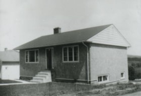
- Photograph of the front of the Anderson family home at 4437 Norland Avenue (later renumbered 3908 Norland Avenue). Robert and Madelaine Anderson lived here with their family.
- Repository
- City of Burnaby Archives
- Date
- 1949 (date of original), copied 1991
- Collection/Fonds
- Burnaby Historical Society fonds
- Subseries
- Burnaby Image Bank subseries
- Physical Description
- 1 photograph : b&w ; 3.2 x 4.2 cm print on contact sheet 20.2 x 25.3 cm
- Description Level
- Item
- Record No.
- 370-020
- Access Restriction
- No restrictions
- Reproduction Restriction
- No restrictions
- Accession Number
- BHS1999-03
- Scope and Content
- Photograph of the front of the Anderson family home at 4437 Norland Avenue (later renumbered 3908 Norland Avenue). Robert and Madelaine Anderson lived here with their family.
- Subjects
- Buildings - Residential - Houses
- Media Type
- Photograph
- Notes
- Title based on contents of photograph
- 1 b&w copy negative accompanying
- Geographic Access
- Norland Avenue
- Street Address
- 3908 Norland Avenue
- Historic Neighbourhood
- Burnaby Lake (Historic Neighbourhood)
- Planning Study Area
- Douglas-Gilpin Area
Images

![Audrey Pontifex, [1941 or 1942] (date of original), copied 1991 thumbnail](/media/hpo/_Data/_Archives_Images/_Unrestricted/370/370-509.jpg?width=280)
Audrey Pontifex
https://search.heritageburnaby.ca/link/archivedescription37921
- Repository
- City of Burnaby Archives
- Date
- [1941 or 1942] (date of original), copied 1991
- Collection/Fonds
- Burnaby Historical Society fonds
- Description Level
- Item
- Physical Description
- 1 photograph : b&w ; 3.9 x 2.6 cm print on contact sheet 20.7 x 26.5 cm
- Scope and Content
- Photograph of Audrey Pontifex at the front of 4006 Douglas Road (old numbering) and Gilpin Street.
- Repository
- City of Burnaby Archives
- Date
- [1941 or 1942] (date of original), copied 1991
- Collection/Fonds
- Burnaby Historical Society fonds
- Subseries
- Burnaby Image Bank subseries
- Physical Description
- 1 photograph : b&w ; 3.9 x 2.6 cm print on contact sheet 20.7 x 26.5 cm
- Description Level
- Item
- Record No.
- 370-509
- Access Restriction
- No restrictions
- Reproduction Restriction
- No known restrictions
- Accession Number
- BHS1999-03
- Scope and Content
- Photograph of Audrey Pontifex at the front of 4006 Douglas Road (old numbering) and Gilpin Street.
- Media Type
- Photograph
- Notes
- Title based on contents of photograph
- 1 b&w copy negative accompanying
- Negative has a pink cast
- Geographic Access
- Gilpin Street
- Historic Neighbourhood
- Burnaby Lake (Historic Neighbourhood)
- Planning Study Area
- Douglas-Gilpin Area
Images
![Audrey Pontifex, [1941 or 1942] (date of original), copied 1991 thumbnail](/media/hpo/_Data/_Archives_Images/_Unrestricted/370/370-509.jpg)
![Barbara Martin, [between 1933 and 1940] (date of original), copied 2011 thumbnail](/media/hpo/_Data/_Archives_Images/_Unrestricted/513/525-001.jpg?width=280)
Barbara Martin
https://search.heritageburnaby.ca/link/archivedescription66695
- Repository
- City of Burnaby Archives
- Date
- [between 1933 and 1940] (date of original), copied 2011
- Collection/Fonds
- William Martin family fonds
- Description Level
- Item
- Physical Description
- 1 photograph (jpeg)
- Scope and Content
- Photograph of Barbara Martin (later Punnett) standing outside, at the side of the family's Spruce Street home at 3240 Spruce Street (renumbered 5420 Spruce Street).
- Repository
- City of Burnaby Archives
- Date
- [between 1933 and 1940] (date of original), copied 2011
- Collection/Fonds
- William Martin family fonds
- Physical Description
- 1 photograph (jpeg)
- Description Level
- Item
- Record No.
- 525-001
- Access Restriction
- No restrictions
- Reproduction Restriction
- No restrictions
- Accession Number
- 2011-11
- Scope and Content
- Photograph of Barbara Martin (later Punnett) standing outside, at the side of the family's Spruce Street home at 3240 Spruce Street (renumbered 5420 Spruce Street).
- Names
- Punnett, Barbara Martin
- Media Type
- Photograph
- Photographer
- Martin, William
- Notes
- Title based on contents of photograph
- Geographic Access
- Spruce Street
- Historic Neighbourhood
- Burnaby Lake (Historic Neighbourhood)
- Planning Study Area
- Douglas-Gilpin Area
Images
![Barbara Martin, [between 1933 and 1940] (date of original), copied 2011 thumbnail](/media/hpo/_Data/_Archives_Images/_Unrestricted/513/525-001.jpg)
![Barbara Martin, [between 1933 and 1940] (date of original), copied 2011 thumbnail](/media/hpo/_Data/_Archives_Images/_Unrestricted/513/525-002.jpg?width=280)
Barbara Martin
https://search.heritageburnaby.ca/link/archivedescription66696
- Repository
- City of Burnaby Archives
- Date
- [between 1933 and 1940] (date of original), copied 2011
- Collection/Fonds
- William Martin family fonds
- Description Level
- Item
- Physical Description
- 1 photograph (jpeg)
- Scope and Content
- Photograph of Barbara Martin (later Punnett) standing outside on her family's property.
- Repository
- City of Burnaby Archives
- Date
- [between 1933 and 1940] (date of original), copied 2011
- Collection/Fonds
- William Martin family fonds
- Physical Description
- 1 photograph (jpeg)
- Description Level
- Item
- Record No.
- 525-002
- Access Restriction
- No restrictions
- Reproduction Restriction
- No restrictions
- Accession Number
- 2011-11
- Scope and Content
- Photograph of Barbara Martin (later Punnett) standing outside on her family's property.
- Names
- Punnett, Barbara Martin
- Media Type
- Photograph
- Photographer
- Martin, William
- Notes
- Title based on contents of photograph
- Geographic Access
- Spruce Street
- Historic Neighbourhood
- Burnaby Lake (Historic Neighbourhood)
- Planning Study Area
- Douglas-Gilpin Area
Images
![Barbara Martin, [between 1933 and 1940] (date of original), copied 2011 thumbnail](/media/hpo/_Data/_Archives_Images/_Unrestricted/513/525-002.jpg)
![Basil Pontifex, [1947] (date of original), copied 1991 thumbnail](/media/hpo/_Data/_Archives_Images/_Unrestricted/370/370-499.jpg?width=280)
Basil Pontifex
https://search.heritageburnaby.ca/link/archivedescription37911
- Repository
- City of Burnaby Archives
- Date
- [1947] (date of original), copied 1991
- Collection/Fonds
- Burnaby Historical Society fonds
- Description Level
- Item
- Physical Description
- 1 photograph : b&w ; 4.2 x 2.7 cm print on contact sheet 20.2 x 26.3 cm
- Scope and Content
- Photograph of Basil Pontifex at the back of 3181 Douglas Road (old numbering).
- Repository
- City of Burnaby Archives
- Date
- [1947] (date of original), copied 1991
- Collection/Fonds
- Burnaby Historical Society fonds
- Subseries
- Burnaby Image Bank subseries
- Physical Description
- 1 photograph : b&w ; 4.2 x 2.7 cm print on contact sheet 20.2 x 26.3 cm
- Description Level
- Item
- Record No.
- 370-499
- Access Restriction
- No restrictions
- Reproduction Restriction
- No known restrictions
- Accession Number
- BHS1999-03
- Scope and Content
- Photograph of Basil Pontifex at the back of 3181 Douglas Road (old numbering).
- Names
- Pontifex, Basil
- Media Type
- Photograph
- Notes
- Title based on contents of photograph
- 1 b&w copy negative accompanying
- Negative has a pink cast
- Historic Neighbourhood
- Burnaby Lake (Historic Neighbourhood)
- Planning Study Area
- Douglas-Gilpin Area
Images
![Basil Pontifex, [1947] (date of original), copied 1991 thumbnail](/media/hpo/_Data/_Archives_Images/_Unrestricted/370/370-499.jpg)
![Basil Pontifex, [1947] (date of original), copied 1991 thumbnail](/media/hpo/_Data/_Archives_Images/_Unrestricted/370/370-500.jpg?width=280)
Basil Pontifex
https://search.heritageburnaby.ca/link/archivedescription37912
- Repository
- City of Burnaby Archives
- Date
- [1947] (date of original), copied 1991
- Collection/Fonds
- Burnaby Historical Society fonds
- Description Level
- Item
- Physical Description
- 1 photograph : b&w ; 3.9 x 2.5 cm print on contact sheet 20.2 x 26.3 cm
- Scope and Content
- Photograph of Basil Pontifex at the front of 3181 Douglas Road (old numbering) after a snowfall.
- Repository
- City of Burnaby Archives
- Date
- [1947] (date of original), copied 1991
- Collection/Fonds
- Burnaby Historical Society fonds
- Subseries
- Burnaby Image Bank subseries
- Physical Description
- 1 photograph : b&w ; 3.9 x 2.5 cm print on contact sheet 20.2 x 26.3 cm
- Description Level
- Item
- Record No.
- 370-500
- Access Restriction
- No restrictions
- Reproduction Restriction
- No known restrictions
- Accession Number
- BHS1999-03
- Scope and Content
- Photograph of Basil Pontifex at the front of 3181 Douglas Road (old numbering) after a snowfall.
- Subjects
- Buildings - Residential - Houses
- Names
- Pontifex, Basil
- Media Type
- Photograph
- Notes
- Title based on contents of photograph
- 1 b&w copy negative accompanying
- Negative has a pink cast
- Historic Neighbourhood
- Burnaby Lake (Historic Neighbourhood)
- Planning Study Area
- Douglas-Gilpin Area
Images
![Basil Pontifex, [1947] (date of original), copied 1991 thumbnail](/media/hpo/_Data/_Archives_Images/_Unrestricted/370/370-500.jpg)
Basil Pontifex and Joi Barber-Pontifex
https://search.heritageburnaby.ca/link/archivedescription37910
- Repository
- City of Burnaby Archives
- Date
- 1947 (date of original), copied 1991
- Collection/Fonds
- Burnaby Historical Society fonds
- Description Level
- Item
- Physical Description
- 1 photograph : b&w ; 4.2 x 2.7 cm print on contact sheet 20.2 x 26.3 cm
- Scope and Content
- Photograph of Basil Pontifex and Joi Barber-Pontifex standing at the front of 4006 Douglas Road (old numbering) and Gilpin Street.
- Repository
- City of Burnaby Archives
- Date
- 1947 (date of original), copied 1991
- Collection/Fonds
- Burnaby Historical Society fonds
- Subseries
- Burnaby Image Bank subseries
- Physical Description
- 1 photograph : b&w ; 4.2 x 2.7 cm print on contact sheet 20.2 x 26.3 cm
- Description Level
- Item
- Record No.
- 370-498
- Access Restriction
- No restrictions
- Reproduction Restriction
- No known restrictions
- Accession Number
- BHS1999-03
- Scope and Content
- Photograph of Basil Pontifex and Joi Barber-Pontifex standing at the front of 4006 Douglas Road (old numbering) and Gilpin Street.
- Media Type
- Photograph
- Notes
- Title based on contents of photograph
- 1 b&w copy negative accompanying
- Negative has a pink cast
- Geographic Access
- Gilpin Street
- Historic Neighbourhood
- Burnaby Lake (Historic Neighbourhood)
- Planning Study Area
- Douglas-Gilpin Area
Images
![Basil Pontifex in Uniform, [1947] (date of original), copied 1991 thumbnail](/media/hpo/_Data/_Archives_Images/_Unrestricted/370/370-497.jpg?width=280)
Basil Pontifex in Uniform
https://search.heritageburnaby.ca/link/archivedescription37909
- Repository
- City of Burnaby Archives
- Date
- [1947] (date of original), copied 1991
- Collection/Fonds
- Burnaby Historical Society fonds
- Description Level
- Item
- Physical Description
- 1 photograph : b&w ; 4.2 x 2.7 cm print on contact sheet 20.2 x 26.3 cm
- Scope and Content
- Photograph of Basil Pontifex, in his firefighters uniform, at 4006 Douglas Road (old numbering) and Gilpin Street. He is standing in front of a car.
- Repository
- City of Burnaby Archives
- Date
- [1947] (date of original), copied 1991
- Collection/Fonds
- Burnaby Historical Society fonds
- Subseries
- Burnaby Image Bank subseries
- Physical Description
- 1 photograph : b&w ; 4.2 x 2.7 cm print on contact sheet 20.2 x 26.3 cm
- Description Level
- Item
- Record No.
- 370-497
- Access Restriction
- No restrictions
- Reproduction Restriction
- No known restrictions
- Accession Number
- BHS1999-03
- Scope and Content
- Photograph of Basil Pontifex, in his firefighters uniform, at 4006 Douglas Road (old numbering) and Gilpin Street. He is standing in front of a car.
- Names
- Pontifex, Basil
- Media Type
- Photograph
- Notes
- Title based on contents of photograph
- 1 b&w copy negative accompanying
- Negative has a pink cast
- Geographic Access
- Gilpin Street
- Historic Neighbourhood
- Burnaby Lake (Historic Neighbourhood)
- Planning Study Area
- Douglas-Gilpin Area
Images
![Basil Pontifex in Uniform, [1947] (date of original), copied 1991 thumbnail](/media/hpo/_Data/_Archives_Images/_Unrestricted/370/370-497.jpg)

Basil Pontifex's motorcycle
https://search.heritageburnaby.ca/link/archivedescription37905
- Repository
- City of Burnaby Archives
- Date
- 1947 (date of original), copied 1991
- Collection/Fonds
- Burnaby Historical Society fonds
- Description Level
- Item
- Physical Description
- 1 photograph : b&w ; 2.8 x 4.2 cm print on contact sheet 20.2 x 26.3 cm
- Scope and Content
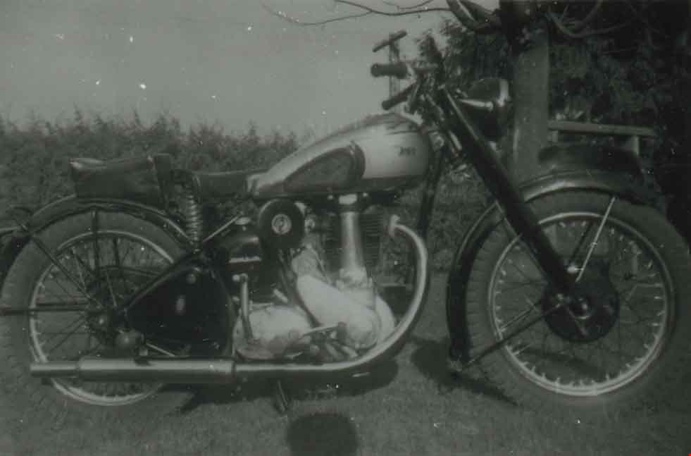
- Photograph of Basil Pontifex's motorcycle at 4006 Douglas Road (old numbering) and Gilpin Street.
- Repository
- City of Burnaby Archives
- Date
- 1947 (date of original), copied 1991
- Collection/Fonds
- Burnaby Historical Society fonds
- Subseries
- Burnaby Image Bank subseries
- Physical Description
- 1 photograph : b&w ; 2.8 x 4.2 cm print on contact sheet 20.2 x 26.3 cm
- Description Level
- Item
- Record No.
- 370-493
- Access Restriction
- No restrictions
- Reproduction Restriction
- No known restrictions
- Accession Number
- BHS1999-03
- Scope and Content
- Photograph of Basil Pontifex's motorcycle at 4006 Douglas Road (old numbering) and Gilpin Street.
- Subjects
- Transportation - Motorcycles
- Media Type
- Photograph
- Notes
- Title based on contents of photograph
- 1 b&w copy negative accompanying
- Negative has a pink cast
- Geographic Access
- Gilpin Street
- Historic Neighbourhood
- Burnaby Lake (Historic Neighbourhood)
- Planning Study Area
- Douglas-Gilpin Area
Images
![Bernard Hill farm, [190-] (date of original), copied 1986 thumbnail](/media/hpo/_Data/_Archives_Images/_Unrestricted/204/204-789.jpg?width=280)
Bernard Hill farm
https://search.heritageburnaby.ca/link/archivedescription35929
- Repository
- City of Burnaby Archives
- Date
- [190-] (date of original), copied 1986
- Collection/Fonds
- Burnaby Historical Society fonds
- Description Level
- Item
- Physical Description
- 1 photograph : b&w ; 12.7 x 17.8 cm print
- Scope and Content
- Photograph of the Hill brothers Frank, Claude and Gerry and their pet dog riding on hay wagon on their father's farm.
- Repository
- City of Burnaby Archives
- Date
- [190-] (date of original), copied 1986
- Collection/Fonds
- Burnaby Historical Society fonds
- Subseries
- Pioneer Tales subseries
- Physical Description
- 1 photograph : b&w ; 12.7 x 17.8 cm print
- Description Level
- Item
- Record No.
- 204-789
- Access Restriction
- No restrictions
- Reproduction Restriction
- No restrictions
- Accession Number
- BHS1988-03
- Scope and Content
- Photograph of the Hill brothers Frank, Claude and Gerry and their pet dog riding on hay wagon on their father's farm.
- Subjects
- Animals - Dogs
- Transportation - Horses
- Agriculture - Crops
- Agricultural Tools and Equipment
- Media Type
- Photograph
- Notes
- Title based on contents of photograph
- Geographic Access
- Douglas Road
- Canada Way
- Street Address
- 4990 Canada Way
- Historic Neighbourhood
- Burnaby Lake (Historic Neighbourhood)
- Planning Study Area
- Douglas-Gilpin Area
Images
![Bernard Hill farm, [190-] (date of original), copied 1986 thumbnail](/media/hpo/_Data/_Archives_Images/_Unrestricted/204/204-789.jpg)
![Bernard Hill's home, [1905] thumbnail](/media/hpo/_Data/_Archives_Images/_Unrestricted/477/477-863.jpg?width=280)
Bernard Hill's home
https://search.heritageburnaby.ca/link/archivedescription39544
- Repository
- City of Burnaby Archives
- Date
- [1905]
- Collection/Fonds
- Peers Family and Hill Family fonds
- Description Level
- Item
- Physical Description
- 1 photograph : b&w ; 7.5 x 10 cm on page 21.5 x 28 cm (pasted in album)
- Scope and Content
- Photograph of the house belonging to Bernard Hill in the Burnaby Lake area on what is now Canada Way. Douglas Road runs through the foreground.
- Repository
- City of Burnaby Archives
- Date
- [1905]
- Collection/Fonds
- Peers Family and Hill Family fonds
- Physical Description
- 1 photograph : b&w ; 7.5 x 10 cm on page 21.5 x 28 cm (pasted in album)
- Description Level
- Item
- Record No.
- 477-863
- Access Restriction
- No restrictions
- Reproduction Restriction
- No known restrictions
- Accession Number
- 2007-12
- Scope and Content
- Photograph of the house belonging to Bernard Hill in the Burnaby Lake area on what is now Canada Way. Douglas Road runs through the foreground.
- Subjects
- Buildings - Residential - Houses
- Media Type
- Photograph
- Notes
- Title based on caption accompanying photograph
- Geographic Access
- Douglas Road
- Canada Way
- Street Address
- 4990 Canada Way
- Historic Neighbourhood
- Burnaby Lake (Historic Neighbourhood)
- Planning Study Area
- Douglas-Gilpin Area
Images
![Bernard Hill's home, [1905] thumbnail](/media/hpo/_Data/_Archives_Images/_Unrestricted/477/477-863.jpg)
![Bill and Jackie Martin, [between 1933 and 1940] (date of original), copied 2011 thumbnail](/media/hpo/_Data/_Archives_Images/_Unrestricted/513/525-018.jpg?width=280)
Bill and Jackie Martin
https://search.heritageburnaby.ca/link/archivedescription66712
- Repository
- City of Burnaby Archives
- Date
- [between 1933 and 1940] (date of original), copied 2011
- Collection/Fonds
- William Martin family fonds
- Description Level
- Item
- Physical Description
- 1 photograph (jpeg)
- Scope and Content
- Photograph of Bill and his younger brother Jackie Martin, each pushing their own wheelbarrow.
- Repository
- City of Burnaby Archives
- Date
- [between 1933 and 1940] (date of original), copied 2011
- Collection/Fonds
- William Martin family fonds
- Physical Description
- 1 photograph (jpeg)
- Description Level
- Item
- Record No.
- 525-018
- Access Restriction
- No restrictions
- Reproduction Restriction
- No restrictions
- Accession Number
- 2011-11
- Scope and Content
- Photograph of Bill and his younger brother Jackie Martin, each pushing their own wheelbarrow.
- Subjects
- Agricultural Tools and Equipment
- Media Type
- Photograph
- Photographer
- Martin, William
- Notes
- Title based on contents of photograph
- Geographic Access
- Spruce Street
- Historic Neighbourhood
- Burnaby Lake (Historic Neighbourhood)
- Planning Study Area
- Douglas-Gilpin Area
Images
![Bill and Jackie Martin, [between 1933 and 1940] (date of original), copied 2011 thumbnail](/media/hpo/_Data/_Archives_Images/_Unrestricted/513/525-018.jpg)
![Bob Pontifex and friend, [1941] (date of original), copied 1991 thumbnail](/media/hpo/_Data/_Archives_Images/_Unrestricted/370/370-508.jpg?width=280)
Bob Pontifex and friend
https://search.heritageburnaby.ca/link/archivedescription37920
- Repository
- City of Burnaby Archives
- Date
- [1941] (date of original), copied 1991
- Collection/Fonds
- Burnaby Historical Society fonds
- Description Level
- Item
- Physical Description
- 1 photograph : b&w ; 4.1 x 3.0 cm print on contact sheet 20.7 x 26.5 cm
- Scope and Content
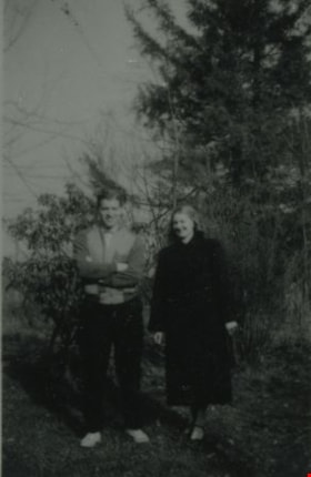
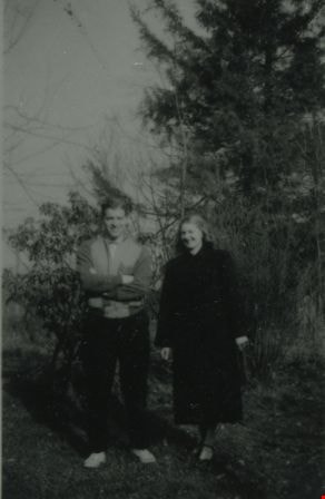
- Photograph of [first name unknown] O'Connor and Bob Pontifex at the back of 4006 Douglas Road (old numbering) and Gilpin Street. Bob Pontifex is in uniform.
- Repository
- City of Burnaby Archives
- Date
- [1941] (date of original), copied 1991
- Collection/Fonds
- Burnaby Historical Society fonds
- Subseries
- Burnaby Image Bank subseries
- Physical Description
- 1 photograph : b&w ; 4.1 x 3.0 cm print on contact sheet 20.7 x 26.5 cm
- Description Level
- Item
- Record No.
- 370-508
- Access Restriction
- No restrictions
- Reproduction Restriction
- No known restrictions
- Accession Number
- BHS1999-03
- Scope and Content
- Photograph of [first name unknown] O'Connor and Bob Pontifex at the back of 4006 Douglas Road (old numbering) and Gilpin Street. Bob Pontifex is in uniform.
- Subjects
- Clothing - Military Uniforms
- Names
- O'Connor, Ms.
- Pontifex, Bob
- Media Type
- Photograph
- Notes
- Title based on contents of photograph
- 1 b&w copy negative accompanying
- Negative has a pink cast
- Geographic Access
- Gilpin Street
- Historic Neighbourhood
- Burnaby Lake (Historic Neighbourhood)
- Planning Study Area
- Douglas-Gilpin Area
Images
![Bob Pontifex and friend, [1941] (date of original), copied 1991 thumbnail](/media/hpo/_Data/_Archives_Images/_Unrestricted/370/370-508.jpg)