Narrow Results By
Subject
- Aerial Photographs 9
- Agriculture - Farms 1
- Animals - Dogs 1
- Buildings - Industrial 1
- Buildings - Industrial - Refineries 1
- Buildings - Residential - Houses 1
- Clothing 1
- Events - Parades 5
- Geographic Features - Automobile Parking Lots 1
- Geographic Features - Bogs 1
- Geographic Features - Roads 1
- Government - Provincial Government 7
Creator
- Bailey, Charles 1
- Bancroft, Rose 1
- British Columbia Government Photograph 1
- Burnaby Art Gallery 1
- City of Burnaby 2
- Commercial Illustrators Industrial Photographers 1
- Hudson's Bay Company 1
- Industrial Photographers 1
- MacSorley, Charles W. 1
- Outram, George 5
- Province of British Columbia 8
- Simnett, Hazel 1
![Freeway at the Willingdon Avenue exit, [1955] thumbnail](/media/hpo/_Data/_Archives_Images/_Unrestricted/480/480-283.jpg?width=280)
Freeway at the Willingdon Avenue exit
https://search.heritageburnaby.ca/link/archivedescription45388
- Repository
- City of Burnaby Archives
- Date
- [1955]
- Collection/Fonds
- Columbian Newspaper collection
- Description Level
- Item
- Physical Description
- 1 photograph : b&w ; 20 x 24.5 cm
- Scope and Content
- Photograph of the Freeway, now named the Trans Canada Highway, near the Willingdon Avenue exit.
- Repository
- City of Burnaby Archives
- Date
- [1955]
- Collection/Fonds
- Columbian Newspaper collection
- Physical Description
- 1 photograph : b&w ; 20 x 24.5 cm
- Description Level
- Item
- Record No.
- 480-283
- Access Restriction
- No restrictions
- Reproduction Restriction
- No restrictions
- Accession Number
- 2003-02
- Scope and Content
- Photograph of the Freeway, now named the Trans Canada Highway, near the Willingdon Avenue exit.
- Subjects
- Geographic Features - Roads
- Media Type
- Photograph
- Photographer
- British Columbia Government Photograph
- Notes
- Title based on contents of photograph
- Photographer identifies photograph as no. H - 1869
- Geographic Access
- Trans Canada Highway
- Willingdon Avenue
- Historic Neighbourhood
- Broadview (Historic Neighbourhood)
- Planning Study Area
- Cascade-Schou Area
Images
![Freeway at the Willingdon Avenue exit, [1955] thumbnail](/media/hpo/_Data/_Archives_Images/_Unrestricted/480/480-283.jpg)
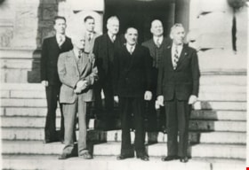
CCF Opposition Members
https://search.heritageburnaby.ca/link/archivedescription35647
- Repository
- City of Burnaby Archives
- Date
- 1951
- Collection/Fonds
- Burnaby Historical Society fonds
- Description Level
- Item
- Physical Description
- 1 photograph : b&w ; 12.7 x 17.8 cm print
- Scope and Content
- Photograph of the CCF (Co-operative Commonwealth Federation) opposition members of the B.C. Legislature. Front row, left to right: Ernie Winch (MLA), Harold Winch (MLA), and Arthur Turner (MLA). Back, left to right: Ran Harding (MLA), Frank Calder (MLA), Rupert Haggen (MLA), and Leo Nimsick, Vict…
- Repository
- City of Burnaby Archives
- Date
- 1951
- Collection/Fonds
- Burnaby Historical Society fonds
- Subseries
- Pioneer Tales subseries
- Physical Description
- 1 photograph : b&w ; 12.7 x 17.8 cm print
- Description Level
- Item
- Record No.
- 204-505
- Access Restriction
- No restrictions
- Reproduction Restriction
- Reproduce for fair dealing purposes only
- Accession Number
- BHS1988-03
- Scope and Content
- Photograph of the CCF (Co-operative Commonwealth Federation) opposition members of the B.C. Legislature. Front row, left to right: Ernie Winch (MLA), Harold Winch (MLA), and Arthur Turner (MLA). Back, left to right: Ran Harding (MLA), Frank Calder (MLA), Rupert Haggen (MLA), and Leo Nimsick, Victoria. Ernie Winch was Leader of the Opposition. He and his son, Harold Winch, set a Guinness world record for the longest father-and-son parliamentary tenure. Frank Calder was the First Status Indian elected to the Legislature.
- Names
- Calder, Frank
- Haggen, Rupert
- Harding, Ran
- Nimsick, Leo
- Turner, Arthur
- Winch, Ernest "Ernie"
- Winch, Harold Edward
- Media Type
- Photograph
- Notes
- Title based on contents of photograph
Images

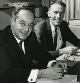
Emmet J. Cafferky and Robert W. Prittie
https://search.heritageburnaby.ca/link/archivedescription45357
- Repository
- City of Burnaby Archives
- Date
- 1968
- Collection/Fonds
- Columbian Newspaper collection
- Description Level
- Item
- Physical Description
- 1 photograph : b&w ; 21 x 20.5 cm
- Scope and Content
- Photograph of Emmet J. Cafferky and Robert W. Prittie when they were running against each other for Mayor of Burnaby. Emmet J. Cafferky was a Burnaby Alderman from 1957 to 1958, and again from 1963 to 1966. Robert Prittie was a New Democrat Member of Parliament from Burnaby-Richmond from 1962 to 19…
- Repository
- City of Burnaby Archives
- Date
- 1968
- Collection/Fonds
- Columbian Newspaper collection
- Physical Description
- 1 photograph : b&w ; 21 x 20.5 cm
- Description Level
- Item
- Record No.
- 480-252
- Access Restriction
- No restrictions
- Reproduction Restriction
- Reproduce for fair dealing purposes only
- Accession Number
- 2003-02
- Scope and Content
- Photograph of Emmet J. Cafferky and Robert W. Prittie when they were running against each other for Mayor of Burnaby. Emmet J. Cafferky was a Burnaby Alderman from 1957 to 1958, and again from 1963 to 1966. Robert Prittie was a New Democrat Member of Parliament from Burnaby-Richmond from 1962 to 1968 and mayor of Burnaby from 1969 to 1973.
- Subjects
- Government - Provincial Government
- Officials - Mayors and Reeves
- Officials - Alderman and Councillors
- Media Type
- Photograph
- Notes
- Title based on contents of photograph
Images
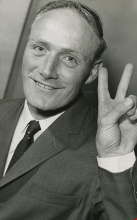
Eric Greenwood
https://search.heritageburnaby.ca/link/archivedescription45267
- Repository
- City of Burnaby Archives
- Date
- 1962
- Collection/Fonds
- Columbian Newspaper collection
- Description Level
- Item
- Physical Description
- 1 photograph : b&w ; 15 x 9.5 cm
- Scope and Content
- Photograph of Eric Greenwood smiling, with his hand in the form of a peace sign. He was the Progressive Conservative candidate for the Burnaby-Coquiltam federal riding for the by-election held on October 22, 1962.
- Repository
- City of Burnaby Archives
- Date
- 1962
- Collection/Fonds
- Columbian Newspaper collection
- Physical Description
- 1 photograph : b&w ; 15 x 9.5 cm
- Description Level
- Item
- Record No.
- 480-163
- Access Restriction
- No restrictions
- Reproduction Restriction
- Reproduce for fair dealing purposes only
- Accession Number
- 2003-02
- Scope and Content
- Photograph of Eric Greenwood smiling, with his hand in the form of a peace sign. He was the Progressive Conservative candidate for the Burnaby-Coquiltam federal riding for the by-election held on October 22, 1962.
- Subjects
- Government - Provincial Government
- Media Type
- Photograph
- Notes
- Title based on contents of photograph
Images

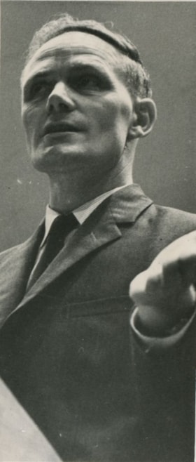
Eric Greenwood giving a speech
https://search.heritageburnaby.ca/link/archivedescription45266
- Repository
- City of Burnaby Archives
- Date
- 1962
- Collection/Fonds
- Columbian Newspaper collection
- Description Level
- Item
- Physical Description
- 1 photograph : b&w ; 10 x 4.5 cm
- Scope and Content
- Photograph of Eric Greenwood giving a speech.He was the Progressive Conservative candidate for the Burnaby-Coquiltam federal riding for the by-election held on October 22, 1962.
- Repository
- City of Burnaby Archives
- Date
- 1962
- Collection/Fonds
- Columbian Newspaper collection
- Physical Description
- 1 photograph : b&w ; 10 x 4.5 cm
- Description Level
- Item
- Record No.
- 480-162
- Access Restriction
- No restrictions
- Reproduction Restriction
- Reproduce for fair dealing purposes only
- Accession Number
- 2003-02
- Scope and Content
- Photograph of Eric Greenwood giving a speech.He was the Progressive Conservative candidate for the Burnaby-Coquiltam federal riding for the by-election held on October 22, 1962.
- Subjects
- Government - Provincial Government
- Media Type
- Photograph
- Notes
- Title based on contents of photograph
Images

![Fred Vulliamy, [1968], published October 21, 1968 thumbnail](/media/hpo/_Data/_Archives_Images/_Unrestricted/480/480-173.jpg?width=280)
Fred Vulliamy
https://search.heritageburnaby.ca/link/archivedescription45277
- Repository
- City of Burnaby Archives
- Date
- [1968], published October 21, 1968
- Collection/Fonds
- Columbian Newspaper collection
- Description Level
- Item
- Physical Description
- 1 photograph : b&w ; 7.5 x 4.5 cm
- Scope and Content
- Photograph of Frederick Justin Vulliamy the New Democratic Party's Member of the Legislative Assembly (MLA) for Burnaby-Willingdon from 1966 until his death in 1968.
- Repository
- City of Burnaby Archives
- Date
- [1968], published October 21, 1968
- Collection/Fonds
- Columbian Newspaper collection
- Physical Description
- 1 photograph : b&w ; 7.5 x 4.5 cm
- Description Level
- Item
- Record No.
- 480-173
- Access Restriction
- No restrictions
- Reproduction Restriction
- Reproduce for fair dealing purposes only
- Accession Number
- 2003-02
- Scope and Content
- Photograph of Frederick Justin Vulliamy the New Democratic Party's Member of the Legislative Assembly (MLA) for Burnaby-Willingdon from 1966 until his death in 1968.
- Subjects
- Government - Provincial Government
- Media Type
- Photograph
- Notes
- Title based on contents of photograph
Images
![Fred Vulliamy, [1968], published October 21, 1968 thumbnail](/media/hpo/_Data/_Archives_Images/_Unrestricted/480/480-173.jpg)
![Fred Vulliamy, [1960] thumbnail](/media/hpo/_Data/_Archives_Images/_Unrestricted/480/480-174.jpg?width=280)
Fred Vulliamy
https://search.heritageburnaby.ca/link/archivedescription45278
- Repository
- City of Burnaby Archives
- Date
- [1960]
- Collection/Fonds
- Columbian Newspaper collection
- Description Level
- Item
- Physical Description
- 1 photograph : b&w ; 5 x 3.5 cm
- Scope and Content
- Photograph of Frederick Justin Vulliamy the New Democratic Party's Member of the Legislative Assembly (MLA) for Burnaby-Willingdon from 1966 until his death in 1968.
- Repository
- City of Burnaby Archives
- Date
- [1960]
- Collection/Fonds
- Columbian Newspaper collection
- Physical Description
- 1 photograph : b&w ; 5 x 3.5 cm
- Description Level
- Item
- Record No.
- 480-174
- Access Restriction
- No restrictions
- Reproduction Restriction
- Reproduce for fair dealing purposes only
- Accession Number
- 2003-02
- Scope and Content
- Photograph of Frederick Justin Vulliamy the New Democratic Party's Member of the Legislative Assembly (MLA) for Burnaby-Willingdon from 1966 until his death in 1968.
- Subjects
- Government - Provincial Government
- Media Type
- Photograph
- Notes
- Title based on contents of photograph
Images
![Fred Vulliamy, [1960] thumbnail](/media/hpo/_Data/_Archives_Images/_Unrestricted/480/480-174.jpg)
![Hugh Walker, [1969] thumbnail](/media/hpo/_Data/_Archives_Images/_Unrestricted/480/480-171.jpg?width=280)
Hugh Walker
https://search.heritageburnaby.ca/link/archivedescription45275
- Repository
- City of Burnaby Archives
- Date
- [1969]
- Collection/Fonds
- Columbian Newspaper collection
- Description Level
- Item
- Physical Description
- 1 photograph : b&w ; 10.5 x 7.5 cm
- Scope and Content
- Photograph of Hugh Walker the Social Credit Candidate for Burnaby-North in the 1969 election.
- Repository
- City of Burnaby Archives
- Date
- [1969]
- Collection/Fonds
- Columbian Newspaper collection
- Physical Description
- 1 photograph : b&w ; 10.5 x 7.5 cm
- Description Level
- Item
- Record No.
- 480-171
- Access Restriction
- No restrictions
- Reproduction Restriction
- Reproduce for fair dealing purposes only
- Accession Number
- 2003-02
- Scope and Content
- Photograph of Hugh Walker the Social Credit Candidate for Burnaby-North in the 1969 election.
- Subjects
- Government - Provincial Government
- Media Type
- Photograph
- Photographer
- Hudson's Bay Company
- Notes
- Title based on contents of photograph
Images
![Hugh Walker, [1969] thumbnail](/media/hpo/_Data/_Archives_Images/_Unrestricted/480/480-171.jpg)
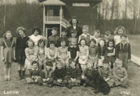
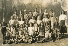
Seaforth School Class
https://search.heritageburnaby.ca/link/archivedescription37341
- Repository
- City of Burnaby Archives
- Date
- 1950
- Collection/Fonds
- Burnaby Historical Society fonds
- Description Level
- Item
- Physical Description
- 1 photograph : b&w ; 12.5 x 17.7 cm
- Scope and Content
- Photograph of twenty-seven students and their teacher seated and standing in rows in front of the school building. A black dog is sitting in the front, facing the rows of children. A label on the back of the photograph states that the students are from Seaforth School. Identified in the photograp…
- Repository
- City of Burnaby Archives
- Date
- 1950
- Collection/Fonds
- Burnaby Historical Society fonds
- Subseries
- Seaforth School subseries
- Physical Description
- 1 photograph : b&w ; 12.5 x 17.7 cm
- Description Level
- Item
- Record No.
- 355-005
- Access Restriction
- No restrictions
- Reproduction Restriction
- Reproduce for fair dealing purposes only
- Accession Number
- BHS1997-14
- Scope and Content
- Photograph of twenty-seven students and their teacher seated and standing in rows in front of the school building. A black dog is sitting in the front, facing the rows of children. A label on the back of the photograph states that the students are from Seaforth School. Identified in the photograph are: Mrs. Mary Johnson (nee MacDonald) teacher, in the far back. Back row (l to r): Sandra ?, Shirley Colden, Marcia Noel, Eldon Clarke, Billy Beaton, David Park, Graeme Smith, Calvert Broomfield, Leigh Tucker and Lillian Savage. Middle row (l to r): Sharon Milne, Gail Simpson, Thelma Mornes, Joan Dachiuk, Barbara Smith, Betty Hadfield, Judy Haddon, Wilma Heather, Merle Beaton and Sammy Savage. Front row (l to r): Dennis Dachiuk, Jerry Hadfield, Mike Lawrence, David MacPhail, Sydney Clarke, Joe Haddon and Jerry Green.
- Subjects
- Animals - Dogs
- Occupations - Teachers
- Names
- Seaforth School
- Johnson, Mary MacDonald
- Colden, Shirley
- Noel, Marcia
- Clarke, Eldon
- Beaton, Billy
- Park, David
- Smith, Graeme
- Broomfield, Calvert
- Tucker, Leigh
- Savage, Lillian
- Anderson, Gail
- Sampson, Gail
- Mornes, Thelma
- Dachiuk, Joan
- Smith, Barbara
- Hadfield, Betty
- Haddon, Judy
- Heather, Wilma
- Beaton, Merle
- Savage, Sammy
- Dachiuk, Dennis
- Hadfield, Jerry
- Lawrence, Mike
- MacPhail, David
- Clarke, Sydney
- Haddon, Joe
- Green, Jerry
- Media Type
- Photograph
- Notes
- Title based on label on verso of photograph
- Photographer identified as "Layton"
- Geographic Access
- Government Road
- Deer Lake Avenue
- Street Address
- 7881 Government Road
- 6501 Deer Lake Avenue
- Historic Neighbourhood
- Lozells (Historic Neighbourhood)
- Planning Study Area
- Government Road Area
Images
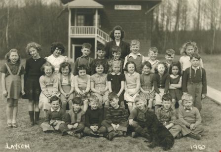
Seaforth School Class
https://search.heritageburnaby.ca/link/archivedescription37342
- Repository
- City of Burnaby Archives
- Date
- 1951
- Collection/Fonds
- Burnaby Historical Society fonds
- Description Level
- Item
- Physical Description
- 1 photograph : b&w ; 12.7 x 17.7 cm
- Scope and Content
- Photograph of twenty-seven students and their teacher seated and standing in rows outside. A label on the back of the photograph states that the students are from Seaforth School. Identified are as follows: Mrs. Mary Johnson (nee MacDonald) teacher, far right. Back row (l to r): Glen Richardson,…
- Repository
- City of Burnaby Archives
- Date
- 1951
- Collection/Fonds
- Burnaby Historical Society fonds
- Subseries
- Seaforth School subseries
- Physical Description
- 1 photograph : b&w ; 12.7 x 17.7 cm
- Description Level
- Item
- Record No.
- 355-006
- Access Restriction
- No restrictions
- Reproduction Restriction
- Reproduce for fair dealing purposes only
- Accession Number
- BHS1997-14
- Scope and Content
- Photograph of twenty-seven students and their teacher seated and standing in rows outside. A label on the back of the photograph states that the students are from Seaforth School. Identified are as follows: Mrs. Mary Johnson (nee MacDonald) teacher, far right. Back row (l to r): Glen Richardson, Leigh Tucker, Brian Clarke, Sammy Savage, Eldon Clarke, David Park, Tommy Richardson, and Joe Haddon. Second row (l to r): Mike Lawrence (standing to the left), Sandra ?, Joan Olsen, Betty Hadfield, Donna Anderson, Wilma Heather, Barbara Smith, Gail Simpson and Shirley Colden. Third row (l to r): Lois Brown, Jackie Peskett, Gail Anderson, Joan Pescott, Merle Beaton, Judy Haddon, Joan Dachiuk, Thelma Mornes, and Jerry Hadfield (standing to the right). Front row (l to r): Dennis Dachiuk, Roy Olsen, David ?, Allen Beaton, Sydney Clarke, David McPhail, and Terry Burstyk.
- Subjects
- Occupations - Teachers
- Names
- Seaforth School
- Johnson, Mary MacDonald
- Richardson, Glen
- Tucker, Leigh
- Clarke, Brian
- Savage, Sammy
- Clarke, Eldon
- Park, David
- Richardson, Tommy
- Haddon, Joe
- Lawrence, Mike
- Olsen, Joan
- Hadfield, Betty
- Anderson, Donna
- Heather, Wilma
- Smith, Barbara
- Sampson, Gail
- Colden, Shirley
- Brown, Lois
- Peskett, Jackie
- Anderson, Gail
- Pescott, Joan
- Beaton, Merle
- Haddon, Judy
- Dachiuk, Joan
- Mornes, Thelma
- Hadfield, Jerry
- Dachiuk, Dennis
- Olsen, Roy
- Beaton, Allen
- Clarke, Sydney
- MacPhail, David
- Burstyk, Terry
- Media Type
- Photograph
- Notes
- Title based on label on verso of photograph
- Photographer identified as "Layton"
- Geographic Access
- Government Road
- Deer Lake Avenue
- Street Address
- 7881 Government Road
- 6501 Deer Lake Avenue
- Historic Neighbourhood
- Lozells (Historic Neighbourhood)
- Planning Study Area
- Government Road Area
Images


Abandonded farm house
https://search.heritageburnaby.ca/link/archivedescription36511
- Repository
- City of Burnaby Archives
- Date
- 1950
- Collection/Fonds
- Burnaby Historical Society fonds
- Description Level
- Item
- Physical Description
- 1 photograph : b&w ; 8.5 x 14 cm
- Scope and Content
- Photograph of an abandoned farm house on Government Road.
- Repository
- City of Burnaby Archives
- Date
- 1950
- Collection/Fonds
- Burnaby Historical Society fonds
- Subseries
- Photographs subseries
- Physical Description
- 1 photograph : b&w ; 8.5 x 14 cm
- Description Level
- Item
- Record No.
- 288-002
- Access Restriction
- No restrictions
- Reproduction Restriction
- Reproduce for fair dealing purposes only
- Accession Number
- BHS1992-23
- Scope and Content
- Photograph of an abandoned farm house on Government Road.
- Media Type
- Photograph
- Notes
- Title based on contents of photograph
- Photograph is a modern contact print of an original negative that was loaned to the Archives
- Geographic Access
- Government Road
- Historic Neighbourhood
- Lochdale (Historic Neighbourhood)
- Planning Study Area
- Government Road Area
Images

Aerial photograph of Burnaby
https://search.heritageburnaby.ca/link/archivedescription84892
- Repository
- City of Burnaby Archives
- Date
- 1963
- Collection/Fonds
- Allan Amundsen collection
- Description Level
- Item
- Physical Description
- 1 photograph : b&w ; 22.5 x 22.5 cm
- Scope and Content
- Aerial photograph of Burnaby north of Lougheed Highway.
- Repository
- City of Burnaby Archives
- Date
- 1963
- Collection/Fonds
- Allan Amundsen collection
- Physical Description
- 1 photograph : b&w ; 22.5 x 22.5 cm
- Description Level
- Item
- Record No.
- 561-013
- Access Restriction
- In Archives only
- Reproduction Restriction
- No reproduction permitted
- Accession Number
- 2014-08
- Scope and Content
- Aerial photograph of Burnaby north of Lougheed Highway.
- Subjects
- Aerial Photographs
- Media Type
- Photograph
- Photographer
- Province of British Columbia
- Notes
- Title based on contents of photograph
- This photo is indentified as BC5061:118 and connects with B.C. air photograph BC5061:117 to the west and BC5061:119 to the east
- Historic Neighbourhood
- Burnaby Lake (Historic Neighbourhood)
- Lozells (Historic Neighbourhood)
- Planning Study Area
- Parkcrest-Aubrey Area
- Ardingley-Sprott Area
- Sperling-Broadway Area
- Government Road Area
Aerial photograph of Burnaby
https://search.heritageburnaby.ca/link/archivedescription84893
- Repository
- City of Burnaby Archives
- Date
- 1963
- Collection/Fonds
- Allan Amundsen collection
- Description Level
- Item
- Physical Description
- 1 photograph : b&w ; 22.5 x 22.5 cm
- Scope and Content
- Aerial photograph of Burnaby north of Lougheed Highway and west of Sperling Avenue.
- Repository
- City of Burnaby Archives
- Date
- 1963
- Collection/Fonds
- Allan Amundsen collection
- Physical Description
- 1 photograph : b&w ; 22.5 x 22.5 cm
- Description Level
- Item
- Record No.
- 561-014
- Access Restriction
- In Archives only
- Reproduction Restriction
- No reproduction permitted
- Accession Number
- 2014-08
- Scope and Content
- Aerial photograph of Burnaby north of Lougheed Highway and west of Sperling Avenue.
- Subjects
- Aerial Photographs
- Media Type
- Photograph
- Photographer
- Province of British Columbia
- Notes
- Title based on contents of photograph
- This photo is indentified as BC5061:119 and connects with B.C. air photograph BC5061:118 to the west and BC5061:120 to the east
- Geographic Access
- Burnaby Mountain Conservation Area
- Historic Neighbourhood
- Lozells (Historic Neighbourhood)
- Planning Study Area
- Sperling-Broadway Area
- Lake City Area
- Government Road Area
Aerial photograph of Burnaby
https://search.heritageburnaby.ca/link/archivedescription84894
- Repository
- City of Burnaby Archives
- Date
- 1963
- Collection/Fonds
- Allan Amundsen collection
- Description Level
- Item
- Physical Description
- 1 photograph : b&w ; 22.5 x 22.5 cm
- Scope and Content
- Aerial photograph of Burnaby north of Broadway and west of Sperling Avenue.
- Repository
- City of Burnaby Archives
- Date
- 1963
- Collection/Fonds
- Allan Amundsen collection
- Physical Description
- 1 photograph : b&w ; 22.5 x 22.5 cm
- Description Level
- Item
- Record No.
- 561-015
- Access Restriction
- In Archives only
- Reproduction Restriction
- No reproduction permitted
- Accession Number
- 2014-08
- Scope and Content
- Aerial photograph of Burnaby north of Broadway and west of Sperling Avenue.
- Subjects
- Aerial Photographs
- Media Type
- Photograph
- Photographer
- Province of British Columbia
- Notes
- Title based on contents of photograph
- This photo is indentified as BC5061:120 and connects with B.C. air photograph BC5061:119 to the west and BC5061:121 to the east
- Geographic Access
- Burnaby Mountain Conservation Area
- Historic Neighbourhood
- Lozells (Historic Neighbourhood)
- Planning Study Area
- Sperling-Broadway Area
- Lake City Area
- Government Road Area
- Burnaby Mountain Area
Aerial photograph of Burnaby
https://search.heritageburnaby.ca/link/archivedescription84896
- Repository
- City of Burnaby Archives
- Date
- 1963
- Collection/Fonds
- Allan Amundsen collection
- Description Level
- Item
- Physical Description
- 1 photograph : b&w ; 22.5 x 22.5 cm
- Scope and Content
- Aerial photograph of Burnaby north of Broadway and west of Sperling Avenue.
- Repository
- City of Burnaby Archives
- Date
- 1963
- Collection/Fonds
- Allan Amundsen collection
- Physical Description
- 1 photograph : b&w ; 22.5 x 22.5 cm
- Description Level
- Item
- Record No.
- 561-016
- Access Restriction
- In Archives only
- Reproduction Restriction
- No reproduction permitted
- Accession Number
- 2014-08
- Scope and Content
- Aerial photograph of Burnaby north of Broadway and west of Sperling Avenue.
- Subjects
- Aerial Photographs
- Media Type
- Photograph
- Photographer
- Province of British Columbia
- Notes
- Title based on contents of photograph
- This photo is indentified as BC5061:121 and connects with B.C. air photograph BC5061:120 to the west and BC5061:122 to the east
- Geographic Access
- Burnaby Mountain Conservation Area
- Historic Neighbourhood
- Lozells (Historic Neighbourhood)
- Planning Study Area
- Sperling-Broadway Area
- Lake City Area
- Government Road Area
- Burnaby Mountain Area
Aerial photograph of Burnaby
https://search.heritageburnaby.ca/link/archivedescription84911
- Repository
- City of Burnaby Archives
- Date
- 1963
- Collection/Fonds
- Allan Amundsen collection
- Description Level
- Item
- Physical Description
- 1 photograph : b&w ; 22.5 x 22.5 cm
- Scope and Content
- Aerial photograph of Burnaby with Lougheed Highway running west to east through the middle of the photograph and the Trans Canada Highway in the lower left segment.
- Repository
- City of Burnaby Archives
- Date
- 1963
- Collection/Fonds
- Allan Amundsen collection
- Physical Description
- 1 photograph : b&w ; 22.5 x 22.5 cm
- Description Level
- Item
- Record No.
- 561-029
- Access Restriction
- In Archives only
- Reproduction Restriction
- No reproduction permitted
- Accession Number
- 2014-08
- Scope and Content
- Aerial photograph of Burnaby with Lougheed Highway running west to east through the middle of the photograph and the Trans Canada Highway in the lower left segment.
- Subjects
- Aerial Photographs
- Media Type
- Photograph
- Photographer
- Province of British Columbia
- Notes
- Title based on contents of photograph
- This photo is indentified as BC5062:22 and connects with B.C. air photograph BC5062:23 to the west and B.C. air photograph BC5062:21
- Historic Neighbourhood
- Lozells (Historic Neighbourhood)
- Burquitlam (Historic Neighbourhood)
- Planning Study Area
- Lake City Area
- Government Road Area
- Burnaby Lake Area
- Lyndhurst Area
- Cariboo-Armstrong Area
Aerial photograph of Burnaby Lake Area
https://search.heritageburnaby.ca/link/archivedescription84908
- Repository
- City of Burnaby Archives
- Date
- 1963
- Collection/Fonds
- Allan Amundsen collection
- Description Level
- Item
- Physical Description
- 1 photograph : b&w ; 22.5 x 22.5 cm
- Scope and Content
- Aerial photograph of Burnaby with Lougheed Highway in the north west corner, the Trans Canada Highway in the south east corner and Burnaby Lake appearing from the west.
- Repository
- City of Burnaby Archives
- Date
- 1963
- Collection/Fonds
- Allan Amundsen collection
- Physical Description
- 1 photograph : b&w ; 22.5 x 22.5 cm
- Description Level
- Item
- Record No.
- 561-026
- Access Restriction
- In Archives only
- Reproduction Restriction
- No reproduction permitted
- Accession Number
- 2014-08
- Scope and Content
- Aerial photograph of Burnaby with Lougheed Highway in the north west corner, the Trans Canada Highway in the south east corner and Burnaby Lake appearing from the west.
- Subjects
- Aerial Photographs
- Media Type
- Photograph
- Photographer
- Province of British Columbia
- Notes
- Title based on contents of photograph
- This photo is indentified as BC5062:25 and connects with B.C. air photograph BC5062:26 to the west and B.C. air photograph BC5062:24 to the east
- Historic Neighbourhood
- Burnaby Lake (Historic Neighbourhood)
- Lozells (Historic Neighbourhood)
- Planning Study Area
- Douglas-Gilpin Area
- Sperling-Broadway Area
- Government Road Area
- Burnaby Lake Area
Aerial photograph of Burnaby Lake Area
https://search.heritageburnaby.ca/link/archivedescription84909
- Repository
- City of Burnaby Archives
- Date
- 1963
- Collection/Fonds
- Allan Amundsen collection
- Description Level
- Item
- Physical Description
- 1 photograph : b&w ; 22.5 x 22.5 cm
- Scope and Content
- Aerial photograph of Burnaby with Lougheed Highway to the north and Burnaby Lake to the south.
- Repository
- City of Burnaby Archives
- Date
- 1963
- Collection/Fonds
- Allan Amundsen collection
- Physical Description
- 1 photograph : b&w ; 22.5 x 22.5 cm
- Description Level
- Item
- Record No.
- 561-027
- Access Restriction
- In Archives only
- Reproduction Restriction
- No reproduction permitted
- Accession Number
- 2014-08
- Scope and Content
- Aerial photograph of Burnaby with Lougheed Highway to the north and Burnaby Lake to the south.
- Subjects
- Aerial Photographs
- Media Type
- Photograph
- Photographer
- Province of British Columbia
- Notes
- Title based on contents of photograph
- This photo is indentified as BC5062:24 and connects with B.C. air photograph BC5062:25 to the west and B.C. air photograph BC5062:23 to the east
- Historic Neighbourhood
- Burnaby Lake (Historic Neighbourhood)
- Lozells (Historic Neighbourhood)
- Planning Study Area
- Douglas-Gilpin Area
- Sperling-Broadway Area
- Government Road Area
- Burnaby Lake Area
Aerial photograph of Burnaby Lake Area
https://search.heritageburnaby.ca/link/archivedescription84910
- Repository
- City of Burnaby Archives
- Date
- 1963
- Collection/Fonds
- Allan Amundsen collection
- Description Level
- Item
- Physical Description
- 1 photograph : b&w ; 22.5 x 22.5 cm
- Scope and Content
- Aerial photograph of Burnaby with Burnaby Lake to the south and Broadway to the north.
- Repository
- City of Burnaby Archives
- Date
- 1963
- Collection/Fonds
- Allan Amundsen collection
- Physical Description
- 1 photograph : b&w ; 22.5 x 22.5 cm
- Description Level
- Item
- Record No.
- 561-028
- Access Restriction
- In Archives only
- Reproduction Restriction
- No reproduction permitted
- Accession Number
- 2014-08
- Scope and Content
- Aerial photograph of Burnaby with Burnaby Lake to the south and Broadway to the north.
- Subjects
- Aerial Photographs
- Media Type
- Photograph
- Photographer
- Province of British Columbia
- Notes
- Title based on contents of photograph
- This photo is indentified as BC5062:23 and connects with B.C. air photograph BC5062:24 to the west and B.C. air photograph BC5062:22 to the east
- Historic Neighbourhood
- Burnaby Lake (Historic Neighbourhood)
- Lozells (Historic Neighbourhood)
- Planning Study Area
- Lake City Area
- Government Road Area
- Burnaby Lake Area
![Lenkurt Electric Company, [1957] thumbnail](/media/Hpo/_Data/_Archives_Images/_Unrestricted/001/099-001.jpg?width=280)
Lenkurt Electric Company
https://search.heritageburnaby.ca/link/archivedescription34690
- Repository
- City of Burnaby Archives
- Date
- [1957]
- Collection/Fonds
- Burnaby Historical Society fonds
- Description Level
- Item
- Physical Description
- 1 photograph : b&w ; 20.3 x 25.3 cm
- Scope and Content
- Photograph of aerial view of the Lenkurt Electric Company at 6960 Lougheed Highway (later renumbered 7018 Lougheed Highway). A sign on the top of the building reads, "Lenkurt." An information sheet from the Company Relation Division of Lenkurt attached to the back of the photograph reads, "Aerial…
- Repository
- City of Burnaby Archives
- Date
- [1957]
- Collection/Fonds
- Burnaby Historical Society fonds
- Subseries
- Photographs subseries
- Physical Description
- 1 photograph : b&w ; 20.3 x 25.3 cm
- Description Level
- Item
- Record No.
- 099-001
- Access Restriction
- No restrictions
- Reproduction Restriction
- Reproduce for fair dealing purposes only
- Accession Number
- BHS2007-04
- Scope and Content
- Photograph of aerial view of the Lenkurt Electric Company at 6960 Lougheed Highway (later renumbered 7018 Lougheed Highway). A sign on the top of the building reads, "Lenkurt." An information sheet from the Company Relation Division of Lenkurt attached to the back of the photograph reads, "Aerial view of a 34,000 square foot building including a 19,000 square foot extension to the existing 15,000 square foot plant of Lenkurt Electric Co. of Canada Ltd. in North Burnaby, B.C., as at May 10th, 1957. / The building is situated on 20 acres of land and faces north onto Lougheed Highway."
- Names
- Lenkurt Electric Company
- Media Type
- Photograph
- Photographer
- Commercial Illustrators Industrial Photographers
- Notes
- Title based on contents of photograph
- Stamp and annotation on back of photograph reads, "TA. 8817 / Commerical Illustrators / Industrial Photographers / 601 Denman St., Vancouver 5, B.C. / File No. 1080-1"
- Geographic Access
- Lougheed Highway
- Street Address
- 7018 Lougheed Highway
- Historic Neighbourhood
- Lozells (Historic Neighbourhood)
- Planning Study Area
- Government Road Area
Images
![Lenkurt Electric Company, [1957] thumbnail](/media/Hpo/_Data/_Archives_Images/_Unrestricted/001/099-001.jpg)