Narrow Results By
Subject
- Aerial Photographs 1
- Agriculture - Farms 1
- Agriculture - Fruit and Berries 1
- Animals - Bears 1
- Animals - Birds 2
- Animals - Deer 1
- Animals - Dogs 1
- Armament - Munitions 1
- Buildings - Civic - Art Galleries 1
- Buildings - Commercial - Grocery Stores 2
- Buildings - Commercial - Train Stations 1
- Buildings - Industrial 1
Creator
- Battistoni, Peter 3
- Bingham, Alfred "Alf" 4
- Brainerd family 1
- British Columbia Electric Company 2
- City of Burnaby 1
- Eagles, Dr. Blythe 1
- Eagles, Dr. Violet 1
- Ehlers, Edith "Edie" Fleming 1
- Ettinger, James Gilmore 1
- Fleming, Frances "Fanny" Waplington 1
- Flückiger, Friedrich A. (Friedrich August), 1828-1894 1
- Green, George, 1872-1955 1
Shell and Standard Oil Plants - Odor Complaints
https://search.heritageburnaby.ca/link/councilreport48585
- Repository
- City of Burnaby Archives
- Report ID
- 48425
- Meeting Date
- 9-Aug-1948
- Format
- Council - Mayor/Councillor/Staff Report
- Collection/Fonds
- City Council and Office of the City Clerk fonds
- Repository
- City of Burnaby Archives
- Report ID
- 48425
- Meeting Date
- 9-Aug-1948
- Format
- Council - Mayor/Councillor/Staff Report
- Collection/Fonds
- City Council and Office of the City Clerk fonds
Documents

McColl-Frontenac Oil Company
https://search.heritageburnaby.ca/link/landmark682
- Repository
- Burnaby Heritage Planning
- Associated Dates
- 1945
- Heritage Value
- In 1945, the McColl-Frontenac Oil Company purchased the western section of what used to be the Barnet Mill site from the City of Burnaby. McColl-Frontenac handled the distribution of Texaco gas and built a new plant at the site for this purpose. The company built an improved road access to the plant which later became known as Texaco Drive. Competition from other refineries eventually forced the closure of this plant and in 1985 the area was acquired by the Municipality for the expansion of Barnet Marine Park.
- Historic Neighbourhood
- Barnet (Historic Neighbourhood)
- Planning Study Area
- Burnaby Mountain Area
Images


Brentwood Neighbourhood
https://search.heritageburnaby.ca/link/landmark780
- Repository
- Burnaby Heritage Planning
- Associated Dates
- 1955-2008
- Heritage Value
- Between 1955 and 2001, the Brentwood Neighbourhood developed into one of Burnaby's four official Town Centres. The Brentwood Town Centre serves the north-west sector of the Municipality, providing facilities such as commercial developments - of which the Brentwood Mall is the most significant. Under Burnaby's Residential Development Framework adopted by Council in 1981, the Town Centre also incorporated a full range of multi-housing types and forms in close relationship with their commercial facilities. In 1996, the City adopted the Brentwood Town Centre Development Plant to solidify the area as a focus of higher-density and higher-intensity residential and commercial opportunities, public transit and supporting leisure facilities.
- Planning Study Area
- Brentwood Area
Images


Broadview Neighbourhood
https://search.heritageburnaby.ca/link/landmark687
- Repository
- Burnaby Heritage Planning
- Associated Dates
- 1925-1954
- Heritage Value
- Development in the Broadview area slowed during World War Two, but after the war, the area became home to a number of industrial sites. The first major plant to be built here was the Dominion Bridge Company which opened in 1930.
- Historic Neighbourhood
- Broadview (Historic Neighbourhood)
- Planning Study Area
- Cascade-Schou Area
Images


Kelly-Douglas Company
https://search.heritageburnaby.ca/link/landmark697
- Repository
- Burnaby Heritage Planning
- Geographic Access
- Kingsway
- Associated Dates
- 1946
- Heritage Value
- The Kelly Douglas Company was founded in 1896 as a wholesale grocery business. It enjoyed rapid success during the Klondike Goldrush of 1898 when it became a primary supplier for prospectors. In 1946, its headquarters moved from Vancouver to Burnaby and a manufacturing plant and warehouse was built on the site.
- Historic Neighbourhood
- Central Park (Historic Neighbourhood)
- Planning Study Area
- Maywood Area
- Street Address
- 4700 Kingsway
Images


Shell Oil Company
https://search.heritageburnaby.ca/link/landmark675
- Repository
- Burnaby Heritage Planning
- Geographic Access
- Kensington Avenue
- Associated Dates
- ca. 1930-1993
- Heritage Value
- After considering several sites in the Greater Vancouver area, the Shell Oil Company chose 70 acres in North Burnaby with frontage of one third of a mile on Burrard Inlet. Shell proposed to build a four-million dollar plant that would employ up to 2000 - providing some relief in the middle of Burnaby's economic crisis of the Depression years. The site became known as the Shellburn Refinery and was in operation until 1993.
- Historic Neighbourhood
- Lochdale (Historic Neighbourhood)
- Planning Study Area
- Westridge Area
Images


Rosalie (Moore) Barrett Residence
https://search.heritageburnaby.ca/link/landmark498
- Repository
- Burnaby Heritage Planning
- Description
- The Rosalie (Moore) Barrett Residence is a one-storey ranch-style bungalow with a cross-gabled roofline, located on Sperling Avenue. It is located within the Deer Lake Park Heritage Precinct, and is adjacent to a related house, the Ethel Moore Residence, built the previous year.
- Associated Dates
- 1942
- Street View URL
- Google Maps Street View
- Repository
- Burnaby Heritage Planning
- Geographic Access
- Sperling Avenue
- Associated Dates
- 1942
- Description
- The Rosalie (Moore) Barrett Residence is a one-storey ranch-style bungalow with a cross-gabled roofline, located on Sperling Avenue. It is located within the Deer Lake Park Heritage Precinct, and is adjacent to a related house, the Ethel Moore Residence, built the previous year.
- Heritage Value
- This house is significant for its connection with first owner, Rosalie Barrett, the daughter of Ethel Hutchings Moore, who lived in the adjacent house at 5145 Sperling Avenue. A spacious modernist bungalow, it was constructed in 1942, and was designed by Rosalie Moore herself. Moore intended to build several houses on this property, but further development was curtailed due to wartime restrictions on domestic construction. The Rosalie (Moore) Barrett Residence is a testament to Deer Lake's continued popularity as a residential neighbourhood in the 1940s. Although Burnaby was serviced by a number of transportation links at the time, the increasing availability of automobiles provided improved access to outlying suburbs. Rising real estate prices in Vancouver and New Westminster attracted residents to this neighbourhood because of its relative affordability, central location and beautiful scenery.
- Defining Elements
- Key elements that define the heritage character of the Rosalie (Moore) Barrett Residence include its: - location within the Deer Lake Park Heritage Precinct - residential form, scale and massing as expressed by its one-storey height, rambling linear plan and cross-gabled roof - wood-frame construction with stucco siding and waney-edged boards in the gable peaks - red brick on the front façade and rough-cut granite at the base of the house - Modernist design as exemplified by the asymmetrical, linear plan with low pitched roof - internal granite chimney - original windows, including wooden-sash casement windows in double and triple-assembly with four-part, horizontal leading - original front door with glass block sidelights - associated landscape features such as granite gateposts, foundation plantings and mature coniferous trees
- Historic Neighbourhood
- Burnaby Lake (Historic Neighbourhood)
- Planning Study Area
- Morley-Buckingham Area
- Function
- Primary Historic--Single Dwelling
- Primary Current--Single Dwelling
- Community
- Deer Lake
- Cadastral Identifier
- P.I.D.006-082-696
- Boundaries
- The Rosalie (Moore) Barrett Residence is comprised of a single residential lot located at 5155 Sperling Avenue, Burnaby.
- Area
- 11291.44
- Contributing Resource
- Building
- Ownership
- Public (local)
- Documentation
- City of Burnaby Planning and Building Department, Heritage Site Files
- Street Address
- 5155 Sperling Avenue
- Street View URL
- Google Maps Street View
Images


Progress report
https://search.heritageburnaby.ca/link/museumlibrary7355
- Repository
- Burnaby Village Museum
- Collection
- Reference Collection
- Material Type
- Moving Images
- Call Number
- 388.46 BCH VR
- Contributor
- British Columbia Electric Company
- Place of Publication
- [British Columbia, Canada]
- Publisher
- BC Hydro
- Publication Date
- c1947
- Physical Description
- 1 videodisc (13 min.) : sd., b&w. ; 4 3/4 in.
- Library Subject (LOC)
- Natural gas industry
- Local transit
- Hydroelectric power plants
- Electric railroads
- Electric power-plants
- Transportation
- British Columbia--History
- Subjects
- Transportation
- Geographic Access
- Vancouver
- Notes
- Summary: Promotional film. The BC Electric Railway Company's $50 million post-war expansion and modernization program, to be completed by 1950. Includes: expansion of transit services, including start of the switch from streetcars to trolley buses; water gas plant; explanation of the Bridge River project, with footage of construction (including La Joie Falls storage dam); Lower Mainland power sub-stations. Various Vancouver street scenes, especially Fraser Street and downtown
- Credit note : sponsored/presented by: British Columbia Electric Company; producer: Lew M. Parry; producing agency/company: Trans-Canada Films Ltd.

1982 - Moving the Roberts House
https://search.heritageburnaby.ca/link/archivedescription91880
- Repository
- City of Burnaby Archives
- Date
- 1982
- Collection/Fonds
- Small family fonds
- Description Level
- Item
- Physical Description
- 1 photograph : col. copy print ; 10 cm x 15 cm
- Scope and Content
- Photograph of the land being cleared at 5496 Dominion Street in order to create a path to move the Roberts' house onto the property. Included in the clearing are the stumps of two apples trees, a poplar tree, and a maple tree. The debris from the site was burned and smoke can seen rising from a s…
- Repository
- City of Burnaby Archives
- Date
- 1982
- Collection/Fonds
- Small family fonds
- Physical Description
- 1 photograph : col. copy print ; 10 cm x 15 cm
- Description Level
- Item
- Record No.
- 620-061
- Access Restriction
- No restrictions
- Reproduction Restriction
- No reproduction permitted
- Accession Number
- 2017-01
- Scope and Content
- Photograph of the land being cleared at 5496 Dominion Street in order to create a path to move the Roberts' house onto the property. Included in the clearing are the stumps of two apples trees, a poplar tree, and a maple tree. The debris from the site was burned and smoke can seen rising from a small pile of brush on the right.
- Media Type
- Photograph
- Notes
- Transcribed title
- Title transcribed from donor's notes
- Note in blue ink on verso of photograph reads: "p.3"
- Note in pencil on verso of photograph reads: "2"
- Street Address
- 5496 Dominion Street
- Historic Neighbourhood
- Burnaby Lake (Historic Neighbourhood)
- Planning Study Area
- Ardingley-Sprott Area
Images


1982 - Moving the Roberts House 5538 Dominion Street to its new location at 5496 Dominion Street
https://search.heritageburnaby.ca/link/archivedescription91879
- Repository
- City of Burnaby Archives
- Date
- 1982
- Collection/Fonds
- Small family fonds
- Description Level
- Item
- Physical Description
- 1 photograph : col. ; 9 cm x 13 cm
- Scope and Content
- Photograph of the site at 5496 Dominion Street where the Roberts' house was to be moved. To the left is the old garage that was originally part of the small dwelling the Roberts lived in during the construction of their house in the early 1920s. In the background is 3093 Douglas Road and in the f…
- Repository
- City of Burnaby Archives
- Date
- 1982
- Collection/Fonds
- Small family fonds
- Physical Description
- 1 photograph : col. ; 9 cm x 13 cm
- Description Level
- Item
- Record No.
- 620-060
- Access Restriction
- No restrictions
- Reproduction Restriction
- No reproduction permitted
- Accession Number
- 2017-01
- Scope and Content
- Photograph of the site at 5496 Dominion Street where the Roberts' house was to be moved. To the left is the old garage that was originally part of the small dwelling the Roberts lived in during the construction of their house in the early 1920s. In the background is 3093 Douglas Road and in the foreground are two apple trees planted by John W. Roberts.
- Media Type
- Photograph
- Notes
- Transcribed title
- Title transcribed from donor's notes
- Note in blue ink on verso of photograph reads: "p.2"
- Note in blue ink on verso of photograph reads: "Garage, Poplar Tree and Apple Trees before they had to go to make room to move house here / Spring 1982"
- 5118 Douglas Road renumbered to 3131 Douglas Road in 1958 and to 5538 Dominion Street in 1970 or 1971
- Street Address
- 5496 Dominion Street
- Historic Neighbourhood
- Burnaby Lake (Historic Neighbourhood)
- Planning Study Area
- Ardingley-Sprott Area
Images


6742 Walker Avenue
https://search.heritageburnaby.ca/link/archivedescription37844
- Repository
- City of Burnaby Archives
- Date
- May 1987 (date of original), copied 1991
- Collection/Fonds
- Burnaby Historical Society fonds
- Description Level
- Item
- Physical Description
- 1 photograph : b&w ; 3.1 x 4.3 cm print on contact sheet 20.6 x 26.7 cm
- Scope and Content
- Photograph of 6742 Walker Avenue, with only the trees in the yard visible from the road. A van is parked in front.
- Repository
- City of Burnaby Archives
- Date
- May 1987 (date of original), copied 1991
- Collection/Fonds
- Burnaby Historical Society fonds
- Subseries
- Burnaby Image Bank subseries
- Physical Description
- 1 photograph : b&w ; 3.1 x 4.3 cm print on contact sheet 20.6 x 26.7 cm
- Description Level
- Item
- Record No.
- 370-432
- Access Restriction
- No restrictions
- Reproduction Restriction
- No restrictions
- Accession Number
- BHS1999-03
- Scope and Content
- Photograph of 6742 Walker Avenue, with only the trees in the yard visible from the road. A van is parked in front.
- Subjects
- Plants - Trees
- Media Type
- Photograph
- Notes
- Title based on contents of photograph
- 1 b&w copy negative accompanying
- Negative has a pink cast
- Copied from col. photograph
- Geographic Access
- Walker Avenue
- Street Address
- 6742 Walker Avenue
- Historic Neighbourhood
- Edmonds (Historic Neighbourhood)
- Planning Study Area
- Richmond Park Area
Images


6742 Walker Avenue
https://search.heritageburnaby.ca/link/archivedescription37845
- Repository
- City of Burnaby Archives
- Date
- May 1987 (date of original), copied 1991
- Collection/Fonds
- Burnaby Historical Society fonds
- Description Level
- Item
- Physical Description
- 1 photograph : b&w ; 3.0 x 4.4 cm print on contact sheet 20.6 x 26.7 cm
- Scope and Content
- Photograph of 6742 Walker Avenue with some of the trees in the yard cut down.
- Repository
- City of Burnaby Archives
- Date
- May 1987 (date of original), copied 1991
- Collection/Fonds
- Burnaby Historical Society fonds
- Subseries
- Burnaby Image Bank subseries
- Physical Description
- 1 photograph : b&w ; 3.0 x 4.4 cm print on contact sheet 20.6 x 26.7 cm
- Description Level
- Item
- Record No.
- 370-433
- Access Restriction
- No restrictions
- Reproduction Restriction
- No restrictions
- Accession Number
- BHS1999-03
- Scope and Content
- Photograph of 6742 Walker Avenue with some of the trees in the yard cut down.
- Subjects
- Plants - Trees
- Media Type
- Photograph
- Notes
- Title based on contents of photograph
- 1 b&w copy negative accompanying
- Negative has a pink cast
- Copied from col. photograph
- Geographic Access
- Walker Avenue
- Street Address
- 6742 Walker Avenue
- Historic Neighbourhood
- Edmonds (Historic Neighbourhood)
- Planning Study Area
- Richmond Park Area
Images


6742 Walker Avenue
https://search.heritageburnaby.ca/link/archivedescription37846
- Repository
- City of Burnaby Archives
- Date
- May 1987 (date of original), copied 1991
- Collection/Fonds
- Burnaby Historical Society fonds
- Description Level
- Item
- Physical Description
- 1 photograph : b&w ; 3.0 x 4.3 cm print on contact sheet 20.6 x 26.7 cm
- Scope and Content
- Photograph of 6742 Walker Avenue, showing the stumps of the recently cut down trees in the yard of the house.
- Repository
- City of Burnaby Archives
- Date
- May 1987 (date of original), copied 1991
- Collection/Fonds
- Burnaby Historical Society fonds
- Subseries
- Burnaby Image Bank subseries
- Physical Description
- 1 photograph : b&w ; 3.0 x 4.3 cm print on contact sheet 20.6 x 26.7 cm
- Description Level
- Item
- Record No.
- 370-434
- Access Restriction
- No restrictions
- Reproduction Restriction
- No restrictions
- Accession Number
- BHS1999-03
- Scope and Content
- Photograph of 6742 Walker Avenue, showing the stumps of the recently cut down trees in the yard of the house.
- Media Type
- Photograph
- Notes
- Title based on contents of photograph
- 1 b&w copy negative accompanying
- Negative has a pink cast
- Copied from col. photograph
- Geographic Access
- Walker Avenue
- Street Address
- 6742 Walker Avenue
- Historic Neighbourhood
- Edmonds (Historic Neighbourhood)
- Planning Study Area
- Richmond Park Area
Images

![Ada Bingham by a tree stump, [1948] thumbnail](/media/hpo/_Data/_BVM_Images/1976/1976_0046_0005_001.jpg?width=280)
Ada Bingham by a tree stump
https://search.heritageburnaby.ca/link/museumdescription739
- Repository
- Burnaby Village Museum
- Date
- [1948]
- Collection/Fonds
- Burnaby Village Museum Photograph collection
- Description Level
- Item
- Physical Description
- 1 photograph : b&w ; 11.3 x 6.8 cm
- Scope and Content
- Photograph of Mary Ada Bingham standing in front of a giant tree stump in Willingdon Heights which was to be cleared for a veterans' housing project in 1948. According to an accompanying note prepared by Burnaby Village Museum, and supported by the inscription on the photograph, Ada Bingham came to…
- Repository
- Burnaby Village Museum
- Collection/Fonds
- Burnaby Village Museum Photograph collection
- Description Level
- Item
- Physical Description
- 1 photograph : b&w ; 11.3 x 6.8 cm
- Material Details
- Inscribed in black ballpoint pen, on the back of the photo: "Ada and Big Stump / Clearing time on Willingdon Heights / 1948. / Burnaby 2. B. C" and in blue ballpoint pen: "Mrs. Mary Ada Bingham / 1 Real Pioneer Wife; she helped me clear the land. Build our home, dig out well and worked for the community for nearly 50 years. She died August 9, 1969 / Alf Bingham."
- Scope and Content
- Photograph of Mary Ada Bingham standing in front of a giant tree stump in Willingdon Heights which was to be cleared for a veterans' housing project in 1948. According to an accompanying note prepared by Burnaby Village Museum, and supported by the inscription on the photograph, Ada Bingham came to Burnaby to homestead with her husband, Alfred "Alf" Bingham, in 1919. They settled in the Lochdale district of North Burnaby but later moved to Parker Street.
- Subjects
- Land Clearing
- Plants - Trees
- Names
- Bingham, Mary Ada "Ada"
- Accession Code
- HV976.46.5
- Access Restriction
- No restrictions
- Reproduction Restriction
- No known restrictions
- Date
- [1948]
- Media Type
- Photograph
- Historic Neighbourhood
- Vancouver Heights (Historic Neighbourhood)
- Planning Study Area
- Willingdon Heights Area
- Scan Resolution
- 600
- Scan Date
- 2023-06-20
- Notes
- Title based on contents of photograph
Images
![Ada Bingham by a tree stump, [1948] thumbnail](/media/hpo/_Data/_BVM_Images/1976/1976_0046_0005_001.jpg)

Alfred Bingham
https://search.heritageburnaby.ca/link/archivedescription34149
- Repository
- City of Burnaby Archives
- Date
- April 20, 1947
- Collection/Fonds
- Burnaby Historical Society fonds
- Description Level
- Item
- Physical Description
- 1 photograph : b&w negative ; 11.3 x 6.8 cm
- Scope and Content
- Photograph of Alfred "Alf" Bingham standing in front of a fir tree stump that is approximately 400 years old on the 4200 block of Kitchener Street. This is part of the Willingdon Heights subdivision site.
- Repository
- City of Burnaby Archives
- Date
- April 20, 1947
- Collection/Fonds
- Burnaby Historical Society fonds
- Subseries
- Alfred Bingham subseries
- Physical Description
- 1 photograph : b&w negative ; 11.3 x 6.8 cm
- Description Level
- Item
- Record No.
- 010-066
- Access Restriction
- No restrictions
- Reproduction Restriction
- Reproduce for fair dealing purposes only
- Accession Number
- BHS2007-04
- Scope and Content
- Photograph of Alfred "Alf" Bingham standing in front of a fir tree stump that is approximately 400 years old on the 4200 block of Kitchener Street. This is part of the Willingdon Heights subdivision site.
- Subjects
- Land Clearing
- Plants - Trees
- Names
- Bingham, Alfred "Alf"
- Media Type
- Photograph
- Photographer
- Bingham, Alfred "Alf"
- Notes
- Title based on contents of photograph
- Geographic Access
- Kitchener Street
Images

Allen family
https://search.heritageburnaby.ca/link/archivedescription36794
- Repository
- City of Burnaby Archives
- Date
- 1940 (date of original), copied 1992
- Collection/Fonds
- Burnaby Historical Society fonds
- Description Level
- Item
- Physical Description
- 1 photograph : b&w ; 7.4 x 12.3 cm print
- Scope and Content
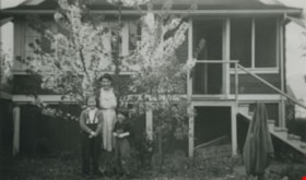
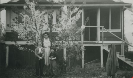
- Photograph of the Allen family mother and daughters in front of a blossoming tree. Left to right: Pat, Marjorie (mother) and Stephanie. This photograph was taken at their home at 3976 McGill Street.
- Repository
- City of Burnaby Archives
- Date
- 1940 (date of original), copied 1992
- Collection/Fonds
- Burnaby Historical Society fonds
- Subseries
- Burnaby Centennial Anthology subseries
- Physical Description
- 1 photograph : b&w ; 7.4 x 12.3 cm print
- Description Level
- Item
- Record No.
- 315-251
- Access Restriction
- No restrictions
- Reproduction Restriction
- No known restrictions
- Accession Number
- BHS1994-04
- Scope and Content
- Photograph of the Allen family mother and daughters in front of a blossoming tree. Left to right: Pat, Marjorie (mother) and Stephanie. This photograph was taken at their home at 3976 McGill Street.
- Media Type
- Photograph
- Notes
- Title based on contents of photograph
- Geographic Access
- McGill Street
- Street Address
- 3976 McGill Street
- Historic Neighbourhood
- Vancouver Heights (Historic Neighbourhood)
- Planning Study Area
- Burnaby Heights Area
Images
A Woman blowing a dandelion
https://search.heritageburnaby.ca/link/archivedescription58928
- Repository
- City of Burnaby Archives
- Date
- ca.1983
- Collection/Fonds
- Columbian Newspaper collection
- Description Level
- Item
- Physical Description
- 1 photograph : b&w ; 24 x 17.5 cm
- Scope and Content
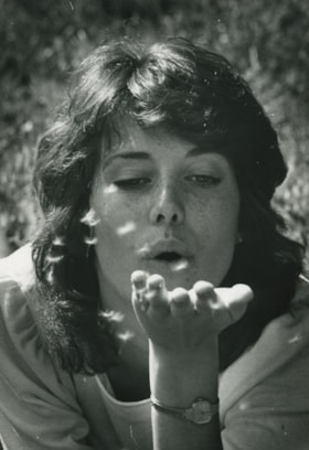
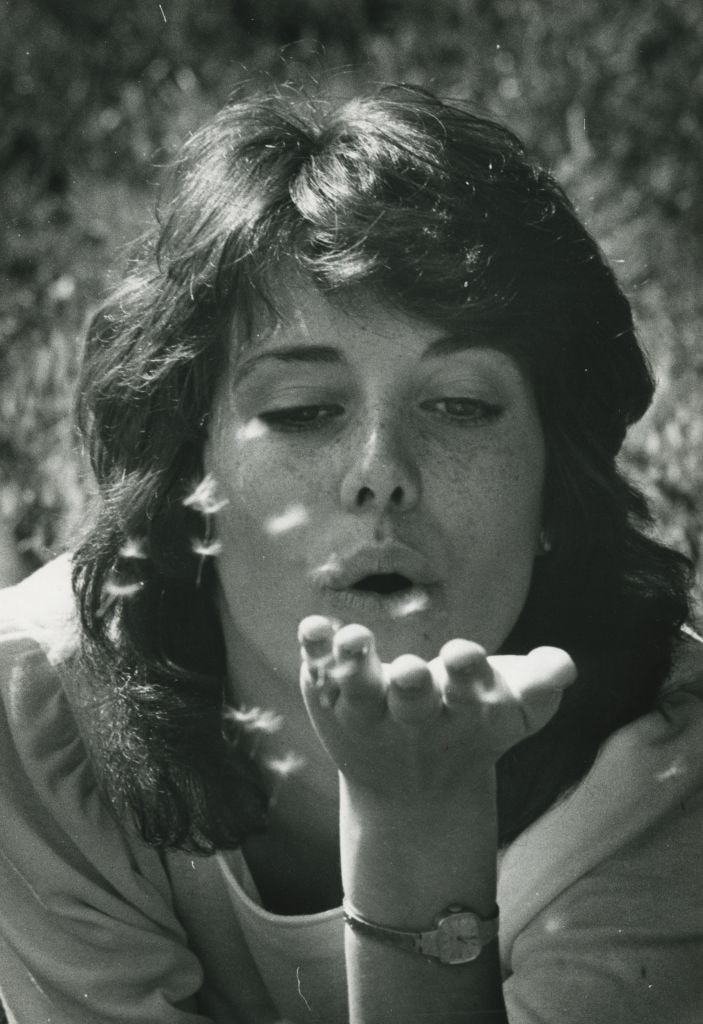
- Photograph of an unidentified woman blowing dandelion seeds from her outstretched hand.
- Repository
- City of Burnaby Archives
- Date
- ca.1983
- Collection/Fonds
- Columbian Newspaper collection
- Physical Description
- 1 photograph : b&w ; 24 x 17.5 cm
- Description Level
- Item
- Record No.
- 480-1378
- Access Restriction
- No restrictions
- Reproduction Restriction
- Reproduce for fair dealing purposes only
- Accession Number
- 2009-01
- Scope and Content
- Photograph of an unidentified woman blowing dandelion seeds from her outstretched hand.
- Subjects
- Plants
- Media Type
- Photograph
- Photographer
- Battistoni, Peter
- Notes
- Title based on contents of photograph
- Photographer's stamp on verso
- Note on verso reads: "PMT 100% / page A-2 / Burnaby / Today"
Images

Bea Carpenter
https://search.heritageburnaby.ca/link/archivedescription37535
- Repository
- City of Burnaby Archives
- Date
- April 10, 1947 (date of original), copied 1991
- Collection/Fonds
- Burnaby Historical Society fonds
- Description Level
- Item
- Physical Description
- 1 photograph : b&w ; 3.7 x 3.1 cm print on contact sheet 20.2 x 25.3 cm
- Scope and Content
- Photograph of Bea Carpenter in the driveway of the George Derby Health Centre on opening day. She is in her nurses uniform and carrying flowers.
- Repository
- City of Burnaby Archives
- Date
- April 10, 1947 (date of original), copied 1991
- Collection/Fonds
- Burnaby Historical Society fonds
- Subseries
- Burnaby Image Bank subseries
- Physical Description
- 1 photograph : b&w ; 3.7 x 3.1 cm print on contact sheet 20.2 x 25.3 cm
- Description Level
- Item
- Record No.
- 370-123
- Access Restriction
- No restrictions
- Reproduction Restriction
- No known restrictions
- Accession Number
- BHS1999-03
- Scope and Content
- Photograph of Bea Carpenter in the driveway of the George Derby Health Centre on opening day. She is in her nurses uniform and carrying flowers.
- Media Type
- Photograph
- Notes
- Title based on contents of photograph
- 1 b&w copy negative accompanying
- Geographic Access
- Cumberland Street
- Street Address
- 7550 Cumberland Street
- Historic Neighbourhood
- East Burnaby (Historic Neighbourhood)
- Planning Study Area
- Cariboo-Armstrong Area
Images

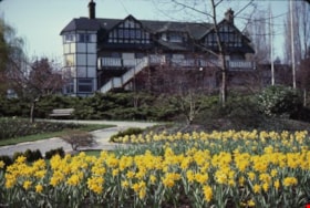
Burnaby Art Gallery daffodil gardens
https://search.heritageburnaby.ca/link/archivedescription36277
- Repository
- City of Burnaby Archives
- Date
- April 1983
- Collection/Fonds
- Burnaby Historical Society fonds
- Description Level
- Item
- Physical Description
- 1 photograph : col. slide ; 2.5 x 3.5 cm
- Scope and Content
- Photograph of the back of the Burnaby Art Gallery and its daffodil gardens.
- Repository
- City of Burnaby Archives
- Date
- April 1983
- Collection/Fonds
- Burnaby Historical Society fonds
- Subseries
- Burnaby Art Gallery subseries
- Physical Description
- 1 photograph : col. slide ; 2.5 x 3.5 cm
- Description Level
- Item
- Record No.
- 242-027
- Access Restriction
- No restrictions
- Reproduction Restriction
- Reproduce for fair dealing purposes only
- Accession Number
- BHS1990-05
- Scope and Content
- Photograph of the back of the Burnaby Art Gallery and its daffodil gardens.
- Names
- Burnaby Art Gallery
- Media Type
- Photograph
- Notes
- Title based on contents of photograph
- Geographic Access
- Deer Lake Avenue
- Street Address
- 6344 Deer Lake Avenue
- Historic Neighbourhood
- Burnaby Lake (Historic Neighbourhood)
- Planning Study Area
- Douglas-Gilpin Area
Images


Burnaby Lake
https://search.heritageburnaby.ca/link/archivedescription91701
- Repository
- City of Burnaby Archives
- Date
- March 1982 - April 1982
- Collection/Fonds
- Doreen Lawson fonds
- Description Level
- File
- Physical Description
- 17 photographs : col. slides ; 35 mm
- Scope and Content
- File consists photographs of Burnaby Lake taken in late winter. The foliage around the lake is primarily brown and wilted with the first new growth of Spring just emerging. Canadian geese swim on the lake in the foreground of several of the photographs, with snow-covered mountains and the Loughee…
- Repository
- City of Burnaby Archives
- Date
- March 1982 - April 1982
- Collection/Fonds
- Doreen Lawson fonds
- Physical Description
- 17 photographs : col. slides ; 35 mm
- Description Level
- File
- Record No.
- 618-019
- Access Restriction
- No restrictions
- Reproduction Restriction
- No restrictions
- Accession Number
- 2015-15
- Scope and Content
- File consists photographs of Burnaby Lake taken in late winter. The foliage around the lake is primarily brown and wilted with the first new growth of Spring just emerging. Canadian geese swim on the lake in the foreground of several of the photographs, with snow-covered mountains and the Lougheed Mall skyline visible in the distance. Also included in the file is one photograph of the forest alongside the Brunette River.
- Media Type
- Photograph
- Photographer
- Lawson, Doreen A.
- Notes
- Transcribed title
- Title transcribed from label on slide sheets photographs originally housed in
- Geographic Access
- Burnaby Lake
- Brunette River
- Historic Neighbourhood
- Burnaby Lake (Historic Neighbourhood)
- Planning Study Area
- Burnaby Lake Area
Images
