Narrow Results By
Subject
- Aerial Photographs 1
- Agriculture - Farms 1
- Agriculture - Fruit and Berries 2
- Animals - Birds 1
- Animals - Dogs 1
- Armament - Munitions 1
- Buildings - Civic - Art Galleries 1
- Buildings - Commercial 3
- Buildings - Commercial - Grocery Stores 2
- Buildings - Commercial - Offices 1
- Buildings - Commercial - Stores 2
- Buildings - Commercial - Train Stations 1
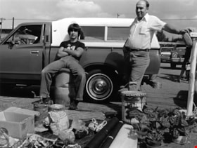
Paint tins and potted plants
https://search.heritageburnaby.ca/link/archivedescription70477
- Repository
- City of Burnaby Archives
- Date
- 1978
- Collection/Fonds
- Bill Jeffries fonds
- Description Level
- Item
- Physical Description
- 1 photograph : b&w ; 18.5 x 23.5 cm
- Scope and Content
- Photograph of paint tins, potted plants and other items arranged on the pavement at the Lougheed Drive-in swap meet in the summer of 1978. Two vendors are nearby; a young man is sitting on a steel drum, leaning against a pick up truck and an older man is standing next to him, leaning on a stand-up …
- Repository
- City of Burnaby Archives
- Date
- 1978
- Collection/Fonds
- Bill Jeffries fonds
- Physical Description
- 1 photograph : b&w ; 18.5 x 23.5 cm
- Description Level
- Item
- Record No.
- 528-126
- Access Restriction
- No restrictions
- Reproduction Restriction
- No restrictions
- Accession Number
- 2011-01
- Scope and Content
- Photograph of paint tins, potted plants and other items arranged on the pavement at the Lougheed Drive-in swap meet in the summer of 1978. Two vendors are nearby; a young man is sitting on a steel drum, leaning against a pick up truck and an older man is standing next to him, leaning on a stand-up lamp.
- Media Type
- Photograph
- Photographer
- Jeffries, Bill
- Notes
- Title based on contents of item
- Geographic Access
- Lougheed Highway
- Historic Neighbourhood
- Broadview (Historic Neighbourhood)
- Planning Study Area
- West Central Valley Area
Images

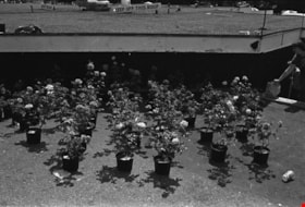
Potted flowering plants
https://search.heritageburnaby.ca/link/archivedescription70271
- Repository
- City of Burnaby Archives
- Date
- 1978
- Collection/Fonds
- Bill Jeffries fonds
- Description Level
- Item
- Physical Description
- 1 photograph : b&w negative ; 35 mm
- Scope and Content
- Photograph of a group of small flowering plants in pots at the Lougheed Drive-in swap meet in the summer of 1978.
- Repository
- City of Burnaby Archives
- Date
- 1978
- Collection/Fonds
- Bill Jeffries fonds
- Physical Description
- 1 photograph : b&w negative ; 35 mm
- Description Level
- Item
- Record No.
- 528-005
- Access Restriction
- No restrictions
- Reproduction Restriction
- No restrictions
- Accession Number
- 2011-01
- Scope and Content
- Photograph of a group of small flowering plants in pots at the Lougheed Drive-in swap meet in the summer of 1978.
- Subjects
- Plants - Flowers
- Media Type
- Photograph
- Photographer
- Jeffries, Bill
- Notes
- Title based on contents of item
- Geographic Access
- Lougheed Highway
- Historic Neighbourhood
- Broadview (Historic Neighbourhood)
- Planning Study Area
- West Central Valley Area
Images

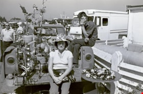
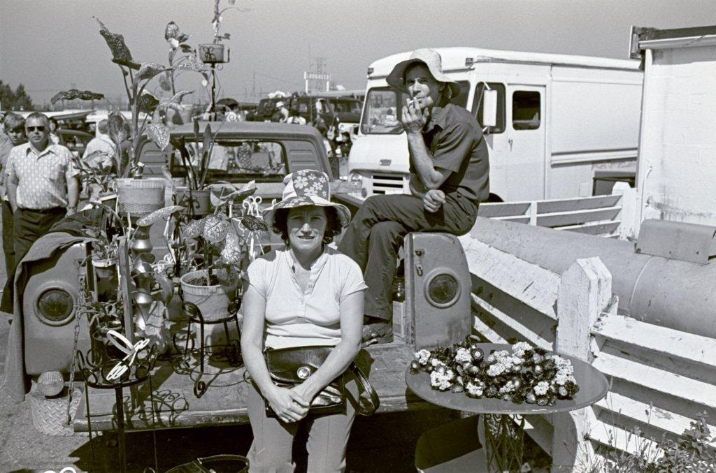
Potted plants and plant stands
https://search.heritageburnaby.ca/link/archivedescription70275
- Repository
- City of Burnaby Archives
- Date
- 1978
- Collection/Fonds
- Bill Jeffries fonds
- Description Level
- Item
- Physical Description
- 1 photograph : b&w negative ; 35 mm
- Scope and Content
- Photograph of two unidentified vendors sitting amongst potted plants and plant stands at the Lougheed Drive-in swap meet in the summer of 1978.
- Repository
- City of Burnaby Archives
- Date
- 1978
- Collection/Fonds
- Bill Jeffries fonds
- Physical Description
- 1 photograph : b&w negative ; 35 mm
- Description Level
- Item
- Record No.
- 528-009
- Access Restriction
- No restrictions
- Reproduction Restriction
- No restrictions
- Accession Number
- 2011-01
- Scope and Content
- Photograph of two unidentified vendors sitting amongst potted plants and plant stands at the Lougheed Drive-in swap meet in the summer of 1978.
- Media Type
- Photograph
- Photographer
- Jeffries, Bill
- Notes
- Title based on contents of item
- 1 b&w print (12.5 x 17.5 cm) accompanying
- Geographic Access
- Lougheed Highway
- Historic Neighbourhood
- Broadview (Historic Neighbourhood)
- Planning Study Area
- West Central Valley Area
Images
Recommendation re Compensation for Damaged Strawberry Plants on 12th Avenue
https://search.heritageburnaby.ca/link/councilreport64571
- Repository
- City of Burnaby Archives
- Report ID
- 55807
- Meeting Date
- 22-Apr-1930
- Format
- Council - Committee Report
- Collection/Fonds
- City Council and Office of the City Clerk fonds
- Repository
- City of Burnaby Archives
- Report ID
- 55807
- Meeting Date
- 22-Apr-1930
- Format
- Council - Committee Report
- Collection/Fonds
- City Council and Office of the City Clerk fonds
Documents
Shell and Standard Oil Plants - Odor Complaints
https://search.heritageburnaby.ca/link/councilreport48585
- Repository
- City of Burnaby Archives
- Report ID
- 48425
- Meeting Date
- 9-Aug-1948
- Format
- Council - Mayor/Councillor/Staff Report
- Collection/Fonds
- City Council and Office of the City Clerk fonds
- Repository
- City of Burnaby Archives
- Report ID
- 48425
- Meeting Date
- 9-Aug-1948
- Format
- Council - Mayor/Councillor/Staff Report
- Collection/Fonds
- City Council and Office of the City Clerk fonds
Documents

Forest Lawn Memorial Park
https://search.heritageburnaby.ca/link/landmark579
- Repository
- Burnaby Heritage Planning
- Description
- Cemetery site.
- Associated Dates
- 1935
- Street View URL
- Google Maps Street View
- Repository
- Burnaby Heritage Planning
- Geographic Access
- Royal Oak Avenue
- Associated Dates
- 1935
- Description
- Cemetery site.
- Heritage Value
- Forest Lawn Memorial Park was founded and designed by Albert F. Arnold, who wanted to design a memorial park “which would be a place of perpetual beauty and which would banish the ‘graveyard’ taint from such places forever.” The 145 acres of Forest Lawn were designed as a garden, which overlooks Vancouver and has a magnificent view of the mountains. Called “God’s Acres,” with white-shelled walks and piped sacred music, the design allowed a natural setting to offer solace to grieve. Bronze memorial plaques were used rather than headstones, which would have marred the garden effect. Arnold acted as a consultant to memorial parks all over Canada and the United States and many of his innovations have become standard practice in North American cemeteries. Equipped with its own greenhouses, the park has more than a million plants of all types. The chapel, which sits on the lower southern slopes, is a sophisticated modernist structure that was designed by renowned local architects McCarter & Nairne.
- Locality
- Burnaby Lake
- Historic Neighbourhood
- Burnaby Lake (Historic Neighbourhood)
- Planning Study Area
- Douglas-Gilpin Area
- Architect
- Albert F. Arnold McCarter & Nairne
- Area
- 449910.00
- Contributing Resource
- Landscape Feature
- Building
- Ownership
- Private
- Street Address
- 3789 Royal Oak Avenue
- Street View URL
- Google Maps Street View
Images

![Forest Lawn Memorial Park buildings and lawns, [1958]. City of Burnaby. Photo ID 067-001. thumbnail](/media/hpo/_Data/_Planning_Images/_Unrestricted/Inventory/BBY-3789-Royal-Oak-Av-1958-Archives%20067-001.jpg)

McColl-Frontenac Oil Company
https://search.heritageburnaby.ca/link/landmark682
- Repository
- Burnaby Heritage Planning
- Associated Dates
- 1945
- Heritage Value
- In 1945, the McColl-Frontenac Oil Company purchased the western section of what used to be the Barnet Mill site from the City of Burnaby. McColl-Frontenac handled the distribution of Texaco gas and built a new plant at the site for this purpose. The company built an improved road access to the plant which later became known as Texaco Drive. Competition from other refineries eventually forced the closure of this plant and in 1985 the area was acquired by the Municipality for the expansion of Barnet Marine Park.
- Historic Neighbourhood
- Barnet (Historic Neighbourhood)
- Planning Study Area
- Burnaby Mountain Area
Images


Ford Motor Company
https://search.heritageburnaby.ca/link/landmark698
- Repository
- Burnaby Heritage Planning
- Geographic Access
- Kingsway
- Associated Dates
- 1938
- Heritage Value
- In 1938, the Ford Motor Company selected Burnaby as its site for a new assembly plant to serve Western Canada. Ford purchased the land which had been owned by the Silver family at Kingsway and Silver Avenue and built its factory using steel from Burnaby's Dominion Bridge Company. During World War II, the plant was used to produce military vehicles. In 1988, the building was demolished and the Station Square development was constructed on the site.
- Historic Neighbourhood
- Central Park (Historic Neighbourhood)
- Planning Study Area
- Maywood Area
- Street Address
- 4600 Kingsway
Images


Jubilee Grove Arch
https://search.heritageburnaby.ca/link/landmark533
- Repository
- Burnaby Heritage Planning
- Description
- The Jubilee Grove Arch sits at the corner of Kingsway and Patterson Avenue. Located within Central Park, the ceremonial arch and its decorative plantings provide a visual anchor to the northeast corner and entry point to the park.
- Associated Dates
- 1939
- Formal Recognition
- Heritage Designation, Community Heritage Register
- Street View URL
- Google Maps Street View
- Repository
- Burnaby Heritage Planning
- Geographic Access
- Imperial Street
- Associated Dates
- 1939
- Formal Recognition
- Heritage Designation, Community Heritage Register
- Enactment Type
- Bylaw No. 9807
- Enactment Date
- 23/11/1992
- Description
- The Jubilee Grove Arch sits at the corner of Kingsway and Patterson Avenue. Located within Central Park, the ceremonial arch and its decorative plantings provide a visual anchor to the northeast corner and entry point to the park.
- Heritage Value
- Jubilee Grove Arch was dedicated as part of the municipality’s celebration of the Jubilee of the coronation of King George V and was dedicated during Burnaby’s annual May Day celebrations in 1935. Much of the construction work was carried out by local citizens under the direction of the Burnaby Engineering Department through a Depression era work relief program that provided a way for local residents to pay their taxes. The garden was also chosen as the site for the ceremonial planting of an oak tree from the Royal Forest at Windsor, in honor of the Coronation of King George VI and Queen Elizabeth in 1937. The original bronze garden dedication plaque and oak tree remain at the site today. The decorative stone arch was erected in 1939 as a symbol of Burnaby's, and the Lower Mainland of British Columbia’s, strong ties to the English monarchy at the time, and the arch’s unveiling during May Day ceremonies shows the social role that such a commemorative feature played both to the local government and people of Burnaby. It was erected just prior to the Royal Visit of 1939, the first time that reigning British monarchs had travelled to Canada. Built of Haddington Island sandstone, the arch itself was reconstructed from a salvaged architectural element of a historic Vancouver landmark. The arch originally framed the entrance door to the Vancouver Club building in Vancouver, built in 1893-94 on West Hastings Street and designed by architect C.O. Wickenden. The building was demolished in 1930, however the arch was stored and rebuilt as the focal point of the Jubilee Grove after being bought by the Municipality of Burnaby. The work was undertaken by Italian-born stone mason Rizieri Stefanini (1879-1954), the owner of Burnaby Monumental Works. The re-use of the arch symbolizes the close tie between Vancouver and Burnaby and the joint evolution of the neighbouring cities.
- Defining Elements
- The Jubilee Grove Arch has character-defining elements that recognize it both as a remnant of a past building and as a new and individual structure. These include its: - axial diagonal placement and prominent corner location marking one of the entries to Central Park - visibility and accessibility as a public monument - hand carved stone blocks of Haddington Island sandstone - decorative twisted-rope motif carved to outline the arch - supporting rusticated sidewalls with planting urns - original bronze dedication plaque - flanking ornamental gardens - Royal Oak tree and plaque
- Historic Neighbourhood
- Central Park (Historic Neighbourhood)
- Planning Study Area
- Maywood Area
- Organization
- City of Burnaby
- Architect
- C.O. Wickenden
- Function
- Primary Current--Park Fixture
- Primary Historic--Park Fixture
- Community
- Burnaby
- Cadastral Identifier
- P.I.D. No. 017-767-172 Legal Description: Block B of Lot 2 Except Firstly: Part on Plan 8669 and Secondly: Part on Plan LMP4689 District Lot 151, Group 1, New Westminster District, Plan 3443
- Boundaries
- The property (Central Park) is a municipally-owned park that lies at the western edge of Burnaby, between 49th Avenue to the south, Kingsway to the north, Boundary Road to the west and Patterson Avenue to the east.
- Area
- 853,403.82
- Contributing Resource
- Structure
- Landscape Feature
- Ownership
- Public (local)
- Documentation
- Heritage Site Files: PC77000 20. City of Burnaby Planning and Building Department, 4949 Canada Way, Burnaby, B.C., V5G 1M2
- Names
- Burnaby Monumental Works
- Street Address
- 3883 Imperial Street
- Street View URL
- Google Maps Street View
Images


Brentwood Neighbourhood
https://search.heritageburnaby.ca/link/landmark780
- Repository
- Burnaby Heritage Planning
- Associated Dates
- 1955-2008
- Heritage Value
- Between 1955 and 2001, the Brentwood Neighbourhood developed into one of Burnaby's four official Town Centres. The Brentwood Town Centre serves the north-west sector of the Municipality, providing facilities such as commercial developments - of which the Brentwood Mall is the most significant. Under Burnaby's Residential Development Framework adopted by Council in 1981, the Town Centre also incorporated a full range of multi-housing types and forms in close relationship with their commercial facilities. In 1996, the City adopted the Brentwood Town Centre Development Plant to solidify the area as a focus of higher-density and higher-intensity residential and commercial opportunities, public transit and supporting leisure facilities.
- Planning Study Area
- Brentwood Area
Images


Broadview Neighbourhood
https://search.heritageburnaby.ca/link/landmark687
- Repository
- Burnaby Heritage Planning
- Associated Dates
- 1925-1954
- Heritage Value
- Development in the Broadview area slowed during World War Two, but after the war, the area became home to a number of industrial sites. The first major plant to be built here was the Dominion Bridge Company which opened in 1930.
- Historic Neighbourhood
- Broadview (Historic Neighbourhood)
- Planning Study Area
- Cascade-Schou Area
Images


Kelly-Douglas Company
https://search.heritageburnaby.ca/link/landmark697
- Repository
- Burnaby Heritage Planning
- Geographic Access
- Kingsway
- Associated Dates
- 1946
- Heritage Value
- The Kelly Douglas Company was founded in 1896 as a wholesale grocery business. It enjoyed rapid success during the Klondike Goldrush of 1898 when it became a primary supplier for prospectors. In 1946, its headquarters moved from Vancouver to Burnaby and a manufacturing plant and warehouse was built on the site.
- Historic Neighbourhood
- Central Park (Historic Neighbourhood)
- Planning Study Area
- Maywood Area
- Street Address
- 4700 Kingsway
Images


Shell Oil Company
https://search.heritageburnaby.ca/link/landmark675
- Repository
- Burnaby Heritage Planning
- Geographic Access
- Kensington Avenue
- Associated Dates
- ca. 1930-1993
- Heritage Value
- After considering several sites in the Greater Vancouver area, the Shell Oil Company chose 70 acres in North Burnaby with frontage of one third of a mile on Burrard Inlet. Shell proposed to build a four-million dollar plant that would employ up to 2000 - providing some relief in the middle of Burnaby's economic crisis of the Depression years. The site became known as the Shellburn Refinery and was in operation until 1993.
- Historic Neighbourhood
- Lochdale (Historic Neighbourhood)
- Planning Study Area
- Westridge Area
Images


Rosalie (Moore) Barrett Residence
https://search.heritageburnaby.ca/link/landmark498
- Repository
- Burnaby Heritage Planning
- Description
- The Rosalie (Moore) Barrett Residence is a one-storey ranch-style bungalow with a cross-gabled roofline, located on Sperling Avenue. It is located within the Deer Lake Park Heritage Precinct, and is adjacent to a related house, the Ethel Moore Residence, built the previous year.
- Associated Dates
- 1942
- Street View URL
- Google Maps Street View
- Repository
- Burnaby Heritage Planning
- Geographic Access
- Sperling Avenue
- Associated Dates
- 1942
- Description
- The Rosalie (Moore) Barrett Residence is a one-storey ranch-style bungalow with a cross-gabled roofline, located on Sperling Avenue. It is located within the Deer Lake Park Heritage Precinct, and is adjacent to a related house, the Ethel Moore Residence, built the previous year.
- Heritage Value
- This house is significant for its connection with first owner, Rosalie Barrett, the daughter of Ethel Hutchings Moore, who lived in the adjacent house at 5145 Sperling Avenue. A spacious modernist bungalow, it was constructed in 1942, and was designed by Rosalie Moore herself. Moore intended to build several houses on this property, but further development was curtailed due to wartime restrictions on domestic construction. The Rosalie (Moore) Barrett Residence is a testament to Deer Lake's continued popularity as a residential neighbourhood in the 1940s. Although Burnaby was serviced by a number of transportation links at the time, the increasing availability of automobiles provided improved access to outlying suburbs. Rising real estate prices in Vancouver and New Westminster attracted residents to this neighbourhood because of its relative affordability, central location and beautiful scenery.
- Defining Elements
- Key elements that define the heritage character of the Rosalie (Moore) Barrett Residence include its: - location within the Deer Lake Park Heritage Precinct - residential form, scale and massing as expressed by its one-storey height, rambling linear plan and cross-gabled roof - wood-frame construction with stucco siding and waney-edged boards in the gable peaks - red brick on the front façade and rough-cut granite at the base of the house - Modernist design as exemplified by the asymmetrical, linear plan with low pitched roof - internal granite chimney - original windows, including wooden-sash casement windows in double and triple-assembly with four-part, horizontal leading - original front door with glass block sidelights - associated landscape features such as granite gateposts, foundation plantings and mature coniferous trees
- Historic Neighbourhood
- Burnaby Lake (Historic Neighbourhood)
- Planning Study Area
- Morley-Buckingham Area
- Function
- Primary Historic--Single Dwelling
- Primary Current--Single Dwelling
- Community
- Deer Lake
- Cadastral Identifier
- P.I.D.006-082-696
- Boundaries
- The Rosalie (Moore) Barrett Residence is comprised of a single residential lot located at 5155 Sperling Avenue, Burnaby.
- Area
- 11291.44
- Contributing Resource
- Building
- Ownership
- Public (local)
- Documentation
- City of Burnaby Planning and Building Department, Heritage Site Files
- Street Address
- 5155 Sperling Avenue
- Street View URL
- Google Maps Street View
Images


![Harry Toy in front of Canada Way Food Market, [197-] thumbnail](/media/hpo/_Data/_BVM_Images/2023/2023_0025_0013_001.jpg?width=280)
Harry Toy in front of Canada Way Food Market
https://search.heritageburnaby.ca/link/museumdescription20352
- Repository
- Burnaby Village Museum
- Date
- [197-]
- Collection/Fonds
- Harry Toy fonds
- Description Level
- Item
- Physical Description
- 1 photograph : col. ; 10 x 15 cm
- Scope and Content
- Photograph of Harry Toy standing next to display of fresh flowers outside in front of the Canada Way Food Market located at 4694 Canada Way, Burnaby.
- Repository
- Burnaby Village Museum
- Collection/Fonds
- Harry Toy fonds
- Series
- Harry Toy photographs series
- Description Level
- Item
- Physical Description
- 1 photograph : col. ; 10 x 15 cm
- Scope and Content
- Photograph of Harry Toy standing next to display of fresh flowers outside in front of the Canada Way Food Market located at 4694 Canada Way, Burnaby.
- Geographic Access
- Canada Way
- Street Address
- 4694 Canada Way
- Accession Code
- BV023.25.13
- Access Restriction
- No restrictions
- Reproduction Restriction
- No known restrictions
- Date
- [197-]
- Media Type
- Photograph
- Related Material
- See also BV023.16.19 - Interview with Harry Toy, Beverley Babey and Christina Toy
- For associated artifacts from Canada Way Food Market see Accession BV023.17
- Scan Resolution
- 600
- Scan Date
- 2023-12-01
- Notes
- Title based on contents of photograph
Images
![Harry Toy in front of Canada Way Food Market, [197-] thumbnail](/media/hpo/_Data/_BVM_Images/2023/2023_0025_0013_001.jpg)
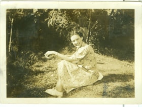
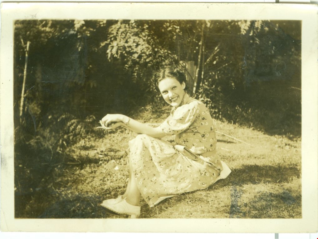
Kay
https://search.heritageburnaby.ca/link/museumdescription2711
- Repository
- Burnaby Village Museum
- Date
- July 25, 1937
- Collection/Fonds
- Hawkshaw family fonds
- Description Level
- Item
- Physical Description
- 1 photograph : sepia ; 5.5 x 8 cm
- Scope and Content
- Photograph of a woman named Kay seated on the grass of Mabel Hawkshaw's home located at 3908 Deer Lake Avenue (R.F. Anderson house - 6504 Deer Lake Avenue). Gardens and trees are visible behind.
- Repository
- Burnaby Village Museum
- Collection/Fonds
- Hawkshaw family fonds
- Description Level
- Item
- Physical Description
- 1 photograph : sepia ; 5.5 x 8 cm
- Scope and Content
- Photograph of a woman named Kay seated on the grass of Mabel Hawkshaw's home located at 3908 Deer Lake Avenue (R.F. Anderson house - 6504 Deer Lake Avenue). Gardens and trees are visible behind.
- Subjects
- Plants - Trees
- Plants - Grasses
- Geographic Access
- Deer Lake Avenue
- Accession Code
- BV996.6.152
- Access Restriction
- No restrictions
- Reproduction Restriction
- No known restrictions
- Date
- July 25, 1937
- Media Type
- Photograph
- Historic Neighbourhood
- Burnaby Lake (Historic Neighbourhood)
- Planning Study Area
- Morley-Buckingham Area
- Scan Resolution
- 600
- Scan Date
- 2/24/2011
- Notes
- Title based on contents of photograph
- Caption for photograph reads: "Kay / '1937' / 'Edition'"
- Photograph is part of photograph album BV996.6.1
Images
![Louise Irwin in cherry tree, [1936] (date of original), copied 2004 thumbnail](/media/hpo/_Data/_BVM_Images/2019/2019_0032_0098_001.jpg?width=280)
Louise Irwin in cherry tree
https://search.heritageburnaby.ca/link/museumdescription15281
- Repository
- Burnaby Village Museum
- Date
- [1936] (date of original), copied 2004
- Collection/Fonds
- In the Shadow by the Sea collection
- Description Level
- Item
- Physical Description
- 1 photograph (tiff) : 300 dpi
- Scope and Content
- Photograph of Louise Irwin standing on a limb of a cherry tree in the yard of the Irwin family home on the site of the Barnet Lumber Mill. The cherry tree is in full bloom with cherry blossoms.
- Repository
- Burnaby Village Museum
- Collection/Fonds
- In the Shadow by the Sea collection
- Description Level
- Item
- Physical Description
- 1 photograph (tiff) : 300 dpi
- Scope and Content
- Photograph of Louise Irwin standing on a limb of a cherry tree in the yard of the Irwin family home on the site of the Barnet Lumber Mill. The cherry tree is in full bloom with cherry blossoms.
- Geographic Access
- Burrard Inlet
- Accession Code
- BV019.32.98
- Access Restriction
- No restrictions
- Reproduction Restriction
- No known restrictions
- Date
- [1936] (date of original), copied 2004
- Media Type
- Photograph
- Historic Neighbourhood
- Barnet (Historic Neighbourhood)
- Planning Study Area
- Burnaby Mountain Area
- Notes
- Title based on contents of photograph
Images
![Louise Irwin in cherry tree, [1936] (date of original), copied 2004 thumbnail](/media/hpo/_Data/_BVM_Images/2019/2019_0032_0098_001.jpg)
![Louise with cherry blossoms, [1937] (date of original), copied 2004 thumbnail](/media/hpo/_Data/_BVM_Images/2019/2019_0032_0095_001.jpg?width=280)
Louise with cherry blossoms
https://search.heritageburnaby.ca/link/museumdescription15278
- Repository
- Burnaby Village Museum
- Date
- [1937] (date of original), copied 2004
- Collection/Fonds
- In the Shadow by the Sea collection
- Description Level
- Item
- Physical Description
- 1 photograph (tiff) : 300 dpi
- Scope and Content
- Photograph of Louise Irwin standing under a cherry tree that is in full bloom with cherry blossoms. The tree is in the yard of the Irwin family home on the site of the Barnet Lumber Mill.
- Repository
- Burnaby Village Museum
- Collection/Fonds
- In the Shadow by the Sea collection
- Description Level
- Item
- Physical Description
- 1 photograph (tiff) : 300 dpi
- Scope and Content
- Photograph of Louise Irwin standing under a cherry tree that is in full bloom with cherry blossoms. The tree is in the yard of the Irwin family home on the site of the Barnet Lumber Mill.
- Geographic Access
- Burrard Inlet
- Accession Code
- BV019.32.95
- Access Restriction
- No restrictions
- Reproduction Restriction
- No known restrictions
- Date
- [1937] (date of original), copied 2004
- Media Type
- Photograph
- Historic Neighbourhood
- Barnet (Historic Neighbourhood)
- Planning Study Area
- Burnaby Mountain Area
- Notes
- Title based on contents of photograph
Images
![Louise with cherry blossoms, [1937] (date of original), copied 2004 thumbnail](/media/hpo/_Data/_BVM_Images/2019/2019_0032_0095_001.jpg)
Progress report
https://search.heritageburnaby.ca/link/museumlibrary7355
- Repository
- Burnaby Village Museum
- Collection
- Reference Collection
- Material Type
- Moving Images
- Call Number
- 388.46 BCH VR
- Contributor
- British Columbia Electric Company
- Place of Publication
- [British Columbia, Canada]
- Publisher
- BC Hydro
- Publication Date
- c1947
- Physical Description
- 1 videodisc (13 min.) : sd., b&w. ; 4 3/4 in.
- Library Subject (LOC)
- Natural gas industry
- Local transit
- Hydroelectric power plants
- Electric railroads
- Electric power-plants
- Transportation
- British Columbia--History
- Subjects
- Transportation
- Geographic Access
- Vancouver
- Notes
- Summary: Promotional film. The BC Electric Railway Company's $50 million post-war expansion and modernization program, to be completed by 1950. Includes: expansion of transit services, including start of the switch from streetcars to trolley buses; water gas plant; explanation of the Bridge River project, with footage of construction (including La Joie Falls storage dam); Lower Mainland power sub-stations. Various Vancouver street scenes, especially Fraser Street and downtown
- Credit note : sponsored/presented by: British Columbia Electric Company; producer: Lew M. Parry; producing agency/company: Trans-Canada Films Ltd.

50-Foot High Stump
https://search.heritageburnaby.ca/link/archivedescription36668
- Repository
- City of Burnaby Archives
- Date
- 1936 (date of original), copied 1992
- Collection/Fonds
- Burnaby Historical Society fonds
- Description Level
- Item
- Physical Description
- 1 photograph : b&w ; 12.5 x 8.5 cm print
- Scope and Content
- Photograph of a stump in Central Park. Typed note at the bottom of the photograph reads, "Hollow stump in Central Park (about centre of park). Fifty feet high. At five feet from ground, fifty feet in circumference as measured by Mr. and Mrs. R.T. Wilson. Central Park, November 1936. / City Archiv…
- Repository
- City of Burnaby Archives
- Date
- 1936 (date of original), copied 1992
- Collection/Fonds
- Burnaby Historical Society fonds
- Subseries
- Burnaby Centennial Anthology subseries
- Physical Description
- 1 photograph : b&w ; 12.5 x 8.5 cm print
- Description Level
- Item
- Record No.
- 315-023
- Access Restriction
- No restrictions
- Reproduction Restriction
- No known restrictions
- Accession Number
- BHS1994-04
- Scope and Content
- Photograph of a stump in Central Park. Typed note at the bottom of the photograph reads, "Hollow stump in Central Park (about centre of park). Fifty feet high. At five feet from ground, fifty feet in circumference as measured by Mr. and Mrs. R.T. Wilson. Central Park, November 1936. / City Archives."
- Media Type
- Photograph
- Notes
- Title based on contents of photograph
- Geographic Access
- Central Park
- Imperial Street
- Street Address
- 3883 Imperial Street
- Historic Neighbourhood
- Central Park (Historic Neighbourhood)
- Planning Study Area
- Maywood Area
Images
