Narrow Results By
Decade
- 2020s 61
- 2010s 67
- 2000s 80
- 1990s 197
- 1980s 170
- 1970s 182
- 1960s 150
- 1950s 199
- 1940s 220
- 1930s 260
- 1920s 212
- 1910s
- 1900s 133
- 1890s 46
- 1880s 15
- 1870s 6
- 1860s 4
- 1850s 2
- 1840s 1
- 1830s
- 1820s 1
- 1810s 1
- 1800s 1
- 1790s 1
- 1780s 1
- 1770s 1
- 1760s 1
- 1750s 1
- 1740s 1
- 1730s 1
- 1720s 1
- 1710s 1
- 1700s 1
- 1690s 1
- 1680s 1
- 1670s 1
- 1660s 1
- 1650s 1
- 1640s 1
- 1630s 1
- 1620s 1
- 1610s 1
- 1600s 1
Subject
- Accidents - Train Accidents 1
- Advertising Medium - Signs and Signboards 1
- Agriculture - Farms 2
- Animals - Dogs 1
- Animals - Fowl 1
- Buildings - Commercial 3
- Buildings - Commercial - Grocery Stores 2
- Buildings - Commercial - Train Stations 2
- Buildings - Industrial 1
- Buildings - Industrial - Factories 1
- Buildings - Industrial - Saw Mills 2
- Buildings - Public - Post Offices 3
Creator
- Alymer, Jane 1
- Anderson, H. Graeme (Henry Graeme), 1882-1925 1
- Arnold, Matthew, 1822-1888 1
- Barclay, Florence L. (Florence Louisa), 1862-1921 1
- Barrowclough, George Alfred 3
- Bateman, Caroline Mary Wettenhall 1
- B.C. Leather and Findings Company 2
- Blackstone, W. E. (William E.), 1841-1935 1
- Brady, Mary J. 1
- British Columbia Fruit Growers' Association 1
- Broadbridge Commercial Photo Company 1
- Buckland, A. R. (Augustus Robert), 1857-1942 1
Person / Organization
- All Saints Anglican Church 1
- Babey, Beverley 1
- Bateman, Edwin W. 1
- Black, George 1
- Brandrith, Martha Dorothy “Dot” Love 1
- British Columbia Mills Timber and Trading Company 2
- Burnaby Central Secondary School 1
- Burnaby City Hall 1
- Byrne, Peter 1
- Canada Way Food Market 1
- Canadian Pacific Railway Company 5
- Chow, Josephine 1
![Subdivision plans in New Westminster District Group 1 – Burnaby
, [1893-1910] thumbnail](/media/hpo/_Data/_BVM_Cartographic_Material/1977/1977_0093_0016a_001.jpg?width=280)
Subdivision plans in New Westminster District Group 1 – Burnaby
https://search.heritageburnaby.ca/link/museumdescription6985
- Repository
- Burnaby Village Museum
- Date
- [1893-1910]
- Collection/Fonds
- Burnaby Village Museum Map collection
- Description Level
- File
- Physical Description
- 4 plans : blueprint ink on paper mounted on 2 sides of cardboard 76 x 102 cm
- Scope and Content
- Item consists of a large board of two New Westminster District Gp 1 - subdivision plans mounted on one side and two New Westminster District Gp 1 - subdivision plans mounted on the other side. Side A: 1. Blueprint "Plan / of Subdivision / of / Lot 6 / Group One / New Westminster District / Scale…
- Repository
- Burnaby Village Museum
- Collection/Fonds
- Burnaby Village Museum Map collection
- Description Level
- File
- Physical Description
- 4 plans : blueprint ink on paper mounted on 2 sides of cardboard 76 x 102 cm
- Material Details
- Scales [between 1:1584 and 1:3960]
- Index number on edge of board reads: "16"
- Scope and Content
- Item consists of a large board of two New Westminster District Gp 1 - subdivision plans mounted on one side and two New Westminster District Gp 1 - subdivision plans mounted on the other side. Side A: 1. Blueprint "Plan / of Subdivision / of / Lot 6 / Group One / New Westminster District / Scale 5 chs = 1 in. / Map No 748" (Geographic location: Burnaby) 2. Blueprint "Plan / of Subdivision / of a Portion / of / Lot 29 / Group One / New Westminster Dist. / Scale 2 chs = 1 in. / Map No." Name identified in Block H is "Reichenbach" (Geographic location: Burnaby) Side B: 1. Blueprint "Plan / of Subdivision / of North 1/2 of Lot 80 / Group One / New Westminster District / Scale 3 chs = 1 in. / Map No 719" Plan is signed by: "Garden, Hermon & Burwell P.L.S. / Vancouver Jan. 23rd, 1893" (Geographic location: Burnaby) 2. Blueprint "Plan / of Subdivision / of Lot 79, Gr.1 / New Westminster Dist. / Scale 4 chas = 1 in. / Map No 536" Plan is signed by "Garden Hermon & Burwell / Provincial Land Surveyors". (Geographic location: Burnaby)
- Creator
- Garden, Hermon and Burwell
- Accession Code
- HV977.93.16
- Access Restriction
- No restrictions
- Reproduction Restriction
- No known restrictions
- Date
- [1893-1910]
- Media Type
- Cartographic Material
- Historic Neighbourhood
- Edmonds (Historic Neighbourhood)
- Burnaby Lake (Historic Neighbourhood)
- Planning Study Area
- Douglas-Gilpin Area
- Edmonds Area
- Cameron Area
- Scan Resolution
- 300
- Scale
- 72
- Notes
- Title based on contents of file
- Scale is measured in chains. (One chain equals 792 inches)
- The term "Lot" can also refer to a "District Lot”
Images
![Subdivision plans in New Westminster District Group 1 – Burnaby
, [1893-1910] thumbnail](/media/hpo/_Data/_BVM_Cartographic_Material/1977/1977_0093_0016a_001.jpg)

![Survey and Subdivision plans in New Westminster District Group 1 – Burnaby
, [1861]-[1910] thumbnail](/media/hpo/_Data/_BVM_Cartographic_Material/1977/1977_0093_0019a_001.jpg?width=280)
Survey and Subdivision plans in New Westminster District Group 1 – Burnaby
https://search.heritageburnaby.ca/link/museumdescription6988
- Repository
- Burnaby Village Museum
- Date
- [1861]-[1910]
- Collection/Fonds
- Burnaby Village Museum Map collection
- Description Level
- File
- Physical Description
- 14 plans : 3 plans : black ink on paper hand col. + 7 plans : black ink on paper + 4 plans : graphite on paper mounted on 2 sides of cardboard 76 x 102 cm
- Scope and Content
- Item consists of a large board of four New Westminster District Gp 1 - subdivision plans mounted on one side and ten New Westminster District Gp 1 - subdivision plans mounted on the other side. Side A: 1. "Plan /of / Lots 166A, 166 and 167 /, Gr.1, N.W.D. / Showing Misconstructed Roads in Gree…
- Repository
- Burnaby Village Museum
- Collection/Fonds
- Burnaby Village Museum Map collection
- Description Level
- File
- Physical Description
- 14 plans : 3 plans : black ink on paper hand col. + 7 plans : black ink on paper + 4 plans : graphite on paper mounted on 2 sides of cardboard 76 x 102 cm
- Material Details
- Scales [between 1:2376 and 1:7920]
- Index number on edge of board reads: "19"
- Scope and Content
- Item consists of a large board of four New Westminster District Gp 1 - subdivision plans mounted on one side and ten New Westminster District Gp 1 - subdivision plans mounted on the other side. Side A: 1. "Plan /of / Lots 166A, 166 and 167 /, Gr.1, N.W.D. / Showing Misconstructed Roads in Green / 5 chs = 1 in.". (plan is drawn in black ink and hand coloured in red, green and orange ink). A section in the centre of the plan is coloured in red ink and identified as "C.S. Richmond" running from the North Arm of Fraser River to Wiggins Road and divided by "New Wiggins Rd. (as gazetted)" (coloured in orange ink) and two"Constructed Road(s)" (coloured in green ink). Plan is initialed by: "RB" [sic] (in blue pencil crayon) 2. Plan of / Subdivision of / Lot 166 / Group One / New Westminster District / Scale 4 chs = 1 in. / Map No 524". Plan is drawn in graphite and signed by "Surrig [sic] Welhams [sic] / P.L.S." Plan is initialed by: "RB" [sic] (in blue pencil crayon) 3. Plan of "Survey / of Highway / For / Burnaby Council / in / Lots 13 _14 / Group One / Scale 4 chs = 1 in." Signed by "Albert J. Hill, P.L.S." Caribou Street and Caribou Road run through the centre of the plan. Plan is stamped: "Albert J. Hill, Civil Engineer / and / Provincial Land Surveyor, / New Westminster, / B.C.". Plan is initialed by: "RB" [sic] (in blue pencil crayon) 4. A Plan of Lots 166A, 166 and 167, Group One, New Westminster District (drawn in graphite). A section in the centre of the plan is identified as "C.S. Richmond" running from the North Arm of Fraser River and divided by "New Wiggins Rd. (as gazetted)" and two "Constructed Road(s)". Plan is initialed by: "RB" [sic] (in blue pencil crayon) Side B: 1. Small plan drawn in black ink (no title) identifying lots north of the "North Arm" of the Fraser River. Lots identified include: Lot 99, Lot 98, Lot 157, Lot 158, Lot 163, Lot 162, Lot 159, Lot 163, Lot 162, Lot 165, Lot 166A, Lot 155B, Lot 155A and Lot 159. "Scale 40 chains to one inch" . Plan is initialed by: "RB" [sic] (in blue pencil crayon) (Geographic location: Burnaby) 2. Small plan drawn in black ink (no title) identifying lots north of the North Arm of the Fraser River as "Lots 155, 155A, 155B, 155C, 162, 163, 164, 165, 166A and 167". Plan is initialed by: "RB" [sic] (in blue pencil crayon) (Geographic location: Burnaby) 3. Small plan drawn in black ink (no title) which identifies "Lot 151 / Reserve/ for / Race Course"; "Reserve / 64 A / L. 152 G.1"; and other Lots: 32, 33, 34, 35, 36, 38, 39. The plan is signed "Surveyor G.Turn [sic] July / 61 / from Vol 40 R.L. notes [sic]" Plan is stamped: "Albert J. Hill, Civil Engineer / and / Provincial Land Surveyor, / New Westminster, / B.C." Plan is initialed by: "RB" [sic] (in blue pencil crayon) (Geographic location: Burnaby) 4. Small plan drawn in black in with faded red colouring on centre lot identified as "Lot 34" running north from "Vancouver Road" . Plan is stamped: "Albert J. Hill, Civil Engineer / and / Provincial Land Surveyor, / New Westminster, / B.C." Plan is initialed by: "RB" [sic] (in blue pencil crayon) (Geographic location: Burnaby) 5. Plan drawn in graphite and identified as "Lot 98, Gr.1," along with the intials "RB" [sic] (both are handwritten in blue crayon pencil on top of plan) The B.C.E.Railway is identified running through the plan along with Jubilee Road and Royal Oak Road. The plan is signed with the name "Wm. Murray" and the Plan is stamped: "Albert J. Hill, Civil Engineer / and / Provincial Land Surveyor, / New Westminster, / B.C.". (Geographic location: Burnaby) 6. Plan drawn in graphite identified as "Port Lot 13, Gr.1" along with the intials "RB" [sic] (both are handwritten in blue crayon pencil on top of plan) Plan is stamped: "Albert J. Hill, Civil Engineer / and / Provincial Land Surveyor, / New Westminster, / B.C.". (Geographic location: Burnaby) 7.Plan drawn in black ink and identified as "Lot 98 G.1" along with the intials "RB" [sic] (both are handwritten in blue crayon pencil on top of plan). A "Road Reservation" is identified running north between "Electric Tramway" and connecting with "Royal Oak Road". Plan is stamped: "Albert J. Hill, Civil Engineer / and / Provincial Land Surveyor, / New Westminster, / B.C." (Geographic location: Burnaby) 8. Plan drawn in black ink and divided into two sections, the upper plan is identified as "Portion / Lots 100 / area / 101, Gr.1" and the lower plan is identified as "Portion L. 3 G. 1" along with the intials "RB" [sic] (these identifiers are handwritten in blue crayon pencil on top of the plan). Portions of Lot 100 and Lot 101 are each divided into 6 sections and the Portion of Lot 3 plan is divided into 24 sections. The plan includes a note in black ink that reads: " Received from Wm Fromme [sic] / from Wm. Trapp / Nov. 28, 1895 / A. J. T...[sic]". (Geographic location: Burnaby) 9. Plan drawn in black ink (no title) identifying soil, buildings and geographic features in southern Burnaby. The plan is bordered by "New Westminster City" (Tenth Avenue and DL 172) to the south east and DL 173 to the south, DL 158 to the west and the B.C.E. Tramway to the north. Plan includes District Lots: 155A, 158, 159, 171, 160, 53 and 95 and identifies soil, marshland and ravines throughout. Plan identifies the following features: a "Team Road" running through Lots 158 and 159 along with "Fair Orchard Soil / Even Surface Throughout / No Ravines", "Gravel and Shingle" (bottom of Lot 158), "North Arm Road" crossing "Byrne Road" and connecting with "Power House Road" which runs north to connect with "Highland Park Station" and the B.C.E. Tramway, "Power Ho" in the northeast corner of DL 160, a "Brook" connected with a "Deep Ravine" running between DL 53, DL 95 and DL 160 along with "Good Soil" and "Fair Orchard Soil" identified nearby in DL 95. Scale is identified as "10 chs = 1 in." Plan is stamped: "Albert J. Hill, Civil Engineer / and / Provincial Land Surveyor, / New Westminster, / B.C." Plan is initialed by: "RB" [sic] (in blue pencil crayon) (Geographic location: Burnaby) 10. Plan drawn in black ink (no title) with Burnaby Lake and Deer Lake at the centre. The plan is bordered by the following District Lots identified as: 117, 118 and 68 to the west, Lots 80, 79 and 85 to the southwest, Lots 11, 13, and 1 (City of New Westminster) to the south east, the North Road boundary to the east and Lots 8, 56, 57, 59, and 136 to the North. The lower right hand corner of the plan has a small inset which reads: "Burnaby Lake" and "Page 19 R.B. Notes". Plan is initialed by: "RB" [sic] (in blue pencil crayon) (Geographic location: Burnaby)
- Creator
- Hill, Albert James
- Accession Code
- HV977.93.19
- Access Restriction
- No restrictions
- Reproduction Restriction
- No known restrictions
- Date
- [1861]-[1910]
- Media Type
- Cartographic Material
- Scan Resolution
- 300
- Scale
- 72
- Notes
- Title based on contents of file
- Scale is measured in chains. (One chain equals 792 inches)
- The term "Lot" can also refer to a "District Lot”
- Some plans are stamped: "Albert J. Hill, Civil Engineer / and / Provincial Land Surveyor, / New Westminster, / B.C." and intialed: "RB" [sic]
Images
![Survey and Subdivision plans in New Westminster District Group 1 – Burnaby
, [1861]-[1910] thumbnail](/media/hpo/_Data/_BVM_Cartographic_Material/1977/1977_0093_0019a_001.jpg)

Survey and Subdivision plans series
https://search.heritageburnaby.ca/link/museumdescription18778
- Repository
- Burnaby Village Museum
- Date
- [1890-1920]
- Collection/Fonds
- Burnaby Village Museum Map collection
- Description Level
- Series
- Physical Description
- over 1000 plans + textual records (34 notebooks)
- Scope and Content
- Series consists of Survey and Subdivision Plans of Burnaby and other geographic regions, including the Greater Vancouver area and New Westminster District, Group 1 and Group 2 along with a series of surveyor's field notebooks [1917-1940]. A significant portion of this series came from the Land Surv…
- Repository
- Burnaby Village Museum
- Collection/Fonds
- Burnaby Village Museum Map collection
- Description Level
- Series
- Physical Description
- over 1000 plans + textual records (34 notebooks)
- Scope and Content
- Series consists of Survey and Subdivision Plans of Burnaby and other geographic regions, including the Greater Vancouver area and New Westminster District, Group 1 and Group 2 along with a series of surveyor's field notebooks [1917-1940]. A significant portion of this series came from the Land Surveyor's office of Geoffrey K. Burnett, first established by Albert J. Hill in [1890].
- Accession Code
- HV976.57
- HV977.93
- BV998.11
- BV004.14
- Date
- [1890-1920]
- Media Type
- Cartographic Material
- Textual Record
- Notes
- Title based on contents of series
Surveyor field book 32
https://search.heritageburnaby.ca/link/museumdescription19633
- Repository
- Burnaby Village Museum
- Date
- 1913-1929, predominant 1913
- Collection/Fonds
- Burnaby Village Museum Map collection
- Description Level
- Item
- Physical Description
- 1 notebook
- Scope and Content
- Item consists of a field notebook with surveyor's field notes created by B.C. Land Surveyor, Walter Wilkie. Field notes include pertinent information, calculations, sketches and observations including geographic areas in Burnaby (D.L.86 and D.L. 136); Surrey (Twp 1, Twp 7); Maple Ridge (Twp 12); La…
- Repository
- Burnaby Village Museum
- Collection/Fonds
- Burnaby Village Museum Map collection
- Description Level
- Item
- Physical Description
- 1 notebook
- Material Details
- Yellow leather hardcover book with inscription on cover "FIELD BOOK";Technical Manufacturing & Supply Co., Vancouver, B.C.
- Annotation in black ink on front cover reads: "32"
- Includes reference tables at front and back of notebook for surveying computations.
- Scope and Content
- Item consists of a field notebook with surveyor's field notes created by B.C. Land Surveyor, Walter Wilkie. Field notes include pertinent information, calculations, sketches and observations including geographic areas in Burnaby (D.L.86 and D.L. 136); Surrey (Twp 1, Twp 7); Maple Ridge (Twp 12); Langley (Twp 10, Twp 11 and Lots 36, 304, 308, 309, 312); Dewdney (D.L. 484 Group 1) and Coquitlam (D.L.366 Group 1). Notebook includes a handwritten index of surveying content, on the last few pages at back of book.
- Creator
- Wilkie, "Walter" Gerald
- Subjects
- Occupations - Land Surveyors
- Accession Code
- HV977.128.1
- Access Restriction
- No restrictions
- Reproduction Restriction
- No known restrictions
- Date
- 1913-1929, predominant 1913
- Media Type
- Textual Record
- Notes
- Title based on contents of item
Sweet songs of many voices
https://search.heritageburnaby.ca/link/museumlibrary2418
- Repository
- Burnaby Village Museum
- Collection
- Special Collection
- Material Type
- Book
- Accession Code
- HV976.251.12
- Call Number
- 821.8 WRI
- Contributor
- Wright, Kate A.
- Place of Publication
- London
- Publisher
- George G. Harrap
- Publication Date
- 1912
- Printer
- Ballantyne
- Physical Description
- 118 p. : col. front. ; 20 cm.
- Inscription
- Front endpaper: "50¢ ------- l " [written in pencil] Half-title page: "H.G. - from J.W. - June '24" [written in black ink] Back endpaper: "Boult's Book Store 813 1/2 Cambie St. Vancouver, B.C." [stamped in black ink]
- Library Subject (LOC)
- English poetry
- American poetry
- Notes
- "compiled by Kate A. Wright (Mrs. Athelstan Mellersh)"
- "compiler of "A garland of organe blossoms"; "Dainty poems of the nineteeth century"; "Sacred poems of the nineteeth century"".
Technical notes, R.F.C.
https://search.heritageburnaby.ca/link/museumlibrary6781
- Repository
- Burnaby Village Museum
- Collection
- Special Collection
- Material Type
- Book
- Accession Code
- BV016.48.2
- Call Number
- 620.1 HAR
- Place of Publication
- London
- Publisher
- Harrison and Sons
- Publication Date
- 1916
- Physical Description
- 1 vol. : ill. ; 20 cm.
- Inscription
- Illegible name handwritten on cover of book. "No. 14 Res. Squadron Orderly Room Royal Flying Corps M. W." [stamped on page opposing front and back pastedown]
- Library Subject (LOC)
- World War, 1914-1918
- World War, 1914-1918--Aerial operations, British
- Great Britain--Royal Flying Corps.
- Great Britain. Royal Flying Corps--Handbooks, manuals, etc.
- Airplanes, Military--Great Britain
- Object History
- Military documents and memorabilia of First World War activities of Russell William Mawhinney. Later career of Mr Mawhinney as a Pharmacist in the Dunbar neighbourhood of Vancouver. Papers and memorabilia relating to Mr Mawhinney as an organizer of the Ex RAF Officers Association.
Torchy and Vee
https://search.heritageburnaby.ca/link/museumlibrary230
- Repository
- Burnaby Village Museum
- Author
- Ford, Sewell, 1868-1946
- Publication Date
- c1918
- Call Number
- 813.5 FOR
- Repository
- Burnaby Village Museum
- Collection
- Special Collection
- Material Type
- Book
- Accession Code
- HV971.136.120
- Call Number
- 813.5 FOR
- Author
- Ford, Sewell, 1868-1946
- Place of Publication
- New York
- Publisher
- Grosset & Dunlap
- Publication Date
- c1918
- Series
- Torchy series
- Physical Description
- 307 p., 19 cm.
- Inscription
- "W25", in black ink inside front cover, crossed out in pencil "J.R. Burton / 1324 - 1st E / Vancouver / B.C.", handwritten in black ink inside front cover "1.25", pencilled at top of front endpaper "J.R. Burton", handwritten in black ink on front endpaper
- Library Subject (LOC)
- World War, 1914-1918--United States--Fiction
- Humorous stories
- Fiction--20th century
The treasure of heaven: a romance of riches
https://search.heritageburnaby.ca/link/museumlibrary107
- Repository
- Burnaby Village Museum
- Author
- Corelli, Marie, 1855-1924
- Publication Date
- 1911
- Call Number
- 823.8 COR
- Repository
- Burnaby Village Museum
- Collection
- Special Collection
- Material Type
- Book
- Accession Code
- HV971.38.9
- Call Number
- 823.8 COR
- Author
- Corelli, Marie, 1855-1924
- Place of Publication
- Toronto
- Publisher
- William Briggs
- Publication Date
- 1911
- Physical Description
- viii, 427 p.
- Inscription
- "W-8i", in black ink on white dope inside front cover, crossed out "Douglas", handwritten in pencil on front endpaper "5 --/ ", in pencil on front endpaper, erased "Chas. West / Vancouver / B.C.", handwritten in grey ink on fly-leaf "C.S.W.", handwritten in purple ink inside back cover
- Library Subject (LOC)
- Fiction--20th century
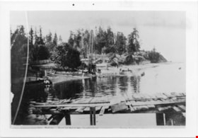
Waterfront Looking west from George Black's
https://search.heritageburnaby.ca/link/museumdescription4775
- Repository
- Burnaby Village Museum
- Date
- 1890-1915
- Collection/Fonds
- Burnaby Village Museum Photograph collection
- Description Level
- Item
- Physical Description
- 1 photograph : b&w ; 8.5 x 12.5 cm ; copy print
- Scope and Content
- Waterfront scene with land on left and water on right. Wooden dock/jetty in foreground. From left to right along the shore there are people wading, a maple tree, a slaughterhouse, a cattle yard, boating bathers, fishing. Trees and houses in background.
- Repository
- Burnaby Village Museum
- Collection/Fonds
- Burnaby Village Museum Photograph collection
- Description Level
- Item
- Physical Description
- 1 photograph : b&w ; 8.5 x 12.5 cm ; copy print
- Material Details
- "Looking west from George Black's. Wading. Maple Tree. Marine ways. Saughterhouse. Cattleyard. Boating Bathers. Fishing. […]" written in black ink on bottom front of photograph. "Columbian files 1971" written on verso in black pen. "996" stamped on back.
- Scope and Content
- Waterfront scene with land on left and water on right. Wooden dock/jetty in foreground. From left to right along the shore there are people wading, a maple tree, a slaughterhouse, a cattle yard, boating bathers, fishing. Trees and houses in background.
- History
- Part of a set of photographs from the Columbian Newspaper, which operated out of New Westminster under this name starting in 1900 until its dissolution in 1988. Photographs found in the collection of the Burnaby Village are dated 1971. George Black (1831-1896). He was born in Aberdeen Scotland, and went to California, then to the Cariboo during the gold rush. He eventually settled on Hastings Street, and was well known in the surroundings of Vancouver.
- Other Title Information
- title based on content and note on front of photograph
- Names
- Black, George
- Accession Code
- BV018.19.1
- Access Restriction
- No restrictions
- Reproduction Restriction
- May be restricted by third party rights
- Date
- 1890-1915
- Media Type
- Photograph
- Scan Resolution
- 600
- Scan Date
- 24-04-2018
Images

Who's who in western Canada : a bibliographical dictionary of notable living men and women of western Canada
https://search.heritageburnaby.ca/link/museumlibrary3393
- Repository
- Burnaby Village Museum
- Collection
- Special Collection
- Material Type
- Book
- Accession Code
- BV993.12.3
- Call Number
- 920 WHO
- Contributor
- Parker, C. W. (Charles Wallace), 1864-1932
- Place of Publication
- Vancouver
- Publisher
- Canadian Press Association
- Publication Date
- 1911
- Physical Description
- 390 p. : ill., ports. ; 20 cm.
- Library Subject (LOC)
- Canada
- Dictionaries
- Biography
- Notes
- "Edited by C.W. Parker" --t.p.
Who's who in western Canada : a bibliographical dictionary of notable living men and women of western Canada, volume 1
https://search.heritageburnaby.ca/link/museumlibrary1820
- Repository
- Burnaby Village Museum
- Collection
- Special Collection
- Material Type
- Book
- Accession Code
- HV983.61.2
- Call Number
- 920 WHO
- Contributor
- Parker, C. W. (Charles Wallace), 1864-1932
- Place of Publication
- Vancouver
- Publisher
- Canadian Press Association
- Publication Date
- 1911
- Physical Description
- 390 p. : ill., ports. ; 20 cm.
- Inscription
- "Presented to Burnaby Historical Society _______ B Brown __M_ Burnaby 1932 to 1959" [handwritten in blue ink on front endpaper]
- Library Subject (LOC)
- Canada
- Dictionaries
- Biography
- Notes
- "Edited by C.W. Parker" --title page
Will power and success
https://search.heritageburnaby.ca/link/museumlibrary1724
- Repository
- Burnaby Village Museum
- Collection
- Special Collection
- Material Type
- Book
- Accession Code
- HV984.21.38
- Call Number
- 150 BUS
- Place of Publication
- St. Louis, Mo.
- Publisher
- D. V. Bush
- Publication Date
- c1916
- Physical Description
- 277 p. ; 20 cm.
- Inscription
- Front endpaper: "Chrissie Youngson" [written in pencil] Front fly leaf: "1922. Chrissie Youngson. 3854 Union St. Vancouver, BC." [written in black ink]
- Notes
- Full author name given as: Bush, David V. (David Van), 1882-
![Woman standing in a garden, [between 1912 and 1925] thumbnail](/media/hpo/_Data/_BVM_Images/1984/1984_0051_0022_001.jpg?width=280)
Woman standing in a garden
https://search.heritageburnaby.ca/link/museumdescription250
- Repository
- Burnaby Village Museum
- Date
- [between 1912 and 1925]
- Collection/Fonds
- Burnaby Village Museum Photograph collection
- Description Level
- Item
- Physical Description
- 1 photograph : sepia ; 11.5 x 7.0 cm
- Scope and Content
- Photograph of a middle aged woman standing in a garden beside a house. She is wearing a long light coloured dress and a hat. The annotation on the back of the photograph identifies her as "Emily." According to the accession register, the location is at Buena Vista, Burnaby, between 1912 and 1925.…
- Repository
- Burnaby Village Museum
- Collection/Fonds
- Burnaby Village Museum Photograph collection
- Description Level
- Item
- Physical Description
- 1 photograph : sepia ; 11.5 x 7.0 cm
- Material Details
- stamped on verso, c. "
- Scope and Content
- Photograph of a middle aged woman standing in a garden beside a house. She is wearing a long light coloured dress and a hat. The annotation on the back of the photograph identifies her as "Emily." According to the accession register, the location is at Buena Vista, Burnaby, between 1912 and 1925. Stamped on the back of the photo: "Better Pictures / NuGloss / Photo Finish / Vancouver Drug Co. Limited" and "141."
- Accession Code
- HV984.51.22
- Access Restriction
- No restrictions
- Reproduction Restriction
- No known restrictions
- Date
- [between 1912 and 1925]
- Media Type
- Photograph
- Historic Neighbourhood
- East Burnaby (Historic Neighbourhood)
- Planning Study Area
- Cariboo-Armstrong Area
- Related Material
- For another photograph of the woman identified as Emily in this accession, see HV984.51.20
- Scan Resolution
- 600
- Scan Date
- 2023-10-10
- Notes
- Title based on contents of photograph
Images
![Woman standing in a garden, [between 1912 and 1925] thumbnail](/media/hpo/_Data/_BVM_Images/1984/1984_0051_0022_001.jpg)
![Woman standing on a field at Buena Vista, [between 1912 and 1925] thumbnail](/media/hpo/_Data/_BVM_Images/1984/1984_0051_0023_001.jpg?width=280)
Woman standing on a field at Buena Vista
https://search.heritageburnaby.ca/link/museumdescription251
- Repository
- Burnaby Village Museum
- Date
- [between 1912 and 1925]
- Collection/Fonds
- Burnaby Village Museum Photograph collection
- Description Level
- Item
- Physical Description
- 1 photograph : sepia ; 11.5 x 7.0 cm
- Scope and Content
- Photograph of a woman standing in a a bed of flowers in a field. There appears to be hills with sparse vegetation behind her. She is wearing an overcoat with a belt around the waist, gloves and a hat. She is holding a purse in her left hand. The accession register identifies the woman as "Emily." …
- Repository
- Burnaby Village Museum
- Collection/Fonds
- Burnaby Village Museum Photograph collection
- Description Level
- Item
- Physical Description
- 1 photograph : sepia ; 11.5 x 7.0 cm
- Scope and Content
- Photograph of a woman standing in a a bed of flowers in a field. There appears to be hills with sparse vegetation behind her. She is wearing an overcoat with a belt around the waist, gloves and a hat. She is holding a purse in her left hand. The accession register identifies the woman as "Emily." According to the accession register, the location is at Buena Vista, Burnaby, from between 1912 and 1925. Stamped on the back of the photograph: "Better Pictures / NuGloss / Photo Finish / Vancouver Drug Co." and "680."
- Subjects
- Plants - Flowers
- Accession Code
- HV984.51.23
- Access Restriction
- No restrictions
- Reproduction Restriction
- No known restrictions
- Date
- [between 1912 and 1925]
- Media Type
- Photograph
- Historic Neighbourhood
- East Burnaby (Historic Neighbourhood)
- Planning Study Area
- Cariboo-Armstrong Area
- Scan Resolution
- 600
- Scan Date
- 2023-10-10
- Notes
- Title based on contents of photograph
Images
![Woman standing on a field at Buena Vista, [between 1912 and 1925] thumbnail](/media/hpo/_Data/_BVM_Images/1984/1984_0051_0023_001.jpg)
The Zodiac birthday book
https://search.heritageburnaby.ca/link/museumlibrary36
- Repository
- Burnaby Village Museum
- Author
- Ruyl, Beatrice Baxter
- Publication Date
- 1910
- Call Number
- 133.5 RUY
- Repository
- Burnaby Village Museum
- Collection
- Special Collection
- Material Type
- Book
- Accession Code
- HV971.12.65
- Call Number
- 133.5 RUY
- Author
- Ruyl, Beatrice Baxter
- Place of Publication
- New York
- Publisher
- Baker & Taylor Co.
- Publication Date
- 1910
- Physical Description
- x, 124 p. : col. ill. ; 21 cm.
- Inscription
- "A Bingham" [handwritten inside front cover]
- "BINGHAM / 4139 Parker St. / Vancouver B. C." [stamped inside front and back covers]
- Library Subject (LOC)
- Astrology