Narrow Results By
Decade
- 2020s 84
- 2010s 213
- 2000s 392
- 1990s 564
- 1980s 550
- 1970s 708
- 1960s 563
- 1950s 588
- 1940s 546
- 1930s 754
- 1920s 704
- 1910s 639
- 1900s 304
- 1890s
- 1880s
- 1870s 14
- 1860s 15
- 1850s 7
- 1840s 3
- 1830s
- 1820s 2
- 1810s 2
- 1800s 2
- 1790s 1
- 1780s 1
- 1770s 1
- 1760s 1
- 1750s 1
- 1740s 1
- 1730s 1
- 1720s 1
- 1710s 1
- 1700s 1
- 1690s 1
- 1680s 1
- 1670s 1
- 1660s 1
- 1650s 1
- 1640s 1
- 1630s 1
- 1620s 1
- 1610s 1
- 1600s 1
Subject
- Agriculture - Farms 1
- Agriculture - Fruit and Berries 3
- Buildings - Commercial - Grocery Stores 1
- Buildings - Commercial - Stores 1
- Buildings - Industrial - Factories 1
- Buildings - Industrial - Powerhouses 1
- Buildings - Industrial - Saw Mills 1
- Buildings - Industrial - Sawmills 1
- Buildings - Residences - Houses 1
- Construction - Road Construction 1
- Documentary Artifacts - Portraits 1
- Education 2
Person / Organization
- Bateman, Edwin W. 1
- Bateman, Marianne May 1
- Bingham, Alfred "Alf" 4
- Black, George 1
- Bradbury, Dr. Bettina 8
- Brandrith, Martha Dorothy “Dot” Love 1
- Burnaby Arts Council 1
- Burnaby Central Secondary School 1
- Burrell, Beverley "Bev" Lewarne 1
- Columbian newspaper 1
- Douglas Road School 1
- Dowad, Kathleen "Kay" 1
Political pamphlets
https://search.heritageburnaby.ca/link/archivedescription64761
- Repository
- City of Burnaby Archives
- Date
- 1899-1957
- Collection/Fonds
- Ernest Winch fonds
- Description Level
- File
- Physical Description
- 1 file of textual records
- Scope and Content
- File consists of political pamphlets and other paper records pertaining to Ernest E. (Ernie) Winch and his eldest son, Harold. Ernest was a long-time Co-operative Commonwealth Federation Member of Parliament and Member of the Legislative Assembly for Burnaby. Harold served as Member of Parliament f…
- Repository
- City of Burnaby Archives
- Date
- 1899-1957
- Collection/Fonds
- Ernest Winch fonds
- Physical Description
- 1 file of textual records
- Description Level
- File
- Record No.
- MSS129-006
- Accession Number
- 2010-06
- Scope and Content
- File consists of political pamphlets and other paper records pertaining to Ernest E. (Ernie) Winch and his eldest son, Harold. Ernest was a long-time Co-operative Commonwealth Federation Member of Parliament and Member of the Legislative Assembly for Burnaby. Harold served as Member of Parliament for Vancouver East and together they set a Guinness world record for the longest father-and-son parliamentary tenure.
- Media Type
- Textual Record
- Notes
- Title based on contents of file
Ronald G. Scobbie collection
https://search.heritageburnaby.ca/link/museumdescription11914
- Repository
- Burnaby Village Museum
- Date
- [1890]-1932
- Collection/Fonds
- Ronald G. Scobbie collection
- Description Level
- Fonds
- Physical Description
- 55 plans + 2 architectural drawings + 1 map + graphic materials + 3 cm of textual records
- Scope and Content
- Fonds consists of survey and subdivision plans, a map and records created by Provincial Land Surveyors Albert J. Hill and Geoffrey K. Burnett and Donald Johnson McGugan and collected by Ronald G. Scobbie. Records include subdivision and survey plans in New Westminster District Group 1 including Dis…
- Repository
- Burnaby Village Museum
- Collection/Fonds
- Ronald G. Scobbie collection
- Description Level
- Fonds
- Physical Description
- 55 plans + 2 architectural drawings + 1 map + graphic materials + 3 cm of textual records
- Scope and Content
- Fonds consists of survey and subdivision plans, a map and records created by Provincial Land Surveyors Albert J. Hill and Geoffrey K. Burnett and Donald Johnson McGugan and collected by Ronald G. Scobbie. Records include subdivision and survey plans in New Westminster District Group 1 including District Lots in Burnaby along with various school sites and church plans; surveying records regarding North Road and a map of the Burnaby Municipality. Fonds is arranged into series: 1) Subdivision and survey plans series 2) School and church plans series 3) Map series
- History
- Ronald G. Scobbie was born in Scotland. After graduating from high school, he worked in the mines of Scotland which led to a career as a land surveyor. Ron immigrated to Canada in 1965 and settled in North Vancouver. In 1967 he became a partner in the surveying company of Hunter, Crockford & Scobbie in New Westminster, eventually owning it under the title Scobbie and Associates between 1980 and 1995. Ron sold the business in 1995 and retired as a BC Land Surveyor in December 2003. Ron was an active member of the B.C. Land Surveyors Association and an avid collector of surveying equipment and maps and plans that document the history of surveying in British Columbia. Upon retirement, Ron donated many historical maps and plans to various repositories located in different geographical regions throughout B.C.
- Scobbie & Associates land surveying company dates back to 1890 when Albert J. Hill first established his practice as a land surveyor in New Westminster. The company went through a series of Surveyors (owners) between 1890 and 1995:
- Albert James Hill (A.J. Hill) [1890] to 1912
- Hill & Burnett 1911 to 1912
- Geoffrey K. Burnett 1912
- Burnett & McGugan 1912 to 1947
- Burnett, McGugan & Hunter 1947 to 1959
- Burnett, Hunter & Douglas 1959 to 1960
- Hunter, Douglas & Crockford 1960 to 1964
- Hunter, Crockford & Associates 1964 to 1965
- Hunter, Crockford & Aplin 1965 to 1967
- Hunter, Crockford & Scobbie 1967 to 1973
- Crockford, Scobbie & Associates 1973-1980
- Scobbie & Associates 1980 to 1995
- Responsibility
- Scobbie, Ronald G.
- Accession Code
- HV984.57
- BV003.83
- Access Restriction
- No restrictions
- Reproduction Restriction
- No known restrictions
- Date
- [1890]-1932
- Related Material
- For other survey and subdivision plans created by land surveyors Albert J. Hill, Geoffery K. Burnett and Donald J. McGugan, see: Burnaby Village Museum Map collection - Survey and Subdivision plans series
- Notes
- Title based on contents of collection
![Seated woman, [188-] thumbnail](/media/hpo/_Data/_BVM_Images/1977/197900500159.jpg?width=280)
Seated woman
https://search.heritageburnaby.ca/link/museumdescription3035
- Repository
- Burnaby Village Museum
- Date
- [188-]
- Collection/Fonds
- Hugh H. Stewart fonds
- Description Level
- Item
- Physical Description
- 1 photograph : b&w tinype ; 9.1 x 6.5 cm
- Scope and Content
- Photograph of an unidentified middle-aged woman with her hair parted in the middle and tied back, wearing a gingham dress and sitting on a chair.
- Repository
- Burnaby Village Museum
- Collection/Fonds
- Hugh H. Stewart fonds
- Description Level
- Item
- Physical Description
- 1 photograph : b&w tinype ; 9.1 x 6.5 cm
- Scope and Content
- Photograph of an unidentified middle-aged woman with her hair parted in the middle and tied back, wearing a gingham dress and sitting on a chair.
- History
- The woman in the photograph is likely Henrietta Stewart, mother of Hugh H. Stewart. She was born in 1860 in France. She married Duncan Hugh Stewart in Pennslyvania and eventually immigrated to Canada, settling in Nanaimo in 1888/1889. The family later moved to Vancouver. She had four children: Hugh Henry, Kate, Kenneth and Duncan.
- Accession Code
- HV979.50.159
- Access Restriction
- No restrictions
- Reproduction Restriction
- No known restrictions
- Date
- [188-]
- Media Type
- Photograph
- Scan Resolution
- 600
- Scan Date
- 2023-09-12
- Notes
- Title based on contents of photograph
Images
![Seated woman, [188-] thumbnail](/media/hpo/_Data/_BVM_Images/1977/197900500159.jpg)
The short rule arithmetic and accountant's referee : illustrated ... : the whole designed as a self-instructor
https://search.heritageburnaby.ca/link/museumlibrary1541
- Repository
- Burnaby Village Museum
- Author
- David, Wm. K. (William King)
- Publication Date
- 1902
- c1889
- c1896
- Call Number
- 511 DAV
- Repository
- Burnaby Village Museum
- Collection
- Special Collection
- Material Type
- Book
- Accession Code
- BV985.3838.2
- Call Number
- 511 DAV
- Author
- David, Wm. K. (William King)
- Place of Publication
- Philadelphia
- Publisher
- Wm. K. David
- Publication Date
- 1902
- c1889
- c1896
- Physical Description
- 88 p. : ill. ; 18 cm.
- Inscription
- "E. L. Keyes" - handwritten in ink on preface page.
- Library Subject (LOC)
- Ready-reckoners
- Business mathematics
- Object History
- Ernest Leslie Keyes was born August 29 1902 to Richard and Isabella Keyes (nee McGregor) in Vancouver. Richard Keyes worked for the CPR. Ernest Keyes later married Beryl Edna Palmer in 1930. Ernest died in 1954 in Victoria. His cousin by marriage was BVM donor Alma Keyes.
Sousa album : a collection of twenty favorite marches and other compositions etc. for piano
https://search.heritageburnaby.ca/link/museumlibrary1073
- Repository
- Burnaby Village Museum
- Edition
- Carl Fischer ed.
- Publication Date
- c1890
- Call Number
- 786.4 SOU
- Repository
- Burnaby Village Museum
- Collection
- Reference Collection
- Material Type
- Book
- Call Number
- 786.4 SOU
- Edition
- Carl Fischer ed.
- Place of Publication
- New York
- Publisher
- Carl Fischer
- Publication Date
- c1890
- Physical Description
- 72 p. of music
- Inscription
- "WESTERN MUSIC (B.C.) LIMITED / Music Exclusively / 570 Seymour Street / Vancouver, B.C." stamped on cover.
- Library Subject (LOC)
- Piano music, Arranged
- Marches
- Notes
- Contents: The march past of the Corcoran Cadets -- The rifle-regiment march -- "Sound off" march -- The crusader march -- The gladiator march -- The high school cadets march -- The loyal legion march -- The march past of the National Fencibles -- Mother Hubbard march -- The occidental march -- Our flirtation march -- The picadore march -- Semper fidelis, march -- The thunderer, march -- Triumph of time, march -- The Washington post march -- La reine de la mer valses -- Nymphalin, reverie -- The coquette, characteristic dance -- The Presidential polonaise.
![Subdivision plans in New Westminster District Group 1 – Burnaby
, [1893-1910] thumbnail](/media/hpo/_Data/_BVM_Cartographic_Material/1977/1977_0093_0016a_001.jpg?width=280)
Subdivision plans in New Westminster District Group 1 – Burnaby
https://search.heritageburnaby.ca/link/museumdescription6985
- Repository
- Burnaby Village Museum
- Date
- [1893-1910]
- Collection/Fonds
- Burnaby Village Museum Map collection
- Description Level
- File
- Physical Description
- 4 plans : blueprint ink on paper mounted on 2 sides of cardboard 76 x 102 cm
- Scope and Content
- Item consists of a large board of two New Westminster District Gp 1 - subdivision plans mounted on one side and two New Westminster District Gp 1 - subdivision plans mounted on the other side. Side A: 1. Blueprint "Plan / of Subdivision / of / Lot 6 / Group One / New Westminster District / Scale…
- Repository
- Burnaby Village Museum
- Collection/Fonds
- Burnaby Village Museum Map collection
- Description Level
- File
- Physical Description
- 4 plans : blueprint ink on paper mounted on 2 sides of cardboard 76 x 102 cm
- Material Details
- Scales [between 1:1584 and 1:3960]
- Index number on edge of board reads: "16"
- Scope and Content
- Item consists of a large board of two New Westminster District Gp 1 - subdivision plans mounted on one side and two New Westminster District Gp 1 - subdivision plans mounted on the other side. Side A: 1. Blueprint "Plan / of Subdivision / of / Lot 6 / Group One / New Westminster District / Scale 5 chs = 1 in. / Map No 748" (Geographic location: Burnaby) 2. Blueprint "Plan / of Subdivision / of a Portion / of / Lot 29 / Group One / New Westminster Dist. / Scale 2 chs = 1 in. / Map No." Name identified in Block H is "Reichenbach" (Geographic location: Burnaby) Side B: 1. Blueprint "Plan / of Subdivision / of North 1/2 of Lot 80 / Group One / New Westminster District / Scale 3 chs = 1 in. / Map No 719" Plan is signed by: "Garden, Hermon & Burwell P.L.S. / Vancouver Jan. 23rd, 1893" (Geographic location: Burnaby) 2. Blueprint "Plan / of Subdivision / of Lot 79, Gr.1 / New Westminster Dist. / Scale 4 chas = 1 in. / Map No 536" Plan is signed by "Garden Hermon & Burwell / Provincial Land Surveyors". (Geographic location: Burnaby)
- Creator
- Garden, Hermon and Burwell
- Accession Code
- HV977.93.16
- Access Restriction
- No restrictions
- Reproduction Restriction
- No known restrictions
- Date
- [1893-1910]
- Media Type
- Cartographic Material
- Historic Neighbourhood
- Edmonds (Historic Neighbourhood)
- Burnaby Lake (Historic Neighbourhood)
- Planning Study Area
- Douglas-Gilpin Area
- Edmonds Area
- Cameron Area
- Scan Resolution
- 300
- Scale
- 72
- Notes
- Title based on contents of file
- Scale is measured in chains. (One chain equals 792 inches)
- The term "Lot" can also refer to a "District Lot”
Images
![Subdivision plans in New Westminster District Group 1 – Burnaby
, [1893-1910] thumbnail](/media/hpo/_Data/_BVM_Cartographic_Material/1977/1977_0093_0016a_001.jpg)

Sunshine : written in the interest of temperence, sunshine and good humor : for the drunkard, the drunkard maker and the drunkard saver
https://search.heritageburnaby.ca/link/museumlibrary3434
- Repository
- Burnaby Village Museum
- Collection
- Special Collection
- Material Type
- Book
- Accession Code
- BV993.53.92
- Call Number
- 178 BEA
- Edition
- 9th ed.
- Place of Publication
- Hamilton, O[hio]
- Publisher
- Albert Dix
- Publication Date
- 1890
- Physical Description
- 319 p., port., 18 cm.
- Inscription
- Front endpaper: "Jan 1907 To Carbailey [?] Marshall I.O.O.G.F. Flower of B.C. No. 72 Vancouver B.C." [written in red pencil]
- Library Subject (LOC)
- Temperence
- Notes
- Author's given name and dates as follows: Beauchamp, Lou J. (Lou Jenks), 1851-1920
![Survey and Subdivision plans in New Westminster District Group 1 – Burnaby
, [1861]-[1910] thumbnail](/media/hpo/_Data/_BVM_Cartographic_Material/1977/1977_0093_0019a_001.jpg?width=280)
Survey and Subdivision plans in New Westminster District Group 1 – Burnaby
https://search.heritageburnaby.ca/link/museumdescription6988
- Repository
- Burnaby Village Museum
- Date
- [1861]-[1910]
- Collection/Fonds
- Burnaby Village Museum Map collection
- Description Level
- File
- Physical Description
- 14 plans : 3 plans : black ink on paper hand col. + 7 plans : black ink on paper + 4 plans : graphite on paper mounted on 2 sides of cardboard 76 x 102 cm
- Scope and Content
- Item consists of a large board of four New Westminster District Gp 1 - subdivision plans mounted on one side and ten New Westminster District Gp 1 - subdivision plans mounted on the other side. Side A: 1. "Plan /of / Lots 166A, 166 and 167 /, Gr.1, N.W.D. / Showing Misconstructed Roads in Gree…
- Repository
- Burnaby Village Museum
- Collection/Fonds
- Burnaby Village Museum Map collection
- Description Level
- File
- Physical Description
- 14 plans : 3 plans : black ink on paper hand col. + 7 plans : black ink on paper + 4 plans : graphite on paper mounted on 2 sides of cardboard 76 x 102 cm
- Material Details
- Scales [between 1:2376 and 1:7920]
- Index number on edge of board reads: "19"
- Scope and Content
- Item consists of a large board of four New Westminster District Gp 1 - subdivision plans mounted on one side and ten New Westminster District Gp 1 - subdivision plans mounted on the other side. Side A: 1. "Plan /of / Lots 166A, 166 and 167 /, Gr.1, N.W.D. / Showing Misconstructed Roads in Green / 5 chs = 1 in.". (plan is drawn in black ink and hand coloured in red, green and orange ink). A section in the centre of the plan is coloured in red ink and identified as "C.S. Richmond" running from the North Arm of Fraser River to Wiggins Road and divided by "New Wiggins Rd. (as gazetted)" (coloured in orange ink) and two"Constructed Road(s)" (coloured in green ink). Plan is initialed by: "RB" [sic] (in blue pencil crayon) 2. Plan of / Subdivision of / Lot 166 / Group One / New Westminster District / Scale 4 chs = 1 in. / Map No 524". Plan is drawn in graphite and signed by "Surrig [sic] Welhams [sic] / P.L.S." Plan is initialed by: "RB" [sic] (in blue pencil crayon) 3. Plan of "Survey / of Highway / For / Burnaby Council / in / Lots 13 _14 / Group One / Scale 4 chs = 1 in." Signed by "Albert J. Hill, P.L.S." Caribou Street and Caribou Road run through the centre of the plan. Plan is stamped: "Albert J. Hill, Civil Engineer / and / Provincial Land Surveyor, / New Westminster, / B.C.". Plan is initialed by: "RB" [sic] (in blue pencil crayon) 4. A Plan of Lots 166A, 166 and 167, Group One, New Westminster District (drawn in graphite). A section in the centre of the plan is identified as "C.S. Richmond" running from the North Arm of Fraser River and divided by "New Wiggins Rd. (as gazetted)" and two "Constructed Road(s)". Plan is initialed by: "RB" [sic] (in blue pencil crayon) Side B: 1. Small plan drawn in black ink (no title) identifying lots north of the "North Arm" of the Fraser River. Lots identified include: Lot 99, Lot 98, Lot 157, Lot 158, Lot 163, Lot 162, Lot 159, Lot 163, Lot 162, Lot 165, Lot 166A, Lot 155B, Lot 155A and Lot 159. "Scale 40 chains to one inch" . Plan is initialed by: "RB" [sic] (in blue pencil crayon) (Geographic location: Burnaby) 2. Small plan drawn in black ink (no title) identifying lots north of the North Arm of the Fraser River as "Lots 155, 155A, 155B, 155C, 162, 163, 164, 165, 166A and 167". Plan is initialed by: "RB" [sic] (in blue pencil crayon) (Geographic location: Burnaby) 3. Small plan drawn in black ink (no title) which identifies "Lot 151 / Reserve/ for / Race Course"; "Reserve / 64 A / L. 152 G.1"; and other Lots: 32, 33, 34, 35, 36, 38, 39. The plan is signed "Surveyor G.Turn [sic] July / 61 / from Vol 40 R.L. notes [sic]" Plan is stamped: "Albert J. Hill, Civil Engineer / and / Provincial Land Surveyor, / New Westminster, / B.C." Plan is initialed by: "RB" [sic] (in blue pencil crayon) (Geographic location: Burnaby) 4. Small plan drawn in black in with faded red colouring on centre lot identified as "Lot 34" running north from "Vancouver Road" . Plan is stamped: "Albert J. Hill, Civil Engineer / and / Provincial Land Surveyor, / New Westminster, / B.C." Plan is initialed by: "RB" [sic] (in blue pencil crayon) (Geographic location: Burnaby) 5. Plan drawn in graphite and identified as "Lot 98, Gr.1," along with the intials "RB" [sic] (both are handwritten in blue crayon pencil on top of plan) The B.C.E.Railway is identified running through the plan along with Jubilee Road and Royal Oak Road. The plan is signed with the name "Wm. Murray" and the Plan is stamped: "Albert J. Hill, Civil Engineer / and / Provincial Land Surveyor, / New Westminster, / B.C.". (Geographic location: Burnaby) 6. Plan drawn in graphite identified as "Port Lot 13, Gr.1" along with the intials "RB" [sic] (both are handwritten in blue crayon pencil on top of plan) Plan is stamped: "Albert J. Hill, Civil Engineer / and / Provincial Land Surveyor, / New Westminster, / B.C.". (Geographic location: Burnaby) 7.Plan drawn in black ink and identified as "Lot 98 G.1" along with the intials "RB" [sic] (both are handwritten in blue crayon pencil on top of plan). A "Road Reservation" is identified running north between "Electric Tramway" and connecting with "Royal Oak Road". Plan is stamped: "Albert J. Hill, Civil Engineer / and / Provincial Land Surveyor, / New Westminster, / B.C." (Geographic location: Burnaby) 8. Plan drawn in black ink and divided into two sections, the upper plan is identified as "Portion / Lots 100 / area / 101, Gr.1" and the lower plan is identified as "Portion L. 3 G. 1" along with the intials "RB" [sic] (these identifiers are handwritten in blue crayon pencil on top of the plan). Portions of Lot 100 and Lot 101 are each divided into 6 sections and the Portion of Lot 3 plan is divided into 24 sections. The plan includes a note in black ink that reads: " Received from Wm Fromme [sic] / from Wm. Trapp / Nov. 28, 1895 / A. J. T...[sic]". (Geographic location: Burnaby) 9. Plan drawn in black ink (no title) identifying soil, buildings and geographic features in southern Burnaby. The plan is bordered by "New Westminster City" (Tenth Avenue and DL 172) to the south east and DL 173 to the south, DL 158 to the west and the B.C.E. Tramway to the north. Plan includes District Lots: 155A, 158, 159, 171, 160, 53 and 95 and identifies soil, marshland and ravines throughout. Plan identifies the following features: a "Team Road" running through Lots 158 and 159 along with "Fair Orchard Soil / Even Surface Throughout / No Ravines", "Gravel and Shingle" (bottom of Lot 158), "North Arm Road" crossing "Byrne Road" and connecting with "Power House Road" which runs north to connect with "Highland Park Station" and the B.C.E. Tramway, "Power Ho" in the northeast corner of DL 160, a "Brook" connected with a "Deep Ravine" running between DL 53, DL 95 and DL 160 along with "Good Soil" and "Fair Orchard Soil" identified nearby in DL 95. Scale is identified as "10 chs = 1 in." Plan is stamped: "Albert J. Hill, Civil Engineer / and / Provincial Land Surveyor, / New Westminster, / B.C." Plan is initialed by: "RB" [sic] (in blue pencil crayon) (Geographic location: Burnaby) 10. Plan drawn in black ink (no title) with Burnaby Lake and Deer Lake at the centre. The plan is bordered by the following District Lots identified as: 117, 118 and 68 to the west, Lots 80, 79 and 85 to the southwest, Lots 11, 13, and 1 (City of New Westminster) to the south east, the North Road boundary to the east and Lots 8, 56, 57, 59, and 136 to the North. The lower right hand corner of the plan has a small inset which reads: "Burnaby Lake" and "Page 19 R.B. Notes". Plan is initialed by: "RB" [sic] (in blue pencil crayon) (Geographic location: Burnaby)
- Creator
- Hill, Albert James
- Accession Code
- HV977.93.19
- Access Restriction
- No restrictions
- Reproduction Restriction
- No known restrictions
- Date
- [1861]-[1910]
- Media Type
- Cartographic Material
- Scan Resolution
- 300
- Scale
- 72
- Notes
- Title based on contents of file
- Scale is measured in chains. (One chain equals 792 inches)
- The term "Lot" can also refer to a "District Lot”
- Some plans are stamped: "Albert J. Hill, Civil Engineer / and / Provincial Land Surveyor, / New Westminster, / B.C." and intialed: "RB" [sic]
Images
![Survey and Subdivision plans in New Westminster District Group 1 – Burnaby
, [1861]-[1910] thumbnail](/media/hpo/_Data/_BVM_Cartographic_Material/1977/1977_0093_0019a_001.jpg)

![Survey and Subdivision plans in New Westminster District Group 1 – Burnaby
, [1892-1908] thumbnail](/media/hpo/_Data/_BVM_Cartographic_Material/1977/1977_0093_0020a_001.jpg?width=280)
Survey and Subdivision plans in New Westminster District Group 1 – Burnaby
https://search.heritageburnaby.ca/link/museumdescription6989
- Repository
- Burnaby Village Museum
- Date
- [1892-1908]
- Collection/Fonds
- Burnaby Village Museum Map collection
- Description Level
- File
- Physical Description
- 12 plans : 6 plans : black ink on paper + 6 plans : graphite on paper mounted on 2 sides of cardboard 76 x 102 cm
- Scope and Content
- Item consists of a large board of six New Westminster District Gp 1 - subdivision plans mounted on one side and three New Westminster District Gp 1 - subdivision plans mounted on the other side. Side A: 1. Plan drawn in graphite with markings "Plan 535" "Scale 3 chs = 1 in." Plan appears to ext…
- Repository
- Burnaby Village Museum
- Collection/Fonds
- Burnaby Village Museum Map collection
- Description Level
- File
- Physical Description
- 12 plans : 6 plans : black ink on paper + 6 plans : graphite on paper mounted on 2 sides of cardboard 76 x 102 cm
- Material Details
- Scales [between 1:240 and 1:7920]
- Index number on edge of board reads: "20"
- Scope and Content
- Item consists of a large board of six New Westminster District Gp 1 - subdivision plans mounted on one side and three New Westminster District Gp 1 - subdivision plans mounted on the other side. Side A: 1. Plan drawn in graphite with markings "Plan 535" "Scale 3 chs = 1 in." Plan appears to extend onto another piece of paper with a title "Lo [sic] 506" ans "Scale 2 chs = 1 in." Plan is stamped: "Albert J. Hill, Civil Engineer / and / Provincial Land Surveyor, / New Westminster, / B.C." (Geographic location: Burnaby) 2. Plan of "Douglas Road" (written at top in blue pencil) and "Plan 642 / Reg. Apr. 8 1892 / ....Lots / 3 & 4 Bl. I...[sic]" (written in graphite). Road runs through Lots 29, 28, 30, 90 and 91. Note in red ink at bottom of plan reads: "Sketch plans as sent to Council / Aug. 28_1893 / ..." Plan is stamped: "Albert J. Hill, Civil Engineer / and / Provincial Land Surveyor, / New Westminster, / B.C." (Geographic location: Burnaby) 3. Plan drawn in graphite identified with markings "L.9 in / L. 88" "Scale 3 chs = 1 in. / Albert J. Hill / B.C.L.S. / 11/3/08" (Geographic location: Burnaby) 4. Plan in black ink identified as "No.2" / Lot 101 & 100 / Gr.1" / Lot 3 Gr. 1" (handwritten in blue pencil) with "Scale : 2 Inches = 1 Mile". Plan is stamped: "Albert J. Hill, Civil Engineer / and / Provincial Land Surveyor, / New Westminster, / B.C." (Geographic location: Burnaby) 5. Plan in black ink identified as "Sub. L. 28 and 29 of / Lot 35, G - 1" (handwritten in blue pencil) "Scale 100' = 1 in." (Geographic location: Burnaby) 6. Plan drawn in graphite with markings "Lot 165 Gr.1" (handwritten in blue pencil) "Scale 10 chs = 1 in. / Albert J. Hill / B.C.L.S." (Geographic location: Burnaby) 7. "Plan / of Subdivision / of / Subdivision of Lot 10 [sic] / of Lot 53 / Group One / New Westminster Dist. / Scale 1 chs = 1 inc." (drawn and written in graphite) Plan is stamped: "Albert J. Hill, Civil Engineer / and / Provincial Land Surveyor, / New Westminster, / B.C." (Geographic location: Burnaby) Side B: 1. "Plan / of Subdivision / of / Lots 10 and 11, / in the Subdivision / of / Lot 156 Gr.1 / New Westminster District / Scale 100' = 1 "" (drawn and written in graphite) (Geographic location: Burnaby) 2. "Plan / of Subdivision / of a Portion / of / Lot 95 / Group One / New Westminster District / Scale 3 chs = 1 in." (drawn in graphite and black ink) Plan is stamped: "Albert J. Hill, Civil Engineer / and / Provincial Land Surveyor, / New Westminster, / B.C." (Geographic location: Burnaby) 3. Plan drawn in graphite and identified as "Lot 98, Gr.1" (handwritten in blue pencil). Plan identifies a "Road Reservation", "Royal Oak Road" and "Electric Tramway" and "Lot 94" to the north of "Lot 98" (Geographic location: Burnaby) 4. Plan drawn in graphite and identified as "Lot 25, Gr.1" (handwritten in blue pencil) Lot 25 is identified as "Love" "Scale 7 chs = 1 in. / Albert J. Hill B.C.L.S." Plan is dated "24/7/07" Plan is stamped: "Albert J. Hill, Civil Engineer / and / Provincial Land Surveyor, / New Westminster, / B.C." (Geographic location: Burnaby) 5. Profile plan in black ink with marking "Douglas Road" and intials "RGS" [sic] (handwritten in blue pencil) "City Boundary / Hastings Road / Scale Hor 200' = 1" / Vert 20' = 1"" Plan is also marked in red pencil and reads: "Please / See other side". Plan is stamped: "Albert J. Hill, Civil Engineer / and / Provincial Land Surveyor, / New Westminster, / B.C." (Geographic location: Burnaby) 6. Plan of "Profile / on Tramway Track / New Vancouver Road / Scales Hor 200 ft = 1 inch / Vert 20 ft = 1 inch" (Geographic location: Burnaby)
- Creator
- Hill, Albert James
- Accession Code
- HV977.93.20
- Access Restriction
- No restrictions
- Reproduction Restriction
- No known restrictions
- Date
- [1892-1908]
- Media Type
- Cartographic Material
- Scan Resolution
- 300
- Scale
- 72
- Notes
- Title based on contents of file
- Scale is measured in chains and feet. (One chain equals 792 inches)
- The term "Lot" can also refer to a "District Lot”
Images
![Survey and Subdivision plans in New Westminster District Group 1 – Burnaby
, [1892-1908] thumbnail](/media/hpo/_Data/_BVM_Cartographic_Material/1977/1977_0093_0020a_001.jpg)

Survey and Subdivision plans series
https://search.heritageburnaby.ca/link/museumdescription18778
- Repository
- Burnaby Village Museum
- Date
- [1890-1920]
- Collection/Fonds
- Burnaby Village Museum Map collection
- Description Level
- Series
- Physical Description
- over 1000 plans + textual records (34 notebooks)
- Scope and Content
- Series consists of Survey and Subdivision Plans of Burnaby and other geographic regions, including the Greater Vancouver area and New Westminster District, Group 1 and Group 2 along with a series of surveyor's field notebooks [1917-1940]. A significant portion of this series came from the Land Surv…
- Repository
- Burnaby Village Museum
- Collection/Fonds
- Burnaby Village Museum Map collection
- Description Level
- Series
- Physical Description
- over 1000 plans + textual records (34 notebooks)
- Scope and Content
- Series consists of Survey and Subdivision Plans of Burnaby and other geographic regions, including the Greater Vancouver area and New Westminster District, Group 1 and Group 2 along with a series of surveyor's field notebooks [1917-1940]. A significant portion of this series came from the Land Surveyor's office of Geoffrey K. Burnett, first established by Albert J. Hill in [1890].
- Accession Code
- HV976.57
- HV977.93
- BV998.11
- BV004.14
- Date
- [1890-1920]
- Media Type
- Cartographic Material
- Textual Record
- Notes
- Title based on contents of series
Typewritten directory excerpts
https://search.heritageburnaby.ca/link/archivedescription98238
- Repository
- City of Burnaby Archives
- Date
- 1879-1918 (date of originals), [197-] (date copied)
- Collection/Fonds
- Burnaby Historical Society fonds
- Description Level
- File
- Physical Description
- 1 cm of textual records
- Scope and Content
- File includes typewritten copies of sections from three directories: an 1897-1898 directory headed with New Westminster containing six names and longer list of names for Central Park district; Burnaby residents listed in Henderson's Greater Vancouver Directory 1914 (except North Burnaby residents)…
- Repository
- City of Burnaby Archives
- Date
- 1879-1918 (date of originals), [197-] (date copied)
- Collection/Fonds
- Burnaby Historical Society fonds
- Subseries
- Ephemera subseries
- Physical Description
- 1 cm of textual records
- Description Level
- File
- Record No.
- 64998
- Access Restriction
- No restrictions
- Accession Number
- BHS2007-04
- Scope and Content
- File includes typewritten copies of sections from three directories: an 1897-1898 directory headed with New Westminster containing six names and longer list of names for Central Park district; Burnaby residents listed in Henderson's Greater Vancouver Directory 1914 (except North Burnaby residents); and Burnaby Lake, Capitol Hill, Central Park, East Burnaby, Edmonds, Fraser Arm, Jubilee Station, Lochdale, Lozells, McKay district sections of a 1918 directory.
- Media Type
- Textual Record
- Notes
- Title based on contents of file
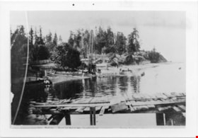
Waterfront Looking west from George Black's
https://search.heritageburnaby.ca/link/museumdescription4775
- Repository
- Burnaby Village Museum
- Date
- 1890-1915
- Collection/Fonds
- Burnaby Village Museum Photograph collection
- Description Level
- Item
- Physical Description
- 1 photograph : b&w ; 8.5 x 12.5 cm ; copy print
- Scope and Content
- Waterfront scene with land on left and water on right. Wooden dock/jetty in foreground. From left to right along the shore there are people wading, a maple tree, a slaughterhouse, a cattle yard, boating bathers, fishing. Trees and houses in background.
- Repository
- Burnaby Village Museum
- Collection/Fonds
- Burnaby Village Museum Photograph collection
- Description Level
- Item
- Physical Description
- 1 photograph : b&w ; 8.5 x 12.5 cm ; copy print
- Material Details
- "Looking west from George Black's. Wading. Maple Tree. Marine ways. Saughterhouse. Cattleyard. Boating Bathers. Fishing. […]" written in black ink on bottom front of photograph. "Columbian files 1971" written on verso in black pen. "996" stamped on back.
- Scope and Content
- Waterfront scene with land on left and water on right. Wooden dock/jetty in foreground. From left to right along the shore there are people wading, a maple tree, a slaughterhouse, a cattle yard, boating bathers, fishing. Trees and houses in background.
- History
- Part of a set of photographs from the Columbian Newspaper, which operated out of New Westminster under this name starting in 1900 until its dissolution in 1988. Photographs found in the collection of the Burnaby Village are dated 1971. George Black (1831-1896). He was born in Aberdeen Scotland, and went to California, then to the Cariboo during the gold rush. He eventually settled on Hastings Street, and was well known in the surroundings of Vancouver.
- Other Title Information
- title based on content and note on front of photograph
- Names
- Black, George
- Accession Code
- BV018.19.1
- Access Restriction
- No restrictions
- Reproduction Restriction
- May be restricted by third party rights
- Date
- 1890-1915
- Media Type
- Photograph
- Scan Resolution
- 600
- Scan Date
- 24-04-2018
Images

William John Beamish genealogical records
https://search.heritageburnaby.ca/link/archivedescription100656
- Repository
- City of Burnaby Archives
- Date
- 1861-1942
- Collection/Fonds
- William Randolph Beamish fonds
- Description Level
- File
- Physical Description
- 0.5 cm. of textual records and 1 large b&w print.
- Scope and Content
- File consists of family history records related to the Beamishes, William Randolph Beamish's adopted family, including a letter certifying the birth and baptism of William John Beamish on December 13, 1860, and June 9, 1861, respectively; a certificate for William John Beamish for the Probationers'…
- Repository
- City of Burnaby Archives
- Date
- 1861-1942
- Collection/Fonds
- William Randolph Beamish fonds
- Physical Description
- 0.5 cm. of textual records and 1 large b&w print.
- Description Level
- File
- Record No.
- 66674
- Access Restriction
- No restrictions
- Accession Number
- 2023-03
- Scope and Content
- File consists of family history records related to the Beamishes, William Randolph Beamish's adopted family, including a letter certifying the birth and baptism of William John Beamish on December 13, 1860, and June 9, 1861, respectively; a certificate for William John Beamish for the Probationers' Course of Study of the Methodist Church of Canada; sermon notes written by W.J. Beamish, as well as "his life as he wrote it”; a financial statement of Newington Circuit; his ordination picture; and obituaries for W.J. Beamish.
- History
- William John Beamish was born in Prescott, Ontario, on December 30, 1860. He was brought up and confirmed in the Anglican Church. While in his teens, he was attending a Methodist Church, became converted, and entered the same church as a candidate for the ministry. His probationary years were spent in the Northern Ontario lumber camps, ministering to the men on Lake Tallon Mission and Nipissing Junction. Mr. Beamish attended McGill College and after ordination at Smiths Falls, Ontario, on June 2, 1896, was appointed to Locksley circuit near Pembroke, then followed pastorates at Hammon, Mille Roches, Moulinette, Morewood, and Berwick. In 1905, while at Morewood, he married Miss Agnes Crabbe, a nurse from Ottawa, formerly Pembroke. Together, they served Wakefield, Quebec, Newington, and Easton's Corners, Ontario. Coming to British Columbia in 1911, they settled first at Kaslo, then Salmon Arm, Vancouver (Dundas), and Maple Ridge. In 1918, Mr. Beamish superannuated and bought a home in Burnaby where he resided until his death on July 26, 1942. During his period of superannuation, Mr. Beamish served for about seven years as minister of East Burnaby Methodist Church and until his death, was a valued member of this congregation, now known as East Burnaby United. He was ever a true friend of the minister and his presence in the congregation was an inspiration. While in good health, he gave his time freely to sick visitation and, in a word, "he went about doing good." Funeral services were conducted by Rev. W.R. Walkinshaw, with Rev. H.E. Horton representing Westminster Presbyterian assisting. Four retired ministers and two laymen acted as pall bearers. His reamins lie in Forest Lawn Memorial Park. He was survived by his wife; one son, Randolph; two daughters, Ethel (Mrs. Paul B. Derrick) and Ilma (Mrs. William Dunn). He was a good husband, a loving father, a dutiful son, and a faithful minister of the Gospel. -- This text was composed and written by Rev. R.W. Walkinshaw and later published in The Observer, the United Church magazine. It has been lightly edited here for grammar and punctuation.
- Media Type
- Textual Record