Narrow Results By
Subject
- Aerial Photographs 8
- Buildings - Residential - Houses 1
- Geographic Features - Rivers 1
- Geographic Features - Roads 1
- Geographic Features - Streams 1
- Government - Provincial Government 6
- Land Clearing 1
- Officials - Alderman and Councillors 5
- Officials - Elected Officials 3
- Officials - Mayors and Reeves 1
- Plants - Trees 1
- Recreational Activities - Boating 1

Government Docks, New Westminster
https://search.heritageburnaby.ca/link/archivedescription39576
- Repository
- City of Burnaby Archives
- Date
- 1910
- Collection/Fonds
- Peers Family and Hill Family fonds
- Description Level
- Item
- Physical Description
- 1 photograph : b&w ; 7.8 x 10.2 cm on page 21.5 x 28 cm (pasted in album)
- Scope and Content
- Photograph of a boat (the "Vite") pulled up to the Government docks at the foot of 8th Street in New Westminster. Queensborough can be seen in the background. The three men in the boat are unidentified.
- Repository
- City of Burnaby Archives
- Date
- 1910
- Collection/Fonds
- Peers Family and Hill Family fonds
- Physical Description
- 1 photograph : b&w ; 7.8 x 10.2 cm on page 21.5 x 28 cm (pasted in album)
- Description Level
- Item
- Record No.
- 477-895
- Access Restriction
- No restrictions
- Reproduction Restriction
- No known restrictions
- Accession Number
- 2007-12
- Scope and Content
- Photograph of a boat (the "Vite") pulled up to the Government docks at the foot of 8th Street in New Westminster. Queensborough can be seen in the background. The three men in the boat are unidentified.
- Subjects
- Recreational Activities - Boating
- Structures - Piers and Wharves
- Geographic Features - Rivers
- Media Type
- Photograph
- Notes
- Title based on contents of photograph
Images


Government Road
https://search.heritageburnaby.ca/link/archivedescription35567
- Repository
- City of Burnaby Archives
- Date
- 1912 (date of original), copied 1986
- Collection/Fonds
- Burnaby Historical Society fonds
- Description Level
- Item
- Physical Description
- 1 photograph : b&w ; 12.7 x 17.8 cm print
- Scope and Content
- Photograph looking east on Government Road from the Haddon family house. One of the men in the photo is Robert Haddon. The other two people are unidentified. Note the loose gravel roadway and the bridge over Eagle Creek.
- Repository
- City of Burnaby Archives
- Date
- 1912 (date of original), copied 1986
- Collection/Fonds
- Burnaby Historical Society fonds
- Subseries
- Pioneer Tales subseries
- Physical Description
- 1 photograph : b&w ; 12.7 x 17.8 cm print
- Description Level
- Item
- Record No.
- 204-425
- Access Restriction
- No restrictions
- Reproduction Restriction
- No known restrictions
- Accession Number
- BHS1988-03
- Scope and Content
- Photograph looking east on Government Road from the Haddon family house. One of the men in the photo is Robert Haddon. The other two people are unidentified. Note the loose gravel roadway and the bridge over Eagle Creek.
- Names
- Haddon, Robert
- Media Type
- Photograph
- Notes
- Title based on contents of photograph
- Geographic Access
- Eagle Creek
- Government Road
- Historic Neighbourhood
- Lozells (Historic Neighbourhood)
- Planning Study Area
- Government Road Area
Images

![Government Road property, [191-] (date of original), copied 1986 thumbnail](/media/hpo/_Data/_Archives_Images/_Unrestricted/204/204-689.jpg?width=280)
Government Road property
https://search.heritageburnaby.ca/link/archivedescription35830
- Repository
- City of Burnaby Archives
- Date
- [191-] (date of original), copied 1986
- Collection/Fonds
- Burnaby Historical Society fonds
- Description Level
- Item
- Physical Description
- 1 photograph : b&w ; 12.7 x 17.8 cm print
- Scope and Content
- Photograph of (left) James Ker (maternal grandfather), (right) Robert Haddon (father), and Gordon Haddon (son), cutting firewood from a large fallen fir with a Wee MacGregor chainsaw on their Hastings Mill property south of the family home on Government Road.
- Repository
- City of Burnaby Archives
- Date
- [191-] (date of original), copied 1986
- Collection/Fonds
- Burnaby Historical Society fonds
- Subseries
- Pioneer Tales subseries
- Physical Description
- 1 photograph : b&w ; 12.7 x 17.8 cm print
- Description Level
- Item
- Record No.
- 204-689
- Access Restriction
- No restrictions
- Reproduction Restriction
- No restrictions
- Accession Number
- BHS1988-03
- Scope and Content
- Photograph of (left) James Ker (maternal grandfather), (right) Robert Haddon (father), and Gordon Haddon (son), cutting firewood from a large fallen fir with a Wee MacGregor chainsaw on their Hastings Mill property south of the family home on Government Road.
- Subjects
- Land Clearing
- Plants - Trees
- Media Type
- Photograph
- Notes
- Title based on contents of photograph
- Geographic Access
- Government Road
- Historic Neighbourhood
- Lozells (Historic Neighbourhood)
- Planning Study Area
- Government Road Area
Images
![Government Road property, [191-] (date of original), copied 1986 thumbnail](/media/hpo/_Data/_Archives_Images/_Unrestricted/204/204-689.jpg)
Emmet J. Cafferky and Robert W. Prittie
https://search.heritageburnaby.ca/link/archivedescription45357
- Repository
- City of Burnaby Archives
- Date
- 1968
- Collection/Fonds
- Columbian Newspaper collection
- Description Level
- Item
- Physical Description
- 1 photograph : b&w ; 21 x 20.5 cm
- Scope and Content
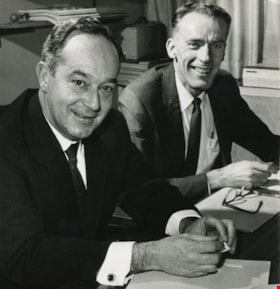
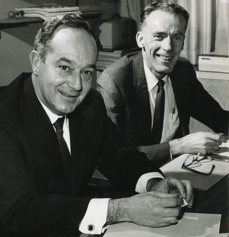
- Photograph of Emmet J. Cafferky and Robert W. Prittie when they were running against each other for Mayor of Burnaby. Emmet J. Cafferky was a Burnaby Alderman from 1957 to 1958, and again from 1963 to 1966. Robert Prittie was a New Democrat Member of Parliament from Burnaby-Richmond from 1962 to 19…
- Repository
- City of Burnaby Archives
- Date
- 1968
- Collection/Fonds
- Columbian Newspaper collection
- Physical Description
- 1 photograph : b&w ; 21 x 20.5 cm
- Description Level
- Item
- Record No.
- 480-252
- Access Restriction
- No restrictions
- Reproduction Restriction
- Reproduce for fair dealing purposes only
- Accession Number
- 2003-02
- Scope and Content
- Photograph of Emmet J. Cafferky and Robert W. Prittie when they were running against each other for Mayor of Burnaby. Emmet J. Cafferky was a Burnaby Alderman from 1957 to 1958, and again from 1963 to 1966. Robert Prittie was a New Democrat Member of Parliament from Burnaby-Richmond from 1962 to 1968 and mayor of Burnaby from 1969 to 1973.
- Subjects
- Government - Provincial Government
- Officials - Mayors and Reeves
- Officials - Alderman and Councillors
- Media Type
- Photograph
- Notes
- Title based on contents of photograph
Images
Eric Greenwood
https://search.heritageburnaby.ca/link/archivedescription45267
- Repository
- City of Burnaby Archives
- Date
- 1962
- Collection/Fonds
- Columbian Newspaper collection
- Description Level
- Item
- Physical Description
- 1 photograph : b&w ; 15 x 9.5 cm
- Scope and Content
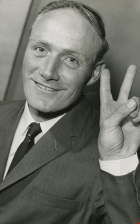
- Photograph of Eric Greenwood smiling, with his hand in the form of a peace sign. He was the Progressive Conservative candidate for the Burnaby-Coquiltam federal riding for the by-election held on October 22, 1962.
- Repository
- City of Burnaby Archives
- Date
- 1962
- Collection/Fonds
- Columbian Newspaper collection
- Physical Description
- 1 photograph : b&w ; 15 x 9.5 cm
- Description Level
- Item
- Record No.
- 480-163
- Access Restriction
- No restrictions
- Reproduction Restriction
- Reproduce for fair dealing purposes only
- Accession Number
- 2003-02
- Scope and Content
- Photograph of Eric Greenwood smiling, with his hand in the form of a peace sign. He was the Progressive Conservative candidate for the Burnaby-Coquiltam federal riding for the by-election held on October 22, 1962.
- Subjects
- Government - Provincial Government
- Media Type
- Photograph
- Notes
- Title based on contents of photograph
Images

Eric Greenwood giving a speech
https://search.heritageburnaby.ca/link/archivedescription45266
- Repository
- City of Burnaby Archives
- Date
- 1962
- Collection/Fonds
- Columbian Newspaper collection
- Description Level
- Item
- Physical Description
- 1 photograph : b&w ; 10 x 4.5 cm
- Scope and Content
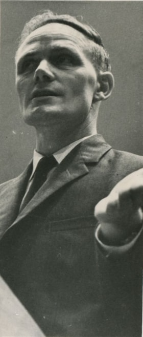
- Photograph of Eric Greenwood giving a speech.He was the Progressive Conservative candidate for the Burnaby-Coquiltam federal riding for the by-election held on October 22, 1962.
- Repository
- City of Burnaby Archives
- Date
- 1962
- Collection/Fonds
- Columbian Newspaper collection
- Physical Description
- 1 photograph : b&w ; 10 x 4.5 cm
- Description Level
- Item
- Record No.
- 480-162
- Access Restriction
- No restrictions
- Reproduction Restriction
- Reproduce for fair dealing purposes only
- Accession Number
- 2003-02
- Scope and Content
- Photograph of Eric Greenwood giving a speech.He was the Progressive Conservative candidate for the Burnaby-Coquiltam federal riding for the by-election held on October 22, 1962.
- Subjects
- Government - Provincial Government
- Media Type
- Photograph
- Notes
- Title based on contents of photograph
Images

![Fred Vulliamy, [1968], published October 21, 1968 thumbnail](/media/hpo/_Data/_Archives_Images/_Unrestricted/480/480-173.jpg?width=280)
Fred Vulliamy
https://search.heritageburnaby.ca/link/archivedescription45277
- Repository
- City of Burnaby Archives
- Date
- [1968], published October 21, 1968
- Collection/Fonds
- Columbian Newspaper collection
- Description Level
- Item
- Physical Description
- 1 photograph : b&w ; 7.5 x 4.5 cm
- Scope and Content
- Photograph of Frederick Justin Vulliamy the New Democratic Party's Member of the Legislative Assembly (MLA) for Burnaby-Willingdon from 1966 until his death in 1968.
- Repository
- City of Burnaby Archives
- Date
- [1968], published October 21, 1968
- Collection/Fonds
- Columbian Newspaper collection
- Physical Description
- 1 photograph : b&w ; 7.5 x 4.5 cm
- Description Level
- Item
- Record No.
- 480-173
- Access Restriction
- No restrictions
- Reproduction Restriction
- Reproduce for fair dealing purposes only
- Accession Number
- 2003-02
- Scope and Content
- Photograph of Frederick Justin Vulliamy the New Democratic Party's Member of the Legislative Assembly (MLA) for Burnaby-Willingdon from 1966 until his death in 1968.
- Subjects
- Government - Provincial Government
- Media Type
- Photograph
- Notes
- Title based on contents of photograph
Images
![Fred Vulliamy, [1968], published October 21, 1968 thumbnail](/media/hpo/_Data/_Archives_Images/_Unrestricted/480/480-173.jpg)
![Fred Vulliamy, [1960] thumbnail](/media/hpo/_Data/_Archives_Images/_Unrestricted/480/480-174.jpg?width=280)
Fred Vulliamy
https://search.heritageburnaby.ca/link/archivedescription45278
- Repository
- City of Burnaby Archives
- Date
- [1960]
- Collection/Fonds
- Columbian Newspaper collection
- Description Level
- Item
- Physical Description
- 1 photograph : b&w ; 5 x 3.5 cm
- Scope and Content
- Photograph of Frederick Justin Vulliamy the New Democratic Party's Member of the Legislative Assembly (MLA) for Burnaby-Willingdon from 1966 until his death in 1968.
- Repository
- City of Burnaby Archives
- Date
- [1960]
- Collection/Fonds
- Columbian Newspaper collection
- Physical Description
- 1 photograph : b&w ; 5 x 3.5 cm
- Description Level
- Item
- Record No.
- 480-174
- Access Restriction
- No restrictions
- Reproduction Restriction
- Reproduce for fair dealing purposes only
- Accession Number
- 2003-02
- Scope and Content
- Photograph of Frederick Justin Vulliamy the New Democratic Party's Member of the Legislative Assembly (MLA) for Burnaby-Willingdon from 1966 until his death in 1968.
- Subjects
- Government - Provincial Government
- Media Type
- Photograph
- Notes
- Title based on contents of photograph
Images
![Fred Vulliamy, [1960] thumbnail](/media/hpo/_Data/_Archives_Images/_Unrestricted/480/480-174.jpg)
![Hugh Walker, [1969] thumbnail](/media/hpo/_Data/_Archives_Images/_Unrestricted/480/480-171.jpg?width=280)
Hugh Walker
https://search.heritageburnaby.ca/link/archivedescription45275
- Repository
- City of Burnaby Archives
- Date
- [1969]
- Collection/Fonds
- Columbian Newspaper collection
- Description Level
- Item
- Physical Description
- 1 photograph : b&w ; 10.5 x 7.5 cm
- Scope and Content
- Photograph of Hugh Walker the Social Credit Candidate for Burnaby-North in the 1969 election.
- Repository
- City of Burnaby Archives
- Date
- [1969]
- Collection/Fonds
- Columbian Newspaper collection
- Physical Description
- 1 photograph : b&w ; 10.5 x 7.5 cm
- Description Level
- Item
- Record No.
- 480-171
- Access Restriction
- No restrictions
- Reproduction Restriction
- Reproduce for fair dealing purposes only
- Accession Number
- 2003-02
- Scope and Content
- Photograph of Hugh Walker the Social Credit Candidate for Burnaby-North in the 1969 election.
- Subjects
- Government - Provincial Government
- Media Type
- Photograph
- Photographer
- Hudson's Bay Company
- Notes
- Title based on contents of photograph
Images
![Hugh Walker, [1969] thumbnail](/media/hpo/_Data/_Archives_Images/_Unrestricted/480/480-171.jpg)

Haddon family home
https://search.heritageburnaby.ca/link/archivedescription35564
- Repository
- City of Burnaby Archives
- Date
- 1919 (date of original), copied 1986
- Collection/Fonds
- Burnaby Historical Society fonds
- Description Level
- Item
- Physical Description
- 1 photograph : b&w ; 12.7 x 17.8 cm print
- Scope and Content
- Photograph of the Haddon family home at 7870 Government Road between Lozells Avenue and Piper Avenue. Three adults and a young child are standing in at the front door.
- Repository
- City of Burnaby Archives
- Date
- 1919 (date of original), copied 1986
- Collection/Fonds
- Burnaby Historical Society fonds
- Subseries
- Pioneer Tales subseries
- Physical Description
- 1 photograph : b&w ; 12.7 x 17.8 cm print
- Description Level
- Item
- Record No.
- 204-422
- Access Restriction
- No restrictions
- Reproduction Restriction
- No known restrictions
- Accession Number
- BHS1988-03
- Scope and Content
- Photograph of the Haddon family home at 7870 Government Road between Lozells Avenue and Piper Avenue. Three adults and a young child are standing in at the front door.
- Subjects
- Buildings - Residential - Houses
- Media Type
- Photograph
- Notes
- Title based on contents of photograph
- Geographic Access
- Government Road
- Street Address
- 7870 Government Road
- Historic Neighbourhood
- Lozells (Historic Neighbourhood)
- Planning Study Area
- Government Road Area
Images

Aerial photograph of Burnaby
https://search.heritageburnaby.ca/link/archivedescription84892
- Repository
- City of Burnaby Archives
- Date
- 1963
- Collection/Fonds
- Allan Amundsen collection
- Description Level
- Item
- Physical Description
- 1 photograph : b&w ; 22.5 x 22.5 cm
- Scope and Content
- Aerial photograph of Burnaby north of Lougheed Highway.
- Repository
- City of Burnaby Archives
- Date
- 1963
- Collection/Fonds
- Allan Amundsen collection
- Physical Description
- 1 photograph : b&w ; 22.5 x 22.5 cm
- Description Level
- Item
- Record No.
- 561-013
- Access Restriction
- In Archives only
- Reproduction Restriction
- No reproduction permitted
- Accession Number
- 2014-08
- Scope and Content
- Aerial photograph of Burnaby north of Lougheed Highway.
- Subjects
- Aerial Photographs
- Media Type
- Photograph
- Photographer
- Province of British Columbia
- Notes
- Title based on contents of photograph
- This photo is indentified as BC5061:118 and connects with B.C. air photograph BC5061:117 to the west and BC5061:119 to the east
- Historic Neighbourhood
- Burnaby Lake (Historic Neighbourhood)
- Lozells (Historic Neighbourhood)
- Planning Study Area
- Parkcrest-Aubrey Area
- Ardingley-Sprott Area
- Sperling-Broadway Area
- Government Road Area
Aerial photograph of Burnaby
https://search.heritageburnaby.ca/link/archivedescription84893
- Repository
- City of Burnaby Archives
- Date
- 1963
- Collection/Fonds
- Allan Amundsen collection
- Description Level
- Item
- Physical Description
- 1 photograph : b&w ; 22.5 x 22.5 cm
- Scope and Content
- Aerial photograph of Burnaby north of Lougheed Highway and west of Sperling Avenue.
- Repository
- City of Burnaby Archives
- Date
- 1963
- Collection/Fonds
- Allan Amundsen collection
- Physical Description
- 1 photograph : b&w ; 22.5 x 22.5 cm
- Description Level
- Item
- Record No.
- 561-014
- Access Restriction
- In Archives only
- Reproduction Restriction
- No reproduction permitted
- Accession Number
- 2014-08
- Scope and Content
- Aerial photograph of Burnaby north of Lougheed Highway and west of Sperling Avenue.
- Subjects
- Aerial Photographs
- Media Type
- Photograph
- Photographer
- Province of British Columbia
- Notes
- Title based on contents of photograph
- This photo is indentified as BC5061:119 and connects with B.C. air photograph BC5061:118 to the west and BC5061:120 to the east
- Geographic Access
- Burnaby Mountain Conservation Area
- Historic Neighbourhood
- Lozells (Historic Neighbourhood)
- Planning Study Area
- Sperling-Broadway Area
- Lake City Area
- Government Road Area
Aerial photograph of Burnaby
https://search.heritageburnaby.ca/link/archivedescription84894
- Repository
- City of Burnaby Archives
- Date
- 1963
- Collection/Fonds
- Allan Amundsen collection
- Description Level
- Item
- Physical Description
- 1 photograph : b&w ; 22.5 x 22.5 cm
- Scope and Content
- Aerial photograph of Burnaby north of Broadway and west of Sperling Avenue.
- Repository
- City of Burnaby Archives
- Date
- 1963
- Collection/Fonds
- Allan Amundsen collection
- Physical Description
- 1 photograph : b&w ; 22.5 x 22.5 cm
- Description Level
- Item
- Record No.
- 561-015
- Access Restriction
- In Archives only
- Reproduction Restriction
- No reproduction permitted
- Accession Number
- 2014-08
- Scope and Content
- Aerial photograph of Burnaby north of Broadway and west of Sperling Avenue.
- Subjects
- Aerial Photographs
- Media Type
- Photograph
- Photographer
- Province of British Columbia
- Notes
- Title based on contents of photograph
- This photo is indentified as BC5061:120 and connects with B.C. air photograph BC5061:119 to the west and BC5061:121 to the east
- Geographic Access
- Burnaby Mountain Conservation Area
- Historic Neighbourhood
- Lozells (Historic Neighbourhood)
- Planning Study Area
- Sperling-Broadway Area
- Lake City Area
- Government Road Area
- Burnaby Mountain Area
Aerial photograph of Burnaby
https://search.heritageburnaby.ca/link/archivedescription84896
- Repository
- City of Burnaby Archives
- Date
- 1963
- Collection/Fonds
- Allan Amundsen collection
- Description Level
- Item
- Physical Description
- 1 photograph : b&w ; 22.5 x 22.5 cm
- Scope and Content
- Aerial photograph of Burnaby north of Broadway and west of Sperling Avenue.
- Repository
- City of Burnaby Archives
- Date
- 1963
- Collection/Fonds
- Allan Amundsen collection
- Physical Description
- 1 photograph : b&w ; 22.5 x 22.5 cm
- Description Level
- Item
- Record No.
- 561-016
- Access Restriction
- In Archives only
- Reproduction Restriction
- No reproduction permitted
- Accession Number
- 2014-08
- Scope and Content
- Aerial photograph of Burnaby north of Broadway and west of Sperling Avenue.
- Subjects
- Aerial Photographs
- Media Type
- Photograph
- Photographer
- Province of British Columbia
- Notes
- Title based on contents of photograph
- This photo is indentified as BC5061:121 and connects with B.C. air photograph BC5061:120 to the west and BC5061:122 to the east
- Geographic Access
- Burnaby Mountain Conservation Area
- Historic Neighbourhood
- Lozells (Historic Neighbourhood)
- Planning Study Area
- Sperling-Broadway Area
- Lake City Area
- Government Road Area
- Burnaby Mountain Area
Aerial photograph of Burnaby
https://search.heritageburnaby.ca/link/archivedescription84911
- Repository
- City of Burnaby Archives
- Date
- 1963
- Collection/Fonds
- Allan Amundsen collection
- Description Level
- Item
- Physical Description
- 1 photograph : b&w ; 22.5 x 22.5 cm
- Scope and Content
- Aerial photograph of Burnaby with Lougheed Highway running west to east through the middle of the photograph and the Trans Canada Highway in the lower left segment.
- Repository
- City of Burnaby Archives
- Date
- 1963
- Collection/Fonds
- Allan Amundsen collection
- Physical Description
- 1 photograph : b&w ; 22.5 x 22.5 cm
- Description Level
- Item
- Record No.
- 561-029
- Access Restriction
- In Archives only
- Reproduction Restriction
- No reproduction permitted
- Accession Number
- 2014-08
- Scope and Content
- Aerial photograph of Burnaby with Lougheed Highway running west to east through the middle of the photograph and the Trans Canada Highway in the lower left segment.
- Subjects
- Aerial Photographs
- Media Type
- Photograph
- Photographer
- Province of British Columbia
- Notes
- Title based on contents of photograph
- This photo is indentified as BC5062:22 and connects with B.C. air photograph BC5062:23 to the west and B.C. air photograph BC5062:21
- Historic Neighbourhood
- Lozells (Historic Neighbourhood)
- Burquitlam (Historic Neighbourhood)
- Planning Study Area
- Lake City Area
- Government Road Area
- Burnaby Lake Area
- Lyndhurst Area
- Cariboo-Armstrong Area
Aerial photograph of Burnaby Lake Area
https://search.heritageburnaby.ca/link/archivedescription84908
- Repository
- City of Burnaby Archives
- Date
- 1963
- Collection/Fonds
- Allan Amundsen collection
- Description Level
- Item
- Physical Description
- 1 photograph : b&w ; 22.5 x 22.5 cm
- Scope and Content
- Aerial photograph of Burnaby with Lougheed Highway in the north west corner, the Trans Canada Highway in the south east corner and Burnaby Lake appearing from the west.
- Repository
- City of Burnaby Archives
- Date
- 1963
- Collection/Fonds
- Allan Amundsen collection
- Physical Description
- 1 photograph : b&w ; 22.5 x 22.5 cm
- Description Level
- Item
- Record No.
- 561-026
- Access Restriction
- In Archives only
- Reproduction Restriction
- No reproduction permitted
- Accession Number
- 2014-08
- Scope and Content
- Aerial photograph of Burnaby with Lougheed Highway in the north west corner, the Trans Canada Highway in the south east corner and Burnaby Lake appearing from the west.
- Subjects
- Aerial Photographs
- Media Type
- Photograph
- Photographer
- Province of British Columbia
- Notes
- Title based on contents of photograph
- This photo is indentified as BC5062:25 and connects with B.C. air photograph BC5062:26 to the west and B.C. air photograph BC5062:24 to the east
- Historic Neighbourhood
- Burnaby Lake (Historic Neighbourhood)
- Lozells (Historic Neighbourhood)
- Planning Study Area
- Douglas-Gilpin Area
- Sperling-Broadway Area
- Government Road Area
- Burnaby Lake Area
Aerial photograph of Burnaby Lake Area
https://search.heritageburnaby.ca/link/archivedescription84909
- Repository
- City of Burnaby Archives
- Date
- 1963
- Collection/Fonds
- Allan Amundsen collection
- Description Level
- Item
- Physical Description
- 1 photograph : b&w ; 22.5 x 22.5 cm
- Scope and Content
- Aerial photograph of Burnaby with Lougheed Highway to the north and Burnaby Lake to the south.
- Repository
- City of Burnaby Archives
- Date
- 1963
- Collection/Fonds
- Allan Amundsen collection
- Physical Description
- 1 photograph : b&w ; 22.5 x 22.5 cm
- Description Level
- Item
- Record No.
- 561-027
- Access Restriction
- In Archives only
- Reproduction Restriction
- No reproduction permitted
- Accession Number
- 2014-08
- Scope and Content
- Aerial photograph of Burnaby with Lougheed Highway to the north and Burnaby Lake to the south.
- Subjects
- Aerial Photographs
- Media Type
- Photograph
- Photographer
- Province of British Columbia
- Notes
- Title based on contents of photograph
- This photo is indentified as BC5062:24 and connects with B.C. air photograph BC5062:25 to the west and B.C. air photograph BC5062:23 to the east
- Historic Neighbourhood
- Burnaby Lake (Historic Neighbourhood)
- Lozells (Historic Neighbourhood)
- Planning Study Area
- Douglas-Gilpin Area
- Sperling-Broadway Area
- Government Road Area
- Burnaby Lake Area
Aerial photograph of Burnaby Lake Area
https://search.heritageburnaby.ca/link/archivedescription84910
- Repository
- City of Burnaby Archives
- Date
- 1963
- Collection/Fonds
- Allan Amundsen collection
- Description Level
- Item
- Physical Description
- 1 photograph : b&w ; 22.5 x 22.5 cm
- Scope and Content
- Aerial photograph of Burnaby with Burnaby Lake to the south and Broadway to the north.
- Repository
- City of Burnaby Archives
- Date
- 1963
- Collection/Fonds
- Allan Amundsen collection
- Physical Description
- 1 photograph : b&w ; 22.5 x 22.5 cm
- Description Level
- Item
- Record No.
- 561-028
- Access Restriction
- In Archives only
- Reproduction Restriction
- No reproduction permitted
- Accession Number
- 2014-08
- Scope and Content
- Aerial photograph of Burnaby with Burnaby Lake to the south and Broadway to the north.
- Subjects
- Aerial Photographs
- Media Type
- Photograph
- Photographer
- Province of British Columbia
- Notes
- Title based on contents of photograph
- This photo is indentified as BC5062:23 and connects with B.C. air photograph BC5062:24 to the west and B.C. air photograph BC5062:22 to the east
- Historic Neighbourhood
- Burnaby Lake (Historic Neighbourhood)
- Lozells (Historic Neighbourhood)
- Planning Study Area
- Lake City Area
- Government Road Area
- Burnaby Lake Area
![J.E. and Hephezebah Ward, [1912] (date of original) thumbnail](/media/hpo/_Data/_Archives_Images/_Unrestricted/251/312-001.jpg?width=280)
J.E. and Hephezebah Ward
https://search.heritageburnaby.ca/link/archivedescription36626
- Repository
- City of Burnaby Archives
- Date
- [1912] (date of original)
- Collection/Fonds
- Burnaby Historical Society fonds
- Description Level
- Item
- Physical Description
- 1 photograph : b&w ; 12.5 x 8.5 cm print
- Scope and Content
- Photograph of Lieutenant Colonel James E. Ward standing next to his wife Hephzebah, who is sitting in a wicker chair outside on the front porch. They look to be on the porch of the Lozells Post Office at the north eastern corner of the Great Northern tracks and Piper Road. In 1908 the couple came t…
- Repository
- City of Burnaby Archives
- Date
- [1912] (date of original)
- Collection/Fonds
- Burnaby Historical Society fonds
- Subseries
- Richard Hardy family subseries
- Physical Description
- 1 photograph : b&w ; 12.5 x 8.5 cm print
- Description Level
- Item
- Record No.
- 312-001
- Access Restriction
- No restrictions
- Reproduction Restriction
- No known restrictions
- Accession Number
- BHS1993-09
- Scope and Content
- Photograph of Lieutenant Colonel James E. Ward standing next to his wife Hephzebah, who is sitting in a wicker chair outside on the front porch. They look to be on the porch of the Lozells Post Office at the north eastern corner of the Great Northern tracks and Piper Road. In 1908 the couple came to Burnaby and opened the post office (naming it Lozells because when they lived in Birmingham England, Hepezebah was a parishioner in the Anglican Parish of Lozells).
- Media Type
- Photograph
- Notes
- Title based on contents of photograph
- Historic Neighbourhood
- Lozells (Historic Neighbourhood)
- Planning Study Area
- Government Road Area
Images
![J.E. and Hephezebah Ward, [1912] (date of original) thumbnail](/media/hpo/_Data/_Archives_Images/_Unrestricted/251/312-001.jpg)
![Richard and Edith Hardy, [1912] (date of original) thumbnail](/media/hpo/_Data/_Archives_Images/_Unrestricted/251/312-003.jpg?width=280)
Richard and Edith Hardy
https://search.heritageburnaby.ca/link/archivedescription36628
- Repository
- City of Burnaby Archives
- Date
- [1912] (date of original)
- Collection/Fonds
- Burnaby Historical Society fonds
- Description Level
- Item
- Physical Description
- 1 photograph : b&w ; 12.5 x 8.5 cm print
- Scope and Content
- Photograph of Richard and Edith Hardy standing inside a fenced yard. Edith has her arms around Richard's shoulders. They are most likely at the Lozells Post Office at the north eastern corner of the Great Northern tracks and Piper Road. In 1908, Col. James Ward and his wife Hepezebah came to Burna…
- Repository
- City of Burnaby Archives
- Date
- [1912] (date of original)
- Collection/Fonds
- Burnaby Historical Society fonds
- Subseries
- Richard Hardy family subseries
- Physical Description
- 1 photograph : b&w ; 12.5 x 8.5 cm print
- Description Level
- Item
- Record No.
- 312-003
- Access Restriction
- No restrictions
- Reproduction Restriction
- No known restrictions
- Accession Number
- BHS1993-09
- Scope and Content
- Photograph of Richard and Edith Hardy standing inside a fenced yard. Edith has her arms around Richard's shoulders. They are most likely at the Lozells Post Office at the north eastern corner of the Great Northern tracks and Piper Road. In 1908, Col. James Ward and his wife Hepezebah came to Burnaby and opened the post office (naming it Lozells because when they lived in Birmingham England, Hepezebah was a parishioner in the Anglican Parish of Lozells).
- Names
- Hardy, Richard
- Hardy, Edith
- Media Type
- Photograph
- Notes
- Title based on contents of photograph
- Historic Neighbourhood
- Lozells (Historic Neighbourhood)
- Planning Study Area
- Government Road Area
Images
![Richard and Edith Hardy, [1912] (date of original) thumbnail](/media/hpo/_Data/_Archives_Images/_Unrestricted/251/312-003.jpg)