Narrow Results By
Subject
- Arts 1
- Buildings - Schools - Universities and Colleges 2
- Ceremonies - Funerals 1
- Elections 1
- Events - Festivals 1
- Occupations - Fire Fighters 1
- Officials - Elected Officials 1
- Officials - Mayors and Reeves 1
- Organizations - Girls' Societies and Clubs 1
- Persons - Students 3
- Recreational Activities - Dancing 1
- Transportation - Electric Railroads 1
Person / Organization
- BC Society of Model Engineers (BCSME) 2
- Bill Copeland Sports Centre 1
- Brandrith Family 1
- British Columbia Electric Railway Company 1
- British Columbia Institute of Technology 3
- Burnaby Fire Department 1
- Burnaby North High School 1
- Cariboo Hill Secondary School 1
- Copeland, William J. 1
- Girl Guides of Canada 1
- Hall, Paulene 1
- Love Family 1
School files - British Columbia Institute of Technology
https://search.heritageburnaby.ca/link/archivedescription66584
- Repository
- City of Burnaby Archives
- Date
- 1988-2005
- Collection/Fonds
- Burnaby Historical Society fonds
- Description Level
- File
- Physical Description
- 1 file of textual records (newsprint)
- Scope and Content
- File consists of newspaper clippings pertaining to the British Columbia Institute of Technology (BCIT).
- Repository
- City of Burnaby Archives
- Date
- 1988-2005
- Collection/Fonds
- Burnaby Historical Society fonds
- Subseries
- School files subseries
- Physical Description
- 1 file of textual records (newsprint)
- Description Level
- File
- Record No.
- 43068
- Accession Number
- BHS2007-04
- Scope and Content
- File consists of newspaper clippings pertaining to the British Columbia Institute of Technology (BCIT).
- Media Type
- Textual Record
- Notes
- Title based on contents of file
Union of British Columbia Municipalities
https://search.heritageburnaby.ca/link/archivedescription755
- Repository
- City of Burnaby Archives
- Date
- 1911-1924
- Collection/Fonds
- City Council and Office of the City Clerk fonds
- Description Level
- File
- Physical Description
- 4 folders textual records
- Scope and Content
- File contains Union of B.C. Municipalities Constitution (1910 Amendment), correspondence regarding UBCM conventions and issues, Burnaby delegates reports, meeting minutes, brochures from UBCM conventions, and booklets of resolutions (1917, 1918).
- Repository
- City of Burnaby Archives
- Date
- 1911-1924
- Collection/Fonds
- City Council and Office of the City Clerk fonds
- Physical Description
- 4 folders textual records
- Description Level
- File
- Record No.
- 2495
- Accession Number
- 2001-02
- Scope and Content
- File contains Union of B.C. Municipalities Constitution (1910 Amendment), correspondence regarding UBCM conventions and issues, Burnaby delegates reports, meeting minutes, brochures from UBCM conventions, and booklets of resolutions (1917, 1918).
- Media Type
- Textual Record

Municipality of Burnaby - Volume XV and Volume XVIII
https://search.heritageburnaby.ca/link/museumdescription8680
- Repository
- Burnaby Village Museum
- Date
- May 1927
- Collection/Fonds
- Burnaby Village Museum Map collection
- Description Level
- File
- Physical Description
- 4 plans on 4 sheets : col. lithographic prints ; 63.5 x 53.5 cm folded to 53 x 31.5 cm
- Scope and Content
- File consists of four pages of plans removed from a bound book containing a series of fire insurance plans of the Municipality of Burnaby. The first two pages are numbered "A" and "B" and are key plans from "GREATER VANCOUVER B.C. / VOLUME XV / Surveyed _ May 1927 / MUNICIPALITY OF / BURNABY", "PLA…
- Repository
- Burnaby Village Museum
- Collection/Fonds
- Burnaby Village Museum Map collection
- Description Level
- File
- Physical Description
- 4 plans on 4 sheets : col. lithographic prints ; 63.5 x 53.5 cm folded to 53 x 31.5 cm
- Material Details
- Scales [1:1200] and [1:6000]
- Scope and Content
- File consists of four pages of plans removed from a bound book containing a series of fire insurance plans of the Municipality of Burnaby. The first two pages are numbered "A" and "B" and are key plans from "GREATER VANCOUVER B.C. / VOLUME XV / Surveyed _ May 1927 / MUNICIPALITY OF / BURNABY", "PLAN DEPT. FIRE BRANCH _ B.C. INSURANCE UNDERWRITERS ASSN.". Key Plan "B" covers plans: 1505; 1506; 1512 to 1516; 1540 to 1544; 1550 to 1557 and District Lots: 129 to 132; 135 to 138; 205 to 208 and 215 to 218. Key Plan "A" covers plans: 1501 to 1504; 1507 to 1511; 1517 to 1525; 1531 to 1539; 1545 to 1550 and District Lots: 116 to 127 and 186 to 189. Plan "1806" is part of "GREATER VANCOUVER B.C. / VOLUME XVIII / Municipality of Burnaby / May, 1927" and covers District Lot 153. Plan "1807" is from "GREATER VANCOUVER B.C. / VOLUME XVIII / Municipality of Burnaby / May, 1927" and covers District Lots: 99,149 and 152.
- Responsibility
- British Columbia Underwriters' Association
- Accession Code
- HV972.111.2
- Access Restriction
- No restrictions
- Reproduction Restriction
- May be restricted by third party rights
- Date
- May 1927
- Media Type
- Cartographic Material
- Historic Neighbourhood
- Vancouver Heights (Historic Neighbourhood)
- Lochdale (Historic Neighbourhood)
- Capitol Hill (Historic Neighbourhood)
- Central Park (Historic Neighbourhood)
- Alta Vista (Historic Neighbourhood)
- Planning Study Area
- Burnaby Heights Area
- Sperling-Broadway Area
- Lochdale Area
- Parkcrest-Aubrey Area
- Westridge Area
- Willingdon Heights Area
- Capitol Hill Area
- Maywood Area
- Marlborough Area
- Scan Resolution
- 400
- Scan Date
- 2021-11-18
- Notes
- Title based on content of plans
- Scales are measured 1 inch = 100 feet and 1 inch = 500 feet
- See also BV987.1.70d for revised versions of plans
Zoomable Images


Municipality of Burnaby - Volume XV and Volume XVIII
https://search.heritageburnaby.ca/link/museumdescription8681
- Repository
- Burnaby Village Museum
- Date
- May 1927
- Collection/Fonds
- Burnaby Village Museum Map collection
- Description Level
- File
- Physical Description
- 4 plans on 4 sheets : col. lithographic prints, ms. annotations in blue ink ; 63.5 x 53.5 cm folded to 53 x 31.5 cm
- Scope and Content
- File consists of four pages of plans removed from a bound book containing a series of fire insurance plans of the Municipality of Burnaby. Plan "1507" and plan "1517" are from "GREATER VANCOUVER B.C. / VOLUME XV / Municipality of Burnaby / May, 1927". Plan "1507" covers District Lot 186 and plan "1…
- Repository
- Burnaby Village Museum
- Collection/Fonds
- Burnaby Village Museum Map collection
- Description Level
- File
- Physical Description
- 4 plans on 4 sheets : col. lithographic prints, ms. annotations in blue ink ; 63.5 x 53.5 cm folded to 53 x 31.5 cm
- Material Details
- Scale [1:600] and [1:1200]
- Scope and Content
- File consists of four pages of plans removed from a bound book containing a series of fire insurance plans of the Municipality of Burnaby. Plan "1507" and plan "1517" are from "GREATER VANCOUVER B.C. / VOLUME XV / Municipality of Burnaby / May, 1927". Plan "1507" covers District Lot 186 and plan "1517" covers District Lot 116. Plan "1804" and plan "1805" are from "GREATER VANCOUVER B.C. / VOLUME XVIII / Municipality of Burnaby / May, 1927". Plans "1804" and "1805" cover District Lot 153.
- Responsibility
- British Columbia Underwriters' Association
- Accession Code
- HV972.111.3
- Access Restriction
- No restrictions
- Reproduction Restriction
- May be restricted by third party rights
- Date
- May 1927
- Media Type
- Cartographic Material
- Historic Neighbourhood
- Central Park (Historic Neighbourhood)
- Vancouver Heights (Historic Neighbourhood)
- Planning Study Area
- Maywood Area
- Willingdon Heights Area
- Scan Resolution
- 400
- Scan Date
- 2021-11-18
- Notes
- Title based on content of plans
- See also BV987.1.70d for revised versions of plans
- Scale is measured 1 inch = 100 feet
Images


![Municipality of Burnaby - Volume XV and Volume XVIII, 1927-[1940] thumbnail](/media/hpo/_Data/_BVM_Artifacts/1972/1972_0111_0004_003.jpg?width=280)
Municipality of Burnaby - Volume XV and Volume XVIII
https://search.heritageburnaby.ca/link/museumdescription8682
- Repository
- Burnaby Village Museum
- Date
- 1927-[1940]
- Collection/Fonds
- Burnaby Village Museum Map collection
- Description Level
- File
- Physical Description
- 4 plans on 4 sheets: col. lithographic prints ; 63.5 x 53.5 cm folded to 53 x 31.5 cm
- Scope and Content
- File consists of four pages of plans removed from a bound book containing a series of fire insurance plans of the Municipality of Burnaby. Plan "1518" and "1519" are from "GREATER VANCOUVER B.C. / VOLUME XV / Municipality of Burnaby / May, 1927". Plan "1518" covers District Lot 116 and Plan "1519"…
- Repository
- Burnaby Village Museum
- Collection/Fonds
- Burnaby Village Museum Map collection
- Description Level
- File
- Physical Description
- 4 plans on 4 sheets: col. lithographic prints ; 63.5 x 53.5 cm folded to 53 x 31.5 cm
- Material Details
- Scale [1:600]
- Scope and Content
- File consists of four pages of plans removed from a bound book containing a series of fire insurance plans of the Municipality of Burnaby. Plan "1518" and "1519" are from "GREATER VANCOUVER B.C. / VOLUME XV / Municipality of Burnaby / May, 1927". Plan "1518" covers District Lot 116 and Plan "1519" covers District Lot 121. Plan "1802" and plan "1803" are from "GREATER VANCOUVER B.C. / VOLUME XVIII / Municipality of Burnaby / May, 1927". Both plans "1802" and "1803" cover District Lot 153.
- Responsibility
- British Columbia Underwriters' Association
- Accession Code
- HV972.111.4
- Access Restriction
- No restrictions
- Reproduction Restriction
- May be restricted by third party rights
- Date
- 1927-[1940]
- Media Type
- Cartographic Material
- Historic Neighbourhood
- Vancouver Heights (Historic Neighbourhood)
- Central Park (Historic Neighbourhood)
- Planning Study Area
- Willingdon Heights Area
- Marlborough Area
- Scan Resolution
- 400
- Scan Date
- 2021-11-18
- Notes
- Title based on content of plans
- See also BV987.1.70d for revised versions of plans
- Scale is measured 1 inch = 50 feet
- Contact Burnaby Village Museum to access plans 1518 and 1519 (these plans have revisions on top - date of revisions is uncertain)
Images
![Municipality of Burnaby - Volume XV and Volume XVIII, 1927-[1940] thumbnail](/media/hpo/_Data/_BVM_Artifacts/1972/1972_0111_0004_003.jpg)


Municipality of Burnaby- Volume XV and Volume XVIII
https://search.heritageburnaby.ca/link/museumdescription8686
- Repository
- Burnaby Village Museum
- Date
- May 1927
- Collection/Fonds
- Burnaby Village Museum Map collection
- Description Level
- File
- Physical Description
- 4 plans on 4 sheets : col. lithographic prints ; 63.5 x 53.5 cm folded to 53 x 31.5 cm
- Scope and Content
- File consists of four pages of plans removed from a bound book containing a series of fire insurance plans of the Municipality of Burnaby. Plan "1520" is part of "GREATER VANCOUVER B.C. / VOLUME XV / Municipality of Burnaby / May 1927" and covers District Lots: 121 and 187. Plann "1521" is part of …
- Repository
- Burnaby Village Museum
- Collection/Fonds
- Burnaby Village Museum Map collection
- Description Level
- File
- Physical Description
- 4 plans on 4 sheets : col. lithographic prints ; 63.5 x 53.5 cm folded to 53 x 31.5 cm
- Material Details
- Scale [1:600] and [1:1200]
- Scope and Content
- File consists of four pages of plans removed from a bound book containing a series of fire insurance plans of the Municipality of Burnaby. Plan "1520" is part of "GREATER VANCOUVER B.C. / VOLUME XV / Municipality of Burnaby / May 1927" and covers District Lots: 121 and 187. Plann "1521" is part of "GREATER VANCOUVER B.C. / VOLUME XV / Municipality of Burnaby / May 1927" and covers District Lots: 121 and 187. Key plan "H" reads: "GREATER VANCOUVER B.C. / VOLUME XVIII / Surveyed _ May 1927 / MUNICIPALITY OF / BURNABY" and covers plans: 1813 to 1822; 1824 to 1832; 1839; 1840; 1853 to 1865 and District Lots: 28; 30; 53; 90 to 93; 95 to 97; 155a; 155b; 155c; 159; 160; 171 to 173. Plan "1801" is part of "GREATER VANCOUVER B.C. / VOLUME XVIII / Municipality of Burnaby / May 1927" and covers District Lot 153.
- Responsibility
- British Columbia Underwriters' Association
- Accession Code
- HV972.111.8
- Access Restriction
- No restrictions
- Reproduction Restriction
- May be restricted by third party rights
- Date
- May 1927
- Media Type
- Cartographic Material
- Historic Neighbourhood
- Fraser Arm (Historic Neighbourhood)
- Vancouver Heights (Historic Neighbourhood)
- East Burnaby (Historic Neighbourhood)
- Edmonds (Historic Neighbourhood)
- Planning Study Area
- Marlborough Area
- Kingsway-Beresford Area
- Windsor Area
- Big Bend Area
- Clinton-Glenwood Area
- Burnaby Heights Area
- Edmonds Area
- Stride Avenue Area
- Scan Resolution
- 400
- Scan Date
- 2021-11-18
- Notes
- Title based on content of plans
- See also BV987.1.70d for revised versions of plans
- Scale is measured 1 inch = 500 feet
Zoomable Images


Municipality of Burnaby - Volume XVI and Volume XVII
https://search.heritageburnaby.ca/link/museumdescription8684
- Repository
- Burnaby Village Museum
- Date
- May 1927
- Collection/Fonds
- Burnaby Village Museum Map collection
- Description Level
- File
- Physical Description
- 4 plans on 4 sheets : col. lithographic prints ; 63.5 x 53.5 cm folded to 53 x 31.5 cm
- Scope and Content
- File consists of four pages of plans removed from a bound book containing a series of fire insurance plans of the Municipality of Burnaby. Page "D" is titled: "GREATER VANCOUVER B.C. / VOLUME XVI / Surveyed _ May 1927 / MUNICIPALITY OF / BURNABY / PLAN DEPT. FIRE BRANCH _ B.C. INSURANCE UNDERWRITE…
- Repository
- Burnaby Village Museum
- Collection/Fonds
- Burnaby Village Museum Map collection
- Description Level
- File
- Physical Description
- 4 plans on 4 sheets : col. lithographic prints ; 63.5 x 53.5 cm folded to 53 x 31.5 cm
- Material Details
- Scale [1:1200] and [1:6000]
- Scope and Content
- File consists of four pages of plans removed from a bound book containing a series of fire insurance plans of the Municipality of Burnaby. Page "D" is titled: "GREATER VANCOUVER B.C. / VOLUME XVI / Surveyed _ May 1927 / MUNICIPALITY OF / BURNABY / PLAN DEPT. FIRE BRANCH _ B.C. INSURANCE UNDERWRITERS ASSN." / KEY PLAN". Plans covered in this "Key Plan" are numbered 1601 to 1626, 1632 and 1651 covering District Lots: 15; 31; 100 to 102; 114; 141 to 144; 147 and 148; 209 to 214. Plan "E" is part of "GREATER VANCOUVER B.C. / VOLUME XVII / Municipality of Burnaby / May 1927" and covers plans: 1701 to 1705; 1711 to 1715; 1723 to 1727; 1729 to 1733; 1737 to 1742 and District Lots: 68 to 74; 80 to 84; 32 to 35 and 38 to 39. Plan marked "F" is a key plan titled: "GREATER VANCOUVER B.C. / VOLUME XVII / Surveyed _ May 1927 / MUNICIPALITY OF / BURNABY and covers plans: 1706 to 1710; 1716 to 1722; 1734 and 1735; 1743 to 1752 and District Lots: 42 to 44; 59; 75 to 80; 83 to 87; 89 to 93 and 130. Plan "1729" is part of "GREATER VANCOUVER B.C. / VOLUME XVII / Municipality of Burnaby / May 1927" and covers District Lots 34 and 35.
- Responsibility
- British Columbia Underwriters' Association
- Accession Code
- HV972.111.6
- Access Restriction
- No restrictions
- Reproduction Restriction
- May be restricted by third party rights
- Date
- May 1927
- Media Type
- Cartographic Material
- Historic Neighbourhood
- Barnet (Historic Neighbourhood)
- Burquitlam (Historic Neighbourhood)
- Central Park (Historic Neighbourhood)
- Burnaby Lake (Historic Neighbourhood)
- Broadview (Historic Neighbourhood)
- Planning Study Area
- Burnaby Mountain Area
- Lyndhurst Area
- Lake City Area
- Cascade-Schou Area
- Garden Village Area
- Douglas-Gilpin Area
- Oakalla Area
- Scan Resolution
- 400
- Scan Date
- 2021-11-18
- Notes
- Title based on content of plans
- See also BV987.1.70d for revised versions of plans
- Scale is measured 1 inch = 500 feet
Zoomable Images


Municipality of Burnaby - Volume XVIII
https://search.heritageburnaby.ca/link/museumdescription8687
- Repository
- Burnaby Village Museum
- Date
- May 1927
- Collection/Fonds
- Burnaby Village Museum Map collection
- Description Level
- File
- Physical Description
- 2 plans on 2 sheets : col. lithographic prints; 63.5 x 53.5 cm folded to 53 x 31.5 cm
- Scope and Content
- File consists of two pages of plans removed from a bound book containing a series of fire insurance plans of the Municipality of Burnaby. Plan "1819" and Plan "1820 are part of "GREATER VANCOUVER B.C. / VOLUME XVIII / Municipality of Burnaby / May 1927. Plan "1819" covers District Lot 95 and plan …
- Repository
- Burnaby Village Museum
- Collection/Fonds
- Burnaby Village Museum Map collection
- Description Level
- File
- Physical Description
- 2 plans on 2 sheets : col. lithographic prints; 63.5 x 53.5 cm folded to 53 x 31.5 cm
- Material Details
- Scales [1:600]
- Scope and Content
- File consists of two pages of plans removed from a bound book containing a series of fire insurance plans of the Municipality of Burnaby. Plan "1819" and Plan "1820 are part of "GREATER VANCOUVER B.C. / VOLUME XVIII / Municipality of Burnaby / May 1927. Plan "1819" covers District Lot 95 and plan "1820" covers District Lots 30 and 95.
- Responsibility
- British Columbia Underwriters' Association
- Accession Code
- HV972.111.38
- Access Restriction
- No restrictions
- Reproduction Restriction
- May be restricted by third party rights
- Date
- May 1927
- Media Type
- Cartographic Material
- Historic Neighbourhood
- Edmonds (Historic Neighbourhood)
- Highland Park (Historic Neighbourhood)
- Planning Study Area
- Stride Hill Area
- Kingsway-Beresford Area
- Scan Resolution
- 400
- Scan Date
- 2021-11-18
- Notes
- Title based on content of plans
- Scales are measured 1 inch = 50 feet
- See also BV987.1.70d for revised versions of plans
Images


Municipality of Burnaby - Volume XVIII and Volume XIX
https://search.heritageburnaby.ca/link/museumdescription8683
- Repository
- Burnaby Village Museum
- Date
- May 1927
- Collection/Fonds
- Burnaby Village Museum Map collection
- Description Level
- File
- Physical Description
- 2 plans on 2 sheets : col. lithographic prints ; 63.5 x 53.5 cm folded to 53 x 31.5 cm
- Scope and Content
- File consists of two pages of plans removed from a bound book containing a series of fire insurance plans of the Municipality of Burnaby. Plan "1832" is from "GREATER VANCOUVER B.C. / VOLUME XVIII / Municipality of Burnaby / May, 1927" and covers District Lots: 98 and 28. Plan "K" is part of a key …
- Repository
- Burnaby Village Museum
- Collection/Fonds
- Burnaby Village Museum Map collection
- Description Level
- File
- Physical Description
- 2 plans on 2 sheets : col. lithographic prints ; 63.5 x 53.5 cm folded to 53 x 31.5 cm
- Material Details
- Scale [1:1200] to [1:6000]
- Scope and Content
- File consists of two pages of plans removed from a bound book containing a series of fire insurance plans of the Municipality of Burnaby. Plan "1832" is from "GREATER VANCOUVER B.C. / VOLUME XVIII / Municipality of Burnaby / May, 1927" and covers District Lots: 98 and 28. Plan "K" is part of a key plan "GREATER VANCOUVER B.C. / Surveyed VOLUME XIX May 1927 / MUNICIPALITY OF / BURNABY / PLAN DEPT. British Columbia Ins. Underwriters Association / FIRE BRANCH / KEY PLAN", "Scale 500 FT = 1 INCH / FOR REPORT SEE VOL. XV" covering plans: 1901 to 1914 and District Lots: 161; 164 to 167; 155c; 155; 172 and 173.
- Responsibility
- British Columbia Underwriters' Association
- Accession Code
- HV972.111.5
- Access Restriction
- No restrictions
- Reproduction Restriction
- May be restricted by third party rights
- Date
- May 1927
- Media Type
- Cartographic Material
- Historic Neighbourhood
- East Burnaby (Historic Neighbourhood)
- Central Park (Historic Neighbourhood)
- Fraser Arm (Historic Neighbourhood)
- Alta Vista (Historic Neighbourhood)
- Planning Study Area
- Windsor Area
- Marlborough Area
- Second Street Area
- Big Bend Area
- Sussex-Nelson Area
- Scan Resolution
- 400
- Scan Date
- 2021-11-18
- Notes
- Title based on content of plans
- See also BV987.1.70d for revised versions of plans
- Scale is measured 1 inch = 500 feet
Zoomable Images


Municipality of Burnaby - Volume XV, Volume XVI, Volume XVII, Volume XVIII
https://search.heritageburnaby.ca/link/museumdescription8685
- Repository
- Burnaby Village Museum
- Date
- May 1927
- Collection/Fonds
- Burnaby Village Museum Map collection
- Description Level
- File
- Physical Description
- 4 plans on 4 sheets : col. lithographic prints ; 63.5 x 53.5 cm folded to 53 x 31.5 cm
- Scope and Content
- File consists of four pages of plans removed from a bound book containing a series of fire insurance plans of the Municipality of Burnaby. Plan "1531" is part of "GREATER VANCOUVER B.C. / VOLUME XV / Municipality of Burnaby / May 1927" and covers District Lots: 116 and 117. Key Plan "C" is part of …
- Repository
- Burnaby Village Museum
- Collection/Fonds
- Burnaby Village Museum Map collection
- Description Level
- File
- Physical Description
- 4 plans on 4 sheets : col. lithographic prints ; 63.5 x 53.5 cm folded to 53 x 31.5 cm
- Material Details
- Scale [1:600] and [1:1200]
- Scope and Content
- File consists of four pages of plans removed from a bound book containing a series of fire insurance plans of the Municipality of Burnaby. Plan "1531" is part of "GREATER VANCOUVER B.C. / VOLUME XV / Municipality of Burnaby / May 1927" and covers District Lots: 116 and 117. Key Plan "C" is part of "GREATER VANCOUVER B.C. / VOLUME XVI / Municipality of Burnaby / May 1927" and covers plans 1623 to 1651 and District Lots: 1 and 2; 4; 6; 8; 10 to 14; 25; 27; 40; 56 to 58; 88 and 89. Plan "1738" is part of "GREATER VANCOUVER B.C. / VOLUME XVII / Municipality of Burnaby / May 1927" and covers District Lots: 34 and 35. Key plan "G" is part of "GREATER VANCOUVER B.C. / VOLUME XVIII / Municipality of Burnaby / May 1927" and covers plans: 1801 to 1813; 1823; 1824; 1833 to 1838; 1841 to 1853 and District Lots: 32; 93; 94; 97 to 99; 149; 150; 152; 155 to 159; 161 to 164.
- Responsibility
- British Columbia Underwriters' Association
- Accession Code
- HV972.111.7
- Access Restriction
- No restrictions
- Reproduction Restriction
- May be restricted by third party rights
- Date
- May 1927
- Media Type
- Cartographic Material
- Historic Neighbourhood
- Central Park (Historic Neighbourhood)
- Fraser Arm (Historic Neighbourhood)
- Alta Vista (Historic Neighbourhood)
- Broadview (Historic Neighbourhood)
- Vancouver Heights (Historic Neighbourhood)
- Burquitlam (Historic Neighbourhood)
- East Burnaby (Historic Neighbourhood)
- Edmonds (Historic Neighbourhood)
- Lozells (Historic Neighbourhood)
- Planning Study Area
- Clinton-Glenwood Area
- Marlborough Area
- Maywood Area
- Windsor Area
- Big Bend Area
- Garden Village Area
- Willingdon Heights Area
- West Central Valley Area
- Cariboo-Armstrong Area
- Lyndhurst Area
- Cameron Area
- Lake City Area
- Edmonds Area
- Second Street Area
- Sperling-Broadway Area
- Lakeview-Mayfield Area
- Scan Resolution
- 400
- Scan Date
- 2021-11-18
- Notes
- Title based on content of plans
- See also BV987.1.70d for revised versions of plans
- Scale is measured 1 inch = 500 feet
Zoomable Images

Municipality of Burnaby - Volume XV, Volume XVI, Volume XVII, Volume XVIII, May 1927
Zoom into Image
![Allan Rock at BCIT campaign event, [2000] thumbnail](/media/hpo/_Data/_Archives_Images/_Unrestricted/535/535-1684-1.jpg?width=280)
Allan Rock at BCIT campaign event
https://search.heritageburnaby.ca/link/archivedescription95884
- Repository
- City of Burnaby Archives
- Date
- [2000]
- Collection/Fonds
- Burnaby NewsLeader photograph collection
- Description Level
- File
- Physical Description
- 3 photographs (tiff) : col.
- Scope and Content
- File contains photographs of Federal Health Minister Allan Rock speaking with nursing students during a campaign event at BCIT. Photographs show close-ups of Rock and one of the nursing students asking a question, as well as a photograph of Rock speaking as attendees look on in the background.
- Repository
- City of Burnaby Archives
- Date
- [2000]
- Collection/Fonds
- Burnaby NewsLeader photograph collection
- Physical Description
- 3 photographs (tiff) : col.
- Description Level
- File
- Record No.
- 535-1684
- Access Restriction
- No restrictions
- Reproduction Restriction
- No restrictions
- Accession Number
- 2018-12
- Scope and Content
- File contains photographs of Federal Health Minister Allan Rock speaking with nursing students during a campaign event at BCIT. Photographs show close-ups of Rock and one of the nursing students asking a question, as well as a photograph of Rock speaking as attendees look on in the background.
- Subjects
- Elections
- Officials - Elected Officials
- Media Type
- Photograph
- Photographer
- Bartel, Mario
- Notes
- Title based on caption
- Collected by editorial for use in a November 2000 issue of the Burnaby NewsLeader
- Caption from metadata for 535-1684-1: "Federal Health Minister Allan Rock speaks with nursing students during a campaign stop at BCIT."
- Caption from metadata for 535-1684-2: "Federal Health Minister Allan Rock addresses nursing students at BCIT, during an election campaign stop."
- Caption from metadata for 535-1684-3: "Michelle Marisi, a nurse at Vancouver General, studying critical care, raises her concerns with federal Health Minister, Allan Rock."
- Geographic Access
- Willingdon Avenue
- Street Address
- 3700 Willingdon Avenue
- Planning Study Area
- Douglas-Gilpin Area
Images
![Allan Rock at BCIT campaign event, [2000] thumbnail](/media/hpo/_Data/_Archives_Images/_Unrestricted/535/535-1684-1.jpg)

BCIT "Fawlty Towers" event
https://search.heritageburnaby.ca/link/archivedescription95722
- Repository
- City of Burnaby Archives
- Date
- [2001]
- Collection/Fonds
- Burnaby NewsLeader photograph collection
- Description Level
- File
- Physical Description
- 2 photographs (tiff) : col.
- Scope and Content
- File contains photographs of students participating in BCIT's annual "Fawlty Towers" competition. Photographs depict students taping index cards together to form towers inside of a gymnasium.
- Repository
- City of Burnaby Archives
- Date
- [2001]
- Collection/Fonds
- Burnaby NewsLeader photograph collection
- Physical Description
- 2 photographs (tiff) : col.
- Description Level
- File
- Record No.
- 535-1580
- Access Restriction
- No restrictions
- Reproduction Restriction
- No restrictions
- Accession Number
- 2018-12
- Scope and Content
- File contains photographs of students participating in BCIT's annual "Fawlty Towers" competition. Photographs depict students taping index cards together to form towers inside of a gymnasium.
- Media Type
- Photograph
- Photographer
- Bartel, Mario
- Notes
- Title based on caption
- Collected by editorial for use in a January 2001 issue of the Burnaby NewsLeader
- Caption from metadata for 535-1580-1: "Davy Chang, a management systems student at BCIT, works on his team's entry in the school's annual "Fawlty Towers" competition. Teams of students were given 90 minutes to see who could design and build the tallest structure, using only cardboard index cards and masking tape."
- Caption from metadata for 535-1580-2: "Forestry students Jocelyn Waldbrook and Kara Epp assemble the walls of what will become their team's tower at BCIT's annual Fawlty Towers competition. Teams of students were given 90 minutes to design and build the tallest tower, using only cardboard index cards and masking tape."
- Geographic Access
- Willingdon Avenue
- Street Address
- 3700 Willingdon Avenue
- Planning Study Area
- Douglas-Gilpin Area
Images

![BCIT Open House, [2000] thumbnail](/media/hpo/_Data/_Archives_Images/_Unrestricted/535/535-2150-1.jpg?width=280)
BCIT Open House
https://search.heritageburnaby.ca/link/archivedescription96526
- Repository
- City of Burnaby Archives
- Date
- [2000]
- Collection/Fonds
- Burnaby NewsLeader photograph collection
- Description Level
- File
- Physical Description
- 2 photographs (tiff) : b&w and col.
- Scope and Content
- File contains photographs of BCIT's annual Open House. Photographs depict robotics/automation students Colin Harraway and Colin Wilson demonstrating a machine that makes battery cells, and Will Dirksen demonstrating confined space rescue with classmate Philip Nishikihama as part of BCIT's occupatio…
- Repository
- City of Burnaby Archives
- Date
- [2000]
- Collection/Fonds
- Burnaby NewsLeader photograph collection
- Physical Description
- 2 photographs (tiff) : b&w and col.
- Description Level
- File
- Record No.
- 535-2150
- Access Restriction
- No restrictions
- Reproduction Restriction
- No restrictions
- Accession Number
- 2018-12
- Scope and Content
- File contains photographs of BCIT's annual Open House. Photographs depict robotics/automation students Colin Harraway and Colin Wilson demonstrating a machine that makes battery cells, and Will Dirksen demonstrating confined space rescue with classmate Philip Nishikihama as part of BCIT's occupational health and safety program.
- Media Type
- Photograph
- Photographer
- Bartel, Mario
- Notes
- Title based on caption
- Collected by editorial for use in an April 2000 issue of the Burnaby NewsLeader
- Caption from metadata for 535-2150-1: "Colin Harraway and Colin Wilson, students in the robotics/automation program at BCIT demonstrate the machine they built to make battery cells, at the school's annual Open House."
- Caption from metadata for 535-2150-2: "Will Dirksen demonstrates confined space rescue with his "victim," Philip Nishikihama, in BCIT's occupational health and saftety program, at the school's annual open house."
- Geographic Access
- Willingdon Avenue
- Street Address
- 3700 Willingdon Avenue
- Historic Neighbourhood
- Burnaby Lake (Historic Neighbourhood)
- Planning Study Area
- Douglas-Gilpin Area
Images
![BCIT Open House, [2000] thumbnail](/media/hpo/_Data/_Archives_Images/_Unrestricted/535/535-2150-1.jpg)

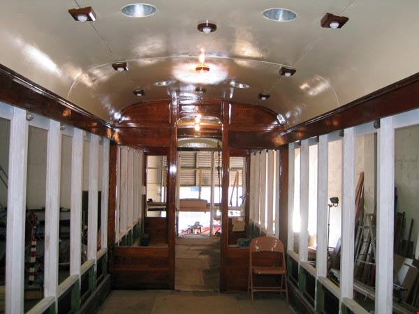
Interurban 1223 Volunteers Feb. 26, 2005
https://search.heritageburnaby.ca/link/archivedescription98462
- Repository
- City of Burnaby Archives
- Date
- February 26, 2005
- Collection/Fonds
- Burnaby Historical Society fonds
- Description Level
- File
- Physical Description
- 14 photographs (jpgs) on 1 optical disc
- Scope and Content
- File contains photographs of volunteers working on the restoration of interurban tram 1223.
- Repository
- City of Burnaby Archives
- Date
- February 26, 2005
- Collection/Fonds
- Burnaby Historical Society fonds
- Series
- Administration series
- Physical Description
- 14 photographs (jpgs) on 1 optical disc
- Description Level
- File
- Record No.
- 633-016
- Access Restriction
- No restrictions
- Reproduction Restriction
- No restrictions
- Accession Number
- 2020-06
- Scope and Content
- File contains photographs of volunteers working on the restoration of interurban tram 1223.
- Subjects
- Transportation - Electric Railroads
- Media Type
- Photograph
- Notes
- Transcribed title
- Title transcribed from optical disc label
- Street Address
- 6501 Deer Lake Avenue
- Historic Neighbourhood
- Burnaby Lake (Historic Neighbourhood)
- Planning Study Area
- Morley-Buckingham Area
Images
Donald N. Brown subseries
https://search.heritageburnaby.ca/link/archivedescription35
- Repository
- City of Burnaby Archives
- Date
- 1925 (date of original)-1995
- Collection/Fonds
- Burnaby Historical Society fonds
- Description Level
- Subseries
- Physical Description
- Textual records and other material
- Scope and Content
- Subseries consists of photographs taken by Freeman Donald N. Brown while involved in Burnaby Historical Society activities and textual records pertaining to his career with the Royal Canadian Mounted Police. Also included in the subseries are documents and photographs from his involvement with vari…
- Repository
- City of Burnaby Archives
- Date
- 1925 (date of original)-1995
- Collection/Fonds
- Burnaby Historical Society fonds
- Subseries
- Donald N. Brown subseries
- Physical Description
- Textual records and other material
- Description Level
- Subseries
- Accession Number
- BHS1987-03
- BHS2003-04
- BHS1992-20
- BHS1995-09
- BHS2000-10
- BHS1991-41
- BHS2001-12
- BHS2004-01
- BHS2004-12
- Scope and Content
- Subseries consists of photographs taken by Freeman Donald N. Brown while involved in Burnaby Historical Society activities and textual records pertaining to his career with the Royal Canadian Mounted Police. Also included in the subseries are documents and photographs from his involvement with various community groups including the Oakalla Lands Citizens' Committee, renovations of Burnaby Village Museum, and the restoration of Interurban tram no. 1223.
- History
- Donald Neil "Don" Brown was born in Birmingham, England. In 1922, while still an infant, he and his family moved to Winnipeg, Canada. On September 8, 1939, Don left his Senior Matriculation classes to join the Royal Canadian Engineers. Two weeks later, he eloped with his high school sweetheart, Helen J., just months before he was to be shipped overseas with the 3rd Contingent of Canadian Troops. He served in the army with the Royal Canadian Engineer’s 12th Field Company and saw action in both Sicily and Italy. In 1945, Don returned to obtain his Senior Matriculation and a year of university studies before re-enlisting in the army as a Second Lieutenant. He spent the next two years stationed in Chilliwack with Helen and their first child. In 1947, he left the army to join the ranks of the British Columbia Provincial Police force, embarking on a three-decade long career. His first assignment brought him to Burnaby where he served from 1947-1954, first as a member of the BC Police Department and then as a Royal Canadian Mounted Policeman. In 1954, Don was transferred to Regina, Saskatchewan and then to Ottawa, Ontario to serve in the Crime Detection Laboratories. He became a qualified Examiner of Questioned Documents and provided expert testimony in handwriting, counterfeiting, graphic arts, and alterations. He attained the rank of first Corporal, and then Sergeant in the RCMP. He was transferred to Vancouver to be the Second in Charge of a new laboratory and head of the Document Section in July, 1963. On December 9, 1967, Helen Brown ran as an independent for the position of Alderman on the Burnaby Council. She was not elected. In May 1970, Don was promoted to Sub-Inspector and transferred to Edmonton to take command of the new Crime Detection Laboratory. By 1972, he was promoted to full Inspector. Transferred back to Vancouver in 1975, Don became the Officer-in-Charge of a new Crime Laboratory and took over the National Police Services pilot project for British Columbia. He was rewarded for this work with a promotion to Superintendent in September 1975. In 1976, after a distinguished 35 years combined service to the armed forces and the police, Don retired and founded his own laboratory to carry on his work in the field of questioned documents. He became a Fellow (Emeritus) of the American Academy of Forensic Sciences, a Life Member (Emeritus) and Past Director of the Canadian Society of Forensic Sciences, a Member of the American Society of Questioned Document Examiners, and a Diplomate of the American Board of Forensic Document Examiners. After his retirement, Don became involved in local politics and, with the blessing of his wife and six children, joined the Burnaby Voters’ Association as their Secretary. In 1978 he was elected to a two-year term as a Burnaby School Trustee. During the next municipal election in November 1979, he successfully ran for Alderman. Don Brown served Burnaby as Alderman from 1979 to 1985. During this time, Don also became a member of the Community College for the Retired, the Horsemen’s Society and the Burnaby Historical Society. He also gave his support to Arts Council programs and numerous other community functions over the years and author "Why?: The Last Years of the British Columbia Policy 1858-1950" about the BC Provincial Police. In 1991, Don was appointed as Chair of the Burnaby Centennial Committee, dedicating himself to making Burnaby’s Centennial celebration a memorable success. His contributions were always supported by his wife Helen, and their work during the Centennial Year was just one example of the strength of their 66-year partnership. They were both formally recognized for their efforts when they were chosen to receive the Kushiro Cup and named the Citizens of the Year in 1992. Also that year, Don was a recipient of the Canadian 125 Medal and one year later, in March 1993, Donald Brown was awarded Burnaby’s highest honour and was made a Freeman of the City of Burnaby. Don passed away in 2009.
- Media Type
- Textual Record
- Photograph
- Moving Images
- Creator
- Brown, Donald N. "Don"
- Notes
- Title based on contents of fonds
- PC194, PC241, MSS098, MSS148
Eagles family subseries
https://search.heritageburnaby.ca/link/archivedescription39
- Repository
- City of Burnaby Archives
- Date
- 1912 -1995
- Collection/Fonds
- Burnaby Historical Society fonds
- Description Level
- Subseries
- Physical Description
- Textual records and photographs
- Scope and Content
- Subseries consists of records, correspondence, and photographs created by Drs. Blythe and Violet Eagles related to their home and garden in the Deer Lake area of Burnaby. Also included in the subseries are records pertaining the Burnaby Historical Society, the book "The Fraser's History from Glacie…
- Repository
- City of Burnaby Archives
- Date
- 1912 -1995
- Collection/Fonds
- Burnaby Historical Society fonds
- Subseries
- Eagles family subseries
- Physical Description
- Textual records and photographs
- Description Level
- Subseries
- Access Restriction
- No restrictions
- Accession Number
- BHS1990-11
- BHS1996-21
- BHS2000-04
- BHS1987-07
- BHS1995-06
- BHS1991-18
- BHS1995-03
- Scope and Content
- Subseries consists of records, correspondence, and photographs created by Drs. Blythe and Violet Eagles related to their home and garden in the Deer Lake area of Burnaby. Also included in the subseries are records pertaining the Burnaby Historical Society, the book "The Fraser's History from Glaciers to Early Settlements" and the Eagles' visit to Robert Burnaby's grave.
- History
- Blythe Eagles's paternal grandparents Charles and Maude Eagles immigrated to New Westminster in 1887. Their son Jack married Amelia Jane Johnston, and Blythe Eagles was born in New Westminster in 1902. In 1918, Blythe enrolled at the University of British Columbia and took a Physiology class with eight other top students; his future wife, Violet Dunbar, was the lone woman in the class. Blythe graduated in 1922, winning the Governor General's Gold Medal as top student. He received his MA in 1924 and his PhD in 1926 from the University of Toronto. He then completed his post-doctoral study at the National Institute for Medical Research in London, England. In 1933, Dr. Eagles became head of the Department of Dairying (1936-1955), Chairman of the Division of Animal Science (1955-1967), and Dean of the Faculty of Agriculture (in 1949 until his retirement in 1967). In 1968 he received an Honourary Doctor of Science Award from UBC. Blythe was also one of the first appointments to the Burnaby Town Planning Commission. Violet Evelyn Dunbar was born September 29, 1899 in Ontario, the eldest child of John and Mary (Tompson) Dunbar. Violet obtained her BA in 1921 and MA in 1922 from the University of British Columbia. In 1922 she attended the Provincial Normal School and within six months had a teaching certificate and taught at Lord Hudson School in 1923. In September 1923, she was awarded a two-year scholarship to the University of Toronto, where she joined Blythe in the Bio-Chemistry Department. She received a second MA and a PhD in 1929. Her graduate studies entailed research in pure proteins and enzymes related to the commercial production of cheese. Through this work, she was recognized as one of the leading enzyme chemists in the country, being a senior lab instructor of biochemistry. Violet was one of the founders of the Burnaby Council of Women and active member of the International Council of Women. Blythe and Violet Eagles purchased property at Deer Lake in 1929 and began construction of their home shortly before their marriage on June 25, 1930. The Drs. Blythe and Violet Eagles Estate is a unique expression of the talents and tastes of both the Eagles and Frank Ebenezer Buck (1875-1970), who was head of the Horticultural Department and the Campus Landscape Architect at U.B.C. and established the plan for the Eagles garden while Blythe selected many of the plantings. The Eagles themselves designed the house as a romantic cottage inspired by the British Arts and Crafts style. Violet was an enthusiastic amateur gardener, maintaining and continually developing the garden. The Eagles were active volunteers in the local community as well as at UBC. When Simon Fraser University opened in Burnaby, they became well-known for entertaining dignitaries and special guests of the university in their lavish garden. After Violet's death in 1993, the estate was sold to the City of Burnaby. The funds were used to establish a Chair in Agriculture at the University of British Columbia in their memory.
- Media Type
- Textual Record
- Photograph
- Creator
- Eagles, Dr. Blythe
- Eagles, Dr. Violet
- Notes
- Title based on creator and contents of subseries
- PC245, PC331, PC404, MSS032, PC314, PC482, MSS055
Bancroft family subseries
https://search.heritageburnaby.ca/link/archivedescription63795
- Repository
- City of Burnaby Archives
- Date
- [1900]-1979
- Collection/Fonds
- Burnaby Historical Society fonds
- Description Level
- Subseries
- Physical Description
- Textual records and other materials
- Scope and Content
- Subseries consists of publications, correspondence and other miscellaneous papers relating to the Bancroft family's interests and work history. Topics include gardening, raising poultry, the Liberal government and the Royal Canadian Air Force. Also included in the subseries are photographs of the…
- Repository
- City of Burnaby Archives
- Date
- [1900]-1979
- Collection/Fonds
- Burnaby Historical Society fonds
- Subseries
- Bancroft family subseries
- Physical Description
- Textual records and other materials
- Description Level
- Subseries
- Accession Number
- BHS1986-44
- BHS2004-06
- Scope and Content
- Subseries consists of publications, correspondence and other miscellaneous papers relating to the Bancroft family's interests and work history. Topics include gardening, raising poultry, the Liberal government and the Royal Canadian Air Force. Also included in the subseries are photographs of the Bancroft family and friends and ephemera pertaining to agricultural farming and the air force.
- History
- Rose Croucher was born to Ann Eliza "Annie" (b. August 1861, d. 1962) and R. Coucher in January 1895. In 1907, the Croucher family moved to British Columbia. As a student, Rose studied geometrical drawing using Blair’s Canadian Drawing Series workbooks. On on February 21, 1914, Rose married James Oakes Bancroft in Vancouver, BC. Together they had three children: James A. (b. 1916 or 1917), Rosie (date unknown), and George E. (b. August 1927). The Bancroft family were poultry farmers throughout the early 1900s, transporting their farmed eggs from Burnaby to the Hudson’s Bay Company Vancouver using the British Columbia Electric Railway system. Rose Bancroft also served as Secretary-Treasurer of the Central Park Poultry Co-op Association in the 1920s until her husband's death in 1930 at the age of 42. In the late thirties and early forties, while James A. Bancroft was stationed in Calgary with the Royal Canadian Air Force, his younger siblings lived together with their mother and grandmother at 1963 21st Avenue in Burnaby. Rosie Bancroft studied French and English history in Social Studies in 1937; her brother George studied the seasons in General Science II in 1942. Rose died in 1965 at the age of 76.
- Media Type
- Textual Record
- Photograph
- Cartographic Material
- Creator
- Bancroft, Rose
- Notes
- MSS030, PC490, PC507, and MSS110
- Title based on creator and contents of subseries
Hazel Peterson subseries
https://search.heritageburnaby.ca/link/archivedescription62793
- Repository
- City of Burnaby Archives
- Date
- [188-]-[2000]
- Collection/Fonds
- Burnaby Historical Society fonds
- Description Level
- Subseries
- Physical Description
- Photographs and textual records
- Scope and Content
- Subseries consists of photographs and textual records, including marriage and baptism certificates, belonging to Hazel Erickson Peterson and her family.
- Repository
- City of Burnaby Archives
- Date
- [188-]-[2000]
- Collection/Fonds
- Burnaby Historical Society fonds
- Subseries
- Hazel Peterson subseries
- Physical Description
- Photographs and textual records
- Description Level
- Subseries
- Accession Number
- BHS2000-08
- Scope and Content
- Subseries consists of photographs and textual records, including marriage and baptism certificates, belonging to Hazel Erickson Peterson and her family.
- History
- Hazel Eleanora Erickson was born May 21, 1896 in San Francisco California and baptized on December 25, 1899. She was the daughter of Charles Victor Erickson and Amanda Hedvig Erickson of Sweden. Her parents were married in Oakland, California on January 20, 1894. The Erickson family lived in San Francisco, then travelled up the panhandle to Alaska. They travelled throughout British Columbia and by the 1920s made Burnaby their home. Hazel Erickson was living at Gibson's Landing, British Columbia by the time of her marriage on August 31, 1936 to Edwin Peterson. Edwin Peterson was born at sea on October 18, 1884 and became naturalized as a British subject from the Dominion of Canada in 1921. He was an electrician by trade. Hazel resided at the Dania Home in Burnaby for 20 before her death in 1996.
- Media Type
- Photograph
- Textual Record
- Creator
- Peterson, Hazel Erickson
- Notes
- Title based on creator of subseries
- MSS094, PC504
J.P. Dickson subseries
https://search.heritageburnaby.ca/link/archivedescription58383
- Repository
- City of Burnaby Archives
- Date
- 1920-1939 (dates of originals)
- Collection/Fonds
- Burnaby Historical Society fonds
- Description Level
- Subseries
- Physical Description
- Textual records and photographs
- Scope and Content
- Subseries consists of photocopied scrapbook pages as well as three original photographs pertaining to J.P. Dickson.
- Repository
- City of Burnaby Archives
- Date
- 1920-1939 (dates of originals)
- Collection/Fonds
- Burnaby Historical Society fonds
- Subseries
- J.P. Dickson subseries
- Physical Description
- Textual records and photographs
- Description Level
- Subseries
- Accession Number
- BHS1992-51
- Scope and Content
- Subseries consists of photocopied scrapbook pages as well as three original photographs pertaining to J.P. Dickson.
- History
- James P. Dickson was born in Peeblesshire, Scotland. He came to Manitoba first in 1905 when he was 21 years old, but didn’t move to British Columbia until 1909 when he started the Dickson Brothers Flower Shop and Nursery at 3271 Kingsway. He was a landscape gardener, designing the garden for the Model Burnaby Home at the Royal City Fair in 1920 and designing Burnaby exhibits at the provincial fairs at New Westminster in 1922 and 1923. In 1922 he spoke at a South Vancouver Horticultural Association event; the subject of his talk was “Natural Gardens.” J.P. Dickson was a Burnaby School Board Trustee from 1921 to 1924 (chairman in 1924), 1927 to 1932 (chairman from 1929 to 1932) and 1943 to 1944. In 1925 he was the Labour Party Candidate for Reeve of Burnaby. In 1930 he was president of the May Day committee and officiated at the crowning. J.P. Dickson attended the British Columbia School Trustees Association 26th Annual Convention in Vernon with his family and served as the association’s president from 1932 to 1933. The Dickson family lived at 1519 (later 7770) Nelson Avenue, Burnaby. J.P. had at least one child born about 1913, who attended South Burnaby High School in his teen years. According to “Burnaby: A Proud Century” by Pixie McGeachie James Dickson is also known for his part in creating an unofficial presentation to the King George and Queen Elizabeth during their royal visit in 1939. There was no official stop scheduled for Burnaby, but he persuaded the parade marshal beforehand to slow the procession as it approached Royal Oak (and the Chamber of Commerce built a viewing platform there to attract a large crowd). Dickson encouraged everyone to move in to narrow the width of passage on Kingsway. As the royal car appeared on Royal Oak, the crowd surged forward and blocked its path. A Burnaby girl rushed towards the car waving a bouquet from the Dickson Brothers Flower Shop and an aide-du-camp passed it directly to the Queen “who acknowledged the gift with approval just as the car began to move again.”
- Media Type
- Textual Record
- Photograph
- Creator
- Dickson, James P.
- Notes
- Title based on contents of subseries
- PC308 and MSS079
![Seventh Annual Ukrainian Cultural Festival, [2002] thumbnail](/media/hpo/_Data/_Archives_Images/_Unrestricted/535/535-2342-2.jpg?width=280)
Seventh Annual Ukrainian Cultural Festival
https://search.heritageburnaby.ca/link/archivedescription96743
- Repository
- City of Burnaby Archives
- Date
- [2002]
- Collection/Fonds
- Burnaby NewsLeader photograph collection
- Description Level
- File
- Physical Description
- 2 photographs (tiff) : col.
- Scope and Content
- File contains photographs of the seventh annual Ukrainian Cultural Festival, held at the Michael J. Fox Theatre. Photographs depict a performance of a traditional dance by several young performers, and Katy Wheelhouse dressing in preparation for a performance with her mother, Sonja.
- Repository
- City of Burnaby Archives
- Date
- [2002]
- Collection/Fonds
- Burnaby NewsLeader photograph collection
- Physical Description
- 2 photographs (tiff) : col.
- Description Level
- File
- Record No.
- 535-2342
- Access Restriction
- No restrictions
- Reproduction Restriction
- No restrictions
- Accession Number
- 2018-12
- Scope and Content
- File contains photographs of the seventh annual Ukrainian Cultural Festival, held at the Michael J. Fox Theatre. Photographs depict a performance of a traditional dance by several young performers, and Katy Wheelhouse dressing in preparation for a performance with her mother, Sonja.
- Names
- Michael J. Fox Theatre
- Media Type
- Photograph
- Photographer
- Bartel, Mario
- Notes
- Title based on caption
- Collected by editorial for use in a May 2002 issue of the Burnaby NewsLeader
- Caption from metadata for 535-2342-1: "A Ukrainian dance troupe performs at the 7th Annual Ukrainian Cultural Festival at Micheal J. Fox Theatre on Saturday. Dancers from around British Columbia and Alberta competed in various styles of Ukrainian dance and celebrated their heritage with Ukrainian music and craft displays."
- Caption from metadata for 535-2342-2: "Katy Wheelhouse gets a little with her headdress from her mom, Sonja, before competing with the Kvitka Ukrainian Dance Group at the 7th Annual Ukrainian Cultural at Burnaby's Micheal J. Fox Theatre. Dancers from around British Columbia and Alberta competed in various styles of Ukrainian dance and celebrated their heritage with Ukrainian music and craft displays."
- Geographic Access
- MacPherson Avenue
- Street Address
- 7373 MacPherson Avenue
- Planning Study Area
- Clinton-Glenwood Area
Images
![Seventh Annual Ukrainian Cultural Festival, [2002] thumbnail](/media/hpo/_Data/_Archives_Images/_Unrestricted/535/535-2342-2.jpg)