Narrow Results By
Subject
- Buildings - Heritage 3
- Buildings - Residential - Houses 3
- Cemeteries 1
- Construction 1
- Geographic Features - Gardens 3
- Occupations - Nurses 1
- Officials 1
- Officials - Mayors and Reeves 2
- Planning - City Planning 1
- Protests and Demonstrations 1
- Transportation - Bicycles 1
- Transportation - Public Transit 1
![SkyTrain consultation, [1999] thumbnail](/media/hpo/_Data/_Archives_Images/_Unrestricted/535/535-3127.jpg?width=280)
SkyTrain consultation
https://search.heritageburnaby.ca/link/archivedescription98047
- Repository
- City of Burnaby Archives
- Date
- [1999]
- Collection/Fonds
- Burnaby NewsLeader photograph collection
- Description Level
- Item
- Physical Description
- 1 photograph (tiff) : col.
- Scope and Content
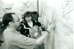
- Photograph of two unidentified people at a public consultation. They are viewing maps and aerial photographs related to the SkyTrain line.
- Repository
- City of Burnaby Archives
- Date
- [1999]
- Collection/Fonds
- Burnaby NewsLeader photograph collection
- Physical Description
- 1 photograph (tiff) : col.
- Description Level
- Item
- Record No.
- 535-3127
- Access Restriction
- No restrictions
- Reproduction Restriction
- No restrictions
- Accession Number
- 2018-12
- Scope and Content
- Photograph of two unidentified people at a public consultation. They are viewing maps and aerial photographs related to the SkyTrain line.
- Media Type
- Photograph
- Notes
- Title based on contents of photograph
- Collected by editorial for use in a February 1999 issue of the Burnaby NewsLeader
Images
![SkyTrain consultation, [1999] thumbnail](/media/hpo/_Data/_Archives_Images/_Unrestricted/535/535-3127.jpg)
Advisory Planning Commission subseries
https://search.heritageburnaby.ca/link/archivedescription96030
- Repository
- City of Burnaby Archives
- Date
- [1960]-2012
- Collection/Fonds
- City Council and Office of the City Clerk fonds
- Description Level
- Subseries
- Physical Description
- 40 folders of textual records + 1 photograph
- Scope and Content
- Subseries consists of commission records for the Advisory Planning Commission including agendas, minutes, reports, and correspondence and a Commission portrait.
- Repository
- City of Burnaby Archives
- Date
- [1960]-2012
- Collection/Fonds
- City Council and Office of the City Clerk fonds
- Series
- Council Committee series
- Subseries
- Advisory Planning Commission subseries
- Physical Description
- 40 folders of textual records + 1 photograph
- Description Level
- Subseries
- Scope and Content
- Subseries consists of commission records for the Advisory Planning Commission including agendas, minutes, reports, and correspondence and a Commission portrait.
- History
- The Advisory Planning Commission was established in July of 1963. The Advisory Planning Commission was the successor to the Town Planning Commission. The Commission was responsible for advising Council on land use matters and reviewing all zoning bylaw amendments before being forwarded to public hearing. The Commission was disbanded on February 20, 2017.
- Media Type
- Textual Record
- Photograph
- Graphic Material
Planning Department fonds
https://search.heritageburnaby.ca/link/archivedescription102
- Repository
- City of Burnaby Archives
- Date
- 1940-2016
- Collection/Fonds
- Planning Department fonds
- Description Level
- Fonds
- Physical Description
- 80 m of textual records and other material
- Scope and Content
- Fonds consists of those records created during the regular conduct of business by the Planning Department and its predecessor agencies according to their mandate of providing professional and technical advice to Council on the current and future uses of City land and resources.
- Repository
- City of Burnaby Archives
- Date
- 1940-2016
- Collection/Fonds
- Planning Department fonds
- Physical Description
- 80 m of textual records and other material
- Description Level
- Fonds
- File Class
- 71000 10 (add. 2020)
- 71000 20 (add. 2020)
- 71000 30 (add. 2020)
- 71000 40 (add. 2020)
- Access Restriction
- Subject to FOIPPA
- Reproduction Restriction
- Reproductions subject to FOIPPA.
- Scope and Content
- Fonds consists of those records created during the regular conduct of business by the Planning Department and its predecessor agencies according to their mandate of providing professional and technical advice to Council on the current and future uses of City land and resources.
- History
- The City of Burnaby Planning Department was established on October 9, 1956, when the City Council unanimously carried the motion to create a distinct department to deal with planning issues within the City and appointed Mr. William John Blakely as its head. This decision followed a report and recommendation made by the City’s Chief Administrative Officer which indicated that the role of the Planning Engineer and his staff had quickly expanded to become a separate division within the Engineering Department and that they were functioning as an independent unit in all but name. The proposed separation of the Engineering and Planning departments had been in the works since the early part of 1956 when staff changes and restructuring within the Engineering Department’s Planning Division illustrated the undermanned condition of the Planning Engineer’s office. As a result, Council asked the Chief Administrative Officer to undertake a study examining the feasibility of creating a distinct Planning Department. This report was delivered to Council on July 3, 1956, but was laid over until a Committee of the Council had the opportunity to study the functions of the Planning department to determine the necessity of the proposal. The Committee’s findings were in line with the initial report and the Planning Department was established with a staff of nine (the head Planning Engineer, an Administrative Planner, three Research Planning Assistants, a Draughtsman, a Subdivision Control Clerk, a department Clerk and a Clerk Stenographer). This new department was to offer advice and carry out the work intensive in matters such as zoning and rezoning applications, subdivision control, traffic and transportation planning, and general City planning schemes. Prior to the creation of the Planning Department, a number of bodies within the City had been responsible for fulfilling the functions carried out by this new unit. In the earliest years of the City, the members of Council were responsible for matters of planning and were assisted in their job by the City’s Engineer or any number of hired consultants (e.g. surveyors, cartographers). By 1906, however, the provincial laws surrounding the subdivision process had changed, and local governments were charged with the task of approving all private subdivision plans in their respective Municipalities. In Burnaby, the City Council passed a bylaw decreeing that all subdivision plans were to be submitted to Council for review and the City Engineer was responsible for ensuring compliance with the law. After the first Town Planning Bylaw in 1924 which restricted the type and size of construction that could occur in certain City areas, the Engineering and Building departments were to work together to oversee the enforcement of the Bylaw and the development of City plans. The scope and competence required to carry out this work grew as Burnaby’s population expanded, and in 1930 Council passed the Town Planning Commission Bylaw (No. 1028) that saw the creation of a permanent body – the Town Planning Commission – which was to serve as an advisory body to help direct the planning activities in the City while the actual work continued to be carried out by the Engineering Department. This body was comprised of the Reeve, the Chairman of the School Board, the Chairman of the Park Committee (later, the Board of Parks Commissioners), and six appointed citizens who served three-year terms. Council referred all matters of subdivisions, transportation planning, and rezoning to this Commission, which was later supported in its work by several other special or standing committees such as the Subdivision Committee, the Apartment Committee, the Transportation Committee or the Town Planning Board of Appeal. By 1953, it had become apparent that the advisory committees that were dedicated to these planning issues needed a permanent staff to carry out the work intensive, so a restructuring of the Engineering department resulted in a permanent Planning Engineer’s office being created. The Town Planning Commission continued in its advisory capacity even after the determination came in 1956 to create a separate Planning Department. When Bylaw No. 4473 was passed in 1963, the Town Planning Commission was disbanded in favour of a new Advisory Planning Commission that would turn over all routine matters such as subdivision and rezoning applications to the Planning Department but would offer advice and community input into the more complex planning schemes within the City and act as an intermediary in cases where Council and Planning staff were in disagreement. A new Advisory Planning Commission Bylaw (No. 7600) was adopted in 1980 which allowed for even greater community participation in the planning process. The Planning Department was initially responsible to report directly to Council, but in 1957, the administrative structure of Municipal staff changed with the introduction of the Burnaby Municipal Manager Bylaw (No. 3859) and from that point on, the head of the Planning Department held a direct reporting relationship to the Municipal Manager, who in turn was responsible for reporting the activities of the Department to the City Council. Over the years, the internal structure and the scope of responsibilities of the Department have changed during periods of staff reorganizations. Under the larger umbrella of the Planning and Building Department, Planning has come to be comprised of two divisions: the Current Planning Division and the Long Range Planning Division. The functions of the Current Planning Division include rezoning, subdivision, development plan areas, preliminary plan approvals, urban design, heritage planning, and urban trails and bicycle routes. The Long Range Planning Division is responsible for environmental planning concerns, transportation planning, housing, neighbourhood area planning, social planning and planning information services. In 2022, the Planning and Building Department was reorganized to better align functions with delivery of services. The Climate Action and Engery Division moved from Corporate Services to the Planning and Building Department, while Indigenous Relations and Facilities Management moved to Corporate Services and Lands and Facilities, respectively. The position of Director of Planning and Building was changed to General Manager, Planning and Development. The following individuals have served as Planning Engineer and/or Director of the Planning Department and/or General Manager, Planning and Development for the City of Burnaby: William John Blakely 1954-1956 (as Planning Engineer) 1956-1963 (as Head of the Department) Anthony P. Parr 1964-1993 Don G. Stenson 1993-2001 Jack S. Belhouse 2001-2006 Basil Luksun 2006-2012 Lou Pelletier 2012-2019 Edward Kozak 2019-present
- Formats
- Microforms exist for some records. See series descriptions.
- Media Type
- Textual Record
- Photograph
- Moving Images
- Creator
- City of Burnaby
- Notes
- Title based on contents of fonds
Planning photograph series
https://search.heritageburnaby.ca/link/archivedescription178
- Repository
- City of Burnaby Archives
- Date
- 1910-2005
- Collection/Fonds
- Planning Department fonds
- Description Level
- Series
- Physical Description
- ca. 6000 photographs
- Scope and Content
- Series consists of photographs created, and/or used by the Planning Department in the course of preparing reports, studies, publications, or displays. Subjects of the photographs vary, but include street scenes, prominent buildings, aerial views of Burnaby and Simon Fraser University, and photogra…
- Repository
- City of Burnaby Archives
- Date
- 1910-2005
- Collection/Fonds
- Planning Department fonds
- Series
- Planning photograph series
- Physical Description
- ca. 6000 photographs
- Description Level
- Series
- Accession Number
- 2001-02
- 2002-03
- 2002-06
- 2003-15
- 2004-16
- 2010-09
- 2012-15
- 2016-09
- Scope and Content
- Series consists of photographs created, and/or used by the Planning Department in the course of preparing reports, studies, publications, or displays. Subjects of the photographs vary, but include street scenes, prominent buildings, aerial views of Burnaby and Simon Fraser University, and photographs taken at certain Burnaby events.
- Media Type
- Photograph
- Notes
- Photo catalogue 502

Sussex-Nelson Neighbourhood
https://search.heritageburnaby.ca/link/landmark838
- Repository
- Burnaby Heritage Planning
- Associated Dates
- 1955-2008
- Heritage Value
- The Sussex-Nelson Neighbourhood is located just south of Metrotown and in 1980 was characterised as the most populated of all of Burnaby's Planning Study areas. The area immediately south of Metrotown was initially developed as post-war 1950s housing stock, while the sector south of Rumble was developed after the 1960s and 1970s as single-family housing.
- Historic Neighbourhood
- Alta Vista (Historic Neighbourhood)
- Planning Study Area
- Sussex-Nelson Area
Images


Oakalla Neighbourhood
https://search.heritageburnaby.ca/link/landmark804
- Repository
- Burnaby Heritage Planning
- Associated Dates
- 1955-2008
- Heritage Value
- The phasing out and demolition of the Oakalla Prison farm allowed for the planned development of the Oakalla Neighbourhood in the 1980s. By 1991, the City of Burnaby had adopted the Oakalla Development Plan which called for the transfer of land to the Deer Lake Park reserve as well as the creation of a new residential area consisting of multi-family housing types.
- Historic Neighbourhood
- Central Park (Historic Neighbourhood)
- Planning Study Area
- Oakalla Area
Images


Big Bend Neighbourhood
https://search.heritageburnaby.ca/link/landmark840
- Repository
- Burnaby Heritage Planning
- Associated Dates
- 1955-2008
- Heritage Value
- The Big Bend Neighbourhood in Burnaby maintained its status as an important agricultural area in the City in the years following 1955 and it also solidified its role as a prime industrial and commercial district. In 1972, the Big Bend Development Plan was adopted by Council and soon thereafter, approximately 620 acres of land were incorporated into the Agricultural Land Reserve. These lands have been set aside for agricultural and limited recreation purposes. By the 2000s, 160 acres of land were considered highly productive agricultural areas, and over 400 acres of land had been secured as parkland, including the Fraser Foreshore Park. The area also developed large commercial and industrial districts including those at Marine Way/Boundary, the Glenlyon Estates, Riverfront Business Park, Burnaby Business Park, and Glenwood Industrial Estates.
- Historic Neighbourhood
- Fraser Arm (Historic Neighbourhood)
- Planning Study Area
- Big Bend Area
Images


Burnaby Lake Neighbourhood
https://search.heritageburnaby.ca/link/landmark821
- Repository
- Burnaby Heritage Planning
- Associated Dates
- 1955-2008
- Heritage Value
- In 1966 Burnaby Lake was identified as a key potential regional park in the GVRD ’s Regional Park Plan for the Lower Mainland. The lake was to be developed for nature study, strolling, trail riding, canoeing, sightseeing and picnicking. It was formally recognized as a regional nature park in 1979, at which time the GVRD assumed management of the park through a lease agreement with the City of Burnaby. In 1993 Burnaby Lake was selected by the City of Burnaby to be included in Greater Vancouver ’s Green Zone, and was identified as a key component of the GVRD ’s Park and Outdoor Recreation System (PORS) for the Burrard/Peninsula/Richmond sector, which includes Burnaby, Vancouver, New Westminster, and Richmond.
- Historic Neighbourhood
- Burnaby Lake (Historic Neighbourhood)
- Planning Study Area
- Burnaby Lake Area
Images


Clinton-Glenwood Neighbourhood
https://search.heritageburnaby.ca/link/landmark841
- Repository
- Burnaby Heritage Planning
- Associated Dates
- 1955-2008
- Heritage Value
- The primarily single-family subdivision and development in the Clinton-Glenwood Neighbourhood occurred during the building boom of the 1950s. Later development fell under the guidelines established in the Royal Oak Community Plan (adopted in 1999) and resulted in an increase in the number of multi-family units.
- Historic Neighbourhood
- Alta Vista (Historic Neighbourhood)
- Planning Study Area
- Clinton-Glenwood Area
Images


South Slope Elementary School & The B.C. Provincial School for the Deaf
https://search.heritageburnaby.ca/link/landmark843
- Repository
- Burnaby Heritage Planning
- Geographic Access
- Watling Street
- Associated Dates
- 1992
- Heritage Value
- South Slope/B.C. School for the Deaf opened in 1992 and is one of the newer elementary schools in the City. The 2009 School Growth Plan notes that South Slope/BC School for the Deaf replaced the former Jericho Hill School for the Deaf in Vancouver.
- Historic Neighbourhood
- Alta Vista (Historic Neighbourhood)
- Planning Study Area
- Sussex-Nelson Area
- Street Address
- 4446 Watling Street
- Street View URL
- Google Maps Street View
Images


Stride Avenue Neighbourhood
https://search.heritageburnaby.ca/link/landmark845
- Repository
- Burnaby Heritage Planning
- Associated Dates
- 1955-2008
- Heritage Value
- The interurban link between New Westminster and Vancouver stimulated the early settlement of Stride Avenue. Infilling of the area took place in the early 1950s and the pace of development had slowed considerably by 1970. Duplexes became a popular feature in the decade between 1970 and 1980 and in the late 1980s, the neighbourhood was incorporated into the Edmonds Town Centre South plan.
- Historic Neighbourhood
- Edmonds (Historic Neighbourhood)
- Planning Study Area
- Stride Avenue Area
Images


Stride Hill Neighbourhood
https://search.heritageburnaby.ca/link/landmark846
- Repository
- Burnaby Heritage Planning
- Associated Dates
- 1955-2008
- Heritage Value
- The residential areas that are located within the Stride Hill Neighbourhood were primarily developed in the 1950s during Burnaby's post-war building boom. The area lying to the south of Byrne Creek Ravine Park was used as a municipal garbage dump until the 1960s and as a landfill site for yard waste disposal until the early 1990s at which point the area was incorporated into the Edmonds Town Centre Plan and the land was made into park and open space.
- Historic Neighbourhood
- Edmonds (Historic Neighbourhood)
- Planning Study Area
- Stride Hill Area
Images


Windsor Neighbourhood
https://search.heritageburnaby.ca/link/landmark803
- Repository
- Burnaby Heritage Planning
- Associated Dates
- 1955-2008
- Heritage Value
- The Windsor Neighbourhood comprises a number of different districts with different characteristics. To the north, stretching to the border of the Deer Lake Park, is the primarily residential area that was developed after the building boom of the 1950s and now consists of a mix of single-family and multi-family housing. To the south, from Kingsway to the Skytrain line, an industrial area was maintained along with a significant commercial corridor along Kingsway. In recent years, the growth and development of this area has been guided by the Royal Oak Community Plan adopted by Council in 1999.
- Planning Study Area
- Windsor Area
Images


Sperling-Broadway Neighbourhood
https://search.heritageburnaby.ca/link/landmark789
- Repository
- Burnaby Heritage Planning
- Associated Dates
- 1955-2008
- Heritage Value
- By the 1970s, the Sperling-Broadway Neighbourhood was characterised as one of the Municipality's fastest growing residential areas. In 1980, it was estimated that slightly less than half of the homes were single-family residences, while the remaining development was taking the form of townhouse and high-rise apartments. The emphasis shifted back to single family housing during the construction of planned subdivisions such as the Camrose subdivision in the 1980s and the area remains primarily residential in nature. The neighbourhood is well-served by park facilities and is also home to the Burnaby Mountain Golf Course.
- Historic Neighbourhood
- Lochdale (Historic Neighbourhood)
- Planning Study Area
- Sperling-Broadway Area
Images

Bill Copeland with Jon Grant
https://search.heritageburnaby.ca/link/archivedescription79309
- Repository
- City of Burnaby Archives
- Date
- July 3, 1996
- Collection/Fonds
- Burnaby NewsLeader photograph collection
- Description Level
- Item
- Physical Description
- 1 photograph : col. ; 11 x 17.5 cm
- Scope and Content
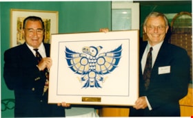
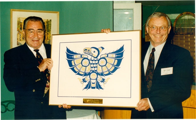
- Photograph of Burnaby mayor Bill Copeland presenting Chairman of Canada Lands Company Jon Grant with the City of Burnaby's Inaugural Environment Award for Planning and Development for their Glenlyon Business Park Development Plan.
- Repository
- City of Burnaby Archives
- Date
- July 3, 1996
- Collection/Fonds
- Burnaby NewsLeader photograph collection
- Physical Description
- 1 photograph : col. ; 11 x 17.5 cm
- Description Level
- Item
- Record No.
- 535-0337
- Access Restriction
- No restrictions
- Reproduction Restriction
- No reproduction permitted
- Accession Number
- 2012-11
- Scope and Content
- Photograph of Burnaby mayor Bill Copeland presenting Chairman of Canada Lands Company Jon Grant with the City of Burnaby's Inaugural Environment Award for Planning and Development for their Glenlyon Business Park Development Plan.
- Subjects
- Officials - Mayors and Reeves
- Media Type
- Photograph
- Notes
- Title based on contents of photograph
- Note in black ink on verso of photograph reads: "Vancouver, June 1996 - Canada Lands Company Receives the City of Burnaby's Inaugural Environment Award for Planning and Development for their Glenlyon Business Park Development Plan. Mayor Bill Copeland (left) from the City of Burnaby presents the award to Mr. Jon Grant, (right) Chairman of Canada Lands Company. "
- Scan is cropped
Images
Eagles family fonds
https://search.heritageburnaby.ca/link/archivedescription97217
- Repository
- City of Burnaby Archives
- Date
- 1919-1995
- Collection/Fonds
- Eagles family fonds
- Description Level
- Fonds
- Physical Description
- 40 files of textual records and 1489 photographs (6 col. prints, 10 x 15 cm; 1,444 col. slides, 35 mm).
- Scope and Content
- Collection consists of records, correspondence, and photographs created by Drs. Blythe and Violet Eagles related to their home and garden in the Deer Lake area of Burnaby. Also included in the collection are records pertaining the Burnaby Historical Society, the book "The Fraser's History from Glac…
- Repository
- City of Burnaby Archives
- Date
- 1919-1995
- Collection/Fonds
- Eagles family fonds
- Physical Description
- 40 files of textual records and 1489 photographs (6 col. prints, 10 x 15 cm; 1,444 col. slides, 35 mm).
- Description Level
- Fonds
- Access Restriction
- No restrictions
- Reproduction Restriction
- May be restricted by third party rights
- Accession Number
- 2008-10
- Scope and Content
- Collection consists of records, correspondence, and photographs created by Drs. Blythe and Violet Eagles related to their home and garden in the Deer Lake area of Burnaby. Also included in the collection are records pertaining the Burnaby Historical Society, the book "The Fraser's History from Glaciers to Early Settlements" and the Eagles' visit to Robert Burnaby's grave.
- History
- Blythe Eagles's paternal grandparents, Charles and Maude Eagles, immigrated to New Westminster in 1887. Their son Jack married Amelia Jane Johnston, and Blythe Eagles was born in New Westminster in 1902. In 1918, Blythe enrolled at the University of British Columbia and took a Physiology class with eight other top students. His future wife, Violet Dunbar, was the lone woman in the class. Blythe graduated in 1922, winning the Governor General's Gold Medal as top student. He received his MA in 1924 and his PhD in 1926 from the University of Toronto. He then completed his post-doctoral study at the National Institute for Medical Research in London, England. In 1933, Dr. Eagles became head of the Department of Dairying (1936-1955), Chairman of the Division of Animal Science (1955-1967), and Dean of the Faculty of Agriculture (in 1949 until his retirement in 1967). In 1968, he received an Honorary Doctor of Science Award from UBC. Blythe was also one of the first appointments to the Burnaby Town Planning Commission. Violet Evelyn Dunbar was born September 29, 1899, in Ontario, the eldest child of John and Mary (Tompson) Dunbar. Violet obtained her BA in 1921 and MA in 1922 from the University of British Columbia. In 1922, she attended the Provincial Normal School and, within six months, had a teaching certificate and taught at Lord Hudson School in 1923. In September 1923, she was awarded a two-year scholarship to the University of Toronto, where she joined Blythe in the Bio-Chemistry Department. She received a second MA and a PhD in 1929. Her graduate studies entailed research in pure proteins and enzymes related to the commercial production of cheese. Through this work, she was recognized as one of the leading enzyme chemists in the country, being a senior lab instructor of biochemistry. Violet was one of the founders of the Burnaby Council of Women and active member of the International Council of Women. Blythe and Violet Eagles purchased property at Deer Lake in 1929 and began construction of their home shortly before their marriage on June 25, 1930. The Drs. Blythe and Violet Eagles Estate is a unique expression of the talents and tastes of both the Eagles and Frank Ebenezer Buck (1875-1970), who was head of the Horticultural Department and the Campus Landscape Architect at U.B.C. and established the plan for the Eagles garden while Blythe selected many of the plantings. The Eagles themselves designed the house as a romantic cottage inspired by the British Arts and Crafts style. Violet was an enthusiastic amateur gardener, maintaining and continually developing the garden. The Eagles were active volunteers in the local community as well as at UBC. When Simon Fraser University opened in Burnaby, they became well-known for entertaining dignitaries and special guests of the university in their lavish garden. After Violet's death in 1993, the estate was sold to the City of Burnaby. The funds were used to establish a Chair in Agriculture at the University of British Columbia in their memory.
- Media Type
- Textual Record
- Photograph
- Other Title Information
- Title was changed from Eagles family collection to Eagles family fonds to better reflect the nature of the materials.
- Notes
- Title based on contents of collection
- BHS245, BHS331, BHS404, MSS032, BHS314, BHS482, MSS055
Eagles family subseries
https://search.heritageburnaby.ca/link/archivedescription39
- Repository
- City of Burnaby Archives
- Date
- 1912 -1995
- Collection/Fonds
- Burnaby Historical Society fonds
- Description Level
- Subseries
- Physical Description
- Textual records and photographs
- Scope and Content
- Subseries consists of records, correspondence, and photographs created by Drs. Blythe and Violet Eagles related to their home and garden in the Deer Lake area of Burnaby. Also included in the subseries are records pertaining the Burnaby Historical Society, the book "The Fraser's History from Glacie…
- Repository
- City of Burnaby Archives
- Date
- 1912 -1995
- Collection/Fonds
- Burnaby Historical Society fonds
- Subseries
- Eagles family subseries
- Physical Description
- Textual records and photographs
- Description Level
- Subseries
- Access Restriction
- No restrictions
- Accession Number
- BHS1990-11
- BHS1996-21
- BHS2000-04
- BHS1987-07
- BHS1995-06
- BHS1991-18
- BHS1995-03
- Scope and Content
- Subseries consists of records, correspondence, and photographs created by Drs. Blythe and Violet Eagles related to their home and garden in the Deer Lake area of Burnaby. Also included in the subseries are records pertaining the Burnaby Historical Society, the book "The Fraser's History from Glaciers to Early Settlements" and the Eagles' visit to Robert Burnaby's grave.
- History
- Blythe Eagles's paternal grandparents Charles and Maude Eagles immigrated to New Westminster in 1887. Their son Jack married Amelia Jane Johnston, and Blythe Eagles was born in New Westminster in 1902. In 1918, Blythe enrolled at the University of British Columbia and took a Physiology class with eight other top students; his future wife, Violet Dunbar, was the lone woman in the class. Blythe graduated in 1922, winning the Governor General's Gold Medal as top student. He received his MA in 1924 and his PhD in 1926 from the University of Toronto. He then completed his post-doctoral study at the National Institute for Medical Research in London, England. In 1933, Dr. Eagles became head of the Department of Dairying (1936-1955), Chairman of the Division of Animal Science (1955-1967), and Dean of the Faculty of Agriculture (in 1949 until his retirement in 1967). In 1968 he received an Honourary Doctor of Science Award from UBC. Blythe was also one of the first appointments to the Burnaby Town Planning Commission. Violet Evelyn Dunbar was born September 29, 1899 in Ontario, the eldest child of John and Mary (Tompson) Dunbar. Violet obtained her BA in 1921 and MA in 1922 from the University of British Columbia. In 1922 she attended the Provincial Normal School and within six months had a teaching certificate and taught at Lord Hudson School in 1923. In September 1923, she was awarded a two-year scholarship to the University of Toronto, where she joined Blythe in the Bio-Chemistry Department. She received a second MA and a PhD in 1929. Her graduate studies entailed research in pure proteins and enzymes related to the commercial production of cheese. Through this work, she was recognized as one of the leading enzyme chemists in the country, being a senior lab instructor of biochemistry. Violet was one of the founders of the Burnaby Council of Women and active member of the International Council of Women. Blythe and Violet Eagles purchased property at Deer Lake in 1929 and began construction of their home shortly before their marriage on June 25, 1930. The Drs. Blythe and Violet Eagles Estate is a unique expression of the talents and tastes of both the Eagles and Frank Ebenezer Buck (1875-1970), who was head of the Horticultural Department and the Campus Landscape Architect at U.B.C. and established the plan for the Eagles garden while Blythe selected many of the plantings. The Eagles themselves designed the house as a romantic cottage inspired by the British Arts and Crafts style. Violet was an enthusiastic amateur gardener, maintaining and continually developing the garden. The Eagles were active volunteers in the local community as well as at UBC. When Simon Fraser University opened in Burnaby, they became well-known for entertaining dignitaries and special guests of the university in their lavish garden. After Violet's death in 1993, the estate was sold to the City of Burnaby. The funds were used to establish a Chair in Agriculture at the University of British Columbia in their memory.
- Media Type
- Textual Record
- Photograph
- Creator
- Eagles, Dr. Blythe
- Eagles, Dr. Violet
- Notes
- Title based on creator and contents of subseries
- PC245, PC331, PC404, MSS032, PC314, PC482, MSS055
Fire Department fonds
https://search.heritageburnaby.ca/link/archivedescription47
- Repository
- City of Burnaby Archives
- Date
- 1920-2019
- Collection/Fonds
- Fire Department fonds
- Description Level
- Fonds
- Physical Description
- 1 m of textual records, graphic material, and cartographic material
- Scope and Content
- Fonds consists of news clippings; notes correspondence; and layout and research materials used in the development and creation of the Burnaby Fire Department history entitled “Follow that Fire.” Also consists of administrative records created by the Fire Department related to its management, direct…
- Repository
- City of Burnaby Archives
- Date
- 1920-2019
- Collection/Fonds
- Fire Department fonds
- Physical Description
- 1 m of textual records, graphic material, and cartographic material
- Description Level
- Fonds
- Access Restriction
- Subject to FOIPPA
- Reproduction Restriction
- Reproductions subject to FOIPPA
- Scope and Content
- Fonds consists of news clippings; notes correspondence; and layout and research materials used in the development and creation of the Burnaby Fire Department history entitled “Follow that Fire.” Also consists of administrative records created by the Fire Department related to its management, direction, coordination, training services, and planning, including daily record books, emergency preparedness pamphlets, a departmental practice manual, procedural directives, scrapbooks, and an orthophoto map (in 63 pieces) of the City of Burnaby.
- History
- Serving the City since 1911, the Burnaby Fire Department is committed to providing timely, professional, and effective fire-related emergency services to save lives, property and the environment. Their dedicated staff serves the City via seven fire stations located strategically across Burnaby. Each of our stations is equipped with up-to-date vehicles and equipment. Their highly skilled and trained team of men and women provide many services, including fire suppression and prevention, investigation, inspection, training, medical, vehicle extrication, technical and other speciality rescues, hazardous materials response and public education services. The following information pertains to the publication "Follow That Fire": Communities have always lived with the threat of fire. Early Burnaby residents banded together to extinguish out-of-control brush fires. In the 1920s, the Municipal Police were responsible for fire-related matters, earning three dollars for attending a fire. Donations to the Vancouver and New Westminster Fire Departments' Benevolent Funds brought the first fire engines to Burnaby's rescue. As the population increased, by-laws were enacted to develop a full-time fire service. Several members saw the value in jotting down recollections of their experiences as Burnaby firemen, which sparked an interest in completing the History of the Burnaby Fire Department. While researching this project, the author was fortunate in being able to draw from the resources of retired chiefs Fred Blake and Lewis Auvache, who were original members of the Department. The Department's progression includes heated and sometimes humorous debates regarding who should be responsible for fire protection, deciding if there was a need for a fire services, and how taxes would be levied to support the service. Photographs throughout the text represent stages of development which include a pictorial record of Burnaby fire trucks from 1923 to the present platform ladder trucks. From its humble beginning as two separate fire departments operating from a converted police horse stable and a water pumping station, the Burnaby Fire Department has developed into a professional organization serving its citizens from six fire stations.
- Media Type
- Textual Record
- Photograph
- Cartographic Material
- Creator
- City of Burnaby
- Notes
- Title based on contents of fonds.
Hazel Simnett collection
https://search.heritageburnaby.ca/link/archivedescription71379
- Repository
- City of Burnaby Archives
- Date
- [1910-1996]
- Collection/Fonds
- Hazel Simnett collection
- Description Level
- Fonds
- Physical Description
- 13 files of textual records : ill. (some col.) ; 9 paintings : colour print ; 2 photographs : b&w
- Scope and Content
- Fonds consists of City-generated records, personal records, and political records collected by Hazel Simnett.
- Repository
- City of Burnaby Archives
- Date
- [1910-1996]
- Collection/Fonds
- Hazel Simnett collection
- Physical Description
- 13 files of textual records : ill. (some col.) ; 9 paintings : colour print ; 2 photographs : b&w
- Description Level
- Fonds
- Accession Number
- 2013-22
- 2012-03
- Scope and Content
- Fonds consists of City-generated records, personal records, and political records collected by Hazel Simnett.
- History
- Hazel Simnett was born in Burnaby in 1922 to Frederick and Mary Ann Simnett and grew up looking up to her father who was very involved in labour and unions. A politically active citizen, Hazel Simnett has supported the Canadian Commonwealth Federation (CCF) and the New Democratic Party (NDP). She once ran as a New Democratic Party candidate for Burnaby City Council. Hazel attended Kingsway West Public School and Burnaby South High School in Burnaby. During the 1970s, Hazel was President of the Century Park Museum Association, which governs Burnaby Heritage Museum and published the work "Bygones of Burnaby". Hazel worked on the campaign team of Joan Sawicki from 1990 to 1991, which led Sawicki to be elected as Burnaby-Willingdon riding's MLA. Hazel volunteered her time to be a member of the Burnaby Advisory Planning Commission from 1993 to 1996. In 2006, Hazel won the Burnaby Local Hero Award for her volunteer work at the New Vista Society where she served as chair for a number of years. She also served as a member of the Burnaby Historical Society and established the Hazel Simnett Endowment with the Burnaby Public Library to bring a collection of books on Canadian history and social issues.
- Media Type
- Textual Record
- Photograph
- Graphic Material
- Creator
- Simnett, Hazel
- Notes
- Title based on contents of fonds
- MSS167
Judy St Denis with Brian Bonney
https://search.heritageburnaby.ca/link/archivedescription79262
- Repository
- City of Burnaby Archives
- Date
- May 26, 1996
- Collection/Fonds
- Burnaby NewsLeader photograph collection
- Description Level
- Item
- Physical Description
- 1 photograph : b&w ; 15.5 x 23 cm
- Scope and Content
- Photograph of Burnaby-Edmonds Liberal candidate Judy St Denis with her campaign manager Brian Bonney planning her campaign route.
- Repository
- City of Burnaby Archives
- Date
- May 26, 1996
- Collection/Fonds
- Burnaby NewsLeader photograph collection
- Physical Description
- 1 photograph : b&w ; 15.5 x 23 cm
- Description Level
- Item
- Record No.
- 535-0311
- Access Restriction
- No restrictions
- Reproduction Restriction
- No reproduction permitted
- Accession Number
- 2012-11
- Scope and Content
- Photograph of Burnaby-Edmonds Liberal candidate Judy St Denis with her campaign manager Brian Bonney planning her campaign route.
- Subjects
- Officials
- Names
- St Denis, Judy
- Bonney, Brian
- Media Type
- Photograph
- Photographer
- Bartel, Mario
- Notes
- Title based on contents of photograph
- Note in black ink on recto of photograph reads: "1356 Bby Mario / 88% Bby p 1"
- Trim marks and/or reproduction instructions on recto (scan is cropped)
Images
