Narrow Results By
Decade
- 2020s 26
- 2010s 13
- 2000s 18
- 1990s 17
- 1980s
- 1970s 44
- 1960s 29
- 1950s 36
- 1940s 62
- 1930s 30
- 1920s
- 1910s 84
- 1900s 60
- 1890s 30
- 1880s 7
- 1870s 5
- 1860s 9
- 1850s 4
- 1840s 2
- 1830s 1
- 1820s 1
- 1810s 1
- 1800s 1
- 1790s 2
- 1780s 1
- 1770s
- 1760s 1
- 1750s 1
- 1740s 1
- 1730s 1
- 1720s 1
- 1710s 1
- 1700s 1
- 1690s 1
- 1680s 1
- 1670s 1
- 1660s 1
- 1650s 1
- 1640s 1
- 1630s 1
- 1620s 1
- 1610s 1
- 1600s 1
Subject
- Agriculture - Farms 1
- Animals - Fowl 1
- Buildings - Commercial - Grocery Stores 1
- Buildings - Commercial - Restaurants 1
- Buildings - Commercial - Service Stations 1
- Buildings - Industrial - Factories 1
- Buildings - Industrial - Saw Mills 2
- Clothing 1
- Crafts 1
- Documentary Artifacts 1
- Documentary Artifacts - Books 1
- Documentary Artifacts - Certificates 2
Map of Burnaby Municipality
https://search.heritageburnaby.ca/link/museumdescription8693
- Repository
- Burnaby Village Museum
- Date
- [between 1914 and 1921]
- Collection/Fonds
- Burnaby Village Museum Map collection
- Description Level
- Item
- Physical Description
- 1 map : lithographic print, ms. annotations and hand col. on linen ; 83.5 x 57.5 cm
- Scope and Content
- Map of "BURNABY / MUNICIPALITY". "COMPILED & PUBLISHED / BY / DOMINION BLUEPRINT & MAP CO. / 576 SEYMOUR STREET / PHONE SEY. 4670 / VANCOUVER, B.C." The map also includes a handwritten title in ink above which reads: "Townplanning Maps in T.135." District lots, subdivisions, wards, blocks, schools…
- Repository
- Burnaby Village Museum
- Collection/Fonds
- Burnaby Village Museum Map collection
- Description Level
- Item
- Physical Description
- 1 map : lithographic print, ms. annotations and hand col. on linen ; 83.5 x 57.5 cm
- Material Details
- Scale [1:1666]
- Scope and Content
- Map of "BURNABY / MUNICIPALITY". "COMPILED & PUBLISHED / BY / DOMINION BLUEPRINT & MAP CO. / 576 SEYMOUR STREET / PHONE SEY. 4670 / VANCOUVER, B.C." The map also includes a handwritten title in ink above which reads: "Townplanning Maps in T.135." District lots, subdivisions, wards, blocks, schools, names, roads, railways are identified in black ink along with water ways and municipal borders. Additions have been added on top of original map print which include: red dashed lines in ink; green, blue, red lines in pencil crayon; purple, brown and red watercolour on some lots along with a bridge across the Fraser R. in red ink; pencilled Standard, Shell and Union Oil properties; pencilled numbers, arrows, natural features, notes; one line is "Gas 1930", "April 1924" next to a lot notation.
- Publisher
- Compiled and Published by Dominion Blueprint & Map Co.
- Responsibility
- Hill and Barnett Land Surveyors
- Accession Code
- BV994.34.1
- Access Restriction
- No restrictions
- Reproduction Restriction
- No known restrictions
- Date
- [between 1914 and 1921]
- Media Type
- Cartographic Material
- Notes
- Transcribed title
- Scale is measured in inches to feet
Agreement for sale of land - George Richard Love and William and Sarah Parker
https://search.heritageburnaby.ca/link/museumdescription10078
- Repository
- Burnaby Village Museum
- Date
- Oct. 31, 1928
- Collection/Fonds
- Love family fonds
- Description Level
- Item
- Physical Description
- 1 p. of textual records
- Scope and Content
- Document consists of a Land title transfer agreement between George Richard Love (No. 1365 Newcombe Street, Burnaby) and William Michael Parker and Sarah Maria Parker in relation to a portion of the southerly 12.687 acres of Block 1, of the easterly portion of District Lot 25, according to Map No. …
- Repository
- Burnaby Village Museum
- Collection/Fonds
- Love family fonds
- Description Level
- Item
- Physical Description
- 1 p. of textual records
- Material Details
- "This agreement, made in duplicate this Thirty-first / day of October in the year of Our Lord one thousand nine hundred and twenty eight / Between / George Richard Love . . . . . / AND / WILLIAM MICHAEL PARKER . . ./ And SARA MARIA PARKER . . . " printed and typed on the top of the first page.
- Scope and Content
- Document consists of a Land title transfer agreement between George Richard Love (No. 1365 Newcombe Street, Burnaby) and William Michael Parker and Sarah Maria Parker in relation to a portion of the southerly 12.687 acres of Block 1, of the easterly portion of District Lot 25, according to Map No. 813.
- History
- See extensive history of Love Family and Love farmhouse located at Burnaby Village Museum.
- Accession Code
- BV012.31.10
- Access Restriction
- No restrictions
- Reproduction Restriction
- No known restrictions
- Date
- Oct. 31, 1928
- Media Type
- Textual Record
- Notes
- Title based on content of file
Agreement for sale of land - George Richard Love and William and Sarah Parker
https://search.heritageburnaby.ca/link/museumdescription10079
- Repository
- Burnaby Village Museum
- Date
- 1928
- Collection/Fonds
- Love family fonds
- Description Level
- Item
- Physical Description
- 1 p. of textual records
- Scope and Content
- Item consists of a Land title transfer agreement between George Richard Love (No. 1365 Newcombe Street, Burnaby) and William Michael Parker and Sarah Maria Parker in relation to a portion of the southerly 12.687 acres of Block 1, of the easterly portion of District Lot 25, according to Map No. 813.…
- Repository
- Burnaby Village Museum
- Collection/Fonds
- Love family fonds
- Description Level
- Item
- Physical Description
- 1 p. of textual records
- Material Details
- "This agreement, made in duplicate this Thirty-first / day of October in the year of Our Lord one thousand nine hundred and twenty eight / Between / George Richard Love . . . . . / AND / WILLIAM MICHAEL PARKER . . ./ And SARA MARIA PARKER . . . " printed and typed on the top of the first page.
- Scope and Content
- Item consists of a Land title transfer agreement between George Richard Love (No. 1365 Newcombe Street, Burnaby) and William Michael Parker and Sarah Maria Parker in relation to a portion of the southerly 12.687 acres of Block 1, of the easterly portion of District Lot 25, according to Map No. 813.This document is a copy in blue ink of the the original document (BV012.31.10) but is notarized with J.J. Johnston's seal under the bottom section "FOR MAKER (INCLUDING MARRIED WOMAN)" and signed on November 7, 1928.
- History
- See extensive history of Love Family and Love farmhouse located at Burnaby Village Museum.
- Accession Code
- BV012.31.11
- Access Restriction
- No restrictions
- Reproduction Restriction
- No known restrictions
- Date
- 1928
- Media Type
- Textual Record
- Notes
- Title based on content of file
Heroes of land and sea : selected from the works of Sir Henry Newbolt
https://search.heritageburnaby.ca/link/museumlibrary272
- Repository
- Burnaby Village Museum
- Collection
- Special Collection
- Material Type
- Book
- Accession Code
- HV971.169.24
- Call Number
- 920.02 NEW
- Place of Publication
- Toronto
- Publisher
- Longmans, Green and Co.
- Publication Date
- 1926
- Printer
- William Clowes and Sons, Limited
- Physical Description
- ix, 177 p. ; 19 cm.
- Inscription
- "D" [handwritten in black ink on front cover] "H" [handwritten in black ink on back cover] "H Ray" [handwritten in black ink on front endpaper] "Herbert Davidson" [handwritten in black ink on front endpaper] "Heritage Village S3 x" [handwritten in black ink on white label pasted onto contents page] Various drawings with captions and poems handwritten in pencil or black ink on every blank page, including the title page.
- Library Subject (LOC)
- Heroes--Great Britain
- Adventure stories
- Biography

In a strange land : a pictorial record of the Chinese in Canada 1788-1923
https://search.heritageburnaby.ca/link/museumlibrary1169
- Repository
- Burnaby Village Museum
- Author
- Wright, Richard, 1940-
- Publication Date
- c1988
- Call Number
- 971.2 WRI
- Repository
- Burnaby Village Museum
- Collection
- Reference Collection
- Material Type
- Book
- ISBN
- 0888332696
- 9780888332691
- Call Number
- 971.2 WRI
- Author
- Wright, Richard, 1940-
- Place of Publication
- Saskatoon, Sask.
- Publisher
- Western Producer Prairie Books
- Publication Date
- c1988
- Physical Description
- vii, 119 p. : ill. ; 24 cm.
- Library Subject (LOC)
- Chinese--Canada, Western--History--Pictorial works
- Canada, Western--History--Pictorial works
- Chinese Canadians--History--Pictorial works
- Notes
- Includes bibliographical references (p. 116).

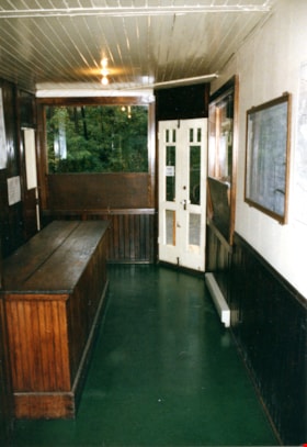
Interior of land surveyor's office at Burnaby Village Museum
https://search.heritageburnaby.ca/link/museumdescription13768
- Repository
- Burnaby Village Museum
- Date
- Sept. 1987
- Collection/Fonds
- Century Park Museum Association fonds
- Description Level
- Item
- Physical Description
- 1 photograph : col. ; 9 x 12.5 cm
- Scope and Content
- Photograph of the interior of the land surveyor's office at Burnaby Village Museum. Office is furnished with a roll top desk, maps and plans and various surveying tools.
- Repository
- Burnaby Village Museum
- Collection/Fonds
- Century Park Museum Association fonds
- Description Level
- Item
- Physical Description
- 1 photograph : col. ; 9 x 12.5 cm
- Scope and Content
- Photograph of the interior of the land surveyor's office at Burnaby Village Museum. Office is furnished with a roll top desk, maps and plans and various surveying tools.
- Subjects
- Occupations - Land Surveyors
- Names
- Burnaby Village Museum
- Geographic Access
- Deer Lake Avenue
- Accession Code
- BV020.5.958
- Access Restriction
- No restrictions
- Reproduction Restriction
- No known restrictions
- Date
- Sept. 1987
- Media Type
- Photograph
- Scan Resolution
- 600
- Scan Date
- 22-Sep-2020
- Scale
- 100
- Notes
- Title based on contents of photograph
Images


Land being cleared for Saint Theresa's Roman Catholic Church
https://search.heritageburnaby.ca/link/museumdescription902
- Repository
- Burnaby Village Museum
- Date
- 1929
- Collection/Fonds
- Burnaby Village Museum Photograph collection
- Description Level
- Item
- Physical Description
- 1 photograph : b&w ; 6.7 x 11.4 cm
- Scope and Content
- Photograph of three unidentified men standing on Douglas Road (later renamed in part Canada Way) with Laurel Street in the background on the left and the site of Saint Theresa's Roman Catholic Church as a lot with blackened stumps. The church was located at the southeast corner of Canada Way and L…
- Repository
- Burnaby Village Museum
- Collection/Fonds
- Burnaby Village Museum Photograph collection
- Description Level
- Item
- Physical Description
- 1 photograph : b&w ; 6.7 x 11.4 cm
- Scope and Content
- Photograph of three unidentified men standing on Douglas Road (later renamed in part Canada Way) with Laurel Street in the background on the left and the site of Saint Theresa's Roman Catholic Church as a lot with blackened stumps. The church was located at the southeast corner of Canada Way and Laurel Street. According to an accompanying note located with the photograph, the first church building burned to the ground the night before it was to be blessed. Insurance for the church had been arranged for by Colonel Dorrell only hours before it was burned and even though signatures had not been affixed to the policy, the insurance company honoured the claim. The second building was smaller and had no basement. Father Trainer was the first priest. This church was torn down in 1974 and a new church building was erected across the road on Canada Way.
- Subjects
- Land Clearing
- Geographic Access
- Douglas Road
- Canada Way
- Laurel Street
- Accession Code
- HV975.105.1
- Access Restriction
- No restrictions
- Reproduction Restriction
- No known restrictions
- Date
- 1929
- Media Type
- Photograph
- Historic Neighbourhood
- Burnaby Lake (Historic Neighbourhood)
- Planning Study Area
- Douglas-Gilpin Area
- Scan Resolution
- 600
- Scan Date
- 2023-06-06
- Notes
- Title based on contents of photograph
- Information on the scope and content of the photograph is taken from an acquisition record from the time of the accession
Images

Land Registry document re title no. 4130 K
https://search.heritageburnaby.ca/link/museumdescription18803
- Repository
- Burnaby Village Museum
- Date
- [192-]
- Collection/Fonds
- Love family fonds
- Description Level
- Item
- Physical Description
- 1 p. of textual records
- Scope and Content
- Item consists of a document from the Government of British Columbia Land Registry Office re indefeasible title no. 4130 K signed by Arthur G. Smith, District Registrar of Titles.
- Repository
- Burnaby Village Museum
- Collection/Fonds
- Love family fonds
- Description Level
- Item
- Physical Description
- 1 p. of textual records
- Scope and Content
- Item consists of a document from the Government of British Columbia Land Registry Office re indefeasible title no. 4130 K signed by Arthur G. Smith, District Registrar of Titles.
- Accession Code
- BV992.26.23
- Access Restriction
- No restrictions
- Reproduction Restriction
- No known restrictions
- Date
- [192-]
- Media Type
- Textual Record
- Notes
- Title based on contents of item
- Document, buff paper with blue letterhead and blue carbon typing; B.C. coat of arms at top with motto; "THE GOVERNMENT OF THE PROVINCE OF BRITISH COLUMBIA", then headed "LAND REGISTRY OFFICE, Vancouver, B.C."; "Sir: I have the honour to enclose herewith Certificate of Indefeasible Title No.", and dotted line with "4130 K" in black ink; "Under the Act, all original documents, including your deed, must remain on deposit in this office when registered. Your attention is called to the fact that the enclosed is a valuable document and that you cannot deal with your property without its production. If you desire and return the Certificate it will be kept in this office for you free of charge. Kindly acknowledge receipt. I have the honour to be, Sir, Your obedient servant, "ARTHUR G. SMITH, District Registrar of titles, per" and dotted line with illegible black ink initials; "Registered mail."; at bottom, "Received Certificate of Title No." "4130K" "this", blank line, "day of", blank line, ", 192--"; at bottom, "(Signed)", blank line; at bottom left, "1M-1224-8313"; watermark "PROGRESS BOND" "MADE IN CANADA"
Love and Leonard land records series
https://search.heritageburnaby.ca/link/museumdescription18838
- Repository
- Burnaby Village Museum
- Date
- 1893-1962
- Collection/Fonds
- Love family fonds
- Description Level
- Series
- Physical Description
- 5 plans + 8 cm of textual records
- Scope and Content
- Series consists of land deeds, land sale agreements, documents regarding payment and survey and subdivision plans. Records refer to the Love family property in District Lot 25, the Leonard family property in District Lot 352 and other lots in Burnaby.
- Repository
- Burnaby Village Museum
- Collection/Fonds
- Love family fonds
- Description Level
- Series
- Physical Description
- 5 plans + 8 cm of textual records
- Scope and Content
- Series consists of land deeds, land sale agreements, documents regarding payment and survey and subdivision plans. Records refer to the Love family property in District Lot 25, the Leonard family property in District Lot 352 and other lots in Burnaby.
- Accession Code
- BV992.26
- BV012.31
- Date
- 1893-1962
- Media Type
- Textual Record
- Cartographic Material
- Notes
- Title based on contents of series
Love farmhouse land and tax records
https://search.heritageburnaby.ca/link/museumdescription10022
- Repository
- Burnaby Village Museum
- Date
- 1891-1982 (date of originals), copied [ca.1988]
- Collection/Fonds
- Burnaby Village Museum fonds
- Description Level
- File
- Physical Description
- 1 folder of textual records
- Scope and Content
- File consists of photocopies and notes of historical information regarding the land ownership of the Jesse Love farmhouse and title of Block 1 and Lots 53 and 54 of District Lot 25 in Burnaby. Records include copies from a land title search done through the New Westminster Land Title Office in 1988…
- Repository
- Burnaby Village Museum
- Collection/Fonds
- Burnaby Village Museum fonds
- Series
- Jesse Love farmhouse series
- Subseries
- Love farmhouse research files subseries
- Description Level
- File
- Physical Description
- 1 folder of textual records
- Scope and Content
- File consists of photocopies and notes of historical information regarding the land ownership of the Jesse Love farmhouse and title of Block 1 and Lots 53 and 54 of District Lot 25 in Burnaby. Records include copies from a land title search done through the New Westminster Land Title Office in 1988 which covers ownership between 1928-1988; copy of Corporation of District of Burnaby By-Law 217 (1916) - "To confirm the purchase of and to reconvey a portion of District Lots 25 and 88..." ; copies of pages from Assessment Rolls between 1892 to 1904 ; copy of Land Sale Agreement from J.C Armstrong to Jesse Love, Oct. 6th, 1893; copies of notes from "Charge Book" Feb. 10, 1894 as well as copies of subdivision plans of DL 25.
- Accession Code
- BV018.41.1116
- Access Restriction
- Subject to FIPPA
- Reproduction Restriction
- Reproductions subject to FIPPA
- Date
- 1891-1982 (date of originals), copied [ca.1988]
- Media Type
- Textual Record
- Notes
- Title based on content of file
![Inside of the surveyor's office, [198_] thumbnail](/media/hpo/_Data/_BVM_Images/2020/2020_0005_0665_001.jpg?width=280)
Inside of the surveyor's office
https://search.heritageburnaby.ca/link/museumdescription13035
- Repository
- Burnaby Village Museum
- Date
- [198_]
- Collection/Fonds
- Century Park Museum Association fonds
- Description Level
- Item
- Physical Description
- 1 photograph : col. ; 20 x 25 cm
- Scope and Content
- Photograph of the interior of the "Surveyor's Office" inside of the Heritage Village Museum. A long wood table, wood stove, roll top desk, survey plans and surveying equipment are visible.
- Repository
- Burnaby Village Museum
- Collection/Fonds
- Century Park Museum Association fonds
- Description Level
- Item
- Physical Description
- 1 photograph : col. ; 20 x 25 cm
- Scope and Content
- Photograph of the interior of the "Surveyor's Office" inside of the Heritage Village Museum. A long wood table, wood stove, roll top desk, survey plans and surveying equipment are visible.
- Subjects
- Occupations - Land Surveyors
- Names
- Burnaby Village Museum
- Accession Code
- BV020.5.665
- Access Restriction
- No restrictions
- Reproduction Restriction
- No known restrictions
- Date
- [198_]
- Media Type
- Photograph
- Related Material
- See also photograph BV020.5.664
- Scan Resolution
- 600
- Scan Date
- 1-May-20
- Scale
- 100
- Notes
- Title based on contents of photograph
Images
![Inside of the surveyor's office, [198_] thumbnail](/media/hpo/_Data/_BVM_Images/2020/2020_0005_0665_001.jpg)
Interior of real estate office at Burnaby Village Museum
https://search.heritageburnaby.ca/link/museumdescription13773
- Repository
- Burnaby Village Museum
- Date
- Sept. 1987
- Collection/Fonds
- Century Park Museum Association fonds
- Description Level
- Item
- Physical Description
- 1 photograph : col. ; 12.5 x 9 cm
- Scope and Content
- Photograph of the interior of Burnaby Village Museum realestate office.
- Repository
- Burnaby Village Museum
- Collection/Fonds
- Century Park Museum Association fonds
- Description Level
- Item
- Physical Description
- 1 photograph : col. ; 12.5 x 9 cm
- Scope and Content
- Photograph of the interior of Burnaby Village Museum realestate office.
- Subjects
- Occupations - Land Surveyors
- Names
- Burnaby Village Museum
- Geographic Access
- Deer Lake Avenue
- Accession Code
- BV020.5.963
- Access Restriction
- No restrictions
- Reproduction Restriction
- No known restrictions
- Date
- Sept. 1987
- Media Type
- Photograph
- Scan Resolution
- 600
- Scan Date
- 22-Sep-2020
- Scale
- 100
- Notes
- Title based on contents of photograph
Images

![Interior of surveyor's office, [198_] thumbnail](/media/hpo/_Data/_BVM_Images/2020/2020_0005_0838_002.jpg?width=280)
Interior of surveyor's office
https://search.heritageburnaby.ca/link/museumdescription13495
- Repository
- Burnaby Village Museum
- Date
- [198_]
- Collection/Fonds
- Century Park Museum Association fonds
- Description Level
- Item
- Physical Description
- 1 photograph : col. negative ; 5.5 x 5.5 cm
- Scope and Content
- Photograph of the interior of the Land Surveyor's office "Hill & Burnett" inside of Burnaby Village Museum. The exhibit includes a roll top desk, a pendulum wall clock as well as land surveying equipment.
- Repository
- Burnaby Village Museum
- Collection/Fonds
- Century Park Museum Association fonds
- Description Level
- Item
- Physical Description
- 1 photograph : col. negative ; 5.5 x 5.5 cm
- Scope and Content
- Photograph of the interior of the Land Surveyor's office "Hill & Burnett" inside of Burnaby Village Museum. The exhibit includes a roll top desk, a pendulum wall clock as well as land surveying equipment.
- Subjects
- Occupations - Land Surveyors
- Surveying and Navigational Tools and Equipment
- Timekeeping Tools and Equipment
- Names
- Burnaby Village Museum
- Accession Code
- BV020.5.838
- Access Restriction
- No restrictions
- Reproduction Restriction
- No known restrictions
- Date
- [198_]
- Media Type
- Photograph
- Scan Resolution
- 1200
- Scan Date
- 25-Aug-2020
- Scale
- 100
- Notes
- Title based on contents of photograph
- 1 col. print; 8.5 x 9 cm accompanying negative (negative no.4)
Images
![Interior of surveyor's office, [198_] thumbnail](/media/hpo/_Data/_BVM_Images/2020/2020_0005_0838_002.jpg)
Surveyor field book 32
https://search.heritageburnaby.ca/link/museumdescription19633
- Repository
- Burnaby Village Museum
- Date
- 1913-1929, predominant 1913
- Collection/Fonds
- Burnaby Village Museum Map collection
- Description Level
- Item
- Physical Description
- 1 notebook
- Scope and Content
- Item consists of a field notebook with surveyor's field notes created by B.C. Land Surveyor, Walter Wilkie. Field notes include pertinent information, calculations, sketches and observations including geographic areas in Burnaby (D.L.86 and D.L. 136); Surrey (Twp 1, Twp 7); Maple Ridge (Twp 12); La…
- Repository
- Burnaby Village Museum
- Collection/Fonds
- Burnaby Village Museum Map collection
- Description Level
- Item
- Physical Description
- 1 notebook
- Material Details
- Yellow leather hardcover book with inscription on cover "FIELD BOOK";Technical Manufacturing & Supply Co., Vancouver, B.C.
- Annotation in black ink on front cover reads: "32"
- Includes reference tables at front and back of notebook for surveying computations.
- Scope and Content
- Item consists of a field notebook with surveyor's field notes created by B.C. Land Surveyor, Walter Wilkie. Field notes include pertinent information, calculations, sketches and observations including geographic areas in Burnaby (D.L.86 and D.L. 136); Surrey (Twp 1, Twp 7); Maple Ridge (Twp 12); Langley (Twp 10, Twp 11 and Lots 36, 304, 308, 309, 312); Dewdney (D.L. 484 Group 1) and Coquitlam (D.L.366 Group 1). Notebook includes a handwritten index of surveying content, on the last few pages at back of book.
- Creator
- Wilkie, "Walter" Gerald
- Subjects
- Occupations - Land Surveyors
- Accession Code
- HV977.128.1
- Access Restriction
- No restrictions
- Reproduction Restriction
- No known restrictions
- Date
- 1913-1929, predominant 1913
- Media Type
- Textual Record
- Notes
- Title based on contents of item
Application for charge by agreement for sale
https://search.heritageburnaby.ca/link/museumdescription10080
- Repository
- Burnaby Village Museum
- Date
- 1929-1930
- Collection/Fonds
- Love family fonds
- Description Level
- Item
- Physical Description
- 1 p. of textual records
- Scope and Content
- Item consists of "B.C. Land Registry Act / Form C (Section 126)" for application for a charge by agreement (?) on the property of William and Sarah Parker located on Cumberland Road in Burnaby. The description of land is "Part .308 acres of the southerly 12.687 acres of Block 1, of the easterly por…
- Repository
- Burnaby Village Museum
- Collection/Fonds
- Love family fonds
- Description Level
- Item
- Physical Description
- 1 p. of textual records
- Material Details
- "This agreement, made in duplicate this Thirty-first / day of October in the year of Our Lord one thousand nine hundred and twenty eight / Between / George Richard Love . . . . . / AND / WILLIAM MICHAEL PARKER . . ./ And SARA MARIA PARKER . . . " printed and typed on the top of the first page.
- Scope and Content
- Item consists of "B.C. Land Registry Act / Form C (Section 126)" for application for a charge by agreement (?) on the property of William and Sarah Parker located on Cumberland Road in Burnaby. The description of land is "Part .308 acres of the southerly 12.687 acres of Block 1, of the easterly portion of DL 25" between "Parties" George Richard Love to William Michael and Sarah Maria Parker. The application was originally dated August 7, 1929 and was crossed out and replaced with October 8, 1930.
- History
- See extensive history of Love Family and Love farmhouse located at Burnaby Village Museum.
- Accession Code
- BV012.31.12
- Access Restriction
- No restrictions
- Reproduction Restriction
- No known restrictions
- Date
- 1929-1930
- Media Type
- Textual Record
- Notes
- Title based on content of file
Certificate of encumbrance
https://search.heritageburnaby.ca/link/museumdescription10070
- Repository
- Burnaby Village Museum
- Date
- 1925
- Collection/Fonds
- Love family fonds
- Description Level
- Item
- Physical Description
- 1 p. of textual records
- Scope and Content
- Item consists of CERTIFICATE OF ENCUMBRANCE / #25320 Land Registry Office / New Westminster, B.C. / 30 minutes past 10 o'clock 10th day of March 1925" regarding the title to"Lot 56 of Lot 7, Suburban Block 1, Map 2620 in the City of New Westminster" with the "Registered Owner : Jesse Love" to mortg…
- Repository
- Burnaby Village Museum
- Collection/Fonds
- Love family fonds
- Description Level
- Item
- Physical Description
- 1 p. of textual records
- Scope and Content
- Item consists of CERTIFICATE OF ENCUMBRANCE / #25320 Land Registry Office / New Westminster, B.C. / 30 minutes past 10 o'clock 10th day of March 1925" regarding the title to"Lot 56 of Lot 7, Suburban Block 1, Map 2620 in the City of New Westminster" with the "Registered Owner : Jesse Love" to mortgage said property to John Whiting.
- History
- See extensive history of Love Family and Love farmhouse located at Burnaby Village Museum.
- Accession Code
- BV012.31.2
- Access Restriction
- No restrictions
- Reproduction Restriction
- No known restrictions
- Date
- 1925
- Media Type
- Textual Record
- Notes
- Title based on content of file
Certificate of indefeasible title
https://search.heritageburnaby.ca/link/museumdescription10077
- Repository
- Burnaby Village Museum
- Date
- 1928
- Collection/Fonds
- Love family fonds
- Description Level
- Item
- Physical Description
- 1 p. of textual records
- Scope and Content
- Item consists of a "Certificate of Indeasible Title" transferring title to property in South Vancouver (Lots 11 and 12 of Lots 9 to 13, Block 16, District Lot 352, Group One, New Westminster District / Plan 1344) to the children of Jesse Love. The application was registered August 1, 1928 and signe…
- Repository
- Burnaby Village Museum
- Collection/Fonds
- Love family fonds
- Description Level
- Item
- Physical Description
- 1 p. of textual records
- Material Details
- "From Certificate No. 35010 No 48502 / Certificate of Indefeasible Title / Date of Application for registration the 1st day of August, 1928 / Register, Vol. 559" printed and hand written at top of main page of document.
- Scope and Content
- Item consists of a "Certificate of Indeasible Title" transferring title to property in South Vancouver (Lots 11 and 12 of Lots 9 to 13, Block 16, District Lot 352, Group One, New Westminster District / Plan 1344) to the children of Jesse Love. The application was registered August 1, 1928 and signed and witnessed and sealed on August 2, 1928. The reverse side of the ledger page document is titled "Charges, Liens and Interests"
- History
- See extensive history of Love Family and Love farmhouse located at Burnaby Village Museum.
- Accession Code
- BV012.31.9
- Access Restriction
- No restrictions
- Reproduction Restriction
- No known restrictions
- Date
- 1928
- Media Type
- Textual Record
- Notes
- Title based on content of file

Pioneer tales of Burnaby
https://search.heritageburnaby.ca/link/museumlibrary5860
- Repository
- Burnaby Village Museum
- Publication Date
- c1987
- Call Number
- 971.133 SON COPY 4
at Second Street school in 1928. Teacher, not pictured, was Miss Evans.
George Leaf
T
he incorporation of Burnaby as a municipality was still a good four years i n the future w h e n the
Burgess family arrived i n Canada from England i n 1888, staying temporarily i n N e w Westminster a n d
b u y i n g land
- Repository
- Burnaby Village Museum
- Collection
- Digital Reference Collection
- Reference Collection
- Material Type
- Book
- ISBN
- 096928280x
- Call Number
- 971.133 SON COPY 4
- Contributor
- Sone, Michael
- Place of Publication
- Burnaby, B.C.
- Publisher
- Corporation of the District of Burnaby
- Publication Date
- c1987
- Physical Description
- 495 p. : ill. ; 31 cm.
- Inscription
- "TR687 - Bryburgh" / handprinted in pencil on frontend page
- Library Subject (LOC)
- Pioneers--British Columbia--Burnaby
- Frontier and pioneer life
- Biography
- Object History
- Early Burnaby as recalled by the settlers themselves who arrived from every corner of the world between 1888 and 1930, some witnessing incorporation of the district in 1892, all seeking a better life for themselves and especially for their children, all helping transform the wilderness into the modern municipality of today.
- Notes
- "Editor Michael Sone".
- Includes index.
- 4 copies held: copy 4
Images

Digital Books
William Holmes fonds
https://search.heritageburnaby.ca/link/museumdescription10416
- Repository
- Burnaby Village Museum
- Date
- [1841]-1994
- Collection/Fonds
- William Holmes fonds
- Description Level
- Fonds
- Physical Description
- 2 photographs (calotype) + 1 photograph : b&w + 6 photographs : col. + 5 p. textual records + 1 newspaper clipping
- Scope and Content
- Fonds consists of photographs pertaining to the William Holmes family, family grave markers in cemetery in Ireland along with original correspondence, land title certificates and a newspaper clipping. Fonds is arranged in series: 1) William Holmes family photographs series 2) William Holmes family…
- Repository
- Burnaby Village Museum
- Collection/Fonds
- William Holmes fonds
- Description Level
- Fonds
- Physical Description
- 2 photographs (calotype) + 1 photograph : b&w + 6 photographs : col. + 5 p. textual records + 1 newspaper clipping
- Scope and Content
- Fonds consists of photographs pertaining to the William Holmes family, family grave markers in cemetery in Ireland along with original correspondence, land title certificates and a newspaper clipping. Fonds is arranged in series: 1) William Holmes family photographs series 2) William Holmes family records series 3) Holmes family cemetery photographs series
- History
- William Holmes was the first non-Indigenous resident of Burnaby and was born in Kilkenny Ireland January 4, 1812. In 1833, at the age of 20 yrs, William Holmes immigrated to Canada from Ireland in with his parents, Joseph and Jane (McCullough) Holmes and ten other family members including two of his married brothers and their wives, two sisters with their husbands and two unmarried brothers. This was the first group of thirteen to leave Ireland and set up homesteads in Canada near the shores of Lake Huron. The family settled on land concessions in Huron County, Ontario about 14 km southeast of Goderich. The area in Huron County was first founded in 1832 by John and Samuel Holmes and the community was known as Holmes Hill before becoming Holmesville [ca. 1850]. In 1837, William Holmes is noted as owning Lot 23, Concession IX, Goderich Twp. Much of the village of Holmesville grew up around the five road concession near the border of his brother’s farm so William decided to open a store. The Holmesville post office opened on March 1, 1855 and William was appointed the first post master which he operated until May 1857. William met and married Mary Richardson in 1841 and the couple had three daughters: Jane (1844-1926) (married Charles Studdert Finlaison in New Westminster in 1863); Anne Maria (Annie) (1846-192?) (married John Gunther Jennings in New Westminster in 1865 and married Robert Johnson in New Westminster in 1877) and Elizabeth (1848-1934) (married Thomas Carrington of Lakes District in 1867). William’s wife, Mary (Richardson) Holmes died in Holmesville sometime between 1848 and 1853. Following the death of his first wife, Mary, William married Charlotte McCullough (McCulloch). The couple had four daughters; Arabella Charlotte Amelia (1854-1943) (married Arthur Robert Green in 1887); Laura (1855-1867); Arabella Henrietta (1857-1929) (married Clark Wesley Gillanders in 1880) and Mary (1863-1864). During the late 1850s, William became aware of the gold rush and opportunities opening up in British Columbia so left for the west coast in 1858 at the age of 46 yrs. In preparation for his move to the west coast of Canada, William obtained a letter of introduction from top government officials of Canada. William Holmes arrived in British Columbia in 1859. Upon arriving, he first worked running pack trains from Harrison Mills to Lillooet. After earning some money, he decided to re-invest it in land. His first pre-emption of land occurred on January 21, 1860 for 160 acres situated on North Road from the Military Camp to Burrard Inlet and distancing 25 chains south of the Brunette River and 20 chains south of the river with the land extending in a westerly direction. On March 17, 1860, Holmes received a Crown Grant for this and other land in the immediate area totalling 415 acres of which was known as Lot No. 1, Group 1, Rural Land, New Westminster District. The balance of land was situated on the east side of the Brunette River – Lot 13, with 344 2/3 acres of which he made an application to purchase on June 26, 1860, and a Crown Grant dated March 16, 1861 covering 86 acres. Holmes also pre-empted land in Port Moody and Pitt Meadows in 1860 and 1861. The name of “Brunette River” is officially attributed to William Holmes who referred to the river as “Brunette” due to it’s dark colour originating from the peat lands above the lake. Following his purchase of property, he sent for his wife Charlotte, their three daughters and her three step daughters (from William’s first marriage). Charlotte and the six children made the long trip to B.C. by ship and rail, crossing the Isthmus of Darien at Panama. They arrived in B.C. in October 1861 and moved into a one room log cabin built by William. The cabin stood on the North Road at the foot of Sapperton, on a bluff overlooking the Brunette River. Eventually the family moved to a larger dwelling but the original cabin remained on the site until the 1890s when it was burned after being used as a sick house. Mr. Holmes was instrumental in organizing the first Orange Lodge in British Columbia. He was a prominent Orangeman who joined the order in 1840 and was the first master in the order of the City of New Westminster when the Lodge No. 1150 was established there. Charlotte Holmes died in New Westminster in 1893 at the age of 70 years and William Holmes died in New Westminster September 11, 1907 at the age of 95 years.
- Responsibility
- Holmes, William
- Accession Code
- HV971.46
- BV997.50
- Date
- [1841]-1994
- Media Type
- Photograph
- Textual Record
- Related Material
- See also: Reference file: Persons - Holmes, William
- Notes
- Title based on contents of fonds
Ronald G. Scobbie collection
https://search.heritageburnaby.ca/link/museumdescription11914
- Repository
- Burnaby Village Museum
- Date
- [1890]-1932
- Collection/Fonds
- Ronald G. Scobbie collection
- Description Level
- Fonds
- Physical Description
- 55 plans + 2 architectural drawings + 1 map + graphic materials + 3 cm of textual records
- Scope and Content
- Fonds consists of survey and subdivision plans, a map and records created by Provincial Land Surveyors Albert J. Hill and Geoffrey K. Burnett and Donald Johnson McGugan and collected by Ronald G. Scobbie. Records include subdivision and survey plans in New Westminster District Group 1 including Dis…
- Repository
- Burnaby Village Museum
- Collection/Fonds
- Ronald G. Scobbie collection
- Description Level
- Fonds
- Physical Description
- 55 plans + 2 architectural drawings + 1 map + graphic materials + 3 cm of textual records
- Scope and Content
- Fonds consists of survey and subdivision plans, a map and records created by Provincial Land Surveyors Albert J. Hill and Geoffrey K. Burnett and Donald Johnson McGugan and collected by Ronald G. Scobbie. Records include subdivision and survey plans in New Westminster District Group 1 including District Lots in Burnaby along with various school sites and church plans; surveying records regarding North Road and a map of the Burnaby Municipality. Fonds is arranged into series: 1) Subdivision and survey plans series 2) School and church plans series 3) Map series
- History
- Ronald G. Scobbie was born in Scotland. After graduating from high school, he worked in the mines of Scotland which led to a career as a land surveyor. Ron immigrated to Canada in 1965 and settled in North Vancouver. In 1967 he became a partner in the surveying company of Hunter, Crockford & Scobbie in New Westminster, eventually owning it under the title Scobbie and Associates between 1980 and 1995. Ron sold the business in 1995 and retired as a BC Land Surveyor in December 2003. Ron was an active member of the B.C. Land Surveyors Association and an avid collector of surveying equipment and maps and plans that document the history of surveying in British Columbia. Upon retirement, Ron donated many historical maps and plans to various repositories located in different geographical regions throughout B.C.
- Scobbie & Associates land surveying company dates back to 1890 when Albert J. Hill first established his practice as a land surveyor in New Westminster. The company went through a series of Surveyors (owners) between 1890 and 1995:
- Albert James Hill (A.J. Hill) [1890] to 1912
- Hill & Burnett 1911 to 1912
- Geoffrey K. Burnett 1912
- Burnett & McGugan 1912 to 1947
- Burnett, McGugan & Hunter 1947 to 1959
- Burnett, Hunter & Douglas 1959 to 1960
- Hunter, Douglas & Crockford 1960 to 1964
- Hunter, Crockford & Associates 1964 to 1965
- Hunter, Crockford & Aplin 1965 to 1967
- Hunter, Crockford & Scobbie 1967 to 1973
- Crockford, Scobbie & Associates 1973-1980
- Scobbie & Associates 1980 to 1995
- Responsibility
- Scobbie, Ronald G.
- Accession Code
- HV984.57
- BV003.83
- Access Restriction
- No restrictions
- Reproduction Restriction
- No known restrictions
- Date
- [1890]-1932
- Related Material
- For other survey and subdivision plans created by land surveyors Albert J. Hill, Geoffery K. Burnett and Donald J. McGugan, see: Burnaby Village Museum Map collection - Survey and Subdivision plans series
- Notes
- Title based on contents of collection