Narrow Results By
Subject
- Advertising Medium 1
- Aerial Photographs 38
- Agriculture - Farms 1
- Animals - Dogs 1
- Animals - Fish 1
- Arts - Sculptures 2
- Buildings - Commercial - Hotels and Motels 1
- Buildings - Commercial - Train Stations 5
- Buildings - Residential - Houses 2
- Buildings - Schools - Universities and Colleges 2
- Clothing - Uniforms 1
- Construction - Road Construction 1
![British Columbia Electric Railway Company timetables, [between 1946 and 1973] thumbnail](/media/hpo/_Data/_BVM_Images/1973/1973_0041_0005_001.jpg?width=280)
British Columbia Electric Railway Company timetables
https://search.heritageburnaby.ca/link/museumdescription996
- Repository
- Burnaby Village Museum
- Date
- [between 1946 and 1973]
- Collection/Fonds
- Burnaby Village Museum Photograph collection
- Description Level
- Item
- Physical Description
- 1 photograph : b&w ; 20.4 x 25.3 cm
- Scope and Content
- Photograph of a BC Electric Railway timetable for the Lulu Island Branch, Eburne, and New Westminster Line, including a Sunday schedule and freight schedule.
- Repository
- Burnaby Village Museum
- Collection/Fonds
- Burnaby Village Museum Photograph collection
- Description Level
- Item
- Physical Description
- 1 photograph : b&w ; 20.4 x 25.3 cm
- Scope and Content
- Photograph of a BC Electric Railway timetable for the Lulu Island Branch, Eburne, and New Westminster Line, including a Sunday schedule and freight schedule.
- Accession Code
- HV973.41.5
- Access Restriction
- No restrictions
- Reproduction Restriction
- May be restricted by third party rights
- Date
- [between 1946 and 1973]
- Media Type
- Photograph
- Related Material
- For an earlier donation made by the same donor in regards to BCER tram, see accession HV972.202.
- Scan Resolution
- 300
- Scan Date
- 2023-05-16
- Notes
- Title based on contents of photograph
Images
![British Columbia Electric Railway Company timetables, [between 1946 and 1973] thumbnail](/media/hpo/_Data/_BVM_Images/1973/1973_0041_0005_001.jpg)
![British Columbia Electric Railway Company timetables, [between 1946 and 1973] thumbnail](/media/hpo/_Data/_BVM_Images/1973/1973_0041_0006_001.jpg?width=280)
British Columbia Electric Railway Company timetables
https://search.heritageburnaby.ca/link/museumdescription997
- Repository
- Burnaby Village Museum
- Date
- [between 1946 and 1973]
- Collection/Fonds
- Burnaby Village Museum Photograph collection
- Description Level
- Item
- Physical Description
- 1 photograph : b&w ; 25.4 x 20.6 cm
- Scope and Content
- Photograph of two British Columbia Electric Railway Company timetables for the Central Park line, one "corrected to October 15, 1933" and the other "corrected to May 16, 1946." Also in the photograph are two tickets, one reads, "Good for one fare at 10 for $1.25 between Vancouver and Burnaby North…
- Repository
- Burnaby Village Museum
- Collection/Fonds
- Burnaby Village Museum Photograph collection
- Description Level
- Item
- Physical Description
- 1 photograph : b&w ; 25.4 x 20.6 cm
- Scope and Content
- Photograph of two British Columbia Electric Railway Company timetables for the Central Park line, one "corrected to October 15, 1933" and the other "corrected to May 16, 1946." Also in the photograph are two tickets, one reads, "Good for one fare at 10 for $1.25 between Vancouver and Burnaby Northwest Zone" and the other reads, "Good for one fare between Vancouver and Park Ave."
- Accession Code
- HV973.41.6
- Access Restriction
- No restrictions
- Reproduction Restriction
- May be restricted by third party rights
- Date
- [between 1946 and 1973]
- Media Type
- Photograph
- Related Material
- For an earlier donation made by the same donor in regards to BCER tram, see accession HV972.202.
- Scan Resolution
- 300
- Scan Date
- 2023-05-16
- Notes
- Title based on contents of photograph
Images
![British Columbia Electric Railway Company timetables, [between 1946 and 1973] thumbnail](/media/hpo/_Data/_BVM_Images/1973/1973_0041_0006_001.jpg)
![British Columbia Institute of Technology campus, [1964] published February 5, 1964 thumbnail](/media/hpo/_Data/_Archives_Images/_Unrestricted/480/480-332.jpg?width=280)
British Columbia Institute of Technology campus
https://search.heritageburnaby.ca/link/archivedescription45437
- Repository
- City of Burnaby Archives
- Date
- [1964] published February 5, 1964
- Collection/Fonds
- Columbian Newspaper collection
- Description Level
- Item
- Physical Description
- 1 photograph : b&w ; 7.5 x 23 cm
- Scope and Content
- Photograph of the British Columbia Institute of Technology campus.
- Repository
- City of Burnaby Archives
- Date
- [1964] published February 5, 1964
- Collection/Fonds
- Columbian Newspaper collection
- Physical Description
- 1 photograph : b&w ; 7.5 x 23 cm
- Description Level
- Item
- Record No.
- 480-332
- Access Restriction
- No restrictions
- Reproduction Restriction
- No restrictions
- Accession Number
- 2003-02
- Scope and Content
- Photograph of the British Columbia Institute of Technology campus.
- Media Type
- Photograph
- Photographer
- King, Basil
- Notes
- Title based on contents of photograph
- Geographic Access
- Willingdon Avenue
- Street Address
- 3700 Willingdon Avenue
- Historic Neighbourhood
- Burnaby Lake (Historic Neighbourhood)
- Planning Study Area
- Douglas-Gilpin Area
Images
![British Columbia Institute of Technology campus, [1964] published February 5, 1964 thumbnail](/media/hpo/_Data/_Archives_Images/_Unrestricted/480/480-332.jpg)
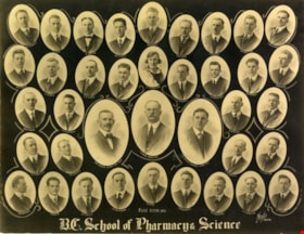
![British Columbia School of Pharmacy and Science, [1920] thumbnail](/media/hpo/_Data/_BVM_Images/1985/198800680003.jpg?width=280)
British Columbia School of Pharmacy and Science
https://search.heritageburnaby.ca/link/museumdescription112
- Repository
- Burnaby Village Museum
- Date
- [1920]
- Collection/Fonds
- Burnaby Village Museum Photograph collection
- Description Level
- Item
- Physical Description
- 1 photograph : sepia composite ; 26.5 x 34 cm
- Scope and Content
- Composite photograph of students of the British Columbia School of Pharmacy and Science. Names are listed beneath each of the oval photographs (grouped in four rows). In the top row (from left) are; F. McIntosh "Mat. Med + Botany", O.P. Harrison, H.E. Falk, I.M. Wilson, E.G. McDonagh, G.H. Goodard,…
- Repository
- Burnaby Village Museum
- Collection/Fonds
- Burnaby Village Museum Photograph collection
- Description Level
- Item
- Physical Description
- 1 photograph : sepia composite ; 26.5 x 34 cm
- Scope and Content
- Composite photograph of students of the British Columbia School of Pharmacy and Science. Names are listed beneath each of the oval photographs (grouped in four rows). In the top row (from left) are; F. McIntosh "Mat. Med + Botany", O.P. Harrison, H.E. Falk, I.M. Wilson, E.G. McDonagh, G.H. Goodard, P.J. Bain "Principal". Second row; A. McLennan, C.C. Denny, W.G. Smith, L.P. Landry, E.J. Harrison, B.M. Adams, H.D. Hipwell, and A.W. Barr. Third row; H.L. Fee, C.D. Houghland, A.R. Bush, R.W. Smith, W. James, B.A. McKeown, W.K. Corning, S.R. Davies and G.W.H. Stearman. Bottom row; G. Baillie "Pharmacy + Physics", A.H. Blumenauer, D.J. Bailey, J.Q. Adams, G.P. Doran and S. Foulds "Chemistry".
- Subjects
- Occupations - Teachers
- Names
- British Columbia School of Pharmacy and Science
- McIntosh, F.
- Harrison, O. P.
- Falk, H. E.
- Wilson, I. M.
- McDonagh, E. G.
- Goodard, G. H.
- Bain, P. J.
- McLennan, A.
- Denny, C. C.
- Smith, W.G.
- Landry, L. P.
- Harrison, E. J.
- Adams, B. M.
- Hipwell, H. D.
- Barr, A.W.
- Fee, H. L.
- Houghland, C. D.
- Bush, A. R.
- Smith, R.W.
- James, W.
- McKeown, B. A.
- Corning, W. K.
- Davies, S. R.
- Stearman, G. W. H.
- Baillie, G.
- Blumenauer, A. H.
- Bailey, D. J.
- Adams, J. Q.
- Doran, G. P.
- Foulds, S.
- Henderson, Gibb Gilmour
- University of British Columbia
- Accession Code
- BV988.68.3
- Access Restriction
- No restrictions
- Reproduction Restriction
- No known restrictions
- Date
- [1920]
- Media Type
- Photograph
- Scan Resolution
- 600
- Scan Date
- 1/11/2010
- Scale
- 100
- Photographer
- Weeks, Arthur Benson
- Notes
- Title based on contents of photograph
- Continuation of title: "... - Second Term 1920"
Images
![British Columbia School of Pharmacy and Science, [1920] thumbnail](/media/hpo/_Data/_BVM_Images/1985/198800680003.jpg)
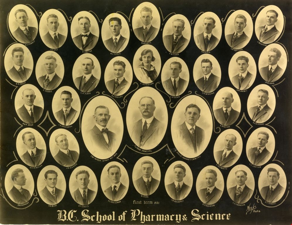
British Columbia School of Pharmacy and Science
https://search.heritageburnaby.ca/link/museumdescription113
- Repository
- Burnaby Village Museum
- Date
- 1921
- Collection/Fonds
- Burnaby Village Museum Photograph collection
- Description Level
- Item
- Physical Description
- 1 photograph : sepia composite ; 26.5 x 34 cm
- Scope and Content
- Composite photograph of students of the British Columbia School of Pharmacy and Science. Names are listed beneath each of the oval photographs (grouped in five rows). In the top row (from left) are; C.S. Forrest, J.G. Saul, S. Smythe, W.A. Speck, G.E. Curtis, C.N. Clark, A.O. Blain, J.D. Witham and…
- Repository
- Burnaby Village Museum
- Collection/Fonds
- Burnaby Village Museum Photograph collection
- Description Level
- Item
- Physical Description
- 1 photograph : sepia composite ; 26.5 x 34 cm
- Scope and Content
- Composite photograph of students of the British Columbia School of Pharmacy and Science. Names are listed beneath each of the oval photographs (grouped in five rows). In the top row (from left) are; C.S. Forrest, J.G. Saul, S. Smythe, W.A. Speck, G.E. Curtis, C.N. Clark, A.O. Blain, J.D. Witham and J. Beddows. In the second row are; G.H. Kelly, R. Rennie, L.A. Pineo, D.J. Bailey, C. Hutchinson, L.A. Blain, B.A. McKeown, G.M. Harvey and A.W. Barr. In the third row are; R.V.R. Hood, J. R. Bradwell, G. Donovan and R. Cochrane. In the centre (in larger ovals) are; F. McIntosh "Mat. Med + Botany", P. J. Bain "Principal" and G. Baillie "Pharmacy + Physics." In the fourth row are; W.R. Hewitson, J.H. Sclater, L. Heyworth and L.C. Simpson. In the bottom row are; A.W. Kennedy, A.R. Bush, S.T. Chess, A. Cheeseman, W. Jude, J.B. Rountree, H.D. Robinson, L.B. Thompson and K.T. Stewart.
- Subjects
- Occupations - Teachers
- Names
- British Columbia School of Pharmacy and Science
- Forrest, C.S.
- Saul, J.G.
- Smythe, S.
- Speck, W.A.
- Curtis, G.E.
- Clark, C.N.
- Blain, A.O.
- Witham, J.D.
- Beddows, J.
- Kelly, G.H.
- Rennie, R.
- Pineo, L.A..
- Bailey, D. J.
- Hutchinson, C.
- Blain, L.A.
- McKeown, B. A.
- Harvey, G.M.
- Barr, A.W.
- Hood, R.V.R.
- Bradwell, J.R.
- Donovan, G.
- Cochrane, R.
- McIntosh, F.
- Bain, P. J.
- Baillie, G.
- Hewitson, W.R.
- Sclater, J.H.
- Heyworth, L.
- Simpson, L.C.
- Kennedy, A.W.
- Bush, A. R.
- Chess, S.T.
- Cheeseman, A.
- Jude, W.
- Rountree, J.B.
- Robinson, H.D.
- Thompson, L.B.
- Stewart, K.T.
- Henderson, Gibb Gilmour
- University of British Columbia
- Accession Code
- BV988.68.4
- Access Restriction
- No restrictions
- Reproduction Restriction
- No known restrictions
- Date
- 1921
- Media Type
- Photograph
- Scan Resolution
- 600
- Scan Date
- 1/8/2010
- Scale
- 100
- Photographer
- Weeks, Arthur Benson
- Notes
- Continuation of title: "... first term 1921"
Images
![Image of British Columbia Music Festival Certificate, [1926] (date of original), copied [2016] thumbnail](/media/hpo/_Data/_BVM_Images/2016/201600430009_001.jpg?width=280)
Image of British Columbia Music Festival Certificate
https://search.heritageburnaby.ca/link/museumdescription4108
- Repository
- Burnaby Village Museum
- Date
- [1926] (date of original), copied [2016]
- Collection/Fonds
- Esther Love Stanley fonds
- Description Level
- Item
- Physical Description
- 1 photograph (tiff)
- Scope and Content
- Copy scan of a certificate from the British Columbia Musical Festival. "This is to Certify that The Vancouver Scottish Orchestra / (Conductor, Thomas Shankie) / has been awarded First place in the competition for / Orchestras - Open - Holding the 'Gold Range' Challenge / Cup for 1926 / in the Briti…
- Repository
- Burnaby Village Museum
- Collection/Fonds
- Esther Love Stanley fonds
- Description Level
- Item
- Physical Description
- 1 photograph (tiff)
- Scope and Content
- Copy scan of a certificate from the British Columbia Musical Festival. "This is to Certify that The Vancouver Scottish Orchestra / (Conductor, Thomas Shankie) / has been awarded First place in the competition for / Orchestras - Open - Holding the 'Gold Range' Challenge / Cup for 1926 / in the British Columbia Musical Competition Festival, 1926."
- Subjects
- Documentary Artifacts - Certificates
- Accession Code
- BV016.43.9
- Access Restriction
- No restrictions
- Reproduction Restriction
- May be restricted by third party rights
- Date
- [1926] (date of original), copied [2016]
- Media Type
- Photograph
- Notes
- Title based on contents of photograph.
- Image is from a binder of family history. Binder 1, orange cover "Old Stanley Family Photo / Old Shankie Family Photos / War Photos - Echo Photos".
- Digital image created from orginal photograph by donor
Images
![Image of British Columbia Music Festival Certificate, [1926] (date of original), copied [2016] thumbnail](/media/hpo/_Data/_BVM_Images/2016/201600430009_001.jpg)
![The Lions from Burnaby Park, [between 1926 and 1929] thumbnail](/media/hpo/_Data/_BVM_Images/1971/197202040003.jpg?width=280)
The Lions from Burnaby Park
https://search.heritageburnaby.ca/link/museumdescription3109
- Repository
- Burnaby Village Museum
- Date
- [between 1926 and 1929]
- Collection/Fonds
- Burnaby Village Museum Photograph collection
- Description Level
- Item
- Physical Description
- 1 photograph : b&w photogravure ; 14.5 x 9.5 cm
- Scope and Content
- Photograph of the north shore mountains, including the Lions, taken from Robert Burnaby Park.
- Repository
- Burnaby Village Museum
- Collection/Fonds
- Burnaby Village Museum Photograph collection
- Description Level
- Item
- Physical Description
- 1 photograph : b&w photogravure ; 14.5 x 9.5 cm
- Scope and Content
- Photograph of the north shore mountains, including the Lions, taken from Robert Burnaby Park.
- Geographic Access
- Wedgewood Street
- Robert Burnaby Park
- Street Address
- 8155 Wedgewood Street
- Accession Code
- HV972.204.3
- Access Restriction
- No restrictions
- Reproduction Restriction
- No known restrictions
- Date
- [between 1926 and 1929]
- Media Type
- Photograph
- Historic Neighbourhood
- Burnaby Lake (Historic Neighbourhood)
- Planning Study Area
- Lakeview-Mayfield Area
- Related Material
- For other photographs from the same album, see HV972.204.3 - .14
- Scan Resolution
- 600
- Scan Date
- 2023-04-25
- Photographer
- Lloyd, Frank Ernest
- Notes
- Annotations made in white paint on recto of photograph read: "'The Lions' from Burnaby Park" and "Lloyd Studio, McKay."
Images
![The Lions from Burnaby Park, [between 1926 and 1929] thumbnail](/media/hpo/_Data/_BVM_Images/1971/197202040003.jpg)
Aerial photograph of Burnaby
https://search.heritageburnaby.ca/link/archivedescription84891
- Repository
- City of Burnaby Archives
- Date
- 1963
- Collection/Fonds
- Allan Amundsen collection
- Description Level
- Item
- Physical Description
- 1 photograph : b&w ; 22.5 x 22.5 cm
- Scope and Content
- Aerial photograph of Burnaby north of Lougheed Highway.
- Repository
- City of Burnaby Archives
- Date
- 1963
- Collection/Fonds
- Allan Amundsen collection
- Physical Description
- 1 photograph : b&w ; 22.5 x 22.5 cm
- Description Level
- Item
- Record No.
- 561-012
- Access Restriction
- In Archives only
- Reproduction Restriction
- No reproduction permitted
- Accession Number
- 2014-08
- Scope and Content
- Aerial photograph of Burnaby north of Lougheed Highway.
- Media Type
- Photograph
- Photographer
- Province of British Columbia
- Notes
- Title based on contents of photograph
- This photo is indentified as BC5061:117 and connects with B.C. air photograph BC5061:118 to the east
- Historic Neighbourhood
- Burnaby Lake (Historic Neighbourhood)
- Planning Study Area
- Parkcrest-Aubrey Area
- Ardingley-Sprott Area
Aerial photograph of Burnaby
https://search.heritageburnaby.ca/link/archivedescription84892
- Repository
- City of Burnaby Archives
- Date
- 1963
- Collection/Fonds
- Allan Amundsen collection
- Description Level
- Item
- Physical Description
- 1 photograph : b&w ; 22.5 x 22.5 cm
- Scope and Content
- Aerial photograph of Burnaby north of Lougheed Highway.
- Repository
- City of Burnaby Archives
- Date
- 1963
- Collection/Fonds
- Allan Amundsen collection
- Physical Description
- 1 photograph : b&w ; 22.5 x 22.5 cm
- Description Level
- Item
- Record No.
- 561-013
- Access Restriction
- In Archives only
- Reproduction Restriction
- No reproduction permitted
- Accession Number
- 2014-08
- Scope and Content
- Aerial photograph of Burnaby north of Lougheed Highway.
- Subjects
- Aerial Photographs
- Media Type
- Photograph
- Photographer
- Province of British Columbia
- Notes
- Title based on contents of photograph
- This photo is indentified as BC5061:118 and connects with B.C. air photograph BC5061:117 to the west and BC5061:119 to the east
- Historic Neighbourhood
- Burnaby Lake (Historic Neighbourhood)
- Lozells (Historic Neighbourhood)
- Planning Study Area
- Parkcrest-Aubrey Area
- Ardingley-Sprott Area
- Sperling-Broadway Area
- Government Road Area
Aerial photograph of Burnaby
https://search.heritageburnaby.ca/link/archivedescription84893
- Repository
- City of Burnaby Archives
- Date
- 1963
- Collection/Fonds
- Allan Amundsen collection
- Description Level
- Item
- Physical Description
- 1 photograph : b&w ; 22.5 x 22.5 cm
- Scope and Content
- Aerial photograph of Burnaby north of Lougheed Highway and west of Sperling Avenue.
- Repository
- City of Burnaby Archives
- Date
- 1963
- Collection/Fonds
- Allan Amundsen collection
- Physical Description
- 1 photograph : b&w ; 22.5 x 22.5 cm
- Description Level
- Item
- Record No.
- 561-014
- Access Restriction
- In Archives only
- Reproduction Restriction
- No reproduction permitted
- Accession Number
- 2014-08
- Scope and Content
- Aerial photograph of Burnaby north of Lougheed Highway and west of Sperling Avenue.
- Subjects
- Aerial Photographs
- Media Type
- Photograph
- Photographer
- Province of British Columbia
- Notes
- Title based on contents of photograph
- This photo is indentified as BC5061:119 and connects with B.C. air photograph BC5061:118 to the west and BC5061:120 to the east
- Geographic Access
- Burnaby Mountain Conservation Area
- Historic Neighbourhood
- Lozells (Historic Neighbourhood)
- Planning Study Area
- Sperling-Broadway Area
- Lake City Area
- Government Road Area
Aerial photograph of Burnaby
https://search.heritageburnaby.ca/link/archivedescription84894
- Repository
- City of Burnaby Archives
- Date
- 1963
- Collection/Fonds
- Allan Amundsen collection
- Description Level
- Item
- Physical Description
- 1 photograph : b&w ; 22.5 x 22.5 cm
- Scope and Content
- Aerial photograph of Burnaby north of Broadway and west of Sperling Avenue.
- Repository
- City of Burnaby Archives
- Date
- 1963
- Collection/Fonds
- Allan Amundsen collection
- Physical Description
- 1 photograph : b&w ; 22.5 x 22.5 cm
- Description Level
- Item
- Record No.
- 561-015
- Access Restriction
- In Archives only
- Reproduction Restriction
- No reproduction permitted
- Accession Number
- 2014-08
- Scope and Content
- Aerial photograph of Burnaby north of Broadway and west of Sperling Avenue.
- Subjects
- Aerial Photographs
- Media Type
- Photograph
- Photographer
- Province of British Columbia
- Notes
- Title based on contents of photograph
- This photo is indentified as BC5061:120 and connects with B.C. air photograph BC5061:119 to the west and BC5061:121 to the east
- Geographic Access
- Burnaby Mountain Conservation Area
- Historic Neighbourhood
- Lozells (Historic Neighbourhood)
- Planning Study Area
- Sperling-Broadway Area
- Lake City Area
- Government Road Area
- Burnaby Mountain Area
Aerial photograph of Burnaby
https://search.heritageburnaby.ca/link/archivedescription84896
- Repository
- City of Burnaby Archives
- Date
- 1963
- Collection/Fonds
- Allan Amundsen collection
- Description Level
- Item
- Physical Description
- 1 photograph : b&w ; 22.5 x 22.5 cm
- Scope and Content
- Aerial photograph of Burnaby north of Broadway and west of Sperling Avenue.
- Repository
- City of Burnaby Archives
- Date
- 1963
- Collection/Fonds
- Allan Amundsen collection
- Physical Description
- 1 photograph : b&w ; 22.5 x 22.5 cm
- Description Level
- Item
- Record No.
- 561-016
- Access Restriction
- In Archives only
- Reproduction Restriction
- No reproduction permitted
- Accession Number
- 2014-08
- Scope and Content
- Aerial photograph of Burnaby north of Broadway and west of Sperling Avenue.
- Subjects
- Aerial Photographs
- Media Type
- Photograph
- Photographer
- Province of British Columbia
- Notes
- Title based on contents of photograph
- This photo is indentified as BC5061:121 and connects with B.C. air photograph BC5061:120 to the west and BC5061:122 to the east
- Geographic Access
- Burnaby Mountain Conservation Area
- Historic Neighbourhood
- Lozells (Historic Neighbourhood)
- Planning Study Area
- Sperling-Broadway Area
- Lake City Area
- Government Road Area
- Burnaby Mountain Area
Aerial photograph of Burnaby
https://search.heritageburnaby.ca/link/archivedescription84903
- Repository
- City of Burnaby Archives
- Date
- 1963
- Collection/Fonds
- Allan Amundsen collection
- Description Level
- Item
- Physical Description
- 1 photograph : b&w ; 22.5 x 22.5 cm
- Scope and Content
- Aerial photograph of Burnaby with the Trans Canada Highway running through and the Forest Lawn Cemetery to the south.
- Repository
- City of Burnaby Archives
- Date
- 1963
- Collection/Fonds
- Allan Amundsen collection
- Physical Description
- 1 photograph : b&w ; 22.5 x 22.5 cm
- Description Level
- Item
- Record No.
- 561-024
- Access Restriction
- In Archives only
- Reproduction Restriction
- No reproduction permitted
- Accession Number
- 2014-08
- Scope and Content
- Aerial photograph of Burnaby with the Trans Canada Highway running through and the Forest Lawn Cemetery to the south.
- Subjects
- Aerial Photographs
- Media Type
- Photograph
- Photographer
- Province of British Columbia
- Notes
- Title based on contents of photograph
- This photo is indentified as BC5062:27 and connects with B.C. air photograph BC5061:26 to the east
- Historic Neighbourhood
- Burnaby Lake (Historic Neighbourhood)
- Planning Study Area
- Douglas-Gilpin Area
- Ardingley-Sprott Area
- Dawson-Delta Area
Aerial photograph of Burnaby
https://search.heritageburnaby.ca/link/archivedescription84907
- Repository
- City of Burnaby Archives
- Date
- 1963
- Collection/Fonds
- Allan Amundsen collection
- Description Level
- Item
- Physical Description
- 1 photograph : b&w ; 22.5 x 22.5 cm
- Scope and Content
- Aerial photograph of Burnaby with the Trans Canada Highway running from through and Burnaby Lake in the south east corner.
- Repository
- City of Burnaby Archives
- Date
- 1963
- Collection/Fonds
- Allan Amundsen collection
- Physical Description
- 1 photograph : b&w ; 22.5 x 22.5 cm
- Description Level
- Item
- Record No.
- 561-025
- Access Restriction
- In Archives only
- Reproduction Restriction
- No reproduction permitted
- Accession Number
- 2014-08
- Scope and Content
- Aerial photograph of Burnaby with the Trans Canada Highway running from through and Burnaby Lake in the south east corner.
- Subjects
- Aerial Photographs
- Media Type
- Photograph
- Photographer
- Province of British Columbia
- Notes
- Title based on contents of photograph
- This photo is indentified as BC5062:26 and connects with B.C. air photograph BC5062:27 to the west and B.C. air photograph BC5062:25 to the east
- Historic Neighbourhood
- Burnaby Lake (Historic Neighbourhood)
- Planning Study Area
- Douglas-Gilpin Area
- Ardingley-Sprott Area
- Burnaby Lake Area
Aerial photograph of Burnaby
https://search.heritageburnaby.ca/link/archivedescription84911
- Repository
- City of Burnaby Archives
- Date
- 1963
- Collection/Fonds
- Allan Amundsen collection
- Description Level
- Item
- Physical Description
- 1 photograph : b&w ; 22.5 x 22.5 cm
- Scope and Content
- Aerial photograph of Burnaby with Lougheed Highway running west to east through the middle of the photograph and the Trans Canada Highway in the lower left segment.
- Repository
- City of Burnaby Archives
- Date
- 1963
- Collection/Fonds
- Allan Amundsen collection
- Physical Description
- 1 photograph : b&w ; 22.5 x 22.5 cm
- Description Level
- Item
- Record No.
- 561-029
- Access Restriction
- In Archives only
- Reproduction Restriction
- No reproduction permitted
- Accession Number
- 2014-08
- Scope and Content
- Aerial photograph of Burnaby with Lougheed Highway running west to east through the middle of the photograph and the Trans Canada Highway in the lower left segment.
- Subjects
- Aerial Photographs
- Media Type
- Photograph
- Photographer
- Province of British Columbia
- Notes
- Title based on contents of photograph
- This photo is indentified as BC5062:22 and connects with B.C. air photograph BC5062:23 to the west and B.C. air photograph BC5062:21
- Historic Neighbourhood
- Lozells (Historic Neighbourhood)
- Burquitlam (Historic Neighbourhood)
- Planning Study Area
- Lake City Area
- Government Road Area
- Burnaby Lake Area
- Lyndhurst Area
- Cariboo-Armstrong Area
Aerial photograph of Burnaby
https://search.heritageburnaby.ca/link/archivedescription84913
- Repository
- City of Burnaby Archives
- Date
- 1963
- Collection/Fonds
- Allan Amundsen collection
- Description Level
- Item
- Physical Description
- 1 photograph : b&w ; 22.5 x 22.5 cm
- Scope and Content
- Aerial photograph of East Burnaby up to North Road and south of the Trans Canada Highway.
- Repository
- City of Burnaby Archives
- Date
- 1963
- Collection/Fonds
- Allan Amundsen collection
- Physical Description
- 1 photograph : b&w ; 22.5 x 22.5 cm
- Description Level
- Item
- Record No.
- 561-031
- Access Restriction
- In Archives only
- Reproduction Restriction
- No reproduction permitted
- Accession Number
- 2014-08
- Scope and Content
- Aerial photograph of East Burnaby up to North Road and south of the Trans Canada Highway.
- Subjects
- Aerial Photographs
- Media Type
- Photograph
- Photographer
- Province of British Columbia
- Notes
- Title based on contents of photograph
- This photo is indentified as BC5062:70 and connects with B.C. air photograph BC5062:21 to the west and BC5062:71 to the east
- Historic Neighbourhood
- East Burnaby (Historic Neighbourhood)
- Planning Study Area
- Cameron Area
- Cariboo-Armstrong Area
Aerial photograph of Burnaby
https://search.heritageburnaby.ca/link/archivedescription84919
- Repository
- City of Burnaby Archives
- Date
- 1963
- Collection/Fonds
- Allan Amundsen collection
- Description Level
- Item
- Physical Description
- 1 photograph : b&w ; 22.5 x 22.5 cm
- Scope and Content
- Aerial photograph of Burnaby in the area of Edmonds Street and Kingsway.
- Repository
- City of Burnaby Archives
- Date
- 1963
- Collection/Fonds
- Allan Amundsen collection
- Physical Description
- 1 photograph : b&w ; 22.5 x 22.5 cm
- Description Level
- Item
- Record No.
- 561-037
- Access Restriction
- In Archives only
- Reproduction Restriction
- No reproduction permitted
- Accession Number
- 2014-08
- Scope and Content
- Aerial photograph of Burnaby in the area of Edmonds Street and Kingsway.
- Subjects
- Aerial Photographs
- Media Type
- Photograph
- Photographer
- Province of British Columbia
- Notes
- Title based on contents of photograph
- This photo is indentified as BC5062:243 and connects with B.C. air photograph BC5062:242 to the east
- Historic Neighbourhood
- Edmonds (Historic Neighbourhood)
- Planning Study Area
- Stride Avenue Area
- Edmonds Area
- Richmond Park Area
- Lakeview-Mayfield Area
- Second Street Area
Aerial photograph of Burnaby
https://search.heritageburnaby.ca/link/archivedescription84920
- Repository
- City of Burnaby Archives
- Date
- 1963
- Collection/Fonds
- Allan Amundsen collection
- Description Level
- Item
- Physical Description
- 1 photograph : b&w ; 22.5 x 22.5 cm
- Scope and Content
- Aerial photograph of Burnaby in the area north east of Kingsway.
- Repository
- City of Burnaby Archives
- Date
- 1963
- Collection/Fonds
- Allan Amundsen collection
- Physical Description
- 1 photograph : b&w ; 22.5 x 22.5 cm
- Description Level
- Item
- Record No.
- 561-038
- Access Restriction
- In Archives only
- Reproduction Restriction
- No reproduction permitted
- Accession Number
- 2014-08
- Scope and Content
- Aerial photograph of Burnaby in the area north east of Kingsway.
- Subjects
- Aerial Photographs
- Media Type
- Photograph
- Photographer
- Province of British Columbia
- Notes
- Title based on contents of photograph
- This photo is indentified as BC5062:242 and connects with B.C. air photograph BC5062:243 to the west
- Historic Neighbourhood
- Edmonds (Historic Neighbourhood)
- Planning Study Area
- Stride Avenue Area
- Edmonds Area
- Lakeview-Mayfield Area
- Second Street Area
Aerial photograph of Burnaby and Coquitlam
https://search.heritageburnaby.ca/link/archivedescription84912
- Repository
- City of Burnaby Archives
- Date
- 1963
- Collection/Fonds
- Allan Amundsen collection
- Description Level
- Item
- Physical Description
- 1 photograph : b&w ; 22.5 x 22.5 cm
- Scope and Content
- Aerial photograph of Burnaby and Coquitlam with North Road running through the centre.
- Repository
- City of Burnaby Archives
- Date
- 1963
- Collection/Fonds
- Allan Amundsen collection
- Physical Description
- 1 photograph : b&w ; 22.5 x 22.5 cm
- Description Level
- Item
- Record No.
- 561-030
- Access Restriction
- In Archives only
- Reproduction Restriction
- No reproduction permitted
- Accession Number
- 2014-08
- Scope and Content
- Aerial photograph of Burnaby and Coquitlam with North Road running through the centre.
- Subjects
- Aerial Photographs
- Media Type
- Photograph
- Photographer
- Province of British Columbia
- Notes
- Title based on contents of photograph
- This photo is indentified as BC5062:21 and connects with B.C. air photograph BC5062:22 to the west and BC5062:70 to the east
- Historic Neighbourhood
- Burquitlam (Historic Neighbourhood)
- Planning Study Area
- Cameron Area
- Lyndhurst Area
- Cariboo-Armstrong Area
Aerial photograph of Burnaby and Coquitlam
https://search.heritageburnaby.ca/link/archivedescription84914
- Repository
- City of Burnaby Archives
- Date
- 1963
- Collection/Fonds
- Allan Amundsen collection
- Description Level
- Item
- Physical Description
- 1 photograph : b&w ; 22.5 x 22.5 cm
- Scope and Content
- Aerial photograph of East Burnaby and Coquitlam with North Road running through the centre.
- Repository
- City of Burnaby Archives
- Date
- 1963
- Collection/Fonds
- Allan Amundsen collection
- Physical Description
- 1 photograph : b&w ; 22.5 x 22.5 cm
- Description Level
- Item
- Record No.
- 561-032
- Access Restriction
- In Archives only
- Reproduction Restriction
- No reproduction permitted
- Accession Number
- 2014-08
- Scope and Content
- Aerial photograph of East Burnaby and Coquitlam with North Road running through the centre.
- Subjects
- Aerial Photographs
- Media Type
- Photograph
- Photographer
- Province of British Columbia
- Notes
- Title based on contents of photograph
- This photo is indentified as BC5062:71 and connects with B.C. air photograph BC5062:70 to the west
- Historic Neighbourhood
- East Burnaby (Historic Neighbourhood)
- Planning Study Area
- Cameron Area
- Cariboo-Armstrong Area