Narrow Results By
Subject
- Buildings - Commercial - Grocery Stores 3
- Buildings - Recreational 2
- Buildings - Residential - Apartments 1
- Buildings - Residential - Houses 1
- Buildings - Residential - Seniors Housing 1
- Buildings - Schools - Universities and Colleges 1
- Businesses - Real Estate Agencies 3
- Construction 1
- Construction Tools and Equipment 2
- Crafts 1
- Documentary Artifacts 1
- Documentary Artifacts - Architectural Drawings 1
Creator
- Battistoni, Peter 3
- British Columbia Underwriters' Association 1
- Burnett & McGugan, Engineers and Surveyors 1
- Donald R. Erb and Associates Architects 1
- Hopping Kovach Grinnell Design Consultants Limited 2
- King, Basil 5
- Kovach, Rudy 5
- McGugan, Donald Johnston 1
- Plan Department, British Columbia Insurance Underwriters' Association 1
- Symonds, John 1
- Thomson, A.R. 1
Armstrong, Lyle - Burnaby Planning Director
https://search.heritageburnaby.ca/link/archivedescription58828
- Repository
- City of Burnaby Archives
- Date
- 1973
- Collection/Fonds
- Columbian Newspaper collection
- Description Level
- Item
- Physical Description
- 1 photograph : b&w ; 8 x 5 cm
- Scope and Content
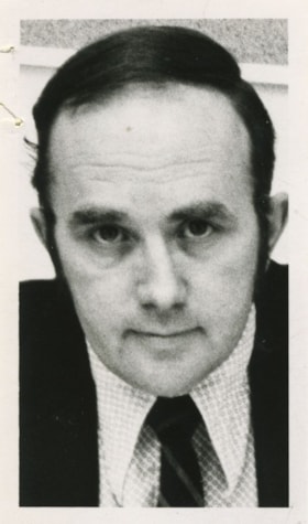
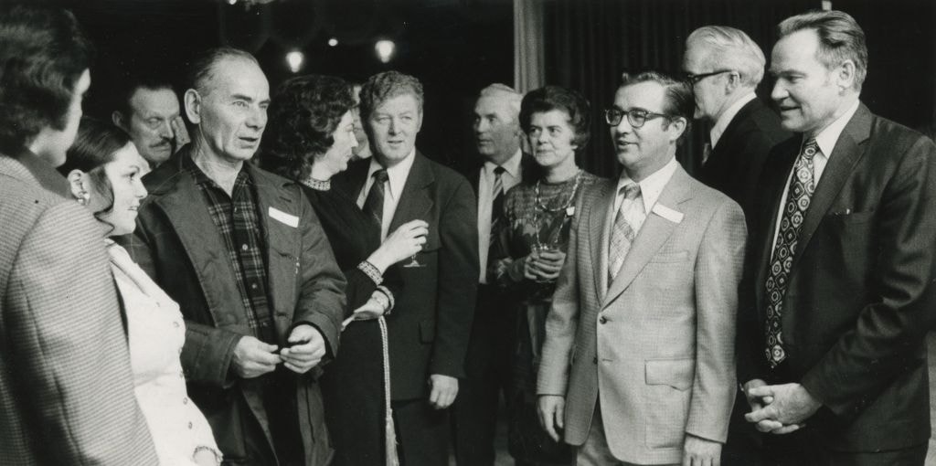
- Photograph of Lyle Armstrong, Burnaby Planning Director.
- Repository
- City of Burnaby Archives
- Date
- 1973
- Collection/Fonds
- Columbian Newspaper collection
- Physical Description
- 1 photograph : b&w ; 8 x 5 cm
- Description Level
- Item
- Record No.
- 480-1289
- Access Restriction
- No restrictions
- Reproduction Restriction
- Reproduce for fair dealing purposes only
- Accession Number
- 2009-01
- Scope and Content
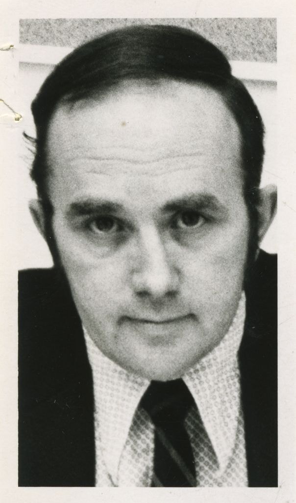
- Photograph of Lyle Armstrong, Burnaby Planning Director.
- Names
- Armstrong, Lyle
- Media Type
- Photograph
- Notes
- Title based on contents of photograph
Images
Planning the opening of the Community Centred College for the Retired
https://search.heritageburnaby.ca/link/archivedescription45231
- Repository
- City of Burnaby Archives
- Date
- 1979, published January 11, 1979
- Collection/Fonds
- Columbian Newspaper collection
- Description Level
- Item
- Physical Description
- 1 photograph : b&w ; 15 x 19.5 cm
- Scope and Content
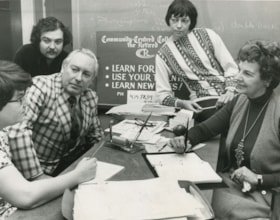
- Photograph of the planning group for the official opening of the Community Centred College for the Retired. Seated around the table are; registrar Joanne Du Brall, consultant Darryl Adam, finance coordinator Owen Sheffield, resource coordinator Marion Haden and founder Mabel Dunham.
- Repository
- City of Burnaby Archives
- Date
- 1979, published January 11, 1979
- Collection/Fonds
- Columbian Newspaper collection
- Physical Description
- 1 photograph : b&w ; 15 x 19.5 cm
- Description Level
- Item
- Record No.
- 480-127
- Access Restriction
- No restrictions
- Reproduction Restriction
- Reproduce for fair dealing purposes only
- Accession Number
- 2003-02
- Scope and Content
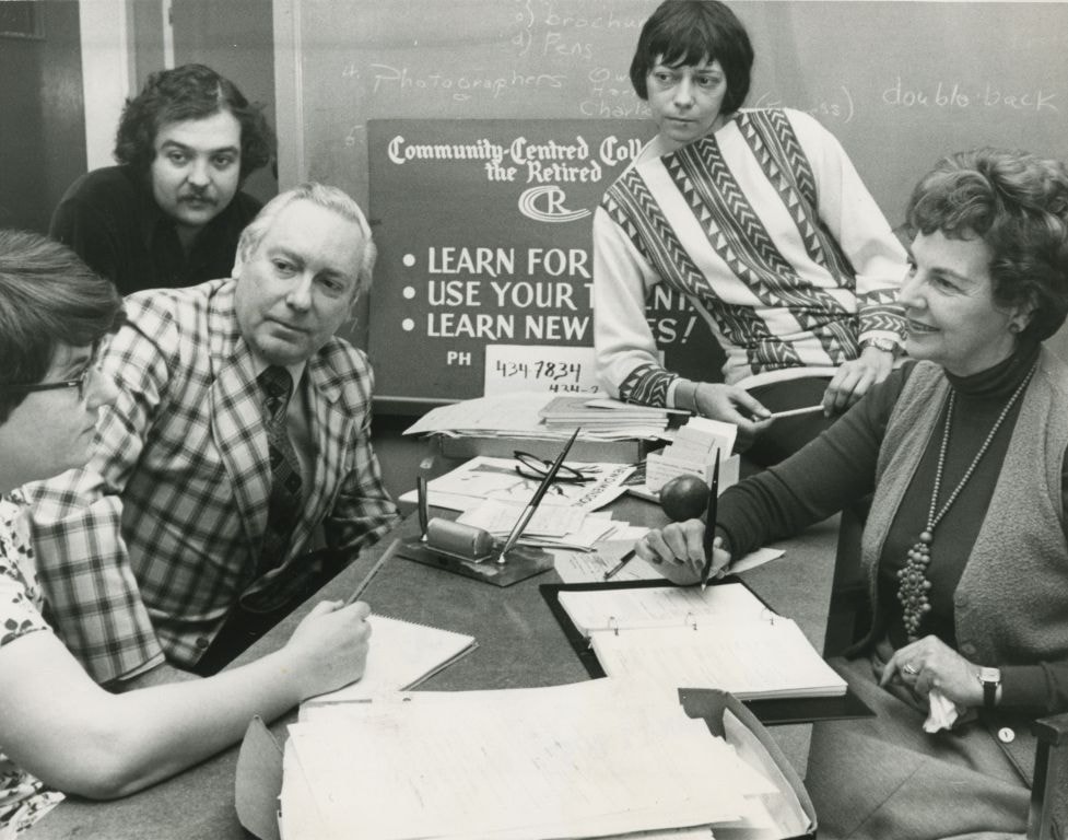
- Photograph of the planning group for the official opening of the Community Centred College for the Retired. Seated around the table are; registrar Joanne Du Brall, consultant Darryl Adam, finance coordinator Owen Sheffield, resource coordinator Marion Haden and founder Mabel Dunham.
- Names
- Du Brall, Joanne
- Adam, Darryl
- Sheffield, Owen
- Haden, Marion
- Dunham, Mabel
- Community Centred College for the Retired
- Media Type
- Photograph
- Notes
- Title based on contents of photograph
- Newspaper clipping attached to verso of photograph reads: "College official opening planned by registrar Joanne Du Brall, consultant Darryl Adam, finance co-ordinator Owen Sheffield, resource co-ordinator Marion Haden and founder Mabel Dunham. More than 500 seniors take advantage of non-profit institution."
Images

Sussex-Nelson Neighbourhood
https://search.heritageburnaby.ca/link/landmark838
- Repository
- Burnaby Heritage Planning
- Associated Dates
- 1955-2008
- Heritage Value
- The Sussex-Nelson Neighbourhood is located just south of Metrotown and in 1980 was characterised as the most populated of all of Burnaby's Planning Study areas. The area immediately south of Metrotown was initially developed as post-war 1950s housing stock, while the sector south of Rumble was developed after the 1960s and 1970s as single-family housing.
- Historic Neighbourhood
- Alta Vista (Historic Neighbourhood)
- Planning Study Area
- Sussex-Nelson Area
Images


Oakalla Neighbourhood
https://search.heritageburnaby.ca/link/landmark804
- Repository
- Burnaby Heritage Planning
- Associated Dates
- 1955-2008
- Heritage Value
- The phasing out and demolition of the Oakalla Prison farm allowed for the planned development of the Oakalla Neighbourhood in the 1980s. By 1991, the City of Burnaby had adopted the Oakalla Development Plan which called for the transfer of land to the Deer Lake Park reserve as well as the creation of a new residential area consisting of multi-family housing types.
- Historic Neighbourhood
- Central Park (Historic Neighbourhood)
- Planning Study Area
- Oakalla Area
Images


Big Bend Neighbourhood
https://search.heritageburnaby.ca/link/landmark840
- Repository
- Burnaby Heritage Planning
- Associated Dates
- 1955-2008
- Heritage Value
- The Big Bend Neighbourhood in Burnaby maintained its status as an important agricultural area in the City in the years following 1955 and it also solidified its role as a prime industrial and commercial district. In 1972, the Big Bend Development Plan was adopted by Council and soon thereafter, approximately 620 acres of land were incorporated into the Agricultural Land Reserve. These lands have been set aside for agricultural and limited recreation purposes. By the 2000s, 160 acres of land were considered highly productive agricultural areas, and over 400 acres of land had been secured as parkland, including the Fraser Foreshore Park. The area also developed large commercial and industrial districts including those at Marine Way/Boundary, the Glenlyon Estates, Riverfront Business Park, Burnaby Business Park, and Glenwood Industrial Estates.
- Historic Neighbourhood
- Fraser Arm (Historic Neighbourhood)
- Planning Study Area
- Big Bend Area
Images


Burnaby Lake Neighbourhood
https://search.heritageburnaby.ca/link/landmark821
- Repository
- Burnaby Heritage Planning
- Associated Dates
- 1955-2008
- Heritage Value
- In 1966 Burnaby Lake was identified as a key potential regional park in the GVRD ’s Regional Park Plan for the Lower Mainland. The lake was to be developed for nature study, strolling, trail riding, canoeing, sightseeing and picnicking. It was formally recognized as a regional nature park in 1979, at which time the GVRD assumed management of the park through a lease agreement with the City of Burnaby. In 1993 Burnaby Lake was selected by the City of Burnaby to be included in Greater Vancouver ’s Green Zone, and was identified as a key component of the GVRD ’s Park and Outdoor Recreation System (PORS) for the Burrard/Peninsula/Richmond sector, which includes Burnaby, Vancouver, New Westminster, and Richmond.
- Historic Neighbourhood
- Burnaby Lake (Historic Neighbourhood)
- Planning Study Area
- Burnaby Lake Area
Images


Central Park Neighbourhood
https://search.heritageburnaby.ca/link/landmark688
- Repository
- Burnaby Heritage Planning
- Associated Dates
- 1925-1954
- Heritage Value
- Although still largely a rural area during the 1920s, subdivisions began appearing in the Central Park neighbourhood at this time. Development was slowed by the Great Depression of the 1930s but the influx of commercial buildings and new housing initiatives in the post-war boom led to a period of rapid growth especially in the Garden Village subdivision which was undertaken in 1953 with the plan to build 500 modern homes in the 140-acre site. Despite the closure of the interurban line in 1953, the neighbourhood remained an active commercial and residential centre.
- Historic Neighbourhood
- Central Park (Historic Neighbourhood)
- Planning Study Area
- Maywood Area
Images


Clinton-Glenwood Neighbourhood
https://search.heritageburnaby.ca/link/landmark841
- Repository
- Burnaby Heritage Planning
- Associated Dates
- 1955-2008
- Heritage Value
- The primarily single-family subdivision and development in the Clinton-Glenwood Neighbourhood occurred during the building boom of the 1950s. Later development fell under the guidelines established in the Royal Oak Community Plan (adopted in 1999) and resulted in an increase in the number of multi-family units.
- Historic Neighbourhood
- Alta Vista (Historic Neighbourhood)
- Planning Study Area
- Clinton-Glenwood Area
Images


England House
https://search.heritageburnaby.ca/link/landmark501
- Repository
- Burnaby Heritage Planning
- Description
- The Mary England Residence is a one and one-half storey, wood-frame, Period Revival cottage with a steeply pitched, cross-gabled roof. Situated on Griffiths Drive within the Edmonds neighbourhood of Burnaby, the Mary England Residence has an original attached garage.
- Associated Dates
- 1930
- Formal Recognition
- Community Heritage Register
- Other Names
- Mary England Residence
- Street View URL
- Google Maps Street View
- Repository
- Burnaby Heritage Planning
- Other Names
- Mary England Residence
- Geographic Access
- Griffiths Drive
- Associated Dates
- 1930
- Formal Recognition
- Community Heritage Register
- Enactment Type
- Council Resolution
- Enactment Date
- 26/05/2003
- Description
- The Mary England Residence is a one and one-half storey, wood-frame, Period Revival cottage with a steeply pitched, cross-gabled roof. Situated on Griffiths Drive within the Edmonds neighbourhood of Burnaby, the Mary England Residence has an original attached garage.
- Heritage Value
- The Mary England Residence, built in 1930, is valued as a representation of the period revival styles that were popular in the era between the two World Wars. At this time, it was considered the height of fashion for a house to reflect historical styles, even when combined in an eclectic manner, that expressed a domestic ideal of cozy traditionalism. The Mary England Residence is an exuberant example of this trend. Half-timbering, multi-paned and leaded casement windows and a steeply pitched, cross-gabled roof impart a storybook cottage charm. Its first owner, Mary England, was employed for several years as stenographer at the old Burnaby Municipal Hall. An original attached garage is evidence of the growing presence of automobiles in domestic life of the 1930s. Additionally, the Mary England Residence is a testament to the continued suburban growth of the Edmonds neighbourhood. During the Edwardian era, the area experienced a housing boom. Its proximity to New Westminster, coupled with its regional transportation links, made it an attractive area for middle-class residences. Despite the economic recession of the 1930s, the Edmonds area continued to develop with modest but handsome housing.
- Defining Elements
- Key elements that define the heritage character of the Mary England Residence: - location, in the Edmonds neighbourhood of East Burnaby - residential form, scale and massing as expressed by its one and one-half storey height with full basement, rectangular plan and steeply pitched cross-gabled roof - Period Revival elements such as rough-cast stucco, half-timbering, minimal eave overhangs, arched entry with glazed wooden front door, and arched-top feature window - mixture of windows including: double-hung, multi-paned wooden sash windows in double assembly; 6-over-1 double-hung wooden sash windows in multiple assembly; multi-paned casement windows; and straight-leaded feature windows - external parged chimney and two internal chimneys - attached front-gabled garage - associated landscape features including mature deciduous trees and fruit trees
- Historic Neighbourhood
- Edmonds (Historic Neighbourhood)
- Planning Study Area
- Stride Avenue Area
- Function
- Primary Historic--Single Dwelling
- Primary Current--Single Dwelling
- Community
- Edmonds
- Cadastral Identifier
- P.I.D.011-115-424
- Boundaries
- The Mary England Residence is comprised of a single residential lot located at 7276 Griffiths Drive, Burnaby.
- Area
- 1404.26
- Contributing Resource
- Building
- Ownership
- Public (local)
- Documentation
- City of Burnaby Planning and Building Department, Heritage Site Files
- Street Address
- 7276 Griffiths Drive
- Street View URL
- Google Maps Street View
Images


Parkcrest Neighbourhood
https://search.heritageburnaby.ca/link/landmark671
- Repository
- Burnaby Heritage Planning
- Associated Dates
- 1925-1954
- Heritage Value
- On May 10, 1951, the Burnaby News-Courier reported on the new Parkcrest subdivision, saying: "Central Burnaby is the scenic locale of a successful attempt to produce modern houses economically and yet avoid the mass production effect common to other housing developments. That is one of the many highlights peculiar to the new Parkcrest development of 275 homes...By giving home purchasers a wide choice of finishes, extras and colours, hundreds of variations are possible on the six basic floor plans...Travelling time by car to Hastings and Granville from Parkcrest has been clocked at 15 minutes...Both primary and junior high schools are within walking distance. A modern shopping centre is planned for the future...Several streets are laid out in a straight but irregular manner, thus eliminating the prosaic side by side appearance block by block, as in other housing developments."
- Planning Study Area
- Parkcrest-Aubrey Area
Images


Stride Avenue Neighbourhood
https://search.heritageburnaby.ca/link/landmark845
- Repository
- Burnaby Heritage Planning
- Associated Dates
- 1955-2008
- Heritage Value
- The interurban link between New Westminster and Vancouver stimulated the early settlement of Stride Avenue. Infilling of the area took place in the early 1950s and the pace of development had slowed considerably by 1970. Duplexes became a popular feature in the decade between 1970 and 1980 and in the late 1980s, the neighbourhood was incorporated into the Edmonds Town Centre South plan.
- Historic Neighbourhood
- Edmonds (Historic Neighbourhood)
- Planning Study Area
- Stride Avenue Area
Images


Stride Hill Neighbourhood
https://search.heritageburnaby.ca/link/landmark846
- Repository
- Burnaby Heritage Planning
- Associated Dates
- 1955-2008
- Heritage Value
- The residential areas that are located within the Stride Hill Neighbourhood were primarily developed in the 1950s during Burnaby's post-war building boom. The area lying to the south of Byrne Creek Ravine Park was used as a municipal garbage dump until the 1960s and as a landfill site for yard waste disposal until the early 1990s at which point the area was incorporated into the Edmonds Town Centre Plan and the land was made into park and open space.
- Historic Neighbourhood
- Edmonds (Historic Neighbourhood)
- Planning Study Area
- Stride Hill Area
Images


Westridge Neighbourhood
https://search.heritageburnaby.ca/link/landmark680
- Repository
- Burnaby Heritage Planning
- Associated Dates
- 1925-1954
- Heritage Value
- The Westridge Neighbourhood of Burnaby was created as a new subdivision during the post-World War Two housing boom in Burnaby. Developed by the C.B. Riley Company, it was laid out in a plan contoured to the shapes of the land and was situated to allow residents easy access to main transportation routes.
- Historic Neighbourhood
- Lochdale (Historic Neighbourhood)
- Planning Study Area
- Westridge Area
Images


Windsor Neighbourhood
https://search.heritageburnaby.ca/link/landmark803
- Repository
- Burnaby Heritage Planning
- Associated Dates
- 1955-2008
- Heritage Value
- The Windsor Neighbourhood comprises a number of different districts with different characteristics. To the north, stretching to the border of the Deer Lake Park, is the primarily residential area that was developed after the building boom of the 1950s and now consists of a mix of single-family and multi-family housing. To the south, from Kingsway to the Skytrain line, an industrial area was maintained along with a significant commercial corridor along Kingsway. In recent years, the growth and development of this area has been guided by the Royal Oak Community Plan adopted by Council in 1999.
- Planning Study Area
- Windsor Area
Images


Brentwood Neighbourhood
https://search.heritageburnaby.ca/link/landmark669
- Repository
- Burnaby Heritage Planning
- Associated Dates
- 1925-1954
- Heritage Value
- In July, 1953, Burnaby's Municipal Council gave approval for the construction of a $12,000,000 residential and shopping development to be called Brentwood Park, located on the northeast corner of Lougheed and Willingdon. Plans called for about 400 homes and a 30-acre shopping centre to be built in this new subdivision - the first large residential subdivision in Burnaby to be developed with sewers and paved streets as well as other services.
- Planning Study Area
- Brentwood Area
Images


Sperling-Broadway Neighbourhood
https://search.heritageburnaby.ca/link/landmark789
- Repository
- Burnaby Heritage Planning
- Associated Dates
- 1955-2008
- Heritage Value
- By the 1970s, the Sperling-Broadway Neighbourhood was characterised as one of the Municipality's fastest growing residential areas. In 1980, it was estimated that slightly less than half of the homes were single-family residences, while the remaining development was taking the form of townhouse and high-rise apartments. The emphasis shifted back to single family housing during the construction of planned subdivisions such as the Camrose subdivision in the 1980s and the area remains primarily residential in nature. The neighbourhood is well-served by park facilities and is also home to the Burnaby Mountain Golf Course.
- Historic Neighbourhood
- Lochdale (Historic Neighbourhood)
- Planning Study Area
- Sperling-Broadway Area
Images


Willingdon Heights Neighbourhood
https://search.heritageburnaby.ca/link/landmark670
- Repository
- Burnaby Heritage Planning
- Associated Dates
- 1925-1954
- Heritage Value
- Willingdon Heights was another new subdivision developed in Burnaby during the post-World War Two building boom. A brochure about the development published in 1948 proclaimed "the Willingdon Heights 500 home development project in Burnaby fulfills its promise to provide a self-contained community for former members of the armed services and their families...the largest single veteran housing project in Canada as far as homes for individual ownership is concerned, Willingdon Heights development was planned by the Central Mortgage and Housing Corporation...At this date the earlier built rows of homes have passable roads and the owners are improving lawns and gardens in spare time...eventually additional stores and professional services will be installed and recreational projects will add to the amenities of a community of congenial residents..."
- Planning Study Area
- Willingdon Heights Area
Images


Interview with Don Brown by Rod Fowler February 26, 1990 - Track 11
https://search.heritageburnaby.ca/link/oralhistory512
- Repository
- City of Burnaby Archives
- Date Range
- 1979-1990
- Length
- 00:09:05
- Summary
- This portion of the interview is about Don Brown’s service as Alderman (1979-1985), his support for Bill Copeland in 1987 and conflicts with Mayor Bill Lewarne, and some of the issues he dealt with such as illegal suites, density planning and highrises for Hastings
- Repository
- City of Burnaby Archives
- Summary
- This portion of the interview is about Don Brown’s service as Alderman (1979-1985), his support for Bill Copeland in 1987 and conflicts with Mayor Bill Lewarne, and some of the issues he dealt with such as illegal suites, density planning and highrises for Hastings
- Date Range
- 1979-1990
- Photo Info
- Royal Canadian Mounted Police Sergeant Don Brown, November 2, 1997. Item no. 535-0979
- Length
- 00:09:05
- Interviewer
- Fowler, Rod
- Interview Date
- February 26, 1990
- Scope and Content
- Recording is of an interview with Don Brown, conducted by Rod Fowler. Don Brown was one of eleven participants interviewed as part of the SFU/Burnaby Centennial Committee's oral history series titled, "Voices of Burnaby". The interview is mainly about Don Brown’s description of the changes in Burnaby’s built and natural landscapes and socioeconomic conditions, especially between 1947 and 1975, the strong impression made on him by those changes evident in the interview. He talks about his work and career as a police officer with the Burnaby Provincial Police and RCMP. The interview also details his involvement in Burnaby politics and volunteer community groups. To view “Narrow By” terms for each track expand this description and see “Notes”.
- Biographical Notes
- Donald Neil “Don” Brown was born in Birmingham, England May 4, 1919, and immigrated with his parents and siblings to Winnipeg in 1922. At the outbreak of WWII Don Brown left high school and enlisted in the 12th Field Company, Royal Canadian Engineers, serving six years in the army. Before going overseas he married Helen Birch in 1939. In 1947 Don Brown joined the B.C. Provincial Police which was absorbed by the RCMP in 1950. He worked as a police officer in Burnaby from 1947 to 1954, and then was transferred to Ottawa (with a stop in Regina) for nine and a half years where he attended Carleton University to study forensics. In 1963 Don Brown was transferred back to Vancouver and bought and moved into a house on Watling Street in Burnaby where he still lived in 1990. Another transfer took him to Edmonton for five years, returning to Burnaby in 1975. Following retirement in 1980 with the rank of Supervisor and after 22 years in forensic laboratories, Don Brown started his own business as a private document examiner. Don Brown was active in Burnaby politics, serving as Alderman from 1979-1985. He was also involved in many community groups including the South Burnaby Men’s Club, which he helped found in 1952, as well as active in the Burnaby Historical Society, and served on the Burnaby School Board, Burnaby Centennial Committee, and the Community College for the Retired. Don and Helen Brown had six children: Donna, Don, Gina, Patricia, Christopher and Susan. Don Brown died May 16, 2009.
- Total Tracks
- 14
- Total Length
- 01:35:07
- Interviewee Name
- Brown, Donald N. "Don"
- Interviewer Bio
- Rod Fowler returned to university as a mature student in the 1980s after working about twenty years in the field of economics and computerization in business in England, Europe and Western Canada. He graduated with a BA from SFU in both History and Sociology in 1987, his MA degree in Geography in 1989, and his PhD in Cultural Geography at SFU. He taught courses in Geography, Sociology, History and Canadian Studies at several Lower Mainland colleges, before becoming a full time member of the Geography Department at Kwantlen University College.
- Collection/Fonds
- SFU/Burnaby Centennial Committee fonds
- Transcript Available
- Transcript available
- Media Type
- Sound Recording
- Web Notes
- Interviews were digitized in 2015 allowing them to be accessible on Heritage Burnaby. The digitization project was initiated by the Community Heritage Commission with support from City of Burnaby Council.
Images

Audio Tracks
Track eleven of interview with Don Brown
Track eleven of interview with Don Brown
https://search.heritageburnaby.ca/media/hpo/_Data/_Archives_Oral_Histories/_Unrestricted/MSS187-016/MSS187-016_Track%2011.mp3
Interview with Dr Blythe Eagles and Dr Violet Eagles 10-Jun-75 - Track 6
https://search.heritageburnaby.ca/link/oralhistory46
- Repository
- City of Burnaby Archives
- Date Range
- 1912-1933
- Length
- 0:07:49
- Summary
- This portion of the interview pertains to Dr Blythe Alfred Eagles and Dr Violet Evelyn (Dunbar) Eagles' thoughts on the distinct areas of Burnaby, municipal planning decisions and the municipal politics of the time.
- Repository
- City of Burnaby Archives
- Summary
- This portion of the interview pertains to Dr Blythe Alfred Eagles and Dr Violet Evelyn (Dunbar) Eagles' thoughts on the distinct areas of Burnaby, municipal planning decisions and the municipal politics of the time.
- Date Range
- 1912-1933
- Photo Info
- Mrs. Dunbar, Dr. Blythe Eagles and Dr. Violet (Dunbar) Eagles, June 1967. Item no. 404-002
- Length
- 0:07:49
- Interviewer
- Bradbury, Dr. Bettina
- Interview Date
- 10-Jun-75
- Scope and Content
- Recording is a taped interview with Dr Blythe Eagles and his wife Dr Violet Eagles by SFU (Simon Fraser University) graduate student Bettina Bradbury (and Ross S. McLeod) June 10, 1975. Major themes discussed are: the Depression, the War Years and Burnaby Lake District. To view "Narrow By" terms for each track expand this description and see "Notes".
- Biographical Notes
- Blythe's paternal grandparents, Charles and Maude Eagles immigrated to New Westminster in 1887. Their son Jack married Amelia Jane Johnston, and Blythe Eagles was born in New Westminster in 1902. In 1918 Blythe enrolled at the University of British Columbia, and took a Physiology class with eight other top students - his future wife, Violet Dunbar was the lone woman in the class. Blythe graduated in 1922, winning the Governor General's Gold Medal as top student. He received his MA in 1924 and his PhD in 1926 from the University of Toronto. He then completed his post-doctoral study at the National Institute for Medical Research in London, England. In 1933 Dr. Eagles became head of the Department of Dairying (1936-1955), Chairman of the Division of Animal Science (1955-1967), and Dean of the Faculty of Agriculture (in 1949 until his retirement in 1967). In 1968 he received an Honourary Doctor of Science Award from UBC Blythe was also one of the first appointments to the Burnaby Town Planning Commission. Violet Evelyn Dunbar was born September 29, 1899 in Ontario, the eldest child of John and Mary (Tompson) Dunbar. Violet attained her BA in 1921 and MA in 1922 from the University of British Columbia. In 1922 she attended the Provincial Normal School and within six months had a teaching certificate and taught at Lord Hudson School in 1923. In September 1923 she was awarded a two-year scholarship to the University of Toronto, where she joined Blythe in the Bio-Chemistry Department. She received a second MA and a PhD in 1929. Her graduate studies entailed research in pure proteins and enzymes related to the commercial production of cheese. Through this work she was recognized as one of the leading enzyme chemists in the country, being a senior lab instructor of biochemistry. Violet was one of the founders of the Burnaby Council of Women and active member of the International Council of Women. Blythe and Violet Eagles purchased property at Deer Lake in 1929 and began construction of their home shortly before their marriage on June 25, 1930. The Drs. Blythe and Violet Eagles Estate is a unique expression of the talents and tastes of both the Eagles and Frank Ebenezer Buck (1875-1970) who was head of the Horticultural Department and the Campus Landscape Architect at U.B.C. and established the plan for the Eagles garden while Blythe selected many of the plantings. The Eagles themselves designed the house as a romantic cottage inspired by the British Arts and Crafts style. Violet was an enthusiastic amateur gardener, maintaining and continually developing the garden. The Eagles were active volunteers in the local community as well as at UBC. When Simon Fraser University opened in Burnaby, they became well-known for entertaining dignitaries and special guests of the university in their lavish garden. After Violet's death in 1993, the estate was sold to the City of Burnaby. The funds were used to establish a Chair in Agriculture at the University of British Columbia in their memory.
- Total Tracks
- 11
- Total Length
- 1:24:01
- Interviewee Name
- Eagles, Dr. Blythe
- Eagles, Dr. Violet
- Interviewer Bio
- Bettina Bradbury teaches history and women's studies at York University. She is the author of Wife to Widow. Lives, Laws and Politics in Nineteenth-century Montreal. (Vancouver: University of British Columbia Press, June 2011), 520p; Working Families. Age, Gender and Daily Survival in Industrializing Montreal. (Toronto: Canadian Social History Series, McClelland and Stewart, 1993); (Republished Toronto: Oxford University Press, 1996) (3rd edition, Toronto: University of Toronto Press, 2007). These interviews were undertaken after she completed her MA at Simon Fraser University in 1975 with the support of an LIP grant.
- Collection/Fonds
- Burnaby Historical Society fonds
- Subseries
- Oral history subseries
- Media Type
- Sound Recording
- Web Notes
- Interview was digitized in 2010 allowing it to be accessible on Heritage Burnaby. The digitization project was initiated by the Community Heritage Commission with support from City of Burnaby Council and the BC History Digitization Program of the Irving K. Barber Learning Centre, University of British Columbia. It was recognized by the Heritage Society of BC with an award in 2012.
Images

Audio Tracks
Track six of interview with Dr Blythe Eagles and Dr Violet Eagles
Track six of interview with Dr Blythe Eagles and Dr Violet Eagles
https://search.heritageburnaby.ca/media/hpo/_Data/_Archives_Oral_Histories/_Unrestricted/100-13-08/100-13-08_Track_6.mp3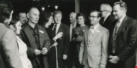
Interview with Merrill M. Gordon by Rod Fowler March 19, 1990 - Track 8
https://search.heritageburnaby.ca/link/oralhistory479
- Repository
- City of Burnaby Archives
- Date Range
- 1956-1990
- Length
- 00:10:17
- Summary
- This portion of the interview is about Merrill Gordon’s founding and operation of the youth soccer exchange with Washington State, and the importance of soccer to the community. He discusses the problem of isolation between north and south Burnaby, planned development in Burnaby, and the contributi…
- Repository
- City of Burnaby Archives
- Summary
- This portion of the interview is about Merrill Gordon’s founding and operation of the youth soccer exchange with Washington State, and the importance of soccer to the community. He discusses the problem of isolation between north and south Burnaby, planned development in Burnaby, and the contributions of Ratepayer groups and volunteers
- Date Range
- 1956-1990
- Photo Info
- Burnaby Alderman Merrill Gordon (second from right) following a candidates' meeting, 1973. Item no. 480-263
- Length
- 00:10:17
- Interviewer
- Fowler, Rod
- Interview Date
- March 19, 1990
- Scope and Content
- Recording is of an interview with Merrill Gordon, conducted by Rod Fowler.Gordon Merrill was one of eleven participants interviewed as part of the SFU/Burnaby Centennial Committee's oral history series titled, "Voices of Burnaby". The interview is about Merrill Gordon’s childhood in the Depression, including his story about the family’s difficult trek to Burnaby from Alberta; his education, teachers and first volunteer activities at Grandview High School; his career at Fleck Brothers and the start of his own company Blaze Industries and later work in India; and his many volunteer activities in Burnaby. He describes how he started the Cliff Avenue United Football Club, the soccer club's subsequent growth and development, some of the people involved, and the founding of the youth soccer exchange. He also describes his work on the Parks Board and in the arts community, including the 1987 arts centre referendum, and involvement with the Burnaby Mountain Preservation Society (1988- ), and mentions his work for other groups including the New Vista Society, library board, and Burnaby Mental Health Committee. He also talks about his political career with the Better Burnaby Committee and Burnaby Voters Association, resulting in his 1972 election to Burnaby’s 1973 council. To view “Narrow By” terms for each track expand this description and see “Notes”.
- Biographical Notes
- Merrill M. Gordon was born in Saskatchewan in 1929 to parents farming north of North Battleford. After a fifth year of crop failure the family of four left the farm in 1934 to join relatives living near the corner of Union and Sperling in Burnaby. With little resources the family adapted as well as possible in the Depression years, moving often in the East Vancouver/North Burnaby area in an attempt to better their situation. Merrill’s father obtained work at sawmills including Kapoor’s Sawmill at Barnet, walking to work over Burnaby Mountain. After attending numerous public schools, Merrill Gordon eventually spent three years at Templeton School and then completed his education at Grandview High School of Commerce, majoring in accounting and commercial law. He worked a few years at Canadian Industries Ltd., then joined Fleck Brothers. In 1965 Merrill Gordon and his wife started their own company Blaze Industries of Canada that manufactured wood burning fireplaces, selling the company to AB Electrolux in 1980. After a short retirement, Merrill Gordon went back to work in 1981 for a company manufacturing solar panels, one project taking him and his wife intermittently to India over a four year period. Merrill Gordon helped found the political group Better Burnaby Committee, later the Burnaby Voters Association, with Alan Emmott and Bill Lewarne, ran for Burnaby Municipal Council and served one year as councillor in 1973. Merrill Gordon is well known for his over 40 years of volunteer work in Burnaby, particularly as founder in 1956 and director of the Cliff Avenue United Football Club, one of the largest soccer clubs in BC. He was also the founder of Burnaby Youth Soccer and the first youth soccer exchange with Washington State. His other volunteer work includes library trustee, Parks Commissioner (1987-1992), Director of New Vista Home for Seniors, Chair of campaign raising funds for building Shadbolt Arts Centre, and Chair of the Burnaby Mental Health Committee. In 1988 Merrill Gordon, Betty Gordon, Dean Lamont and several others formed the Burnaby Mountain Preservation Society, which advocated for the return of unused land to Burnaby from SFU and the subsequent creation of Burnaby Mountain Conservation Area. Merrill Gordon and Elizabeth Balfour (nee Leitch) (1926-2012) married in 1953 and had two children.
- Total Tracks
- 11
- Total Length
- 1:31:44
- Interviewee Name
- Gordon, Merrill
- Interview Location
- unknown
- Interviewer Bio
- Rod Fowler returned to university as a mature student in the 1980s after working about twenty years in the field of economics and computerization in business in England, Europe and Western Canada. He graduated with a BA from SFU in both History and Sociology in 1987, his MA degree in Geography in 1989, and his PhD in Cultural Geography at SFU. He taught courses in Geography, Sociology, History and Canadian Studies at several Lower Mainland colleges, before becoming a full time member of the Geography Department at Kwantlen University College.
- Collection/Fonds
- SFU/Burnaby Centennial Committee fonds
- Transcript Available
- Transcript available
- Media Type
- Sound Recording
- Web Notes
- Interviews were digitized in 2015 allowing them to be accessible on Heritage Burnaby. The digitization project was initiated by the Community Heritage Commission with support from City of Burnaby Council.
Images
Audio Tracks
Track eight of interview with Merrill Gordon
Track eight of interview with Merrill Gordon
https://search.heritageburnaby.ca/media/hpo/_Data/_Archives_Oral_Histories/_Unrestricted/MSS187-020/MSS187-020_Track_8.mp3