Narrow Results By
Subject
- Advertising Medium - Signs and Signboards 3
- Aerial Photographs 3
- Agriculture - Farms 1
- Buildings - Commercial 3
- Buildings - Commercial - Offices 4
- Buildings - Commercial - Restaurants 1
- Buildings - Heritage 4
- Buildings - Residential - Cabins 1
- Buildings - Residential - Houses 1
- Construction - Road Construction 1
- Industries - Forestry 2
- Industries - Logging/lumber 2

BC Tel Building
https://search.heritageburnaby.ca/link/archivedescription93609
- Repository
- City of Burnaby Archives
- Date
- October 16, 1977
- Collection/Fonds
- Burnaby Public Library Contemporary Visual Archive Project
- Description Level
- Item
- Physical Description
- 1 photograph : b&w ; 12.5 x 17.5 cm
- Scope and Content
- Photograph of the BC Tel Building (now the Brian Canfield Centre), located at Kingsway and Boundary Road. The photograph is taken facing north and shows the pedestrian overpass over Kingsway and the mountains in the background.
- Repository
- City of Burnaby Archives
- Date
- October 16, 1977
- Collection/Fonds
- Burnaby Public Library Contemporary Visual Archive Project
- Physical Description
- 1 photograph : b&w ; 12.5 x 17.5 cm
- Description Level
- Item
- Record No.
- 556-566
- Access Restriction
- No restrictions
- Reproduction Restriction
- Reproduce for fair dealing purposes only
- Accession Number
- 2017-57
- Scope and Content
- Photograph of the BC Tel Building (now the Brian Canfield Centre), located at Kingsway and Boundary Road. The photograph is taken facing north and shows the pedestrian overpass over Kingsway and the mountains in the background.
- Media Type
- Photograph
- Photographer
- McGillivray, Don
- Notes
- Title taken from project information form
- Accompanied by a project information form and 1 photograph (b&w negative ; 9.5 x 12.5 cm)
- BPL no. 10
- Geographic Access
- Boundary Road
- Kingsway
- Street Address
- 3777 Kingsway
- Historic Neighbourhood
- Central Park (Historic Neighbourhood)
- Planning Study Area
- Garden Village Area
Images


BC Tel Building
https://search.heritageburnaby.ca/link/archivedescription93678
- Repository
- City of Burnaby Archives
- Date
- June 4, 1978
- Collection/Fonds
- Burnaby Public Library Contemporary Visual Archive Project
- Description Level
- Item
- Physical Description
- 1 photograph : b&w ; 17.5 x 12.5 cm
- Scope and Content
- Photograph of the exterior of the BC Tel Building, located at Kingsway and Boundary Road, and the lawn and roads in front of the building. The photograph is taken from a high point across the intersection, facing southeast.
- Repository
- City of Burnaby Archives
- Date
- June 4, 1978
- Collection/Fonds
- Burnaby Public Library Contemporary Visual Archive Project
- Physical Description
- 1 photograph : b&w ; 17.5 x 12.5 cm
- Description Level
- Item
- Record No.
- 556-635
- Access Restriction
- No restrictions
- Reproduction Restriction
- Reproduce for fair dealing purposes only
- Accession Number
- 2017-57
- Scope and Content
- Photograph of the exterior of the BC Tel Building, located at Kingsway and Boundary Road, and the lawn and roads in front of the building. The photograph is taken from a high point across the intersection, facing southeast.
- Subjects
- Buildings - Commercial - Offices
- Media Type
- Photograph
- Photographer
- Chapman, Fred
- Notes
- Title taken from project information form
- Accompanied by a project information form and 1 photograph (b&w negative ; 12.5 x 9.5 cm)
- BPL no. 84
- Geographic Access
- Boundary Road
- Kingsway
- Street Address
- 3777 Kingsway
- Historic Neighbourhood
- Central Park (Historic Neighbourhood)
- Planning Study Area
- Garden Village Area
Images


BC Tel Building
https://search.heritageburnaby.ca/link/archivedescription93679
- Repository
- City of Burnaby Archives
- Date
- June 4, 1978
- Collection/Fonds
- Burnaby Public Library Contemporary Visual Archive Project
- Description Level
- Item
- Physical Description
- 1 photograph : b&w ; 12.5 x 17.5 cm
- Scope and Content
- Photograph of the exterior of the BC Tel Building, located at Kingsway and Boundary Road. The photograph is taken from across a lawn and railway tracks, facing southeast. The railway tracks are visible in the bottom left corner of the photograph.
- Repository
- City of Burnaby Archives
- Date
- June 4, 1978
- Collection/Fonds
- Burnaby Public Library Contemporary Visual Archive Project
- Physical Description
- 1 photograph : b&w ; 12.5 x 17.5 cm
- Description Level
- Item
- Record No.
- 556-636
- Access Restriction
- No restrictions
- Reproduction Restriction
- Reproduce for fair dealing purposes only
- Accession Number
- 2017-57
- Scope and Content
- Photograph of the exterior of the BC Tel Building, located at Kingsway and Boundary Road. The photograph is taken from across a lawn and railway tracks, facing southeast. The railway tracks are visible in the bottom left corner of the photograph.
- Media Type
- Photograph
- Photographer
- Chapman, Fred
- Notes
- Title taken from project information form
- Accompanied by a project information form and 1 photograph (b&w negative ; 9.5 x 12.5 cm)
- BPL no. 85
- Geographic Access
- Boundary Road
- Kingsway
- Street Address
- 3777 Kingsway
- Historic Neighbourhood
- Central Park (Historic Neighbourhood)
- Planning Study Area
- Garden Village Area
Images


BC Tel Building
https://search.heritageburnaby.ca/link/archivedescription93680
- Repository
- City of Burnaby Archives
- Date
- June 4, 1978
- Collection/Fonds
- Burnaby Public Library Contemporary Visual Archive Project
- Description Level
- Item
- Physical Description
- 1 photograph : b&w ; 12.5 x 17.5 cm
- Scope and Content
- Photograph of the exterior of the BC Tel Building, located at Kingsway and Boundary Road, and the lawn and neighbourhood surrounding the building. The photograph is taken from across the lawn, facing north. Boundary Road is on the left side of the photograph and the mountains are visible in the bac…
- Repository
- City of Burnaby Archives
- Date
- June 4, 1978
- Collection/Fonds
- Burnaby Public Library Contemporary Visual Archive Project
- Physical Description
- 1 photograph : b&w ; 12.5 x 17.5 cm
- Description Level
- Item
- Record No.
- 556-637
- Access Restriction
- No restrictions
- Reproduction Restriction
- Reproduce for fair dealing purposes only
- Accession Number
- 2017-57
- Scope and Content
- Photograph of the exterior of the BC Tel Building, located at Kingsway and Boundary Road, and the lawn and neighbourhood surrounding the building. The photograph is taken from across the lawn, facing north. Boundary Road is on the left side of the photograph and the mountains are visible in the background.
- Media Type
- Photograph
- Photographer
- Chapman, Fred
- Notes
- Title taken from project information form
- Accompanied by a project information form and 1 photograph (b&w negative ; 9.5 x 12.5 cm)
- BPL no. 86
- Geographic Access
- Kingsway
- Boundary Road
- Street Address
- 3777 Kingsway
- Historic Neighbourhood
- Central Park (Historic Neighbourhood)
- Planning Study Area
- Garden Village Area
Images


Billboards at Hastings and Boundary
https://search.heritageburnaby.ca/link/archivedescription79163
- Repository
- City of Burnaby Archives
- Date
- November 1, 1976
- Collection/Fonds
- Burnaby Public Library Contemporary Visual Archive Project
- Description Level
- Item
- Physical Description
- 1 photograph : b&w ; 11 x 16 cm mounted on cardboard
- Scope and Content
- Photograph shows men working on billboards above Moffat's Furniture at the corner of Hastings Street and Boundary Road.
- Repository
- City of Burnaby Archives
- Date
- November 1, 1976
- Collection/Fonds
- Burnaby Public Library Contemporary Visual Archive Project
- Physical Description
- 1 photograph : b&w ; 11 x 16 cm mounted on cardboard
- Description Level
- Item
- Record No.
- 556-182
- Access Restriction
- No restrictions
- Reproduction Restriction
- Reproduce for fair dealing purposes only
- Accession Number
- 2013-13
- Scope and Content
- Photograph shows men working on billboards above Moffat's Furniture at the corner of Hastings Street and Boundary Road.
- Names
- Moffat's Furniture
- Media Type
- Photograph
- Notes
- Scope note taken directly from BPL photograph description.
- 1 b&w copy negative : 10 x 12.5 cm accompanying
- Photographers identified by surnames only: Carr and Vardeman
- Geographic Access
- Hastings Street
- Boundary Road
- Historic Neighbourhood
- Vancouver Heights (Historic Neighbourhood)
- Planning Study Area
- Willingdon Heights Area
Images


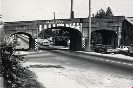
Boundary Road
https://search.heritageburnaby.ca/link/archivedescription79966
- Repository
- City of Burnaby Archives
- Date
- September 27, 1976
- Collection/Fonds
- Burnaby Public Library Contemporary Visual Archive Project
- Description Level
- Item
- Physical Description
- 1 photograph : b&w ; 11 x 16 cm mounted on cardboard
- Scope and Content
- Photograph shows a view of Boundary Road looking south from the railway trestle just north of Kingsway.
- Repository
- City of Burnaby Archives
- Date
- September 27, 1976
- Collection/Fonds
- Burnaby Public Library Contemporary Visual Archive Project
- Physical Description
- 1 photograph : b&w ; 11 x 16 cm mounted on cardboard
- Description Level
- Item
- Record No.
- 556-529
- Access Restriction
- No restrictions
- Reproduction Restriction
- Reproduce for fair dealing purposes only
- Accession Number
- 2013-13
- Scope and Content
- Photograph shows a view of Boundary Road looking south from the railway trestle just north of Kingsway.
- Subjects
- Aerial Photographs
- Media Type
- Photograph
- Photographer
- Norton, Paul
- Notes
- Scope note taken directly from BPL photograph description.
- 1 b&w copy negative : 10 x 12.5 cm accompanying
- Geographic Access
- Boundary Road
- Historic Neighbourhood
- Central Park (Historic Neighbourhood)
- Planning Study Area
- Garden Village Area
Images


Boundary Road
https://search.heritageburnaby.ca/link/archivedescription79967
- Repository
- City of Burnaby Archives
- Date
- September 27, 1976
- Collection/Fonds
- Burnaby Public Library Contemporary Visual Archive Project
- Description Level
- Item
- Physical Description
- 1 photograph : b&w ; 11 x 16 cm mounted on cardboard
- Scope and Content
- Photograph shows a view of Boundary Road looking north from the railway trestle just north of Kingsway.
- Repository
- City of Burnaby Archives
- Date
- September 27, 1976
- Collection/Fonds
- Burnaby Public Library Contemporary Visual Archive Project
- Physical Description
- 1 photograph : b&w ; 11 x 16 cm mounted on cardboard
- Description Level
- Item
- Record No.
- 556-530
- Access Restriction
- No restrictions
- Reproduction Restriction
- Reproduce for fair dealing purposes only
- Accession Number
- 2013-13
- Scope and Content
- Photograph shows a view of Boundary Road looking north from the railway trestle just north of Kingsway.
- Subjects
- Aerial Photographs
- Media Type
- Photograph
- Photographer
- Norton, Paul
- Notes
- Scope note taken directly from BPL photograph description.
- 1 b&w copy negative : 10 x 12.5 cm accompanying
- Geographic Access
- Boundary Road
- Historic Neighbourhood
- Central Park (Historic Neighbourhood)
- Planning Study Area
- Garden Village Area
Images


Boundary Road
https://search.heritageburnaby.ca/link/archivedescription79989
- Repository
- City of Burnaby Archives
- Date
- October, 1976
- Collection/Fonds
- Burnaby Public Library Contemporary Visual Archive Project
- Description Level
- Item
- Physical Description
- 1 photograph : b&w ; 11 x 16 cm mounted on cardboard
- Scope and Content
- Photograph shows view of Boundary Road and the North Shore mountains from 1st Avenue.
- Repository
- City of Burnaby Archives
- Date
- October, 1976
- Collection/Fonds
- Burnaby Public Library Contemporary Visual Archive Project
- Physical Description
- 1 photograph : b&w ; 11 x 16 cm mounted on cardboard
- Description Level
- Item
- Record No.
- 556-545
- Access Restriction
- No restrictions
- Reproduction Restriction
- Reproduce for fair dealing purposes only
- Accession Number
- 2013-13
- Scope and Content
- Photograph shows view of Boundary Road and the North Shore mountains from 1st Avenue.
- Subjects
- Aerial Photographs
- Media Type
- Photograph
- Photographer
- Cook, Alan
- Notes
- Scope note taken directly from BPL photograph description.
- 1 b&w copy negative : 10 x 12.5 cm accompanying
- Geographic Access
- Boundary Road
- Historic Neighbourhood
- Broadview (Historic Neighbourhood)
- Planning Study Area
- West Central Valley Area
Images


Boundary Road Lumber Mill
https://search.heritageburnaby.ca/link/archivedescription38262
- Repository
- City of Burnaby Archives
- Date
- 1908
- Collection/Fonds
- Burnaby Historical Society fonds
- Description Level
- Item
- Physical Description
- 1 photograph : sepia ; 9 x 12 cm on 12.5 x 15 cm backing
- Scope and Content
- Photograph of an unidentified man standing in the forefront with a jersey cow to the right, while a row of cabins and cleared tress can be seen in the background. A caption written above the photograph reads: "Boundary Road Lumber Mill owned by E.W. Nicholson." Underneath the photograph is writte…
- Repository
- City of Burnaby Archives
- Date
- 1908
- Collection/Fonds
- Burnaby Historical Society fonds
- Subseries
- Margaret McCallum subseries
- Physical Description
- 1 photograph : sepia ; 9 x 12 cm on 12.5 x 15 cm backing
- Description Level
- Item
- Record No.
- 375-024
- Access Restriction
- No restrictions
- Reproduction Restriction
- No known restrictions
- Accession Number
- BHS1986-42
- Scope and Content
- Photograph of an unidentified man standing in the forefront with a jersey cow to the right, while a row of cabins and cleared tress can be seen in the background. A caption written above the photograph reads: "Boundary Road Lumber Mill owned by E.W. Nicholson." Underneath the photograph is written: "The first Jersey cow on the farm." On the back of the photograph it is noted that the buildings in the background were workmen's buildings.
- Media Type
- Photograph
- Notes
- Title based on caption
- Geographic Access
- Boundary Road
- Still Creek
- Street Address
- 2550 Boundary Road
- Historic Neighbourhood
- Broadview (Historic Neighbourhood)
- Planning Study Area
- West Central Valley Area
Images


Burnaby's Operation Identification
https://search.heritageburnaby.ca/link/archivedescription45330
- Repository
- City of Burnaby Archives
- Date
- 1976, published January 7, 1976
- Collection/Fonds
- Columbian Newspaper collection
- Description Level
- Item
- Physical Description
- 1 photograph : b&w ; 22.5 x 14.5 cm
- Scope and Content
- Photograph of municipal workers Bill Ramsay and Greg Finch putting up a sign in preparation for Burnaby's Operation Identification, which was "the largest single crime prevention policy of its kind in Canada" when "47 uniformed officers of the Burnaby detachment [joined] 47 Rotarians from the Burna…
- Repository
- City of Burnaby Archives
- Date
- 1976, published January 7, 1976
- Collection/Fonds
- Columbian Newspaper collection
- Physical Description
- 1 photograph : b&w ; 22.5 x 14.5 cm
- Description Level
- Item
- Record No.
- 480-225
- Access Restriction
- No restrictions
- Reproduction Restriction
- No restrictions
- Accession Number
- 2003-02
- Scope and Content
- Photograph of municipal workers Bill Ramsay and Greg Finch putting up a sign in preparation for Burnaby's Operation Identification, which was "the largest single crime prevention policy of its kind in Canada" when "47 uniformed officers of the Burnaby detachment [joined] 47 Rotarians from the Burnaby Kingsway Rotary Club and start door-to-door visits in 800 residences in South Burnaby. The teams [carried] electric engraving pens for marking all property susceptible to theft."
- Media Type
- Photograph
- Photographer
- King, Basil
- Notes
- Title based on contents of photograph
- Newspaper clipping attached to verso of photograph reads: "Burnaby detachment of the RCMP has embarked on the largest single crime prevention policy of its kind in Canada. "Operation Identification" officially kicks off tonight when 47 uniformed officers of the Burnaby detachment will join with 47 Rotarians from the Burnaby Kingsway Rotary Club and start door-to-door visits in 800 residences in South Burnaby. The teams will be carrying electric engraving pens for marking all property susceptible to theft. Municipal workers Bill Ramsay and Greg Finch are shown erecting one of the signs on Canada Way at 14th Avenue as "sidewalk superintendents" Sandra Finch and Corinne Williams look on."
- Geographic Access
- Canada Way
- 14th Avenue
- Historic Neighbourhood
- Edmonds (Historic Neighbourhood)
- Planning Study Area
- Edmonds Area
Images

![Corner view of Love farmhouse, [between 1966 and 1970] thumbnail](/media/hpo/_Data/_BVM_Images/2019/2019_0003_0005_001.jpg?width=280)
Corner view of Love farmhouse
https://search.heritageburnaby.ca/link/museumdescription9919
- Repository
- Burnaby Village Museum
- Date
- [between 1966 and 1970]
- Collection/Fonds
- Love family fonds
- Description Level
- Item
- Physical Description
- 1 photograph : col. ; 10 x 15 cm print
- Scope and Content
- Photograph of the exterior of the Love farmhouse taken at the corner of Fourteenth Avenue and Cumberland Street. The house is hidden behind large trees at it's orignal address of 7651 Cumberland Street (Address pre 1960: 1390 Cumberland Road). This photograph was taken while Elsie Hughes (nee Love)…
- Repository
- Burnaby Village Museum
- Collection/Fonds
- Love family fonds
- Description Level
- Item
- Physical Description
- 1 photograph : col. ; 10 x 15 cm print
- Material Details
- Copy print was made from re-photographing an original colour slide
- Scope and Content
- Photograph of the exterior of the Love farmhouse taken at the corner of Fourteenth Avenue and Cumberland Street. The house is hidden behind large trees at it's orignal address of 7651 Cumberland Street (Address pre 1960: 1390 Cumberland Road). This photograph was taken while Elsie Hughes (nee Love), her husband John Hughes and son Brent Hughes lived in the house. Elsie is the daughter of Sarah (nee Love) and William Parker. Sarah and William purchased the house in 1928, shortly after the death of Sarah's father, Jesse Love. Sarah and William Parker lived in the house with their three children, Albert, Bill and Elsie. William Parker died in 1961 and Sarah continued to live in the house until 1966 before selling it to her daughter Elsie and son in law John Hughes. Elsie and John lived in the house with their son Brent until 1971.
- Subjects
- Buildings - Heritage
- Geographic Access
- 14th Avenue
- Cumberland Street
- Street Address
- 7651 Cumberland Street
- Accession Code
- BV019.3.5
- Access Restriction
- No restrictions
- Reproduction Restriction
- No known restrictions
- Date
- [between 1966 and 1970]
- Media Type
- Photograph
- Historic Neighbourhood
- East Burnaby (Historic Neighbourhood)
- Planning Study Area
- Cariboo-Armstrong Area
- Scan Resolution
- 600
- Scan Date
- 31-Jan-2019
- Scale
- 96
- Photographer
- Parker, Albert "Bert"
- Notes
- Title based on contents of photograph
- See also BV992.15.12
Images
![Corner view of Love farmhouse, [between 1966 and 1970] thumbnail](/media/hpo/_Data/_BVM_Images/2019/2019_0003_0005_001.jpg)
![Corner view of Love farmhouse, [between 1966 and 1970] thumbnail](/media/hpo/_Data/_BVM_Images/2019/2019_0003_0006_001.jpg?width=280)
Corner view of Love farmhouse
https://search.heritageburnaby.ca/link/museumdescription9920
- Repository
- Burnaby Village Museum
- Date
- [between 1966 and 1970]
- Collection/Fonds
- Love family fonds
- Description Level
- Item
- Physical Description
- 1 photograph : col. ; 10 x 15 cm print
- Scope and Content
- Photograph of the exterior of the Love farmhouse taken at the corner of Fourteenth Avenue and Cumberland Street. The north side of the house and kitchen are in view with large trees covering the front of the house at it's orignal address of 7651 Cumberland Street (Address pre 1960: 1390 Cumberland …
- Repository
- Burnaby Village Museum
- Collection/Fonds
- Love family fonds
- Description Level
- Item
- Physical Description
- 1 photograph : col. ; 10 x 15 cm print
- Material Details
- Copy print was made from re-photographing an original colour slide
- Scope and Content
- Photograph of the exterior of the Love farmhouse taken at the corner of Fourteenth Avenue and Cumberland Street. The north side of the house and kitchen are in view with large trees covering the front of the house at it's orignal address of 7651 Cumberland Street (Address pre 1960: 1390 Cumberland Road). This photograph was taken while Elsie Hughes (nee Love), her husband John Hughes and son Brent Hughes lived in the house. Elsie is the daughter of Sarah (nee Love) and William Parker. Sarah and William purchased the house in 1928, shortly after the death of Sarah's father, Jesse Love. Sarah and William Parker lived in the house with their three children, Albert, Bill and Elsie. William Parker died in 1961 and Sarah continued to live in the house until 1966 before selling it to her daughter Elsie and son in law John Hughes. Elsie and John lived in the house with their son Brent until 1971.
- Subjects
- Buildings - Heritage
- Geographic Access
- 14th Avenue
- Cumberland Street
- Street Address
- 7651 Cumberland Street
- Accession Code
- BV019.3.6
- Access Restriction
- No restrictions
- Reproduction Restriction
- No known restrictions
- Date
- [between 1966 and 1970]
- Media Type
- Photograph
- Historic Neighbourhood
- East Burnaby (Historic Neighbourhood)
- Planning Study Area
- Cariboo-Armstrong Area
- Scan Resolution
- 600
- Scan Date
- 31-Jan-2019
- Scale
- 96
- Photographer
- Parker, Albert "Bert"
- Notes
- Title based on contents of photograph
- See also BV992.15.12
Images
![Corner view of Love farmhouse, [between 1966 and 1970] thumbnail](/media/hpo/_Data/_BVM_Images/2019/2019_0003_0006_001.jpg)

Edward W. Nicholson and Team of Horses Inside Tree Stump
https://search.heritageburnaby.ca/link/archivedescription38266
- Repository
- City of Burnaby Archives
- Date
- 1909
- Collection/Fonds
- Burnaby Historical Society fonds
- Description Level
- Item
- Physical Description
- 1 photograph : sepia ; 11 x 16.5 cm on 17.8 x 22.5 cm backing
- Scope and Content
- Photograph of Edward Nicholson standing with a team of horses inside the hollowed stump of a tree. Five other men and a dog are seated on planks on top of the stump and another man and two women are sitting to the left on the exposed roots of the tree. The man on seated to the right is identified …
- Repository
- City of Burnaby Archives
- Date
- 1909
- Collection/Fonds
- Burnaby Historical Society fonds
- Subseries
- Margaret McCallum subseries
- Physical Description
- 1 photograph : sepia ; 11 x 16.5 cm on 17.8 x 22.5 cm backing
- Description Level
- Item
- Record No.
- 375-028
- Access Restriction
- No restrictions
- Reproduction Restriction
- No known restrictions
- Accession Number
- BHS1986-42
- Scope and Content
- Photograph of Edward Nicholson standing with a team of horses inside the hollowed stump of a tree. Five other men and a dog are seated on planks on top of the stump and another man and two women are sitting to the left on the exposed roots of the tree. The man on seated to the right is identified as Duncan MacInnes.
- Subjects
- Transportation - Horses
- Plants - Trees
- Media Type
- Photograph
- Notes
- Title based on caption
- A note on the back of the photograph reads: "E.W. Nicholson first resident of Broadview District of Burnaby - 1900 May 23rd. Picture taken 1909. Edward W. Nicholson, with team of horses inside stump (Cedar). Stump 36 feet in diameter. Duncan MacInnes sitting extreme right. Horses were turned around inside stump."
- Geographic Access
- Boundary Road
- Street Address
- 2550 Boundary Road
- Historic Neighbourhood
- Broadview (Historic Neighbourhood)
- Planning Study Area
- West Central Valley Area
Images


Exterior of Love farmhouse
https://search.heritageburnaby.ca/link/museumdescription1131
- Repository
- Burnaby Village Museum
- Date
- 1971 (date of original), copied 1990
- Collection/Fonds
- Love family fonds
- Description Level
- Item
- Physical Description
- 1 photograph : col. ; 10 x 15 cm print
- Scope and Content
- Photograph of the exterior of the Love farmhouse taken from the corner of Fourteenth Avenue and Cumberland Street while Elsie (nee Love) Hughes, her husband John and son Brent lived in the house. The house was located at 7651 Cumberland Street (Address pre 1960: 1390 Cumberland Road) and was moved …
- Repository
- Burnaby Village Museum
- Collection/Fonds
- Love family fonds
- Description Level
- Item
- Physical Description
- 1 photograph : col. ; 10 x 15 cm print
- Material Details
- Copy print was made from re-photographing an original colour slide
- Scope and Content
- Photograph of the exterior of the Love farmhouse taken from the corner of Fourteenth Avenue and Cumberland Street while Elsie (nee Love) Hughes, her husband John and son Brent lived in the house. The house was located at 7651 Cumberland Street (Address pre 1960: 1390 Cumberland Road) and was moved from its original site to the Burnaby Village Museum in 1988 and designated a Municipal Heritage Landmark in 1992.
- Geographic Access
- Cumberland Street
- 14th Avenue
- Street Address
- 7651 Cumberland Street
- Accession Code
- BV992.15.12
- Access Restriction
- Restricted access
- Reproduction Restriction
- May be restricted by third party rights
- Date
- 1971 (date of original), copied 1990
- Media Type
- Photograph
- Historic Neighbourhood
- East Burnaby (Historic Neighbourhood)
- Planning Study Area
- Cariboo-Armstrong Area
- Scan Resolution
- 600
- Scan Date
- 01-Jun-09
- Scale
- 100
- Photographer
- Parker, Albert "Bert"
- Notes
- Title based on contents of photograph
Images


Hanna Medical Clinic
https://search.heritageburnaby.ca/link/archivedescription79574
- Repository
- City of Burnaby Archives
- Date
- September 10, 1976
- Collection/Fonds
- Burnaby Public Library Contemporary Visual Archive Project
- Description Level
- Item
- Physical Description
- 1 photograph : b&w ; 11 x 16 cm mounted on cardboard
- Scope and Content
- Photograph shows the Hanna Medical Clinic at 3300 Boundary Road on the corner of Schou Street. The clinic was built by Dr. R. J. Hanna.
- Repository
- City of Burnaby Archives
- Date
- September 10, 1976
- Collection/Fonds
- Burnaby Public Library Contemporary Visual Archive Project
- Physical Description
- 1 photograph : b&w ; 11 x 16 cm mounted on cardboard
- Description Level
- Item
- Record No.
- 556-339
- Access Restriction
- No restrictions
- Reproduction Restriction
- Reproduce for fair dealing purposes only
- Accession Number
- 2013-13
- Scope and Content
- Photograph shows the Hanna Medical Clinic at 3300 Boundary Road on the corner of Schou Street. The clinic was built by Dr. R. J. Hanna.
- Names
- Hanna Medical Clinic
- Media Type
- Photograph
- Photographer
- Norton, Paul
- Notes
- Scope note taken directly from BPL photograph description.
- 1 b&w copy negative : 10 x 12.5 cm accompanying
- Geographic Access
- Boundary Road
- Street Address
- 3300 Boundary Road
- Historic Neighbourhood
- Broadview (Historic Neighbourhood)
- Planning Study Area
- Cascade-Schou Area
Images


House at 5170 Boundary Road
https://search.heritageburnaby.ca/link/archivedescription78963
- Repository
- City of Burnaby Archives
- Date
- September 9,1976
- Collection/Fonds
- Burnaby Public Library Contemporary Visual Archive Project
- Description Level
- Item
- Physical Description
- 1 photograph : b&w ; 11 x 16 cm mounted on cardboard
- Scope and Content
- Photograph shows a house at 5170 Boundary Road on the corner of Burke Street. The house was constructed in 1911. The home is known as the Minerva Jane Coburn house.
- Repository
- City of Burnaby Archives
- Date
- September 9,1976
- Collection/Fonds
- Burnaby Public Library Contemporary Visual Archive Project
- Physical Description
- 1 photograph : b&w ; 11 x 16 cm mounted on cardboard
- Description Level
- Item
- Record No.
- 556-054
- Access Restriction
- No restrictions
- Reproduction Restriction
- Reproduce for fair dealing purposes only
- Accession Number
- 2013-13
- Scope and Content
- Photograph shows a house at 5170 Boundary Road on the corner of Burke Street. The house was constructed in 1911. The home is known as the Minerva Jane Coburn house.
- Subjects
- Buildings - Heritage
- Media Type
- Photograph
- Photographer
- Norton, Paul
- Notes
- Scope note taken directly from BPL photograph description.
- 1 b&w copy negative : 10 x 12.5 cm accompanying
- Geographic Access
- Boundary Road
- Street Address
- 5170 Boundary Road
- Historic Neighbourhood
- Central Park (Historic Neighbourhood)
- Planning Study Area
- Garden Village Area
Images

![Lumber Camp and Mill, [between 1906 and 1908] thumbnail](/media/hpo/_Data/_Archives_Images/_Unrestricted/371/375-029.jpg?width=280)
Lumber Camp and Mill
https://search.heritageburnaby.ca/link/archivedescription38267
- Repository
- City of Burnaby Archives
- Date
- [between 1906 and 1908]
- Collection/Fonds
- Burnaby Historical Society fonds
- Description Level
- Item
- Physical Description
- 1 photograph : sepia ; 11.8 x 17 cm on 17.7 x 22.7 cm backing
- Scope and Content
- Photograph of the Nicholson lumber camp and mill in the Broadview area of Burnaby. Approximately 12 men and women can be seen standing in front of the cabins and piles of planks (all are unidentified).
- Repository
- City of Burnaby Archives
- Date
- [between 1906 and 1908]
- Collection/Fonds
- Burnaby Historical Society fonds
- Subseries
- Margaret McCallum subseries
- Physical Description
- 1 photograph : sepia ; 11.8 x 17 cm on 17.7 x 22.7 cm backing
- Description Level
- Item
- Record No.
- 375-029
- Access Restriction
- No restrictions
- Reproduction Restriction
- No known restrictions
- Accession Number
- BHS1986-42
- Scope and Content
- Photograph of the Nicholson lumber camp and mill in the Broadview area of Burnaby. Approximately 12 men and women can be seen standing in front of the cabins and piles of planks (all are unidentified).
- Subjects
- Buildings - Residential - Cabins
- Industries - Forestry
- Occupations - Lumberjacks
- Industries - Logging/lumber
- Media Type
- Photograph
- Notes
- Title based on caption
- A note on the back of the photograph reads: "Lumber camp and mill at Boundary Road and Great Northern Railway 1906-1908 (before railway existed)."
- Geographic Access
- Boundary Road
- Street Address
- 2550 Boundary Road
- Historic Neighbourhood
- Broadview (Historic Neighbourhood)
- Planning Study Area
- West Central Valley Area
Images
![Lumber Camp and Mill, [between 1906 and 1908] thumbnail](/media/hpo/_Data/_Archives_Images/_Unrestricted/371/375-029.jpg)

Municipal Road Crew
https://search.heritageburnaby.ca/link/archivedescription79439
- Repository
- City of Burnaby Archives
- Date
- September 23, 1976
- Collection/Fonds
- Burnaby Public Library Contemporary Visual Archive Project
- Description Level
- Item
- Physical Description
- 1 photograph : b&w ; 11 x 16 cm mounted on cardboard
- Scope and Content
- Photograph shows a municipal road crew resurfacing Boundary Road near Imperial Street.
- Repository
- City of Burnaby Archives
- Date
- September 23, 1976
- Collection/Fonds
- Burnaby Public Library Contemporary Visual Archive Project
- Physical Description
- 1 photograph : b&w ; 11 x 16 cm mounted on cardboard
- Description Level
- Item
- Record No.
- 556-291
- Access Restriction
- No restrictions
- Reproduction Restriction
- Reproduce for fair dealing purposes only
- Accession Number
- 2013-13
- Scope and Content
- Photograph shows a municipal road crew resurfacing Boundary Road near Imperial Street.
- Media Type
- Photograph
- Photographer
- Ross, Martha
- Notes
- Scope note taken directly from BPL photograph description.
- 1 b&w copy negative : 10 x 12.5 cm accompanying
- Geographic Access
- Boundary Road
- Imperial Street
- Historic Neighbourhood
- Central Park (Historic Neighbourhood)
- Planning Study Area
- Suncrest Area
Images

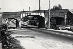
Railway Trestle
https://search.heritageburnaby.ca/link/archivedescription79485
- Repository
- City of Burnaby Archives
- Date
- September 27, 1976
- Collection/Fonds
- Burnaby Public Library Contemporary Visual Archive Project
- Description Level
- Item
- Physical Description
- 1 photograph : b&w ; 11 x 16 cm mounted on cardboard
- Scope and Content
- Photograph shows the railway trestle on Boundary Road.
- Repository
- City of Burnaby Archives
- Date
- September 27, 1976
- Collection/Fonds
- Burnaby Public Library Contemporary Visual Archive Project
- Physical Description
- 1 photograph : b&w ; 11 x 16 cm mounted on cardboard
- Description Level
- Item
- Record No.
- 556-317
- Access Restriction
- No restrictions
- Reproduction Restriction
- Reproduce for fair dealing purposes only
- Accession Number
- 2013-13
- Scope and Content
- Photograph shows the railway trestle on Boundary Road.
- Subjects
- Transportation - Rail
- Media Type
- Photograph
- Photographer
- Norton, Paul
- Notes
- Scope note taken directly from BPL photograph description.
- 1 b&w copy negative : 10 x 12.5 cm accompanying
- Geographic Access
- Boundary Road
Images

Smitty's Restaurant
https://search.heritageburnaby.ca/link/archivedescription79331
- Repository
- City of Burnaby Archives
- Date
- September 5, 1976
- Collection/Fonds
- Burnaby Public Library Contemporary Visual Archive Project
- Description Level
- Item
- Physical Description
- 1 photograph : b&w ; 11 x 16 cm mounted on cardboard
- Scope and Content
- Photograph shows a sign advertising Smitty's restaurant with smaller "Welcome to Burnaby" sign below, on Hastings Street near Boundary Road. A transmission tower is on the right.
- Repository
- City of Burnaby Archives
- Date
- September 5, 1976
- Collection/Fonds
- Burnaby Public Library Contemporary Visual Archive Project
- Physical Description
- 1 photograph : b&w ; 11 x 16 cm mounted on cardboard
- Description Level
- Item
- Record No.
- 556-246
- Access Restriction
- No restrictions
- Reproduction Restriction
- Reproduce for fair dealing purposes only
- Accession Number
- 2013-13
- Scope and Content
- Photograph shows a sign advertising Smitty's restaurant with smaller "Welcome to Burnaby" sign below, on Hastings Street near Boundary Road. A transmission tower is on the right.
- Names
- Smitty's Restaurant
- Media Type
- Photograph
- Notes
- Scope note taken directly from BPL photograph description.
- 1 b&w copy negative : 10 x 12.5 cm accompanying
- Photographers identified by surnames only: Carr and Vardeman
- Geographic Access
- Hastings Street
- Boundary Road
- Historic Neighbourhood
- Vancouver Heights (Historic Neighbourhood)
- Planning Study Area
- Willingdon Heights Area
Images
