Narrow Results By
Decade
- 2020s
- 2010s 4301
- 2000s 7774
- 1990s 10822
- 1980s 10041
- 1970s 14614
- 1960s 10665
- 1950s 9053
- 1940s 5586
- 1930s 5860
- 1920s 9635
- 1910s 7018
- 1900s 3174
- 1890s 1482
- 1880s 158
- 1870s 77
- 1860s 124
- 1850s
- 1840s 7
- 1830s 6
- 1820s 6
- 1810s 3
- 1800s 3
- 1790s 2
- 1780s 2
- 1770s 2
- 1760s 2
- 1750s 2
- 1740s 2
- 1730s
- 1720s 2
- 1710s 2
- 1700s 2
- 1690s 2
- 1680s 2
- 1670s 1
- 1660s 1
- 1650s 1
- 1640s 1
- 1630s 1
- 1620s 1
- 1610s 1
- 1600s 1
- 1590s 1
- 1580s 1
- 1570s 1
- 1560s 1
- 1550s 1
- 1540s 1
- 1530s 1
- 1520s 1
- 1510s 1
- 1500s 1
- 1490s 1
- 1480s 1
Subject
- Advertising Medium - Signs and Signboards 33
- Buildings - Civic - Hospitals 1
- Buildings - Civic - Libraries 1
- Buildings - Commercial 5
- Buildings - Commercial - Drugstores 1
- Buildings - Commercial - Grocery Stores 10
- Buildings - Commercial - Malls 2
- Buildings - Commercial - Offices 1
- Buildings - Commercial - Restaurants 4
- Buildings - Commercial - Service Stations 1
- Buildings - Commercial - Stores 1
- Buildings - Heritage 1

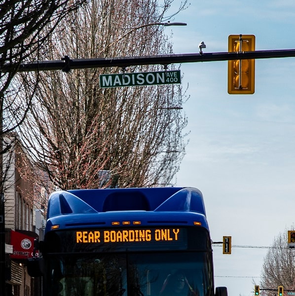
Bus Practices
https://search.heritageburnaby.ca/link/archivedescription95126
- Repository
- City of Burnaby Archives
- Date
- April 10, 2020
- Collection/Fonds
- Burnaby Photographic Society fonds
- Description Level
- Item
- Physical Description
- 1 photograph (tiff)
- Scope and Content
- Photograph of the destination sign on a bus at East Hastings Street and Madison Avenue that reads "Rear Boarding Only".
- Repository
- City of Burnaby Archives
- Date
- April 10, 2020
- Collection/Fonds
- Burnaby Photographic Society fonds
- Physical Description
- 1 photograph (tiff)
- Description Level
- Item
- Record No.
- 623-044
- Access Restriction
- No restrictions
- Reproduction Restriction
- Reproduce for fair dealing purposes only
- Accession Number
- 2020-10
- Scope and Content
- Photograph of the destination sign on a bus at East Hastings Street and Madison Avenue that reads "Rear Boarding Only".
- Subjects
- Transportation - Buses
- Media Type
- Photograph
- Photographer
- Jerome, Ron
- Notes
- Transcribed title
- Geographic Access
- Hastings Street
- Madison Avenue
- Historic Neighbourhood
- Vancouver Heights (Historic Neighbourhood)
- Planning Study Area
- Burnaby Heights Area
Images

Canadian Food Market
https://search.heritageburnaby.ca/link/archivedescription98666
- Repository
- City of Burnaby Archives
- Date
- 2022
- Collection/Fonds
- Disappearing Burnaby collection
- Description Level
- Item
- Physical Description
- 1 photograph (jpeg) : col.
- Scope and Content
- Photograph of the exterior of the Canadian Food Market, taken from across Imperial Street at night. The grocery store is located at 4378 Imperial Street and the building was constructed in 1962. A large display of plants and flowers stands in front of the store and is illuminated by bright lights.
- Repository
- City of Burnaby Archives
- Date
- 2022
- Collection/Fonds
- Disappearing Burnaby collection
- Physical Description
- 1 photograph (jpeg) : col.
- Description Level
- Item
- Record No.
- 634-013
- Access Restriction
- No restrictions
- Reproduction Restriction
- No restrictions
- Accession Number
- 2022-14
- Scope and Content
- Photograph of the exterior of the Canadian Food Market, taken from across Imperial Street at night. The grocery store is located at 4378 Imperial Street and the building was constructed in 1962. A large display of plants and flowers stands in front of the store and is illuminated by bright lights.
- Media Type
- Photograph
- Photographer
- Cheung, Nakita
- Notes
- Title taken from the associated blog post
- Associated blog post: https://disappearingburnaby.wordpress.com/2022/02/20/imperial-manor-2/
- Geographic Access
- Imperial Street
- Street Address
- 4378 Imperial Street
- Historic Neighbourhood
- Central Park (Historic Neighbourhood)
- Planning Study Area
- Sussex-Nelson Area
Images


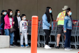
Cash till line up
https://search.heritageburnaby.ca/link/archivedescription95107
- Repository
- City of Burnaby Archives
- Date
- April 27, 2020
- Collection/Fonds
- Burnaby Photographic Society fonds
- Description Level
- Item
- Physical Description
- 1 photograph (tiff)
- Scope and Content
- Photograph of shoppers in the checkout lines at Save-On-Foods grocery store at the Old Orchard Shopping Centre. On the floor are red decals indicating where shoppers should stand to maintain distance from one another. The decals read: "Allow 2M between shoppers".
- Repository
- City of Burnaby Archives
- Date
- April 27, 2020
- Collection/Fonds
- Burnaby Photographic Society fonds
- Physical Description
- 1 photograph (tiff)
- Description Level
- Item
- Record No.
- 623-025
- Access Restriction
- No restrictions
- Reproduction Restriction
- No restrictions
- Accession Number
- 2020-10
- Scope and Content
- Photograph of shoppers in the checkout lines at Save-On-Foods grocery store at the Old Orchard Shopping Centre. On the floor are red decals indicating where shoppers should stand to maintain distance from one another. The decals read: "Allow 2M between shoppers".
- Media Type
- Photograph
- Photographer
- Snowdon, Nick
- Notes
- Transcribed title
- Photographer's caption: "Physical distancing signs become common in most stores"
- Geographic Access
- Kingsway
- Street Address
- 4429 Kingsway
- Historic Neighbourhood
- Central Park (Historic Neighbourhood)
- Planning Study Area
- Garden Village Area
Images


Central Park testing station
https://search.heritageburnaby.ca/link/archivedescription95101
- Repository
- City of Burnaby Archives
- Date
- May 9, 2020
- Collection/Fonds
- Burnaby Photographic Society fonds
- Description Level
- Item
- Physical Description
- 1 photograph (tiff)
- Scope and Content
- Photograph of the COVID-19 testing station located in the Central Park parking lot off Boundary Road. A sign in the foreground reads "Covid-19 Care Site by Referral Only / Walk in Access". In the background, the white tents of the testing station are visible.
- Repository
- City of Burnaby Archives
- Date
- May 9, 2020
- Collection/Fonds
- Burnaby Photographic Society fonds
- Physical Description
- 1 photograph (tiff)
- Description Level
- Item
- Record No.
- 623-019
- Access Restriction
- No restrictions
- Reproduction Restriction
- No restrictions
- Accession Number
- 2020-10
- Scope and Content
- Photograph of the COVID-19 testing station located in the Central Park parking lot off Boundary Road. A sign in the foreground reads "Covid-19 Care Site by Referral Only / Walk in Access". In the background, the white tents of the testing station are visible.
- Subjects
- Geographic Features - Parks
- Geographic Features - Automobile Parking Lots
- Advertising Medium - Signs and Signboards
- Structures - Tents
- Media Type
- Photograph
- Photographer
- Damer, Eric
- Notes
- Transcribed title
- Geographic Access
- Boundary Road
- Central Park
- Historic Neighbourhood
- Central Park (Historic Neighbourhood)
- Planning Study Area
- Maywood Area
Images


Charmwood Apartments
https://search.heritageburnaby.ca/link/archivedescription98661
- Repository
- City of Burnaby Archives
- Date
- 2022
- Collection/Fonds
- Disappearing Burnaby collection
- Description Level
- Item
- Physical Description
- 1 photograph (jpeg) : col.
- Scope and Content
- Photograph of the entrance to Charmwood Apartments, a low-rise apartment building located at 6558 Sussex Avenue. The building was constructed in 1964. The photograph depicts the building at night; building's stairwell and lobby are visible from the lights shining through the windows.
- Repository
- City of Burnaby Archives
- Date
- 2022
- Collection/Fonds
- Disappearing Burnaby collection
- Physical Description
- 1 photograph (jpeg) : col.
- Description Level
- Item
- Record No.
- 634-008
- Access Restriction
- No restrictions
- Reproduction Restriction
- No restrictions
- Accession Number
- 2022-14
- Scope and Content
- Photograph of the entrance to Charmwood Apartments, a low-rise apartment building located at 6558 Sussex Avenue. The building was constructed in 1964. The photograph depicts the building at night; building's stairwell and lobby are visible from the lights shining through the windows.
- Media Type
- Photograph
- Photographer
- Cheung, Nakita
- Notes
- Title taken from the associated blog post
- Associated blog post: https://disappearingburnaby.wordpress.com/2022/03/12/charmwood-apts/
- Geographic Access
- Sussex Avenue
- Street Address
- 6558 Sussex Avenue
- Historic Neighbourhood
- Central Park (Historic Neighbourhood)
- Planning Study Area
- Maywood Area
Images


Cheap Gas during Covid Pandemic
https://search.heritageburnaby.ca/link/archivedescription95087
- Repository
- City of Burnaby Archives
- Date
- April 27, 2020
- Collection/Fonds
- Burnaby Photographic Society fonds
- Description Level
- Item
- Physical Description
- 1 photograph (tiff)
- Scope and Content
- Photograph of a Chevron Gas Station sign advertising gas for 85.9 cents per litre. The Chevron station is located at 6138 Kingsway.
- Repository
- City of Burnaby Archives
- Date
- April 27, 2020
- Collection/Fonds
- Burnaby Photographic Society fonds
- Physical Description
- 1 photograph (tiff)
- Description Level
- Item
- Record No.
- 623-006
- Access Restriction
- No restrictions
- Reproduction Restriction
- Reproduce for fair dealing purposes only
- Accession Number
- 2020-10
- Scope and Content
- Photograph of a Chevron Gas Station sign advertising gas for 85.9 cents per litre. The Chevron station is located at 6138 Kingsway.
- Media Type
- Photograph
- Photographer
- Asbia, Cher
- Notes
- Transcribed title
- Photographer's caption: "Huge drop in gas prices for a few weeks only"
- Geographic Access
- Kingsway
- Street Address
- 6138 Kingsway
- Planning Study Area
- Clinton-Glenwood Area
Images

City Council and Office of the City Clerk fonds
https://search.heritageburnaby.ca/link/archivedescription29
- Repository
- City of Burnaby Archives
- Date
- 1892-2021
- Collection/Fonds
- City Council and Office of the City Clerk fonds
- Description Level
- Fonds
- Physical Description
- 130m of textual records and other material
- Scope and Content
- Fonds consists of records generated in the course of municipal business by City Council and the Office of the City Clerk.
- Repository
- City of Burnaby Archives
- Date
- 1892-2021
- Collection/Fonds
- City Council and Office of the City Clerk fonds
- Physical Description
- 130m of textual records and other material
- Description Level
- Fonds
- Access Restriction
- Subject to FOIPPA
- Scope and Content
- Fonds consists of records generated in the course of municipal business by City Council and the Office of the City Clerk.
- History
- The City of Burnaby covers an area of approximately 98 square kilometers between the cities of Vancouver to the west, and Coquitlam and New Westminster to the east, Burrard Inlet to the north, and the Fraser River to the south. The municipality derived its name from Robert Burnaby, a prominent businessman and advisor to Sir James Douglas, the first Governor of the Crown Colony of British Columbia. Burnaby’s early development was closely tied to the development of the City of New Westminster. New Westminster became British Columbia’s capital in 1859, the year after the British Government proclaimed the establishment of British Columbia. Shortly thereafter, the Royal Engineers began exploring Burnaby to establish military defenses and secure natural resources. This involved the construction of a road linking New Westminster to Burrard Inlet for military purposes, which is present-day North Road. At this time, individuals and families began settling in Burnaby and were largely involved in agricultural and logging activities. Burnaby developed slowly until 1887, when the Canadian Pacific Railway was extended into Vancouver from the Port Moody terminal, causing a dramatic increase in traffic between New Westminster and Vancouver. To meet the new transportation demands, a tramline was built in 1891 connecting the two urban centers along what is now Kingsway. The creation and location of the tramline induced property owners to begin subdividing and selling their lands as early as October 1891. The property taxes the roughly 200 residents paid at this time went directly to the provincial government in Victoria. No local services were provided in turn, which prompted the formation of a committee to petition the provincial government for a municipal charter. As a result, the Corporation of the District of Burnaby was incorporated by letters patent on September 22, 1892. Burnaby’s first Council was elected by acclamation on October 15, 1892 and consisted of Reeve Charles R. Shaw and councillors William Brenchley, Arthur De Windt Hazard, L. Claude Hill, William McDermott, and John Woolard.* The first formal Council election was conducted three months later. Nicolai Shou became the first elected reeve of Burnaby by ballot. Council met at various locations, including the tramline’s power house, private homes, and offices until the first municipal hall was built at Kingsway and Edmonds in 1899. Council is ultimately responsible for the government of the City of Burnaby. The Mayor (formally called “Reeve” prior to 1968) and Council are elected by the residents of Burnaby to represent them in decisions with respect to the provision of public services and facilities. Additionally, the Mayor represents the citizens of Burnaby at various public functions and events. Burnaby was without Council representation during most of the Great Depression and part of the Second World War. Council was disbanded on December 31, 1932 as a result of financial difficulties. The Provincial Government appointed a Commissioner to take over the duties of Reeve and Council beginning in 1933. This system of government was retained until January 1943, when Burnaby residents could once again elect their local government officials. The following individuals have served as Mayor (or Reeve) of Burnaby: Charles R. Shaw 1892 Nicolai C. Schou 1893-1903 Charles F. Sprott 1904-1905 Peter Byrne 1906-1910 John W. Weart 1911-1912 Duncan C. McGregor 1913 Hugh M. Fraser 1914-1918 Thomas Sanderson 1919-1920 Alexander K. McLean 1921-1926; 1928-1929 Charles C. Bell 1927 William L. Burdick 1929 William A. Pritchard 1930-1932 William Tate Wilson 1943-1944 George A. Morrison 1945-1949 William R. Beamish 1950-1953 Charles W. MacSorley 1954-1957 Alan H. Emmott 1958-1968 Robert W. Prittie 1969-1973 Thomas W. Constable 1973-1979 David M. Mercier 1979-1981 William A. Lewarne 1981-1987 William J. Copeland 1987-1996 Douglas P. Drummond 1996-2002 Derek R. Corrigan 2002-2018 Mike Hurley 2018-present The following individuals have served as provincially appointed Commissioners for the Corporation of the District of Burnaby: John Bennett 1933 John Mahony 1933-1934 Hugh M. Fraser 1934-1940* R.S. Gilchrist 1941-1942* B.C. Bracewell 1942* *Richard Bolton was Acting Commissioner for most of 1940-1942. He refused to be a full-fledged Commissioner. Closely associated with the functions of Council is the City Clerk. The Office of the City Clerk is responsible for the statutory duties of the municipal clerk including the preparation and preservation of all minutes books and records of Council business, custody of City bylaws, administrative support to Council and its Committees, preparation of Council and Committee agendas and the conduct of local government elections. The Clerk’s Office is the communications link between Council and other City Departments and the general public, and provides assistance and advice to citizens with respect to Council and Council Committee processes, reporting procedures and decisions. At the time of Burnaby’s incorporation in 1892, the municipal Clerk had the responsibility to attend all meetings of Council, keep all records of Council, prepare and alter voters’ lists, conduct Council elections, collect revenue, as well as having the responsibility to prepare balance sheets and audits. An advertisement in a local newspaper for the appointment of the Clerk dated February 1, 1905 states the “united offices of clerk, collector and assessor” receive a salary of $65.00 per month. Originally the treasurer, assessor and records manager for the corporation, the Clerk eventually became the municipal Council liaison. The primary functions of the City Clerk over time have been the keeping of minutes for the meetings of City Council and related bodies; keeping the records of the City of Burnaby as required by the Local Government Act (formally Municipal Act); keeping all records related to City Council decision making; carrying out correspondence on behalf of Council; assembling voters’ lists and carrying out elections; providing communication, information, and public relations services, including responsibility for civic ceremonies/events, and the municipal archives. The following individuals have served as City Clerk: Alexander Philip 1892–1894 Alfred Smither 1894–1899 F.J.H. Shirley 1899–1901 Arthur De Windt Haszard 1901–1902 Walter J. Walker 1902–1905 Benjamin George Walker 1905–1908 Charles Thomas Saunders 1908–1911 W.M. Griffiths 1911–1912 Arthur G. Moore 1912–1933 Charles Boyer Brown 1933–1959 John H. Shaw 1959–1973* James Hudson 1974–1984 Charles A. Turpin 1984–1995 Debbie R. Comis 1995–2011 Anne Skipsey (Acting) 2011-2012 Maryann Manuel (Acting) 2012-2014 Dennis Back 2014-2018 Kate O'Connell 2018-2020 Blanka Zeinabova 2020-2022 *Deputy City Clerk T. Ward took over many of the Clerk’s duties from 1972 to 1973 due to Shaw’s ill health during these years.
- Formats
- Microforms exist for some records. See series descriptions.
- Media Type
- Textual Record
- Creator
- City of Burnaby
- Notes
- Title based on creators of fonds

Civic Protocols
https://search.heritageburnaby.ca/link/archivedescription95104
- Repository
- City of Burnaby Archives
- Date
- April 30, 2020
- Collection/Fonds
- Burnaby Photographic Society fonds
- Description Level
- Item
- Physical Description
- 1 photograph (tiff)
- Scope and Content
- Photograph of a marquee at Burnaby North Secondary School that reads "Wash Your Hands Stay 2M Apart".
- Repository
- City of Burnaby Archives
- Date
- April 30, 2020
- Collection/Fonds
- Burnaby Photographic Society fonds
- Physical Description
- 1 photograph (tiff)
- Description Level
- Item
- Record No.
- 623-022
- Access Restriction
- No restrictions
- Reproduction Restriction
- No restrictions
- Accession Number
- 2020-10
- Scope and Content
- Photograph of a marquee at Burnaby North Secondary School that reads "Wash Your Hands Stay 2M Apart".
- Media Type
- Photograph
- Photographer
- King, Gloria
- Notes
- Transcribed title
- Geographic Access
- Hammarskjold Drive
- Street Address
- 751 Hammarskjold Drive
- Planning Study Area
- Parkcrest-Aubrey Area
Images


Closed ’Til Further Notice
https://search.heritageburnaby.ca/link/archivedescription95130
- Repository
- City of Burnaby Archives
- Date
- April 27, 2020
- Collection/Fonds
- Burnaby Photographic Society fonds
- Description Level
- Item
- Physical Description
- 1 photograph (tiff)
- Scope and Content
- Photograph of the Shadbolt Centre for the Arts' digital marquee on Canada Way, at night. The marquee, which reads "Closed", is brightly illuminated in the dark.
- Repository
- City of Burnaby Archives
- Date
- April 27, 2020
- Collection/Fonds
- Burnaby Photographic Society fonds
- Physical Description
- 1 photograph (tiff)
- Description Level
- Item
- Record No.
- 623-048
- Access Restriction
- No restrictions
- Reproduction Restriction
- Reproduce for fair dealing purposes only
- Accession Number
- 2020-10
- Scope and Content
- Photograph of the Shadbolt Centre for the Arts' digital marquee on Canada Way, at night. The marquee, which reads "Closed", is brightly illuminated in the dark.
- Media Type
- Photograph
- Photographer
- Jerome, Ron
- Notes
- Transcribed title
- Geographic Access
- Deer Lake Avenue
- Street Address
- 6450 Deer Lake Avenue
- Historic Neighbourhood
- Burnaby Lake (Historic Neighbourhood)
- Planning Study Area
- Douglas-Gilpin Area
Images


Coin Counting Machine
https://search.heritageburnaby.ca/link/archivedescription95117
- Repository
- City of Burnaby Archives
- Date
- May 27, 2020
- Collection/Fonds
- Burnaby Photographic Society fonds
- Description Level
- Item
- Physical Description
- 1 photograph (tiff)
- Scope and Content
- Photograph of a coin counter at Vancity Credit Union on Kingsway. Signs taped to the machine state that the machine is closed due to COVID-19 health warnings.
- Repository
- City of Burnaby Archives
- Date
- May 27, 2020
- Collection/Fonds
- Burnaby Photographic Society fonds
- Physical Description
- 1 photograph (tiff)
- Description Level
- Item
- Record No.
- 623-035
- Access Restriction
- No restrictions
- Reproduction Restriction
- No restrictions
- Accession Number
- 2020-10
- Scope and Content
- Photograph of a coin counter at Vancity Credit Union on Kingsway. Signs taped to the machine state that the machine is closed due to COVID-19 health warnings.
- Media Type
- Photograph
- Photographer
- Peterman, Randall
- Notes
- Transcribed title
- Geographic Access
- Kingsway
- Street Address
- 5064 Kingsway
- Historic Neighbourhood
- Central Park (Historic Neighbourhood)
- Planning Study Area
- Marlborough Area
Images

Committee Administration subseries
https://search.heritageburnaby.ca/link/archivedescription96376
- Repository
- City of Burnaby Archives
- Date
- [1960]-2020
- Collection/Fonds
- City Council and Office of the City Clerk fonds
- Description Level
- Subseries
- Physical Description
- 10 folders of textual records + 3 rolls of microfilm
- Scope and Content
- Subseries consists of committee records for the Committee Administration including directories, terms of reference, commissioner appointments, committee applications, successful candidates, and delegations.
- Repository
- City of Burnaby Archives
- Date
- [1960]-2020
- Collection/Fonds
- City Council and Office of the City Clerk fonds
- Series
- Council Committee series
- Subseries
- Committee administration subseries
- Physical Description
- 10 folders of textual records + 3 rolls of microfilm
- Description Level
- Subseries
- Scope and Content
- Subseries consists of committee records for the Committee Administration including directories, terms of reference, commissioner appointments, committee applications, successful candidates, and delegations.
- History
- Committee Administration is responsible for the administrative management of Burnaby's various committees, commissions, and boards.
- Media Type
- Textual Record

Confederation park playground closure
https://search.heritageburnaby.ca/link/archivedescription95102
- Repository
- City of Burnaby Archives
- Date
- April 29, 2020
- Collection/Fonds
- Burnaby Photographic Society fonds
- Description Level
- Item
- Physical Description
- 1 photograph (tiff)
- Scope and Content
- Photograph of a City of Burnaby facility closure sign at Confederation Park. Sign is attached to security fencing closing off the playground equipment at the park.
- Repository
- City of Burnaby Archives
- Date
- April 29, 2020
- Collection/Fonds
- Burnaby Photographic Society fonds
- Physical Description
- 1 photograph (tiff)
- Description Level
- Item
- Record No.
- 623-020
- Access Restriction
- No restrictions
- Reproduction Restriction
- No restrictions
- Accession Number
- 2020-10
- Scope and Content
- Photograph of a City of Burnaby facility closure sign at Confederation Park. Sign is attached to security fencing closing off the playground equipment at the park.
- Media Type
- Photograph
- Photographer
- King, Gloria
- Notes
- Transcribed title
- Geographic Access
- Albert Street
- Confederation Park
- Planning Study Area
- Capitol Hill Area
Images

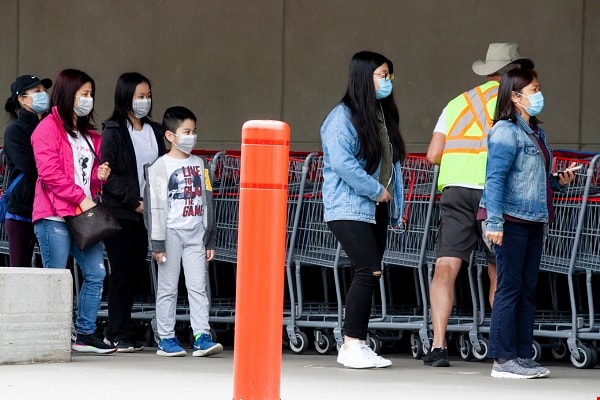
Costco
https://search.heritageburnaby.ca/link/archivedescription95083
- Repository
- City of Burnaby Archives
- Date
- June 13, 2020
- Collection/Fonds
- Burnaby Photographic Society fonds
- Description Level
- Item
- Physical Description
- 1 photograph (tiff)
- Scope and Content
- Photograph of a family waiting in line to enter a Costco store. Everyone in the line is wearing face masks. In the background, an employee in a high visibility vest rearranges shopping carts.
- Repository
- City of Burnaby Archives
- Date
- June 13, 2020
- Collection/Fonds
- Burnaby Photographic Society fonds
- Physical Description
- 1 photograph (tiff)
- Description Level
- Item
- Record No.
- 623-002
- Access Restriction
- No restrictions
- Reproduction Restriction
- No restrictions
- Accession Number
- 2020-10
- Scope and Content
- Photograph of a family waiting in line to enter a Costco store. Everyone in the line is wearing face masks. In the background, an employee in a high visibility vest rearranges shopping carts.
- Media Type
- Photograph
- Photographer
- Gervan, Bonnie
- Notes
- Transcribed title
- Photographer's caption: "A family keeps their distance while waiting to enter the store."
- Geographic Access
- Still Creek Avenue
- Street Address
- 4500 Still Creek Avenue
- Planning Study Area
- Dawson-Delta Area
Images

Costco happy shopper
https://search.heritageburnaby.ca/link/archivedescription95082
- Repository
- City of Burnaby Archives
- Date
- June 13, 2020
- Collection/Fonds
- Burnaby Photographic Society fonds
- Description Level
- Item
- Physical Description
- 1 photograph (tiff)
- Scope and Content
- Photograph of a woman wearing a black face mask, standing with a shopping cart full of groceries in a Costco parking lot.
- Repository
- City of Burnaby Archives
- Date
- June 13, 2020
- Collection/Fonds
- Burnaby Photographic Society fonds
- Physical Description
- 1 photograph (tiff)
- Description Level
- Item
- Record No.
- 623-001
- Access Restriction
- No restrictions
- Reproduction Restriction
- No restrictions
- Accession Number
- 2020-10
- Scope and Content
- Photograph of a woman wearing a black face mask, standing with a shopping cart full of groceries in a Costco parking lot.
- Media Type
- Photograph
- Photographer
- Gervan, Bonnie
- Notes
- Transcribed title
- Photographer's caption: "I asked this friendly woman if I could take her photo, as she was on her way to her car with her groceries."
- Geographic Access
- Still Creek Avenue
- Street Address
- 4500 Still Creek Avenue
- Planning Study Area
- Dawson-Delta Area
Images

Council Committee series
https://search.heritageburnaby.ca/link/archivedescription139
- Repository
- City of Burnaby Archives
- Date
- 1910-2020
- Collection/Fonds
- City Council and Office of the City Clerk fonds
- Description Level
- Series
- Scope and Content
- Series consists of minutes, agendas, correspondence and reports of committees of Council, including the Court of Revision (up to 2001), Advisory Planning Commission, Bicycle Advisory Committee, Civic Development Committee, Community Heritage Commission, Community Housing and Planning Committee, Com…
- Repository
- City of Burnaby Archives
- Date
- 1910-2020
- Collection/Fonds
- City Council and Office of the City Clerk fonds
- Series
- Council Committee series
- Description Level
- Series
- Scope and Content
- Series consists of minutes, agendas, correspondence and reports of committees of Council, including the Court of Revision (up to 2001), Advisory Planning Commission, Bicycle Advisory Committee, Civic Development Committee, Community Heritage Commission, Community Housing and Planning Committee, Community Issues and Social Planning Committee, Community Policing Committee, Emergency Planning Committee, Environment and Waste Management Committee, Executive Committee, Family Court and Youth Justice Committee, Finance and Economics Development Committee, Traffic and Transportation Committee (Traffic Safety Commission), Traffic and Transportation Committee (Transportation and Transit Division), as well as the minutes of various defunct committees.
- History
- Committees of Council are comprised of Council members and citizens of Burnaby who apply to sit on a committee in a volunteer capacity. In the early years, Council committees did not include citizen participation; committees consisted of two or more councillors nominated by the Reeve, or the entire Council would sit as a committee. One councillor would be selected as committee chair. The Reeve would often sit on committees as well. Committees may also be created on an ad hoc basis to deal with particular issues as they arise. For example, a committee was temporarily formed in 1899 to oversee the construction of the new municipal hall. The earliest committees of Council were the Finance Committee, Board of Works, Board of Health and the Licensing Board. Council would also sit once a year as the Court of Revision. [In addition, Councillors also sat on intermunicipal councils with Vancouver and Coquitlam council members]. By 1910, the number of Council committees had increased in accordance with Burnaby’s development; the earliest committee minutes recorded separately from the minutes of Council date from this year.
- Media Type
- Textual Record

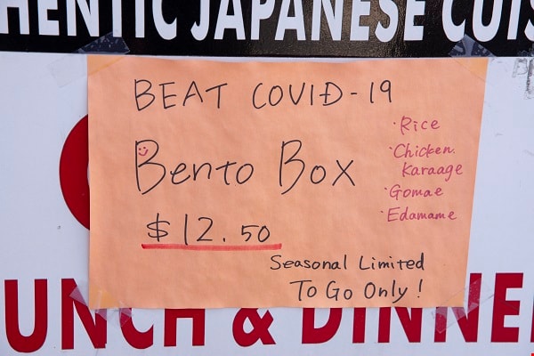
Covid Special
https://search.heritageburnaby.ca/link/archivedescription95127
- Repository
- City of Burnaby Archives
- Date
- April 10, 2020
- Collection/Fonds
- Burnaby Photographic Society fonds
- Description Level
- Item
- Physical Description
- 1 photograph (tiff)
- Scope and Content
- Photograph of a handwritten sign at Kazu Sushi restaurant advertising its bento box special along with the message "Beat COVID-19". The sign is taped to the restaurant's sandwich board.
- Repository
- City of Burnaby Archives
- Date
- April 10, 2020
- Collection/Fonds
- Burnaby Photographic Society fonds
- Physical Description
- 1 photograph (tiff)
- Description Level
- Item
- Record No.
- 623-045
- Access Restriction
- No restrictions
- Reproduction Restriction
- Reproduce for fair dealing purposes only
- Accession Number
- 2020-10
- Scope and Content
- Photograph of a handwritten sign at Kazu Sushi restaurant advertising its bento box special along with the message "Beat COVID-19". The sign is taped to the restaurant's sandwich board.
- Media Type
- Photograph
- Photographer
- Jerome, Ron
- Notes
- Transcribed title
- Geographic Access
- Hastings Street
- Street Address
- 4332 Hastings Street
- Historic Neighbourhood
- Vancouver Heights (Historic Neighbourhood)
- Planning Study Area
- Willingdon Heights Area
Images

Crystal Mall
https://search.heritageburnaby.ca/link/archivedescription95119
- Repository
- City of Burnaby Archives
- Date
- March 25, 2020
- Collection/Fonds
- Burnaby Photographic Society fonds
- Description Level
- Item
- Physical Description
- 1 photograph (tiff)
- Scope and Content
- Photograph of an empty food court at Crystal Mall. All tables are closed off with caution tape and the restaurants are closed.
- Repository
- City of Burnaby Archives
- Date
- March 25, 2020
- Collection/Fonds
- Burnaby Photographic Society fonds
- Physical Description
- 1 photograph (tiff)
- Description Level
- Item
- Record No.
- 623-037
- Access Restriction
- No restrictions
- Reproduction Restriction
- No restrictions
- Accession Number
- 2020-10
- Scope and Content
- Photograph of an empty food court at Crystal Mall. All tables are closed off with caution tape and the restaurants are closed.
- Subjects
- Buildings - Commercial - Malls
- Media Type
- Photograph
- Photographer
- Cheung, Ray
- Notes
- Transcribed title
- Geographic Access
- Kingsway
- Street Address
- 4500 Kingsway
- Historic Neighbourhood
- Central Park (Historic Neighbourhood)
- Planning Study Area
- Maywood Area
Images


Deer Lake parking lot off limits
https://search.heritageburnaby.ca/link/archivedescription95113
- Repository
- City of Burnaby Archives
- Date
- June 26, 2020
- Collection/Fonds
- Burnaby Photographic Society fonds
- Description Level
- Item
- Physical Description
- 1 photograph (tiff)
- Scope and Content
- Photograph of the Deer Lake Park parking lot at the Royal Oak entrance. The entrance to the lot is blocked off with two orange traffic barriers. In the distance, a sign detailing a temporary one-way walking route for the park and a man walking into the park are visible.
- Repository
- City of Burnaby Archives
- Date
- June 26, 2020
- Collection/Fonds
- Burnaby Photographic Society fonds
- Physical Description
- 1 photograph (tiff)
- Description Level
- Item
- Record No.
- 623-031
- Access Restriction
- No restrictions
- Reproduction Restriction
- No restrictions
- Accession Number
- 2020-10
- Scope and Content
- Photograph of the Deer Lake Park parking lot at the Royal Oak entrance. The entrance to the lot is blocked off with two orange traffic barriers. In the distance, a sign detailing a temporary one-way walking route for the park and a man walking into the park are visible.
- Media Type
- Photograph
- Photographer
- Snowdon, Nick
- Notes
- Transcribed title
- Photographer's caption: "Deer Lake parking lots are blocked off for a few months"
- Geographic Access
- Deer Lake Park
- Planning Study Area
- Windsor Area
Images

Disappearing Burnaby collection
https://search.heritageburnaby.ca/link/archivedescription98597
- Repository
- City of Burnaby Archives
- Date
- 2021-2022
- Collection/Fonds
- Disappearing Burnaby collection
- Description Level
- Fonds
- Physical Description
- 33 photographs (jpeg) : b&w and col.
- Scope and Content
- Collection consists of photographs taken by Nakita Cheung for her "Disappearing Burnaby" project, in which she photographs buildings and structures that she finds aesthetically and historically interesting before they are lost to time and/or development in the changing urban landscape of Burnaby. F…
- Repository
- City of Burnaby Archives
- Date
- 2021-2022
- Collection/Fonds
- Disappearing Burnaby collection
- Physical Description
- 33 photographs (jpeg) : b&w and col.
- Description Level
- Fonds
- Access Restriction
- No restrictions
- Reproduction Restriction
- May be restricted by third party rights
- Accession Number
- 2022-14
- Scope and Content
- Collection consists of photographs taken by Nakita Cheung for her "Disappearing Burnaby" project, in which she photographs buildings and structures that she finds aesthetically and historically interesting before they are lost to time and/or development in the changing urban landscape of Burnaby. For this collection, Cheung selected 33 photographs that she felt represented Burnaby in a time of transition. These photographs document single-family homes, low-rise apartment buildings, commercial buildings, signage, and street scenes, often at night and in the rain.
- History
- Nakita Cheung is an amateur photographer located in Burnaby, B.C., near Metrotown. She was born on July 3, 1994, and grew up in Burnaby. In her "Disappearing Burnaby" project, which is also published on her blog "Disappearing Burnaby" (https://disappearingburnaby.wordpress.com), Cheung is creating a "photo journal of Burnaby’s disappearing low-rise apartments, bungalows, and buildings."
- Media Type
- Photograph
- Creator
- Cheung, Nakita

Do Your Part Eagle
https://search.heritageburnaby.ca/link/archivedescription95084
- Repository
- City of Burnaby Archives
- Date
- June 13, 2020
- Collection/Fonds
- Burnaby Photographic Society fonds
- Description Level
- Item
- Physical Description
- 1 photograph (tiff)
- Scope and Content
- Photograph of a sign along the Burnaby Lake Freeway Trail that reads: "Do your part. Stay 2 metres apart." The sign has a silhoutte drawing of an eagle with its wings open to illustrate the distance of two metres.
- Repository
- City of Burnaby Archives
- Date
- June 13, 2020
- Collection/Fonds
- Burnaby Photographic Society fonds
- Physical Description
- 1 photograph (tiff)
- Description Level
- Item
- Record No.
- 623-003
- Access Restriction
- No restrictions
- Reproduction Restriction
- No restrictions
- Accession Number
- 2020-10
- Scope and Content
- Photograph of a sign along the Burnaby Lake Freeway Trail that reads: "Do your part. Stay 2 metres apart." The sign has a silhoutte drawing of an eagle with its wings open to illustrate the distance of two metres.
- Media Type
- Photograph
- Photographer
- Gervan, Bonnie
- Notes
- Transcribed title
- Photographer's caption: "A sign shows how far to keep apart."
- Geographic Access
- Burnaby Lake Regional Nature Park
- Historic Neighbourhood
- Burnaby Lake (Historic Neighbourhood)
- Planning Study Area
- Burnaby Lake Area
Images
