Narrow Results By
Person / Organization
- Burnaby Arts Centre 3
- Burnaby Arts Council 2
- Burnaby Mountain Centennial Rose Garden 1
- Burnaby Mountain Preservation Society 1
- Burnaby South High School 2
- Burnaby Writers' Club 3
- Canadian Institute of Mining and Metallurgy 1
- Canadian Tamil Congress (CTC) 1
- Cliff Avenue United Football Club 1
- Emmott, Alan H 1
- Evans, Alf 2
- Fowler, Rod 16

East Burnaby Neighbourhood
https://search.heritageburnaby.ca/link/landmark712
- Repository
- Burnaby Heritage Planning
- Associated Dates
- 1925-1954
- Heritage Value
- After a lull in construction during the World War I period, East Burnaby Neighbourhood's growth resumed during the 1920s when many homes and businesses were constructed. The post-World War Two period also saw rapid construction and the creation of new housing developments in response to a population boom. The neighbourhood remained a primarily single-family residential area.
- Historic Neighbourhood
- Edmonds (Historic Neighbourhood)
- Planning Study Area
- Stride Avenue Area
Images


Alta Vista Neighbourhood
https://search.heritageburnaby.ca/link/landmark707
- Repository
- Burnaby Heritage Planning
- Associated Dates
- 1925-1954
- Heritage Value
- As with many areas of Burnaby during this period, the years after World War Two marked a rapid growth in residential development in the Alta-Vista Neighbourhood. Subdivisions like Sussex and Suncrest were built and new schools and amenities were constructed to meet the demands of increased population.
- Historic Neighbourhood
- Alta Vista (Historic Neighbourhood)
- Planning Study Area
- Sussex-Nelson Area
Images


Brantford Elementary School
https://search.heritageburnaby.ca/link/landmark809
- Repository
- Burnaby Heritage Planning
- Geographic Access
- Brantford Avenue
- Associated Dates
- 1965
- Heritage Value
- As housing developments extended north from Kingsway, pupil enrolments grew at Windsor and at Morley Schools so Brantford was built equidistant from the two to help ease enrolment problems. Brantford Elementary school opened in 1965 and was similar in structure to other schools built in Burnaby during this period - no basements, no second stories and no high stairways. Classrooms were built in a line and could easily be added to as enrolments increased. Brantford had room additions in 1969.
- Historic Neighbourhood
- Edmonds (Historic Neighbourhood)
- Planning Study Area
- Kingsway-Beresford Area
- Street Address
- 6512 Brantford Avenue
- Street View URL
- Google Maps Street View
Images


Burquitlam Neighbourhood
https://search.heritageburnaby.ca/link/landmark703
- Repository
- Burnaby Heritage Planning
- Associated Dates
- 1925-1954
- Heritage Value
- By the 1950s, the Burquitlam Neighbourhood was becoming a residential and commercial centre for the northeast section of Burnaby. The Sullivan Heights area was developed as a single-family residential area with the Lyndhurst School opening in 1954. The completion of the Lougheed Highway in 1953 encouraged more commercial and retail development and fostered the growth of the neighbourhood throughout this period.
- Historic Neighbourhood
- Burquitlam (Historic Neighbourhood)
- Planning Study Area
- Lyndhurst Area
Images


Central Park Neighbourhood
https://search.heritageburnaby.ca/link/landmark688
- Repository
- Burnaby Heritage Planning
- Associated Dates
- 1925-1954
- Heritage Value
- Although still largely a rural area during the 1920s, subdivisions began appearing in the Central Park neighbourhood at this time. Development was slowed by the Great Depression of the 1930s but the influx of commercial buildings and new housing initiatives in the post-war boom led to a period of rapid growth especially in the Garden Village subdivision which was undertaken in 1953 with the plan to build 500 modern homes in the 140-acre site. Despite the closure of the interurban line in 1953, the neighbourhood remained an active commercial and residential centre.
- Historic Neighbourhood
- Central Park (Historic Neighbourhood)
- Planning Study Area
- Maywood Area
Images


Confederation Park Elementary School
https://search.heritageburnaby.ca/link/landmark786
- Repository
- Burnaby Heritage Planning
- Geographic Access
- Pandora Street
- Associated Dates
- 1965
- Heritage Value
- Confederation Park school was built in 1965 to alleviate increased enrolments in Rosser Avenue and Capitol Hill schools. All elementary schools built in Burnaby in the post-war period share similar features and Confederation Park is no exception. Built low to the ground with no basement, no second stories and no high stairways, the structures could be easily added to as needed as the classrooms were built in a line.
- Historic Neighbourhood
- Capitol Hill (Historic Neighbourhood)
- Planning Study Area
- Capitol Hill Area
- Street Address
- 4715 Pandora Street
- Street View URL
- Google Maps Street View
Images


Douglas-Gilpin Neighbourhood
https://search.heritageburnaby.ca/link/landmark799
- Repository
- Burnaby Heritage Planning
- Associated Dates
- 1955-2008
- Heritage Value
- The Douglas-Gilpin Neighbourhood developed into a diverse area incorporating residential, business, educational and park districts in the period after 1955. The BCIT site was built in the early 1960s, shortly after the Burnaby Municipal Hall was located on Canada Way near Deer Lake in 1956. The construction of the Municipal Hall at this location fostered the creation of an administrative and business centre adjacent to the park, while the northern and central areas of the neighbourhood retained their primarily residential character.
- Historic Neighbourhood
- Burnaby Lake (Historic Neighbourhood)
- Planning Study Area
- Douglas-Gilpin Area
Images


Edmonds Neighbourhood
https://search.heritageburnaby.ca/link/landmark704
- Repository
- Burnaby Heritage Planning
- Associated Dates
- 1925-1954
- Heritage Value
- The historic growth of Edmonds as a neighbourhood was based on its strategic location on the early interurban line between Vancouver and New Westminster. Even by 1980 when a survey of the residential neighbourhoods was conducted, a full 25% of homes in the area predated 1930. The 1950s was a period of strong housing development, with both single-family and multi-family units being constructed. Although Burnaby's City Hall was moved from Kingsway and Edmonds in the early 1950s, Edmonds remained an important centre in the community.
- Historic Neighbourhood
- Edmonds (Historic Neighbourhood)
- Planning Study Area
- Stride Avenue Area
Images


Lozells Neighbourhood
https://search.heritageburnaby.ca/link/landmark701
- Repository
- Burnaby Heritage Planning
- Associated Dates
- 1925-1954
- Heritage Value
- Like a lot of residential neighbourhoods in Burnaby during the post-War boom, the Lozells area during the 1925-1954 period was one of new construction and subdivisions. Although more homes were being built, the neighbourhood still retained a somewhat rural characteristic well into the 1950s.
- Historic Neighbourhood
- Lozells (Historic Neighbourhood)
- Planning Study Area
- Government Road Area
Images


Maywood Elementary School
https://search.heritageburnaby.ca/link/landmark812
- Repository
- Burnaby Heritage Planning
- Geographic Access
- Imperial Street
- Associated Dates
- 1962
- Heritage Value
- Located between Nelson and Suncrest Schools, Maywood Elementary School was built in 1962 and helped eased the increasing enrolments at these other schools. Like other schools of this period, Maywood was built on one level with no basement and no high stairs. The classrooms were built in a line which could be easily added to as required. Additions to the original structure were completed in 1964, 1966, 1967, 1971, 1972. Fires at the school in 1979 and 1989 caused extensive damage and required partial reconstruction of the building.
- Historic Neighbourhood
- Central Park (Historic Neighbourhood)
- Planning Study Area
- Maywood Area
- Street Address
- 4567 Imperial Street
- Street View URL
- Google Maps Street View
Images


Montague & Marcia Moore Residence
https://search.heritageburnaby.ca/link/landmark499
- Repository
- Burnaby Heritage Planning
- Description
- The Montague and Marcia Moore Residence, situated on Sperling Avenue, is a one and one-half storey wood-frame house with Tudor Revival elements such as half-timbering and diamond-leaded windows. The landscaping includes a large hedge at the front of the property. It is located on a lakefront site w…
- Associated Dates
- 1943
- Street View URL
- Google Maps Street View
- Repository
- Burnaby Heritage Planning
- Geographic Access
- Sperling Avenue
- Associated Dates
- 1943
- Description
- The Montague and Marcia Moore Residence, situated on Sperling Avenue, is a one and one-half storey wood-frame house with Tudor Revival elements such as half-timbering and diamond-leaded windows. The landscaping includes a large hedge at the front of the property. It is located on a lakefront site within the scenic Deer Lake Park Heritage Precinct.
- Heritage Value
- Located within the historic Deer Lake Park neighbourhood, the Montague and Marcia Moore Residence is valued as an example of the late persistence of the historicist influence on domestic architecture, at a time when it was still considered the height of good taste for a house to be designed in a recognizable period revival style. This is reflected in the rustic Tudor Revival elements such as half-timbering, waney-edged boards in the gables, brick nogging, diamond-leaded windows, and bird houses in the main gable. The cobblestone chimney, the major focal point of the house, was constructed from river stones that were transported from Lynn Canyon. Meticulously retained in its original condition, this was the last home to be constructed by the Moore family before the Second World War construction supply rationing took effect. It was built by Danish contractor, Hans Jorgensen Hau (1878-1944), who had a flair for the construction of homes with a rustic character, and shares a number of design features with Hau’s own house at 5070 Canada Way.
- Defining Elements
- Key elements that define the heritage character of the Montague and Marcia Moore Residence include its: - location on a lakefront site, within the Deer Lake Park Heritage Precinct - residential form, scale and massing as expressed by its one and one-half storey height, rectangular plan and front gabled roof - wood-frame construction - Tudor Revival elements such as stucco and wood half-timbering, diamond-leaded casement windows, scroll-cut brackets, brick nogging on the front façade, bird houses in the main front gable, waney-edged boards at gable peaks, plank front door with strap hinges and a prominent external cobblestone chimney - associated landscape features such as a granite wall, and mature coniferous and deciduous trees
- Historic Neighbourhood
- Burnaby Lake (Historic Neighbourhood)
- Planning Study Area
- Morley-Buckingham Area
- Organization
- Canadian Institute of Mining and Metallurgy
- Builder
- Hans Jorgensen Hau
- Function
- Primary Historic--Single Dwelling
- Primary Current--Single Dwelling
- Community
- Deer Lake
- Cadastral Identifier
- P.I.D.006-082-696
- Boundaries
- The Montague and Marcia Moore Residence is comprised of a single residential lot located at 5165 Sperling Avenue, Burnaby.
- Area
- 4104
- Contributing Resource
- Building
- Ownership
- Public (local)
- Documentation
- City of Burnaby Planning and Building Department, Heritage Site Files
- Street Address
- 5165 Sperling Avenue
- Street View URL
- Google Maps Street View
Images


Suncrest Neighbourhood
https://search.heritageburnaby.ca/link/landmark839
- Repository
- Burnaby Heritage Planning
- Associated Dates
- 1955-2008
- Heritage Value
- The Suncrest Neighbourhood is a small residential area south of Burnaby's Central Park. The Ocean View Burial Park takes up a large area of land in the north-east corner of this neighbourhood and the majority of the housing was built during the 1930-1960 period.
- Historic Neighbourhood
- Alta Vista (Historic Neighbourhood)
- Planning Study Area
- Suncrest Area
Images


Vancouver Heights Neighbourhood
https://search.heritageburnaby.ca/link/landmark666
- Repository
- Burnaby Heritage Planning
- Associated Dates
- 1925-1954
- Heritage Value
- Vancouver Heights remained an important residential and commercial centre in Burnaby throughout the 1925-1954 period. The area had its own Board of Trade and the North Burnaby Library was created to serve the residents. In 1949, the Hastings streetcars stopped running, but the area retained its reputation as one of the best shopping districts in the city.
- Historic Neighbourhood
- Vancouver Heights (Historic Neighbourhood)
- Planning Study Area
- Burnaby Heights Area
Images


Willingdon Heights Neighbourhood
https://search.heritageburnaby.ca/link/landmark777
- Repository
- Burnaby Heritage Planning
- Associated Dates
- 1955-2008
- Heritage Value
- The convenient location of Willingdon Heights to the Trans Canada Highway, Lougheed Highway and Hastings Street has fostered its development as a primarily residential commuter neighbourhood. Characterised in the post-World War Two period by predominantly single-family developments, the neighbourhood has retained this identity despite some higher density apartment buildings now found there.
- Planning Study Area
- Willingdon Heights Area
Images


History of Burnaby and vicinity
https://search.heritageburnaby.ca/link/museumlibrary6890
- Repository
- Burnaby Village Museum
- Author
- Green, George, 1872-1955
- Publication Date
- 1947
- Call Number
- 971.133 GRE Copy 2 Ver. 1
- Repository
- Burnaby Village Museum
- Collection
- Digital Reference Collection
- Special Collection
- Material Type
- Book
- Accession Code
- BV017.17.1
- Call Number
- 971.133 GRE Copy 2 Ver. 1
- Author
- Green, George, 1872-1955
- Place of Publication
- [S.l.]
- Publisher
- [s.n.]
- Publication Date
- 1947
- Printer
- Shoemaker , McLean & Veitch
- Physical Description
- 233 p. : ill., maps, ports. ; 23 cm.
- Inscription
- "Presented To my valued fried Rev. D. W. Scott. a former neighbor at Capitol Hill with best wishes of the author George Green Victoria March 1 1947" [handwritten in black ink on page opposing front pastedown] "BMMM-WU SIGNED 1st ED 50.00" [handwritten in pencil on page opposing front pastedown]
- Library Subject (LOC)
- Burnaby (B.C.)--History
- Burnaby (B.C.)
- Biography
- Name Access
- Green, George
- Notes
- Autographed by author
- "By George Green, pioneer resident of Burnaby, and an ex-Councillor. Charter Member of the British Columbia Historical Association, Vancouver Branch, and an Executive Member."
- Copy 2 of 2
Images

Digital Books
![Application for enlistment or appointment to RCAF during transition period, [1945] thumbnail](/media/hpo/_Data/_BVM_Textual_Records/2019/2019_0040_0041_001.jpg?width=280)
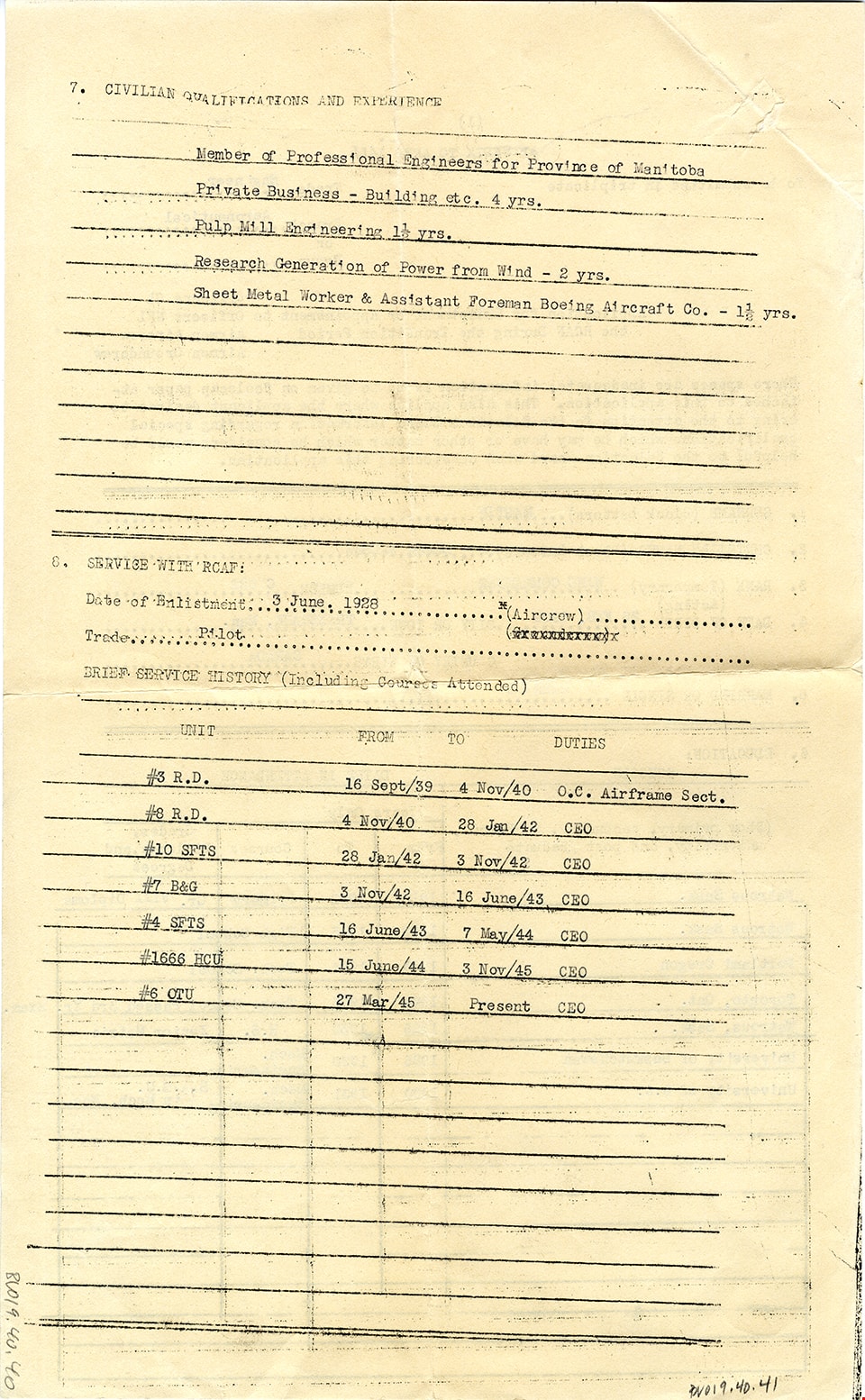
Application for enlistment or appointment to RCAF during transition period
https://search.heritageburnaby.ca/link/museumdescription15108
- Repository
- Burnaby Village Museum
- Date
- [1945]
- Collection/Fonds
- Elmer Wilson Martin fonds
- Description Level
- Item
- Physical Description
- 2 p. (one page double sided)
- Scope and Content
- Item consists of Appendix to Afro 1455 - Application for Enlistment or Appointment to RCAF during the Transition period issued to Elmer Wilson Martin, Wing Commander, Number C 522. Application includes Martin's education, civilian qualifications and brief service history with RCAF, other education,…
- Repository
- Burnaby Village Museum
- Collection/Fonds
- Elmer Wilson Martin fonds
- Description Level
- Item
- Physical Description
- 2 p. (one page double sided)
- Scope and Content
- Item consists of Appendix to Afro 1455 - Application for Enlistment or Appointment to RCAF during the Transition period issued to Elmer Wilson Martin, Wing Commander, Number C 522. Application includes Martin's education, civilian qualifications and brief service history with RCAF, other education, honours and awards and special qualifications.
- Accession Code
- BV019.40.41
- Access Restriction
- No restrictions
- Reproduction Restriction
- May be restricted by third party rights
- Date
- [1945]
- Media Type
- Textual Record
- Scan Resolution
- 600
- Scan Date
- February 8, 2021
- Scale
- 100
- Notes
- Title based on contents of item
Images
![Application for enlistment or appointment to RCAF during transition period, [1945] thumbnail](/media/hpo/_Data/_BVM_Textual_Records/2019/2019_0040_0041_001.jpg)
![Burnaby South High School, [1930]. Item no. 280-008 thumbnail](/media/hpo/_Data/_Archives_Images/_Unrestricted/251/280-008.jpg?width=280)
Interview with Catherine Rees March 14, 1990 - Track 3
https://search.heritageburnaby.ca/link/oralhistory186
- Repository
- City of Burnaby Archives
- Date Range
- 1929-1964
- Length
- 0:08:19
- Summary
- This portion of the interview pertains to Catherine Bertha "Cathy" Rees's memories of the sports activities and other recreational activities that took place while teaching at Burnaby South High School.
- Repository
- City of Burnaby Archives
- Summary
- This portion of the interview pertains to Catherine Bertha "Cathy" Rees's memories of the sports activities and other recreational activities that took place while teaching at Burnaby South High School.
- Date Range
- 1929-1964
- Photo Info
- Burnaby South High School, [1930]. Item no. 280-008
- Length
- 0:08:19
- Subjects
- Recreational Activities
- Geographic Access
- Southoaks Crescent
- Historic Neighbourhood
- Edmonds (Historic Neighbourhood)
- Planning Study Area
- Kingsway-Beresford Area
- Interviewer
- Evans, Alf
- Interview Date
- March 14, 1990
- Scope and Content
- Recording is of an interview with Catherine Bertha "Cathy" Rees by fellow Burnaby Retired Teacher's Association member Alf Evans, March 14, 1990. This interview was prepared for the Burnaby School History Committee of the Burnaby Retired Teacher's Association. Major themes discussed are: the Depression.
- Biographical Notes
- Catherine Bertha “Cathy” Rees was born in Greenwood, British Columbia on March 30, 1903. Her mother died when she was four years old and her younger brother Lloyd was only a few months old. Catherine’s family moved regularly because her dad was continually transferred. She attended a two room school in Greenwood until grade four, then to school in Kamloops until grade 8, graduating from Duke of Connaught High School in New Westminster in 1919. One of her brothers won a lacrosse championship while at Nelson Avenue School. Catherine started at the University of British Columbia in 1919 and went to Normal School in 1923 (she belonged to the first teacher-training class). Upon graduating, Catherine was offered a position at Revelstoke High School for Physics, French and Latin which she took for a brief period of time. She then taught for one year in Victoria, traveling from one school to the other in a one ton truck to teach languages. For the next two years, she worked at Cloverdale High School. By 1929 Catherine began working in Burnaby where her father and two brothers were living. She taught at Burnaby South for her entire career in Burnaby, from 1929 to 1964. Catherine taught French and Latin as well as physical education to the girls (in the basement with two other teachers) and lived at the corner of Nelson and Victory (she still lives there at the time of this interview).
- Total Tracks
- 4
- Total Length
- 0:37:02
- Interviewee Name
- Rees, Catherine "Cathy"
- Collection/Fonds
- Burnaby Historical Society fonds
- Subseries
- Burnaby Retired Teachers subseries
- Media Type
- Sound Recording
Images
![Burnaby South High School, [1930]. Item no. 280-008 thumbnail](/media/hpo/_Data/_Archives_Images/_Unrestricted/251/280-008.jpg)
Audio Tracks
Track three of interview with Catherine Rees
Track three of interview with Catherine Rees
https://search.heritageburnaby.ca/media/hpo/_Data/_Archives_Oral_Histories/_Unrestricted/MSS103-026/MSS103-026_Track_3.mp3
Interview with Catherine Rees March 14, 1990 - Track 4
https://search.heritageburnaby.ca/link/oralhistory187
- Repository
- City of Burnaby Archives
- Date Range
- 1929-1964
- Length
- 0:10:03
- Summary
- This portion of the interview pertains to Catherine Bertha "Cathy" Rees's strongest memories of teaching at Burnaby South High School.
- Repository
- City of Burnaby Archives
- Summary
- This portion of the interview pertains to Catherine Bertha "Cathy" Rees's strongest memories of teaching at Burnaby South High School.
- Date Range
- 1929-1964
- Photo Info
- Burnaby South High School, [1930]. Item no. 280-008
- Length
- 0:10:03
- Geographic Access
- Southoaks Crescent
- Historic Neighbourhood
- Edmonds (Historic Neighbourhood)
- Planning Study Area
- Kingsway-Beresford Area
- Interviewer
- Evans, Alf
- Interview Date
- March 14, 1990
- Scope and Content
- Recording is of an interview with Catherine Bertha "Cathy" Rees by fellow Burnaby Retired Teacher's Association member Alf Evans, March 14, 1990. This interview was prepared for the Burnaby School History Committee of the Burnaby Retired Teacher's Association. Major themes discussed are: the Depression.
- Biographical Notes
- Catherine Bertha “Cathy” Rees was born in Greenwood, British Columbia on March 30, 1903. Her mother died when she was four years old and her younger brother Lloyd was only a few months old. Catherine’s family moved regularly because her dad was continually transferred. She attended a two room school in Greenwood until grade four, then to school in Kamloops until grade 8, graduating from Duke of Connaught High School in New Westminster in 1919. One of her brothers won a lacrosse championship while at Nelson Avenue School. Catherine started at the University of British Columbia in 1919 and went to Normal School in 1923 (she belonged to the first teacher-training class). Upon graduating, Catherine was offered a position at Revelstoke High School for Physics, French and Latin which she took for a brief period of time. She then taught for one year in Victoria, traveling from one school to the other in a one ton truck to teach languages. For the next two years, she worked at Cloverdale High School. By 1929 Catherine began working in Burnaby where her father and two brothers were living. She taught at Burnaby South for her entire career in Burnaby, from 1929 to 1964. Catherine taught French and Latin as well as physical education to the girls (in the basement with two other teachers) and lived at the corner of Nelson and Victory (she still lives there at the time of this interview).
- Total Tracks
- 4
- Total Length
- 0:37:02
- Interviewee Name
- Rees, Catherine "Cathy"
- Collection/Fonds
- Burnaby Historical Society fonds
- Subseries
- Burnaby Retired Teachers subseries
- Media Type
- Sound Recording
Images
Audio Tracks
Track four of interview with Catherine Rees
Track four of interview with Catherine Rees
https://search.heritageburnaby.ca/media/hpo/_Data/_Archives_Oral_Histories/_Unrestricted/MSS103-026/MSS103-026_Track_4.mp3
Interview with Eileen Kernaghan by Rod Fowler April 10, 1990 - Track 1
https://search.heritageburnaby.ca/link/oralhistory491
- Repository
- City of Burnaby Archives
- Date Range
- 1967-1972
- Length
- 00:05:55
- Summary
- This portion of the interview is about how Eileen Kernaghan became involved with the Burnaby Writers’ Society and, as a representative of this club, a member of the Burnaby Arts Council in Canada’s Centennial Year 1967. She describes how the structure of the Arts Council changed, and its focus on t…
- Repository
- City of Burnaby Archives
- Summary
- This portion of the interview is about how Eileen Kernaghan became involved with the Burnaby Writers’ Society and, as a representative of this club, a member of the Burnaby Arts Council in Canada’s Centennial Year 1967. She describes how the structure of the Arts Council changed, and its focus on the newly acquired Art Centre buildings at Deer Lake
- Date Range
- 1967-1972
- Photo Info
- Eileen Kernaghan standing in front of four poets at the Poetry Pocket Cafe in New Westminster, October 15, 1995. Item no. 535-0014
- Length
- 00:05:55
- Subjects
- Arts
- Persons - Volunteers
- Interviewer
- Fowler, Rod
- Interview Date
- April 10, 1990
- Scope and Content
- Recording is of an interview with Eileen Kernaghan, conducted by Rod Fowler. Eileen Kernaghan was one of eleven participants interviewed as part of the SFU/Burnaby Centennial Committee's oral history series titled, "Voices of Burnaby". The interview is mainly about Eileen Kernaghan’s activities with the Burnaby Writers’ Society and the Burnaby Arts Council, describing the history of these organizations between 1967 and 1990. She describes the financial and other challenges facing the arts community, the various programs initiated by the Arts Council, and the development of the Burnaby Arts Centre facilities at Deer Lake. She also talks about her education, writing career, the Neville Street neighbourhood, and her and her husband’s bookstore business. Ghosts believed to inhabit some of the Arts Centre's heritage buildings are also a topic of conversation. To view “Narrow By” terms for each track expand this description and see “Notes”.
- Biographical Notes
- Eileen Kernaghan was born January 6, 1939, to William Alfred Monk (1910-2003) and Belinda Maude Monk (1908-1996), and grew up on a dairy farm near Grindrod in the North Okanagan. She attended a two room school in Grindrod, completed Junior and Senior High School in Enderby, and at age 17 in 1956, left home to attend UBC. She taught school in the North Okanagan area in the late 1950s, during which time she married her husband Patrick Kernaghan. They moved to Vancouver in 1961, Burnaby in 1963, and settled on Neville Street in the South Slope area in 1966 with their three children. Pat Kernaghan worked at Oakalla Prison as a correctional officer until his retirement in 1988. Eileen and Patrick Kernaghan owned and operated a bookstore on Neville Street from 1987 to 1999. They later moved to New Westminster. Eileen Kernaghan began her writing career at twelve years old with a story published in the Vancouver Sun. After her youngest child began school, with more free time, she started writing again and has become an award winning author of fantasy and science fiction novels. She helped found the Burnaby Writers’ Society in 1967, taught writing workshops, and wrote its popular Newsletter for many years. In 1971 the Society put together a small handbook for BC writers, a venture that was expanded and published by Douglas MacIntyre in 1975 as “The Upper Left-Hand Corner: a writer’s handbook for the Northwest”. The book became a Canadian best-seller. During this same period Eileen Kernaghan began her successful “Grey Isles” trilogy. In 1967 she joined the Burnaby Arts Council, worked as its Coordinator from 1973 to 1984, and was a determined advocate for municipal government support for the arts in Burnaby.
- Total Tracks
- 11
- Total Length
- 1:26:27
- Interviewee Name
- Kernaghan, Eileen
- Interviewer Bio
- Rod Fowler returned to university as a mature student in the 1980s after working about twenty years in the field of economics and computerization in business in England, Europe and Western Canada. He graduated with a BA from SFU in both History and Sociology in 1987, his MA degree in Geography in 1989, and his PhD in Cultural Geography at SFU. He taught courses in Geography, Sociology, History and Canadian Studies at several Lower Mainland colleges, before becoming a full time member of the Geography Department at Kwantlen University College.
- Collection/Fonds
- SFU/Burnaby Centennial Committee fonds
- Transcript Available
- Transcript available
- Media Type
- Sound Recording
- Web Notes
- Interviews were digitized in 2015 allowing them to be accessible on Heritage Burnaby. The digitization project was initiated by the Community Heritage Commission with support from City of Burnaby Council.
Images

Audio Tracks
Track one of interview with Eileen Kernaghan
Track one of interview with Eileen Kernaghan
https://search.heritageburnaby.ca/media/hpo/_Data/_Archives_Oral_Histories/_Unrestricted/MSS187-021/MSS187-021_Track%201.mp3
Interview with Eileen Kernaghan by Rod Fowler April 10, 1990 - Track 2
https://search.heritageburnaby.ca/link/oralhistory492
- Repository
- City of Burnaby Archives
- Date Range
- 1967-1972
- Length
- 00:04:48
- Summary
- This portion of the interview is about how the Arts Council equipped the James Cowan Theatre, with a grand opening in 1971; hired staff, including Directors Byron Johnstad followed by LLoyd Barry, and Coordinators Phyllis Webb followed by Louise Holst; and developed programming and projects such as…
- Repository
- City of Burnaby Archives
- Summary
- This portion of the interview is about how the Arts Council equipped the James Cowan Theatre, with a grand opening in 1971; hired staff, including Directors Byron Johnstad followed by LLoyd Barry, and Coordinators Phyllis Webb followed by Louise Holst; and developed programming and projects such as the Sculpture Garden
- Date Range
- 1967-1972
- Photo Info
- Eileen Kernaghan standing in front of four poets at the Poetry Pocket Cafe in New Westminster, October 15, 1995. Item no. 535-0014
- Length
- 00:04:48
- Subjects
- Arts
- Persons - Volunteers
- Interviewer
- Fowler, Rod
- Interview Date
- April 10, 1990
- Scope and Content
- Recording is of an interview with Eileen Kernaghan, conducted by Rod Fowler. Eileen Kernaghan was one of eleven participants interviewed as part of the SFU/Burnaby Centennial Committee's oral history series titled, "Voices of Burnaby". The interview is mainly about Eileen Kernaghan’s activities with the Burnaby Writers’ Society and the Burnaby Arts Council, describing the history of these organizations between 1967 and 1990. She describes the financial and other challenges facing the arts community, the various programs initiated by the Arts Council, and the development of the Burnaby Arts Centre facilities at Deer Lake. She also talks about her education, writing career, the Neville Street neighbourhood, and her and her husband’s bookstore business. Ghosts believed to inhabit some of the Arts Centre's heritage buildings are also a topic of conversation. To view “Narrow By” terms for each track expand this description and see “Notes”.
- Biographical Notes
- Eileen Kernaghan was born January 6, 1939, to William Alfred Monk (1910-2003) and Belinda Maude Monk (1908-1996), and grew up on a dairy farm near Grindrod in the North Okanagan. She attended a two room school in Grindrod, completed Junior and Senior High School in Enderby, and at age 17 in 1956, left home to attend UBC. She taught school in the North Okanagan area in the late 1950s, during which time she married her husband Patrick Kernaghan. They moved to Vancouver in 1961, Burnaby in 1963, and settled on Neville Street in the South Slope area in 1966 with their three children. Pat Kernaghan worked at Oakalla Prison as a correctional officer until his retirement in 1988. Eileen and Patrick Kernaghan owned and operated a bookstore on Neville Street from 1987 to 1999. They later moved to New Westminster. Eileen Kernaghan began her writing career at twelve years old with a story published in the Vancouver Sun. After her youngest child began school, with more free time, she started writing again and has become an award winning author of fantasy and science fiction novels. She helped found the Burnaby Writers’ Society in 1967, taught writing workshops, and wrote its popular Newsletter for many years. In 1971 the Society put together a small handbook for BC writers, a venture that was expanded and published by Douglas MacIntyre in 1975 as “The Upper Left-Hand Corner: a writer’s handbook for the Northwest”. The book became a Canadian best-seller. During this same period Eileen Kernaghan began her successful “Grey Isles” trilogy. In 1967 she joined the Burnaby Arts Council, worked as its Coordinator from 1973 to 1984, and was a determined advocate for municipal government support for the arts in Burnaby.
- Total Tracks
- 11
- Total Length
- 1:26:27
- Interviewee Name
- Kernaghan, Eileen
- Interviewer Bio
- Rod Fowler returned to university as a mature student in the 1980s after working about twenty years in the field of economics and computerization in business in England, Europe and Western Canada. He graduated with a BA from SFU in both History and Sociology in 1987, his MA degree in Geography in 1989, and his PhD in Cultural Geography at SFU. He taught courses in Geography, Sociology, History and Canadian Studies at several Lower Mainland colleges, before becoming a full time member of the Geography Department at Kwantlen University College.
- Collection/Fonds
- SFU/Burnaby Centennial Committee fonds
- Transcript Available
- Transcript available
- Media Type
- Sound Recording
- Web Notes
- Interviews were digitized in 2015 allowing them to be accessible on Heritage Burnaby. The digitization project was initiated by the Community Heritage Commission with support from City of Burnaby Council.
Images
Audio Tracks
Track two of interview with Eileen Kernaghan
Track two of interview with Eileen Kernaghan
https://search.heritageburnaby.ca/media/hpo/_Data/_Archives_Oral_Histories/_Unrestricted/MSS187-021/MSS187-021_Track%202.mp3