Narrow Results By
Decade
- 2020s 55
- 2010s 85
- 2000s 157
- 1990s 258
- 1980s 460
- 1970s 427
- 1960s 158
- 1950s 82
- 1940s
- 1930s
- 1920s 95
- 1910s 86
- 1900s 44
- 1890s
- 1880s 12
- 1870s 1
- 1860s 1
- 1850s 1
- 1840s 1
- 1830s 1
- 1820s 1
- 1810s 1
- 1800s 1
- 1790s 1
- 1780s 1
- 1770s 1
- 1760s 1
- 1750s 1
- 1740s 1
- 1730s 1
- 1720s
- 1710s 1
- 1700s 1
- 1690s 1
- 1680s 1
- 1670s 1
- 1660s 1
- 1650s 1
- 1640s 1
- 1630s 1
- 1620s 1
- 1610s 1
- 1600s 1
Subject
- Agriculture - Fruit and Berries 2
- Arts 1
- Arts - Paintings 2
- Arts - Sculptures 1
- Buildings - Civic 1
- Buildings - Civic - Community Centres 1
- Buildings - Commercial 2
- Buildings - Commercial - Grocery Stores 3
- Buildings - Commercial - Restaurants 2
- Buildings - Commercial - Service Stations 1
- Buildings - Heritage 4
- Buildings - Industrial - Factories 1
Creator
- Aitkenhead, May 1
- Alexander, William John, 1855-1944 1
- Au, M. Sing, 1906- 1
- Baldwin, Joseph, 1827-1899 1
- Berolzheimer, Ruth, 1886-1965 1
- Binks, James 3
- Brown, Donald N. "Don" 1
- Burnaby Art Gallery 1
- Burnaby Village Museum 9
- Cameron, J. C. (James Chalmers), 1852-1912 2
- City of Burnaby 1
- Damer, Eric 1

Jesse Love House
https://search.heritageburnaby.ca/link/landmark540
- Repository
- Burnaby Heritage Planning
- Description
- The Jesse Love House is a vernacular example of a late Victorian-era wood-frame farmhouse with later Arts and Crafts alterations and additions, that has been relocated to the Burnaby Village Museum. This two-storey house has an L-shaped plan, with a compound gabled roof, overhanging eaves and a lar…
- Associated Dates
- 1893
- Formal Recognition
- Heritage Designation, Community Heritage Register
- Other Names
- Jesse & Martha Love Farmhouse
- Street View URL
- Google Maps Street View
- Repository
- Burnaby Heritage Planning
- Other Names
- Jesse & Martha Love Farmhouse
- Geographic Access
- Deer Lake Avenue
- Associated Dates
- 1893
- Formal Recognition
- Heritage Designation, Community Heritage Register
- Enactment Type
- Bylaw No. 9807
- Enactment Date
- 23/11/1992
- Description
- The Jesse Love House is a vernacular example of a late Victorian-era wood-frame farmhouse with later Arts and Crafts alterations and additions, that has been relocated to the Burnaby Village Museum. This two-storey house has an L-shaped plan, with a compound gabled roof, overhanging eaves and a large wraparound verandah.
- Heritage Value
- The value of the Jesse Love House lies in its comprehensive representation of an early Burnaby farmhouse, and the typical additive growth of a home as the resident family prospered. Jesse Love (1849-1928) and his wife Martha Love (1858-1920) moved to Burnaby in 1893 with their family to start a fruit ranch and market garden on Cumberland Road in the East Burnaby district. Jesse Love was actively involved in community affairs, serving on the Burnaby School Board and also as a District Councillor in 1901 and from 1904-07. The original house was constructed by local builder George Salt and consisted of an entrance hall, dining room, lean-to kitchen, master bedroom and several rooms upstairs. As the family grew and prospered, additions were made to the house including a parlour, more bedrooms upstairs, and a large permanent kitchen. Jesse Love was actively involved in community affairs, and the kitchen became a local gathering spot for political discussion and civic organizations. The verandah, exterior shingle cladding, large windows, running water and electricity were eventually added as well. The heritage value for this house also lies in its interpretive value within the Burnaby Village Museum. The site is an important cultural feature for the interpretation of Burnaby’s heritage to the public. The house was moved to the Burnaby Village Museum in 1988 and both the interior and exterior were restored and interpreted to their 1925 period, including reproduction wallpaper.
- Defining Elements
- The character defining features of the Jesse Love House include its: - irregular form and massing - compound gable roof with cedar shingle cladding - Craftsman-style exterior features such as a shingled exterior and triangular eave brackets - multi-paned double-hung 2-over-2 wooden-sash windows; casement window assemblies with transoms in the Living Room - large wrap-around verandah - interior features such as pressed tin ceilings, original wallpapers and cedar panelled kitchen - reproduction Arts and Crafts parlour document wallpaper and border
- Locality
- Deer Lake Park
- Historic Neighbourhood
- Burnaby Lake (Historic Neighbourhood)
- Planning Study Area
- Morley-Buckingham Area
- Organization
- Burnaby Village Museum
- Builder
- George Salt
- Function
- Primary Current--Museum
- Primary Historic--Single Dwelling
- Community
- Burnaby
- Cadastral Identifier
- P.I.D. No. 011-030-356 Legal Description: Parcel 1, District Lot 79 and District Lot 85, Group 1, New Westminster District, Reference Plan 77594
- Boundaries
- Burnaby Village Museum is comprised of a single municipally-owned property located at 6501 Deer Lake Avenue, Burnaby.
- Area
- 38,488.63
- Contributing Resource
- Building
- Landscape Feature
- Structure
- Ownership
- Public (local)
- Documentation
- Heritage Site Files: PC77000 20. City of Burnaby Planning and Building Department, 4949 Canada Way, Burnaby, B.C., V5G 1M2
- Street Address
- 6501 Deer Lake Avenue
- Street View URL
- Google Maps Street View
Images


Annie Barrett-Lennard Residence
https://search.heritageburnaby.ca/link/landmark559
- Repository
- Burnaby Heritage Planning
- Description
- Residential building.
- Associated Dates
- c.1935
- Street View URL
- Google Maps Street View
- Repository
- Burnaby Heritage Planning
- Geographic Access
- Parker Street
- Associated Dates
- c.1935
- Description
- Residential building.
- Heritage Value
- Built for Annie Barrett-Lennard, this British Arts and Crafts residence has retained many of its original features, such as its stucco and half-timbering exterior with a cat’s slide roof over the front entrance. The steeply-pitched gables, asymmetrical half-massing, leaded windows and pegged joinery are all references to traditional British antecedents.
- Locality
- Capitol Hill
- Historic Neighbourhood
- Capitol Hill (Historic Neighbourhood)
- Planning Study Area
- Parkcrest-Aubrey Area
- Area
- 1227.44
- Contributing Resource
- Building
- Ownership
- Private
- Street Address
- 5450 Parker Street
- Street View URL
- Google Maps Street View
Images


Burnaby South High School
https://search.heritageburnaby.ca/link/landmark770
- Repository
- Burnaby Heritage Planning
- Associated Dates
- 1922-1988
- Street View URL
- Google Maps Street View
- Repository
- Burnaby Heritage Planning
- Geographic Access
- Southoaks Crescent
- Associated Dates
- 1922-1988
- Heritage Value
- Burnaby South and Burnaby North were Burnaby's first high schools. The first rooms of the school were built in 1922 on the same grounds as the Kingsway East Elementary School. In 1940, a two-storey building was erected and additions were made in 1963, 1967 and 1972. Kingsway East closed in 1925 and its buildings were used by the high school for Industrial Arts and Home Economics. In the early 1990s, a new "urban education centre" (Burnaby South/B.C. School for the Deaf) was opened, replacing the old Burnaby South High School.
- Historic Neighbourhood
- Edmonds (Historic Neighbourhood)
- Planning Study Area
- Kingsway-Beresford Area
- Street Address
- 6650 Southoaks Crescent
- Street View URL
- Google Maps Street View
Images


Deer Lake Park
https://search.heritageburnaby.ca/link/landmark692
- Repository
- Burnaby Heritage Planning
- Associated Dates
- 1949
- Heritage Value
- As Burnaby developed into a more urban suburb of Vancouver and New Westminster the Deer Lake area retained much of its rural character. In 1949 Deer Lake park was established on the lake's eastern shore. The relocation of the Municipal Hall in the mid-1950s to the Deer Lake area began the vision of developing an administrative and cultural centre for Burnaby. The opportunity for developing this centre began with the opening of the Arts Centre, Century Gardens and the Burnaby Art Gallery in 1967. This was followed by the development of the Deer Lake Park as Burnaby's primary urban park.
- Historic Neighbourhood
- Burnaby Lake (Historic Neighbourhood)
- Planning Study Area
- Morley-Buckingham Area
- Street View URL
- Google Maps Street View
Images


Joseph & Jane Wintemute House
https://search.heritageburnaby.ca/link/landmark523
- Repository
- Burnaby Heritage Planning
- Description
- The Wintemute House is a large two-storey wood-frame Victorian era country farm house with Victorian Italianate detailing. Designed in a symmetrical Foursquare form, it features a low-pitched hipped roof with deep eaves. Later additions to the rear of the house, and the extensive wraparound veranda…
- Associated Dates
- 1891
- Formal Recognition
- Heritage Designation, Community Heritage Register
- Other Names
- Burnett House
- Street View URL
- Google Maps Street View
- Repository
- Burnaby Heritage Planning
- Other Names
- Burnett House
- Geographic Access
- Berkley Street
- Associated Dates
- 1891
- Formal Recognition
- Heritage Designation, Community Heritage Register
- Enactment Type
- Bylaw No. 6889
- Enactment Date
- 07/03/1977
- Description
- The Wintemute House is a large two-storey wood-frame Victorian era country farm house with Victorian Italianate detailing. Designed in a symmetrical Foursquare form, it features a low-pitched hipped roof with deep eaves. Later additions to the rear of the house, and the extensive wraparound verandah and porte-cochere, were Edwardian era additions. It is located on its original site, in the modern subdivision of Buckingham Heights in southeast Burnaby. The Burnett House is one of the oldest surviving houses in Burnaby.
- Heritage Value
- Built circa 1891, the Joseph and Jane Wintemute House is valued as a representation of the early history of Burnaby and its agricultural origins. Built prior to the civic incorporation of Burnaby in 1892, the house was situated to face Douglas Road (now Canada Way), one of the first roads built to connect the rural farmlands of Burnaby to New Westminster. The original large property has been extensively subdivided and the house is now isolated in a modern subdivision. Designated in 1977, the Wintemute House is also significant as Burnaby's first protected municipal heritage site. The house is valued for its association with Joseph S. Wintemute (1832-1911) and Jane Wintemute (1832-1910), who came to British Columbia from Port Stanley, Ontario in 1865, traveling via the Isthmus of Panama. Joseph Wintemute, a skilled carpenter and contractor by trade, operated the Wintemute Furniture Factory in New Westminster, the first furniture plant established on the mainland of British Columbia. In 1891, he acquired this property, where he set up a cord wood sawmill to supply his factory. Wintemute was likely responsible for the design and construction of this commodious structure, as it was built in an Eastern Canadian style he would have been familiar with. After the lands were cleared of timber, the Wintemutes developed the property into a typical small-scale 'market garden,’ involved in the production of vegetables and fruits, such as strawberries, for sale at the New Westminster City Market. The Wintemute House is additionally significant for its association with the speculative land boom that occurred prior to the First World War, and ongoing suburban subdivision. Charles Gordon, a real estate agent, acquired the Wintemute farm and subdivided the acreage, which he marketed through the People’s Trust Company as 'Montrelynview' and offered this house as a draw prize to lot purchasers. With the collapse of the land boom, the house remained in Gordon’s possession until 1929 when it was purchased by his brother-in-law, Geoffrey Burnett, a local surveyor responsible for many of the original land surveys of Burnaby. David Burnett, Geoffrey's son, requested designation of the house when the family decided to subdivide the remaining 1.4 hectares of property in 1977. Furthermore, the Wintemute House is valued as an excellent example of a Victorian era country farm house, based loosely on the traditional farmhouses seen commonly in nineteenth century Ontario. Designed in a vernacular version of the Victorian Italianate style, the house displays restrained detailing, including several original multi-paned windows notable for their vertical proportions. The house retains many original exterior features, and the original interior layout, although modernized during the Edwardian era, is substantially intact, including finely crafted maple and cedar interior millwork that was produced by the Wintemute Furniture Factory. From 1904 to 1910, Charles Gordon, the second owner, made a number of alterations to the house including the addition of the wrap-around verandah, a porte-cochere and a 7.6 metre by 9 metre billiard room in the Arts and Crafts style, beamed and panelled in Douglas Fir. These later additions and alterations have value in demonstrating the evolution of the house and property and changing tastes at the turn of the nineteenth century.
- Defining Elements
- Key elements that define the heritage character of the Wintemute House include its: - picturesque original setting with views to the North Shore - residential form, scale and massing as expressed by its symmetrical cubic form and two-storey height, with later additions to the rear - Victorian Italianate architectural features such as the vertically-proportioned original windows with vestigial window hoods, low-pitched hipped roof and Classical Revival details such as the corner boards articulated as pilasters - hipped roof with deep boxed eaves - horizontal lapped narrow wooden siding - second storey balcony over front entry - wide wraparound columned verandah with porte-cochere, with square trimmed columns - irregular fenestration: original Victorian era double-hung 6-over-6 wood-sash windows with vertical proportions and segmental arched tops; Edwardian era double-hung 1-over-1 wooden-sash windows; and Edwardian era wooden-sash casement window assemblies with leaded transoms - central front entry with sidelights and transom - multi-paned French doors opening out to verandah - interior features such as its 3.7 metre ceiling height on the main and second floors; the coal grate fireplace with elaborate woodwork and glazed tile surround in the front parlour; five other fireplaces throughout the house; maple and cedar interior millwork; and the Douglas Fir panelled and beamed billiard room with hidden doors, seven-panelled doors, original light fixtures and mouldings - internal red brick chimneys with corbelled caps
- Historic Neighbourhood
- Burnaby Lake (Historic Neighbourhood)
- Planning Study Area
- Morley-Buckingham Area
- Function
- Primary Historic--Single Dwelling
- Primary Current--Single Dwelling
- Community
- Burnaby
- Cadastral Identifier
- 003-297-152
- Boundaries
- The Wintemute House is comprised of a single residential lot located at 7640 Berkley Street, Burnaby.
- Area
- 1566.73
- Contributing Resource
- Building
- Ownership
- Private
- Names
- Wintemute, Joseph
- Street Address
- 7640 Berkley Street
- Street View URL
- Google Maps Street View
Images


Lewis & Millicent Physick Residence
https://search.heritageburnaby.ca/link/landmark616
- Repository
- Burnaby Heritage Planning
- Description
- Residential building.
- Associated Dates
- 1939
- Street View URL
- Google Maps Street View
- Repository
- Burnaby Heritage Planning
- Geographic Access
- Boundary Road North
- Associated Dates
- 1939
- Description
- Residential building.
- Heritage Value
- This modest residence was built for Lewis Baker Physick (1905-1971), a freight dispatcher for B.C. Motor Transport Company who later worked for B.C. Hydro, and Millicent Physick (née Edwards, 1894-1971), a hairdresser, who lived here until their respective deaths. Situated on a terraced lot with stone-clad retaining walls, this home was influenced by the British Arts and Crafts style, which remained popular throughout the 1930s. Such stylistic influence can be seen in the second floor overhang, which is supported by false beams, leaded casement windows and steeply pitched roof and front gable. The roofline is enhanced by a jerkin-headed roof on the front gable. Apart from the addition of a later south elevation extension, the house remains in excellent original condition. Located on an elevated site, this residence has an unobstructed view of downtown Vancouver and Burrard Inlet.
- Locality
- Vancouver Heights
- Historic Neighbourhood
- Vancouver Heights (Historic Neighbourhood)
- Planning Study Area
- Burnaby Heights Area
- Area
- 566.71
- Contributing Resource
- Building
- Ownership
- Private
- Street Address
- 420 Boundary Road North
- Street View URL
- Google Maps Street View
Images


Mary Sutcliffe Residence
https://search.heritageburnaby.ca/link/landmark621
- Repository
- Burnaby Heritage Planning
- Description
- Residential building.
- Associated Dates
- c.1930
- Street View URL
- Google Maps Street View
- Repository
- Burnaby Heritage Planning
- Geographic Access
- Boundary Road North
- Associated Dates
- c.1930
- Description
- Residential building.
- Heritage Value
- Built at a time when historical styles were favoured for domestic construction, this charming cottage residence was built for Mary Seymour Sutcliffe (1870-1959), the wife of retired painter Arthur Sutcliffe (1863-1932). It was inspired by the British Arts and Crafts movement, as displayed in the half-timbering, rounded door hood and the picturesque, jerkin-headed roof with exposed purlins. While this house has a Boundary Road address, the house faces north instead of west, facing an elevated and extraordinary view of Burrard Inlet.
- Locality
- Vancouver Heights
- Historic Neighbourhood
- Vancouver Heights (Historic Neighbourhood)
- Planning Study Area
- Burnaby Heights Area
- Area
- 566.71
- Contributing Resource
- Building
- Ownership
- Private
- Street Address
- 650 Boundary Road North
- Street View URL
- Google Maps Street View
Images


Moore House
https://search.heritageburnaby.ca/link/landmark497
- Repository
- Burnaby Heritage Planning
- Description
- The Moore House is a one-storey, side-gabled house with stepped roof planes and a split-level attached garage. The house faces east, and features distinct river rock porch columns and a large central tapered chimney. It is located within the Deer Lake Park Heritage Precinct, and is adjacent to a re…
- Associated Dates
- 1941
- Formal Recognition
- Community Heritage Register
- Other Names
- Ethel Moore Residence
- Street View URL
- Google Maps Street View
- Repository
- Burnaby Heritage Planning
- Other Names
- Ethel Moore Residence
- Geographic Access
- Sperling Avenue
- Associated Dates
- 1941
- Formal Recognition
- Community Heritage Register
- Enactment Type
- Council Resolution
- Enactment Date
- 26/05/2003
- Description
- The Moore House is a one-storey, side-gabled house with stepped roof planes and a split-level attached garage. The house faces east, and features distinct river rock porch columns and a large central tapered chimney. It is located within the Deer Lake Park Heritage Precinct, and is adjacent to a related house, the Rosalie (Moore) Barrett Residence, built the following year.
- Heritage Value
- The Moore House is significant for its relationship to first owner, Ethel Hutchings Moore (1884-1948), who purchased the property from Maud and Harriet Woodward, two of Deer Lake's first residents. Moore purchased the property with the hopes of introducing her children into the house construction business. This house, built in 1941, borrows its design from a 'California Desert House' built in Carmel a few years earlier. Rendered in traditional materials, this modern style merges comfortably with the rustic British Arts and Crafts tradition of most Deer Lake houses. Unusual for being built during wartime date, it was built at a time when domestic construction was severely curtailed due to shortages of labour and material. It is now owned by the City of Burnaby and is part of the Deer Lake Park Heritage Precinct. The Moore House is significant as a testament to Deer Lake's continued popularity as a residential neighbourhood in the 1940s. Although Burnaby was serviced by a number of transportation links at the time, the increasing availability of automobiles provided improved access to outlying suburbs. Rising real estate prices in Vancouver and New Westminster attracted residents to this neighbourhood because of its relative affordability, central location and beautiful scenery.
- Defining Elements
- Key elements that define the heritage character of the Moore House include its: - location within the Deer Lake Park Heritage Precinct - residential form, scale and massing as expressed by its one-storey height, linear plan, side gabled roof with multiple roof planes and split-level attached garage - wood-frame construction with stucco cladding - river rock porch columns and external tapered chimney - decorative embellishments including scroll-cut stickwork on the rear elevation and waney-edged boards in the gable peaks - wooden-sash casement windows with three-part, horizontal leading - associated landscaping features, including stone wall at the front of the property and coniferous and deciduous trees surrounding the property
- Historic Neighbourhood
- Burnaby Lake (Historic Neighbourhood)
- Planning Study Area
- Morley-Buckingham Area
- Function
- Primary Historic--Single Dwelling
- Primary Current--Single Dwelling
- Community
- Deer Lake
- Cadastral Identifier
- P.I.D. 011-454-521
- Boundaries
- The Moore House is comprised of a single residential lot located at 5145 Sperling Avenue, Burnaby.
- Area
- 993.39
- Contributing Resource
- Building
- Ownership
- Public (local)
- Documentation
- City of Burnaby Planning and Building Department, Heritage Site Files
- Street Address
- 5145 Sperling Avenue
- Street View URL
- Google Maps Street View
Images


Stowe Residence
https://search.heritageburnaby.ca/link/landmark642
- Repository
- Burnaby Heritage Planning
- Description
- Residential building.
- Associated Dates
- 1930
- Street View URL
- Google Maps Street View
- Repository
- Burnaby Heritage Planning
- Geographic Access
- Burris Street
- Associated Dates
- 1930
- Description
- Residential building.
- Heritage Value
- This charming home was built for George Norman Stowe (1885-1955) and his wife Lillian (née Ross) Stowe after they purchased this property from the Municipality of Burnaby in a Depression-era tax sale. George Stowe was a civil engineer with the Provincial Department of Public Works from 1905 until 1950. Inspired by the British Arts and Crafts movement, this stuccoed cottage is notable for its picturesque side gabled roof with sloped eaves, and a jerkin-headed dormer with half-timbering. Multi-paned casement windows are used throughout the house, adding to the picturesque effect. A verandah with a colonnade of pillars on the east side of the home overlooks a ravine.
- Locality
- Burnaby Lake
- Historic Neighbourhood
- Burnaby Lake (Historic Neighbourhood)
- Planning Study Area
- Morley-Buckingham Area
- Area
- 1963.96
- Contributing Resource
- Building
- Ownership
- Private
- Street Address
- 7484 Burris Street
- Street View URL
- Google Maps Street View
Images


Terence & Mary Bodkin Residence
https://search.heritageburnaby.ca/link/landmark643
- Repository
- Burnaby Heritage Planning
- Description
- Residential building.
- Associated Dates
- 1930
- Street View URL
- Google Maps Street View
- Repository
- Burnaby Heritage Planning
- Geographic Access
- Ingleton Avenue North
- Associated Dates
- 1930
- Description
- Residential building.
- Heritage Value
- This British Arts and Crafts residence was built for B.C. Coast Steamship Service seaman Terence William Bodkin (1876-1945) and his wife, Mary Margaret Bodkin (née Horie, 1882-1958), who had married in 1913. Mary, a violin teacher, was born in London and Terrance was from Ireland. The house has retained many of its original features such as its side gabled jerkin-headed roof, half timbering and triple assembly windows, with multi-paned upper sash.
- Locality
- Vancouver Heights
- Historic Neighbourhood
- Vancouver Heights (Historic Neighbourhood)
- Planning Study Area
- Burnaby Heights Area
- Area
- 566.71
- Contributing Resource
- Building
- Ownership
- Private
- Street Address
- 124 Ingleton Avenue North
- Street View URL
- Google Maps Street View
Images


Vancouver Heights Presbyterian Church
https://search.heritageburnaby.ca/link/landmark649
- Repository
- Burnaby Heritage Planning
- Description
- Church building.
- Associated Dates
- 1930
- Street View URL
- Google Maps Street View
- Repository
- Burnaby Heritage Planning
- Geographic Access
- Esmond Avenue
- Associated Dates
- 1930
- Description
- Church building.
- Heritage Value
- This church replaced the first Vancouver Heights Presbyterian Church, which opened in 1911 and later became the Masonic Hall. This site was purchased in 1928, but the new church was not completed until 1930, due to the financial constraints of the Depression era. B.C. Lieutenant-Governor Bruce dedicated the church on Feb. 16, 1931. The building has retained its Classical Revival form and detailing, including its symmetrical design, columns flanking the recessed main entrance and arched windows with keystone detailing. The Vancouver Heights Presbyterian Church was designed by Australian-born architect H.H. Simmonds (1883-1954). After serving in the First World War, Simmonds resumed his local practice, and even during the Depression, his output remained prolific. In the 1920s and 30s, Simmonds was commissioned by the City of Vancouver to replace several pavilions at the Pacific National Exhibition with a consistent grouping of Art Deco buildings including the surviving Livestock Building (1929), Women and Fine Arts Building (1931) and Forum (1933).
- Locality
- Vancouver Heights
- Historic Neighbourhood
- Vancouver Heights (Historic Neighbourhood)
- Planning Study Area
- Burnaby Heights Area
- Architect
- H.H. Simmonds
- Area
- 566.79
- Contributing Resource
- Building
- Ownership
- Private
- Street Address
- 140 Esmond Avenue
- Street View URL
- Google Maps Street View
Images


Bishop Block
https://search.heritageburnaby.ca/link/landmark562
- Repository
- Burnaby Heritage Planning
- Description
- Commercial building.
- Associated Dates
- 1935
- Street View URL
- Google Maps Street View
- Repository
- Burnaby Heritage Planning
- Geographic Access
- Hastings Street
- Associated Dates
- 1935
- Description
- Commercial building.
- Heritage Value
- This one-storey commercial block retains its original division into three retail units. An eclectic Spanish Colonial Revival character is imparted by the use of visor roofs, covered in metal pantiles, that extend over the recessed entries. The stepped parapets are more reminiscent of the Art Deco style. Each of the three retail spaces retains their plate glass display windows. This commercial block was owned in 1939 by Mary J. Bishop of Vancouver.
- Locality
- Vancouver Heights
- Historic Neighbourhood
- Vancouver Heights (Historic Neighbourhood)
- Planning Study Area
- Willingdon Heights Area
- Ownership
- Private
- Street Address
- 3736 Hastings Street
- Street View URL
- Google Maps Street View
Images


Capitol Hill Community Hall
https://search.heritageburnaby.ca/link/landmark563
- Repository
- Burnaby Heritage Planning
- Description
- Public building.
- Associated Dates
- 1948
- Street View URL
- Google Maps Street View
- Repository
- Burnaby Heritage Planning
- Geographic Access
- Howard Avenue
- Associated Dates
- 1948
- Description
- Public building.
- Heritage Value
- The Capitol Hill Community Hall was designed by local architect Harold Cullerne (1890-1976). After Cullerne returned from service during the First World War, he joined J.H. Bowman in a partnership that lasted from 1919 to 1934. After Bowman retired in 1934, Cullerne practiced on his own, continuing to work on schools and institutional buildings, such as the Art Deco Hollywood Theatre in Vancouver. In 1944, Cullerne designed a community hall for Capitol Hill; the scheme was delayed, and redesigned before it was finally built after the end of the Second World War. A simple front gabled roof hall structure, this hall is a monument to community spirit, erected by community members on a volunteer basis, and used for community events for over half a century. The hall replaced two earlier structures, both destroyed by fire, that had served the same purpose.
- Locality
- Capitol Hill
- Historic Neighbourhood
- Capitol Hill (Historic Neighbourhood)
- Planning Study Area
- Capitol Hill Area
- Architect
- Harold Cullerne
- Ownership
- Public (local)
- Street Address
- 361 Howard Avenue
- Street View URL
- Google Maps Street View
Images


Cascades Drive-In Theatre
https://search.heritageburnaby.ca/link/landmark689
- Repository
- Burnaby Heritage Planning
- Geographic Access
- Grandview Highway
- Associated Dates
- 1946
- Heritage Value
- The Cascades Drive-In Theatre was Canada's first drive-in and was started by George and William Steel and Joe and Art Johnson in 1946. Built along Grandview Highway (Canada Way) near Smith Street, the theatre opened on August 30, 1946. In 1977, the theatre was purchased by Don Soutar, Al Chappell and Norm Green and continued to operate until 1980. The property was then redeveloped as Cascades Village - a large condominium complex.
- Historic Neighbourhood
- Broadview (Historic Neighbourhood)
- Planning Study Area
- Cascade-Schou Area
- Street Address
- 4050 Grandview Highway
Images


Speech given by Florence Hart Godwin May 28, 1973 - Track 5
https://search.heritageburnaby.ca/link/oralhistory282
- Repository
- City of Burnaby Archives
- Date Range
- 1898-1917
- Length
- 0:05:22
- Summary
- This portion of the recording pertains to Florence (Hart) Godwin's description of her family's stories of the New Westminster fire. She also mentions B.R. Hill and his three sons, Claude, Frank and Minard Hill.
- Repository
- City of Burnaby Archives
- Summary
- This portion of the recording pertains to Florence (Hart) Godwin's description of her family's stories of the New Westminster fire. She also mentions B.R. Hill and his three sons, Claude, Frank and Minard Hill.
- Date Range
- 1898-1917
- Photo Info
- Arthur Morrow, Kingsley Hart, Florence Hart (later Godwin), and Katherine Maude "Kitty" Hill (later Peers) in the woods at the south side of Deer Lake photographed by W.T. Cooksley [1908]. Item no. HV976.139.3
- Length
- 0:05:22
- Subjects
- Natural Phenomena - Fires
- Interviewer
- Burnaby Arts Council
- Interview Date
- May 28, 1973
- Scope and Content
- Recording is of a speech given by Florence Hart Godwin at a Burnaby Arts Council meeting held May 28, 1973. Major themes discussed are: pioneer families and early residences in the Burnaby Lake District.
- Biographical Notes
- Florence Hart was born in 1898 in New Westminster. Florence first saw Burnaby in April of 1905 on a trip made by horse and buggy from the family home in New Westminster where her father worked as a real estate agent. By 1911, he had built a permanent home for his family in Burnaby, building what is now known as the Hart house and is currently owned by the municipality. Frederick John “Fred” Hart married Alice Chapman in Yale BC on August 13, 1895. They had four children together; Kingsley Chapman born May 27, 1897, Florence Elizabeth born October 23, 1898, and ten years later, Edwyna and Jack. They followed their family nurse, Miss Maude Woodward to Burnaby and purchased thirteen acres of land at Deer Lake to build a summer cottage. Mrs Hill and the children spent the summer months there while Frederick continued working in New Westminster, joining his family on the weekends. Florence Hart attended Douglas Road School before boarding at Crofton House in Vancouver. Kingsley Hart had enlisted in the army on March 23, 1915 when he was only seventeen years old. He was killed in action on September 26, 1916. The Hart family then moved to Kerrisdale, Vancouver. Florence worked at the Carnegie Library. On August 7, 1922 Florence Hart married Harold “Hal” Godwin and moved back to Edmonds in Burnaby where they remained for their entire married lives. In 1929, Florence and Harold’s daughter, Elizabeth Godwin was born. Alice (Chapman) Hart died May 24, 1935 at the age of sixty-eight. Frederick John Hart died August 29, 1945 at the age of seventy-seven. Florence Hart Godwin was named Good Citizen of Burnaby in 1971 and received a life membership to the IODE (Imperial Order Daughters of the Empire) for her long tenure. Both Florence and her husband Harold were awarded life memberships from the VON (Victorian Order of Nurses) for more than half a century of service. Harold Ward Godwin died December 12, 1962 at the age of sixty-six.
- Total Tracks
- 5
- Total Length
- 0:33:50
- Interviewee Name
- Godwin, Florence Hart
- Collection/Fonds
- Burnaby Historical Society fonds
- Subseries
- Oral history subseries
- Transcript Available
- None
- Media Type
- Sound Recording
- Web Notes
- Interview was digitized in 2010 allowing it to be accessible on Heritage Burnaby. The digitization project was initiated by the Community Heritage Commission with support from City of Burnaby Council and the BC History Digitization Program of the Irving K. Barber Learning Centre, University of British Columbia. It was recognized by the Heritage Society of BC with an award in 2012.
Images

Audio Tracks
Track five of speech given by Florence Hart Godwin
Track five of speech given by Florence Hart Godwin
https://search.heritageburnaby.ca/media/hpo/_Data/_Archives_Oral_Histories/_Unrestricted/MSS137-005-1/MSS137-005-1_Track_5.mp3Interview with Toki Miyashita by Rod Fowler February 27, 1990 - Track 2
https://search.heritageburnaby.ca/link/oralhistory517
- Repository
- City of Burnaby Archives
- Date Range
- 1942-1969
- Length
- 00:07:41
- Summary
- This portion of the interview is about Toki Miyashita’s growing interest in Japanese culture and arts, studying the Japanese language after she was 22 in Montreal. She talks about how she learned paper-folding (origami), to make silk dolls, flower-arranging (Ikebana), and how to wear a kimono, and …
- Repository
- City of Burnaby Archives
- Summary
- This portion of the interview is about Toki Miyashita’s growing interest in Japanese culture and arts, studying the Japanese language after she was 22 in Montreal. She talks about how she learned paper-folding (origami), to make silk dolls, flower-arranging (Ikebana), and how to wear a kimono, and then began to teach others these skills in Montreal .
- Date Range
- 1942-1969
- Length
- 00:07:41
- Subjects
- Education
- Arts
- Persons - Japanese Canadians
- Interviewer
- Fowler, Rod
- Interview Date
- February 27, 1990
- Scope and Content
- Recording is of an interview with Toki Miyashita, conducted by Rod Fowler. Toki Miyashita was one of eleven participants interviewed as part of the SFU/Burnaby Centennial Committee's oral history series titled, "Voices of Burnaby". The interview is about Toki Miyashita’s family’s internment during WWII, her awakening interest in Japanese culture after the war, her subsequent interest in teaching others about Japanese crafts and arts, and becoming a helpful intermediary between Burnaby and visitors from Japan. The interview explores her interest in the Ainu of Japan and their possible link to the aboriginals of BC, her impressions of the Ainu carver Nuburi Toko, and her involvement in the events surrounding the creation of the sculpture “Playground of the Gods” for Burnaby Mountain. The interview also contains interesting details about the art of Japanese flower-arranging. To view “Narrow By” terms for each track expand this description and see “Notes”.
- Biographical Notes
- Toki Miyashita was born in Richmond B.C., ca. 1935, at the Nelson Brothers “fishery”, a second generation Canadian descended from the Oikawa family who settled on Don and Lion Islands (Oikawa-shima). In 1942 the Japanese Canadians in BC were forcibly moved from the coast and their belongings confiscated. Toki Miyashita, her parents, two brothers, and grandparents were first taken to Hastings Park where her father was separated from the family to work in road camps, and the rest of the family were interned in New Denver. Her resourceful grandmother moved the family to land outside the internment camp, growing a large garden from seeds brought with her. In 1946 the family moved to Kamloops and in 1958, after finishing high school, Toki Miyashita moved to Montreal to be with relatives and a small Japanese community. At this time she became interested in Japanese culture and took a Japanese language course at age 22. She learned about Japanese flower-arranging (Ikebana), paper folding (Origami), silk doll making (from a Russian Jew), and how to wear a kimono. She began demonstrating these arts in schools and to other groups, which she continued doing when she, her husband and two young children moved to Burnaby in 1969. Toki Miyashita has been called an unpaid “ambassador” of Japanese culture to the Lower Mainland. She has acted as liaison between Burnaby and her sister city Kushiro in Japan, which involved her in the creation of the Ainu sculpture “Playground of the Gods” on Burnaby Mountain for Burnaby’s Centennial. Toki Miyashita is a recognized Master in Ikebana Sogetsu, a school of flower-arranging, and has served on the board of the Vancouver Ikebana Association. She also served on Burnaby’s Family Court in the 1980s.
- Total Tracks
- 11
- Total Length
- 01:34:10
- Interviewee Name
- Miyashita, Toki
- Interviewer Bio
- Rod Fowler returned to university as a mature student in the 1980s after working about twenty years in the field of economics and computerization in business in England, Europe and Western Canada. He graduated with a BA from SFU in both History and Sociology in 1987, his MA degree in Geography in 1989, and his PhD in Cultural Geography at SFU. He taught courses in Geography, Sociology, History and Canadian Studies at several Lower Mainland colleges, before becoming a full time member of the Geography Department at Kwantlen University College.
- Collection/Fonds
- SFU/Burnaby Centennial Committee fonds
- Transcript Available
- Transcript available
- Media Type
- Sound Recording
- Web Notes
- Interviews were digitized in 2015 allowing them to be accessible on Heritage Burnaby. The digitization project was initiated by the Community Heritage Commission with support from City of Burnaby Council.
Audio Tracks
Track two of interview with Toki Miyashita
Track two of interview with Toki Miyashita
https://search.heritageburnaby.ca/media/hpo/_Data/_Archives_Oral_Histories/_Unrestricted/MSS187-017/MSS187-017_Track_2.mp3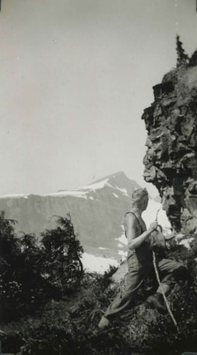
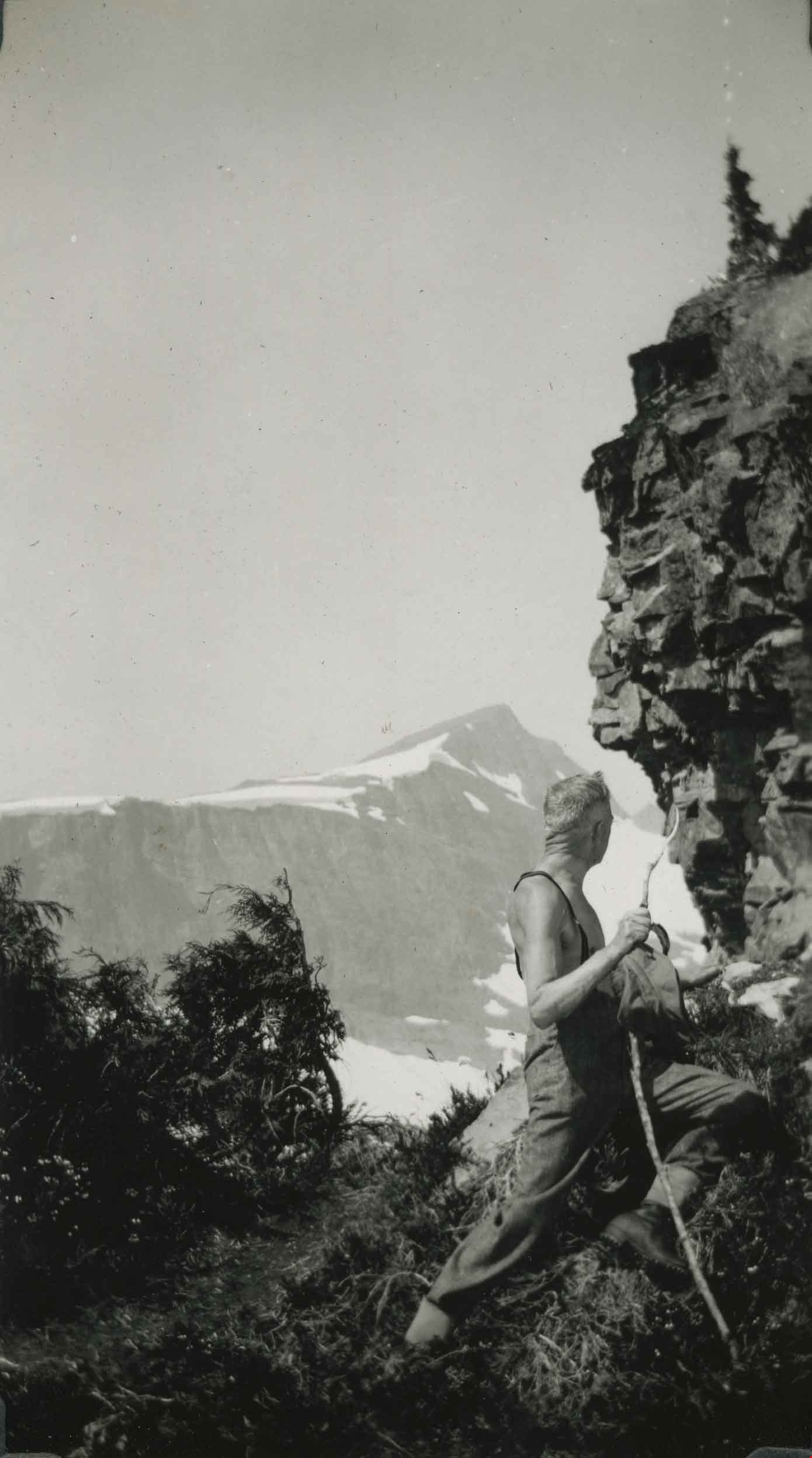
Mount Albert Edward 6871 feet
https://search.heritageburnaby.ca/link/archivedescription51455
- Repository
- City of Burnaby Archives
- Date
- July 21, 1938
- Collection/Fonds
- Burnaby Historical Society fonds
- Description Level
- Item
- Physical Description
- 1 photograph : b&w ; 13 x 8 cm, mounted on heavy-weight paper 17.5 x 26.5 cm
- Scope and Content
- Photograph of a hiker leaning against the rock face on Mount Albert Edward and looking at the faces that have been carved into it. Another mountain is visible in the distance. This was part of a trip to the Forbidden Plateau on Vancouver Island made by a small party of City of Courtenay officials. …
- Repository
- City of Burnaby Archives
- Date
- July 21, 1938
- Collection/Fonds
- Burnaby Historical Society fonds
- Subseries
- George Grant subseries
- Physical Description
- 1 photograph : b&w ; 13 x 8 cm, mounted on heavy-weight paper 17.5 x 26.5 cm
- Description Level
- Item
- Record No.
- 243-060
- Access Restriction
- No restrictions
- Reproduction Restriction
- No known restrictions
- Accession Number
- BHS1990-06
- Scope and Content
- Photograph of a hiker leaning against the rock face on Mount Albert Edward and looking at the faces that have been carved into it. Another mountain is visible in the distance. This was part of a trip to the Forbidden Plateau on Vancouver Island made by a small party of City of Courtenay officials. George A. Grant was one of the climbers in the party.
- Media Type
- Photograph
- Notes
- Title taken from handwritten title on paper mount
- Handwritten note on paper mount reads: "How many Cowichan Indian faces on the lookout?"
- Second handwritten note on paper mount reads: "After about 5 hours 21st JULY 1938 'Yes it looks quite a step yet, but we'll make it in a couple of hours or so."
Images
![Pages from May Aikenhead scrapbook, [1930-1935] thumbnail](/media/hpo/_Data/_BVM_Images/2015/2015_0035_0168_all_pages.jpg?width=280)
Pages from May Aikenhead scrapbook
https://search.heritageburnaby.ca/link/museumdescription5245
- Repository
- Burnaby Village Museum
- Date
- [1930-1935]
- Collection/Fonds
- Burnaby Girl Guides fonds
- Description Level
- File
- Physical Description
- 1 file of textual records : 1 p. + 1 illustration : col. ; graphite and watercolour + 1 digital file : col. (pdf) + 10 photographs : col. (tiffs)
- Scope and Content
- File consists of pages from a scrapbook created by May Aitkenhead. Pages include an illustration of a Girl Guide in uniform done in pencil and watercolour along with two pages (double sided) of clippings from newspapers, magazines and a programme. The illustration page includes the name "Mabel McIn…
- Repository
- Burnaby Village Museum
- Collection/Fonds
- Burnaby Girl Guides fonds
- Description Level
- File
- Physical Description
- 1 file of textual records : 1 p. + 1 illustration : col. ; graphite and watercolour + 1 digital file : col. (pdf) + 10 photographs : col. (tiffs)
- Scope and Content
- File consists of pages from a scrapbook created by May Aitkenhead. Pages include an illustration of a Girl Guide in uniform done in pencil and watercolour along with two pages (double sided) of clippings from newspapers, magazines and a programme. The illustration page includes the name "Mabel McIntyre / Cl. 16" handwritten in pencil at the top of the page along with a sticker of a wreath. The newspaper clippings page is titled "Guide News" and includes selected clippings about the 5th Burnaby Girl Guides, while two other pages include information titled "Patrol Portfolio Chart No. 9 _ Digging"; "The Aims of the Girl Guides" and "Girl Guiding" with photographic images of Mrs. Alan Morkill (Provincial Commissioner for British Columbia); Countess Bessborough (Honourary President of the Canadian Girl Guide Association); His Excellency Rt. Hon. the Earl of Bessborough (Governor General and Commander in Chief of the Dominion of Canada- Chief Scout of Canada) as well as Lady and Lord Baden Powell. The last page is clipped and pasted from a programme and/or poster "Grand Rally / Scouts / and / Guides / April 15th 1935 / Hastings Park / Vancouver BC" and includes a page of the programme.
- Creator
- Aitkenhead, May
- Names
- Girl Guides of Canada
- Accession Code
- BV015.35.168
- Access Restriction
- No restrictions
- Reproduction Restriction
- May be restricted by third party rights
- Date
- [1930-1935]
- Media Type
- Textual Record
- Graphic Material
- Notes
- Title based on contents of file
- Digital images were created of the scrapbook prior to selective retention of original records
- Selected pages were removed from original scrapbook and were retained under BV015.35.168
- Selected photographs were removed from scrapbook prior and are described at item level (BV015.35.292 to BV015.35.300)
Images
![Pages from May Aikenhead scrapbook, [1930-1935] thumbnail](/media/hpo/_Data/_BVM_Images/2015/2015_0035_0168_all_pages.jpg)
Documents
Personal material
https://search.heritageburnaby.ca/link/archivedescription82732
- Repository
- City of Burnaby Archives
- Date
- [1910-1978]
- Collection/Fonds
- Hazel Simnett collection
- Description Level
- File
- Physical Description
- 9 paintings : colour print, 2 photographs : b&w, and 1 folder of textual records
- Scope and Content
- File consists of application for a driver's license, Kingsway Driving School report card, driver's examination receipt and a letter addressed to Hazel Simnett from the Victorian Order of Nurses for Canada. Also included is an immigration inspection card of Fred Simnett aboard the S.S. Lake Champlai…
- Repository
- City of Burnaby Archives
- Date
- [1910-1978]
- Collection/Fonds
- Hazel Simnett collection
- Physical Description
- 9 paintings : colour print, 2 photographs : b&w, and 1 folder of textual records
- Description Level
- File
- Record No.
- MSS167-008
- Accession Number
- 2013-22
- Scope and Content
- File consists of application for a driver's license, Kingsway Driving School report card, driver's examination receipt and a letter addressed to Hazel Simnett from the Victorian Order of Nurses for Canada. Also included is an immigration inspection card of Fred Simnett aboard the S.S. Lake Champlain from Liverpool and a letter from the Office of the Mayor addressed to Mary Ann Simnett for her ninetieth birthday. Also included is a photograph (see item 559-001). Also included are newsclippings regarding Robert Burnaby and the "Bygones of Burnaby" book, a programme of the Robert Burnaby Commemorative Dinner, a photocopy of "The Argus" (Burnaby South High School's newspaper) from 1938, a programme from Madys Pridmore Brown's Variety Programme, "The Buzzer" Volume 40 Issue 16 advertising Vancouver street cars, New Vista Society certificate addressed to Hazel Simnett, an envelope of Fenwick Lansdowne bird prints from 1957 and a print of the Royal Family found in a cardboard envelope postmarked 1972.
- Subjects
- Arts - Paintings
- Documentary Artifacts - Newspapers
- Documentary Artifacts - Photographs
- Performances - Concerts
- Organizations - Societies and Clubs
- Personal Symbols - Certificates
- Transportation
- Persons - Royalty
- Media Type
- Textual Record
- Photograph
- Graphic Material
- Notes
- Title based on note accompanying file on folder ; The Argue was stapled together
- Simnett personal papers series
- Historic Neighbourhood
- Alta-Vista (Historic Neighbourhood)
- Planning Study Area
- Clinton-Glenwood Area
Interview with Annie Boulanger by Rod Fowler April 9, 1990 - Track 6
https://search.heritageburnaby.ca/link/oralhistory488
- Repository
- City of Burnaby Archives
- Date Range
- 1925-1970
- Length
- 00:07:42
- Summary
- This portion of the interview is about Annie Boulanger’s family history, her parents’ origin, work and move to Burnaby, what the Napier Street area looked like in the 1950s and the Government Street neighbourhood in the 1960s, her education and teaching career, and her marriage. She explains why Go…
- Repository
- City of Burnaby Archives
- Summary
- This portion of the interview is about Annie Boulanger’s family history, her parents’ origin, work and move to Burnaby, what the Napier Street area looked like in the 1950s and the Government Street neighbourhood in the 1960s, her education and teaching career, and her marriage. She explains why Government Street has a jog in it at Brighton.
- Date Range
- 1925-1970
- Length
- 00:07:42
- Subjects
- Occupations - Teachers
- Historic Neighbourhood
- Vancouver Heights (Historic Neighbourhood)
- Lozells (Historic Neighbourhood)
- Planning Study Area
- Burnaby Heights Area
- Government Road Area
- Interviewer
- Fowler, Rod
- Interview Date
- April 9, 1990
- Scope and Content
- Recording is of an interview with Annie Boulanger, conducted by Rod Fowler. Annie Boulanger was one of eleven participants interviewed as part of the SFU/Burnaby Centennial Committee's oral history series titled, "Voices of Burnaby". The interview is mainly about Annie Boulanger’s volunteer community work in Burnaby, including initiating the teaching of french and gymnastics at Seaforth School where her children attended, doing historical research and oral histories for Burnaby Heritage Village and the SFU Archives, becoming a long term member of the Burnaby Writers’ Club, being a member and President of Burnaby Arts Council, and member of the Parks Board's Centre for the Performing Arts Committee (1987). The interview focuses attention on the Arts Council’s financial difficulties between 1985 and 1990, and the need for a comprehensive approach to supporting the arts through a municipal arts policy. Annie Boulanger also talks about her parents’ history, their home on Napier Street and her later home on Government Road, her education and teaching career, and her arts journalism. To view “Narrow By” terms for each track expand this description and see “Notes”.
- Biographical Notes
- Annie Urbanovits Boulanger’s parents emigrated from Hungary to Toronto, Louis in 1925 and Irene in 1930, where they married. Louis and Irene Boulanger moved to Vancouver where Louis worked in the Vancouver Shipyards during WWII and then for Nichols Chemical Company in Barnet for 15 years. While the Urbanovits family lived in Cloverdale, Louis commuted to Kask’s Camp in Barnet, until they moved to Burnaby in 1951 to an old farm purchased on Napier Street. Between 1951 and 1956 Annie completed her BA degree, majoring in chemistry and english with a minor in physical education, and obtained her teaching diploma at UBC. She taught for 4 years in various locations in BC before marrying and moving to Manitoba and Ottawa. She and her husband and five children (two more children to come later) returned to Burnaby in 1964 to a home on Government Street to be close to family. Annie Boulanger became involved in the community first through her children’s school, initiating and teaching french classes in Seaforth School in 1969, and supporting the development of gymnastics in school and as a municipal program. Her interest in Archives lead to doing oral histories for John Adams, curator of Heritage Village [Burnaby Heritage Village], and for SFU Archives. She became a long time member of the Burnaby Writers’ Club in the 1970s, taking a course in writing non-fiction from Chris Potter. In 1983 Annie Boulanger joined the Burnaby Arts Council, becoming President in 1985. She was involved in lobbying the municipality for better monetary support and facilities for the arts and for the creation of a Municipal Arts Policy. She has continued to promote the arts in Burnaby through her appointment to Burnaby’s Visual Arts Advisory Board in 1997, her arts journalism, writing regular book and theatre reviews for the local newspaper, and other activities. She was a member of the Burnaby Centennial Committee and was one of the editors of the book “Burnaby Centennial Anthology”.
- Total Tracks
- 8
- Total Length
- 0:41:53
- Interviewee Name
- Boulanger, Annie
- Interviewer Bio
- Rod Fowler returned to university as a mature student in the 1980s after working about twenty years in the field of economics and computerization in business in England, Europe and Western Canada. He graduated with a BA from SFU in both History and Sociology in 1987, his MA degree in Geography in 1989, and his PhD in Cultural Geography at SFU. He taught courses in Geography, Sociology, History and Canadian Studies at several Lower Mainland colleges, before becoming a full time member of the Geography Department at Kwantlen University College.
- Collection/Fonds
- SFU/Burnaby Centennial Committee fonds
- Transcript Available
- Transcript available
- Media Type
- Sound Recording
- Web Notes
- Interviews were digitized in 2015 allowing them to be accessible on Heritage Burnaby. The digitization project was initiated by the Community Heritage Commission with support from City of Burnaby Council.
Audio Tracks
Track six of interview with Annie Boulanger
Track six of interview with Annie Boulanger
https://search.heritageburnaby.ca/media/hpo/_Data/_Archives_Oral_Histories/_Unrestricted/MSS187-022/MSS187-022_Track_6.mp3