More like 'Simon Fraser University'
Narrow Results By
Decade
- 2020s
- 2010s 118
- 2000s 663
- 1990s 649
- 1980s 487
- 1970s 985
- 1960s 405
- 1950s 552
- 1940s 599
- 1930s 611
- 1920s 655
- 1910s 606
- 1900s
- 1890s 36
- 1880s 72
- 1870s 5
- 1860s 3
- 1850s 1
- 1840s 1
- 1830s 1
- 1820s 1
- 1810s 1
- 1800s 1
- 1790s 1
- 1780s 1
- 1770s 1
- 1760s 1
- 1750s 1
- 1740s 1
- 1730s 1
- 1720s 1
- 1710s 1
- 1700s 1
- 1690s
- 1680s 1
- 1670s 1
- 1660s 1
- 1650s 1
- 1640s 1
- 1630s 1
- 1620s 1
- 1610s 1
- 1600s 1

Duncan & Margaret McGregor Estate 'Glen-Lyon' Mansion
https://search.heritageburnaby.ca/link/landmark518
- Repository
- Burnaby Heritage Planning
- Description
- Overlooking the rich farmland of the Fraser River floodplain, 'Glen-Lyon' is an Edwardian era rural estate, with a tall, two and one-half storey plus basement wood-frame mansion, set in a pastoral and formal landscape with an associated barn and early log pond, located near a ravine and forested ar…
- Associated Dates
- 1902
- Formal Recognition
- Heritage Designation, Community Heritage Register
- Street View URL
- Google Maps Street View
- Repository
- Burnaby Heritage Planning
- Geographic Access
- Marine Drive
- Associated Dates
- 1902
- Formal Recognition
- Heritage Designation, Community Heritage Register
- Enactment Type
- Bylaw No. 12183
- Enactment Date
- 11/12/2006
- Description
- Overlooking the rich farmland of the Fraser River floodplain, 'Glen-Lyon' is an Edwardian era rural estate, with a tall, two and one-half storey plus basement wood-frame mansion, set in a pastoral and formal landscape with an associated barn and early log pond, located near a ravine and forested area adjacent to Marine Drive in South Burnaby.
- Heritage Value
- ‘Glen-Lyon’ is valued as an excellent example of a privately-owned Edwardian era country estate built at the turn of the nineteenth century. The property retains significant heritage features including the Edwardian era mansion with rustic Arts and Crafts features, and elements of a working agricultural landscape. The property was originally the Royal City Mills logging camp, and in 1900 was purchased by Duncan Campbell McGregor (1853-1929) and Margaret Jane McGregor (1875-1960), who named their estate ‘Glen-Lyon’ after Duncan McGregor’s birthplace in Perthshire, Scotland. The McGregors were active in municipal affairs and social activities, and played a significant role in the early development of Burnaby. Duncan McGregor served as a city councillor from 1909 to 1912 and was elected reeve of Burnaby in 1913. Margaret McGregor was instrumental in the formation and fundraising activities of the Victoria Order of Nurses in Burnaby. Additionally, the site is historically significant for its association with early social welfare and correctional reform. The estate was sold in 1926 to an inter-denominational religious organization called the Home of the Friendless, which used it as their B.C. headquarters. The organization was charged with several cases of abuse and neglect in 1937, after which a Royal Commission was formed that led to new legislation to regulate and license all private welfare institutions. 'Glen-Lyon' was sold to the provincial government, and was dedicated in 1939 by the Lt.-Gov. E.W. Hamber for use as the New Haven Borstal Home for Boys and Youthful Offenders (later renamed the New Haven Correction Centre). The Borstal movement originated in England in the late nineteenth century, as an alternative to sending young offenders and runaways to prisons by providing reformatories that focused on discipline and vocational skill. This site’s role as the first North American institution devoted to the Borstal School philosophy was historic, and influenced corrections programs across Canada. The site retains significant features from its development in 1939 as the Borstal School, including a large gambrel-roofed barn designed by Chief Provincial Architect Henry Whittaker of the Department of Public Works that is the only remaining structure of its kind in Burnaby. Between 1941 and 1945 the mansion housed the Provincial School for the Deaf and Blind when the Borstal School was closed temporarily as a war measure during the Second World War.
- Defining Elements
- Key elements that define the heritage character of 'Glen-Lyon' Mansion include its: - location on a sloping site with expansive southern exposure, adjacent to Marine Drive - residential form, scale and massing of the house as exemplified by its two and one-half storey height, above-ground basement and rectangular plan - Arts and Crafts elements of the house such as its stone foundation, multi-gabled roof line with steep central hipped roof, symmetrical cross-gables, side shed dormers, bellcast upper walls sheathed in cedar shingles and lower walls sheathed in narrow clapboard - original exterior features of the house such as the full width front verandah with square columns, central staircase on the southern elevation, original doors and stained glass windows; and the irregular fenestration such as double-hung 1-over-1 wooden-sash windows, bay windows, and projecting windows in the gable ends - original interior features of the house such as the U-shaped main stair designed around two symmetrically placed Ionic columns, and interior trim on the main floor including boxed beams and fireplaces - gambrel-roofed barn with roof vent with finial, sliding hay loft and access doors, small multi-pane windows, and lapped wooden siding - associated landscape features such as the original garden plantings with some exotic and many native specimen trees; the original log pond and its concrete Marine Drive causeway and culvert; rockeries and a rose garden
- Historic Neighbourhood
- Fraser Arm (Historic Neighbourhood)
- Planning Study Area
- Big Bend Area
- Architect
- Henry Whittaker
- Function
- Primary Historic--Estate
- Community
- Burnaby
- Cadastral Identifier
- 003-004-661
- Boundaries
- 'Glen-Lyon' is comprised of a single residential lot located at 4250 Marine Drive, Burnaby.
- Area
- 230873.18
- Contributing Resource
- Building
- Ownership
- Private
- Names
- McGregor, Duncan C. (1853-1929)
- Whittaker, Henry
- Home of the Friendless
- Borstal School
- New Haven Correction Centre
- Subjects
- Buildings - Heritage
- Buildings - Residential - Houses
- Buildings - Public - Detention Facilities
- Buildings - Residential
- Street Address
- 4250 Marine Drive
- Street View URL
- Google Maps Street View
Images


H.T. Ceperley Estate 'Fairacres' Steam Plant Building
https://search.heritageburnaby.ca/link/landmark528
- Repository
- Burnaby Heritage Planning
- Description
- Designed in the British Arts and Crafts style, the ‘Fairacres’ Steam Plant Buiding is a single-storey wood frame building with a gabled roof that originally housed the apparatus for climate control in the greenhouses, formerly located to its north. The original rubble stone walls that formed the fo…
- Associated Dates
- 1908
- Formal Recognition
- Heritage Designation, Community Heritage Register
- Repository
- Burnaby Heritage Planning
- Geographic Access
- Deer Lake Avenue
- Associated Dates
- 1908
- Formal Recognition
- Heritage Designation, Community Heritage Register
- Enactment Type
- Bylaw No. 9807
- Enactment Date
- 23/11/1992
- Description
- Designed in the British Arts and Crafts style, the ‘Fairacres’ Steam Plant Buiding is a single-storey wood frame building with a gabled roof that originally housed the apparatus for climate control in the greenhouses, formerly located to its north. The original rubble stone walls that formed the foundation for the greenhouses stand adjacent. The Steam Plant Building stands as a pendant to the Root House, which is to the north of the former greenhouses.
- Heritage Value
- The outbuildings at 'Fairacres' are a rare surviving architecturally-designed ensemble of agricultural structures that exist in complementary harmony with the main estate house. Architect Robert Mackay Fripp (1858-1917), an outspoken advocate of Arts and Crafts design, was retained by the Ceperleys to design several original outbuildings on their estate. The Ceperleys operated 'Fairacres' with staff, a farm manager and workers, including Chinese, to grow produce for themselves and for sale at local markets. The Steam Plant Building illustrates the market gardening activity of the area around Deer Lake and its importance to the Ceperley family, which valued a year-round supply of fresh fruit and vegetables for the kitchen and flowers for the house. It also illustrates the cultural and aesthetic values of the Ceperleys in retaining an architect to design a functional outbuilding using an accepted and contemporary architectural style. Built in 1908, the Steam Plant Building was significantly altered in the 1960s and restored to its original design in 2000.
- Defining Elements
- Key elements that define the heritage character of the ‘Fairacres’ Steam Plant Building include its: - overall spatial arrangement of the Steam Plant Building in relation to the former greenhouses and the Root House - side gable roof with cedar shingle cladding. - tall brick chimney indicitive of the building's original function. - distinctive Arts and Crafts architectural features such as the shingle wall cladding with decorative shingling under window sills, deep eaves, and pebble-dashed concrete foundation walls - six-paned wooden-sash casement windows - simple functional interior features - rubble stone walls that formed the foundation for the greenhouses
- Locality
- Deer Lake Park
- Historic Neighbourhood
- Burnaby Lake (Historic Neighbourhood)
- Planning Study Area
- Douglas-Gilpin Area
- Architect
- Robert Mackay Fripp
- Function
- Primary Historic--Outbuilding
- Community
- Burnaby
- Cadastral Identifier
- P.I.D. No. 004-493-311 Legal Description: Block 3 Except: Part subdivided by Plan 26865, District Lot 79, Group 1, New Westminster District, Plan 536
- Boundaries
- ‘Fairacres’ is comprised of a single municipally-owned property located at 6344 Deer Lake Avenue, Burnaby.
- Area
- 17,065.00
- Contributing Resource
- Building
- Landscape Feature
- Ownership
- Public (local)
- Other Collection
- Burnaby Historical Society, Community Archives: Ceperley Photograph Album
- Documentation
- Heritage Site Files: PC77000 20. City of Burnaby Planning and Building Department, 4949 Canada Way, Burnaby, B.C., V5G 1M2
- Street Address
- 6344 Deer Lake Avenue
Images


H.T. Ceperley Estate 'Fairacres' Greenhouse Foundation Wall
https://search.heritageburnaby.ca/link/landmark862
- Repository
- Burnaby Heritage Planning
- Description
- The original rubble stone walls that formed the foundation for a greenhouses adjacent to the Steam Plant Building provided heat to several greenhouses on the estate propoerty. The Root House, which is to the north of the Greenhouse Foundation Wall, provided storage for the farm operation.
- Associated Dates
- 1908
- Formal Recognition
- Heritage Designation, Community Heritage Register
- Repository
- Burnaby Heritage Planning
- Geographic Access
- Deer Lake Avenue
- Associated Dates
- 1908
- Formal Recognition
- Heritage Designation, Community Heritage Register
- Enactment Type
- Bylaw No. 140665
- Enactment Date
- 23/11/1992
- Description
- The original rubble stone walls that formed the foundation for a greenhouses adjacent to the Steam Plant Building provided heat to several greenhouses on the estate propoerty. The Root House, which is to the north of the Greenhouse Foundation Wall, provided storage for the farm operation.
- Heritage Value
- The outbuildings at 'Fairacres' are a rare surviving architecturally-designed ensemble of agricultural structures that exist in complementary harmony with the main estate house. Architect Robert Mackay Fripp (1858-1917), an outspoken advocate of Arts and Crafts design, was retained by the Ceperleys to design several original outbuildings on their estate, which was designed as a country estate with a working farm that included over 10 acres of productive berry and vegetable fields, with a large kitchen garden, a root house to store food, an orchard, and greenhouses heated by steam. The agricultural potential of the Deer Lake area made it one of the first parts of the municipality to attract settlement. In 1909, the Ceperleys built three large greenhouses heated by an adjacent steam plant (Fairacres Steam Plant). The greenhouses featured granite foundation walls, including this one which remains intact. The Ceperleys employed a large staff to manage the estate's agricultural production, including Chinese farm labourers. Produce was grown for use at the estate, and for sale at local markets. Agricultural use of the estate continued when a Catholic order of Benedictine monks purchased the estate as part of the Priory of St. Joseph and the Seminary of Christ the King, and continued to farm the land until 1953.
- Defining Elements
- Key elements that define the heritage character of the ‘Fairacres’ Steam Plant Building include its: - overall spatial arrangement of the Greenhouse Foundation Wall in relation to the Steam Plant Building and the Root House - original rubble stone walls reflecting the Arts and Crafts design aesthetic of the estate buildings.
- Locality
- Deer Lake Park
- Historic Neighbourhood
- Burnaby Lake (Historic Neighbourhood)
- Planning Study Area
- Douglas-Gilpin Area
- Architect
- Robert Mackay Fripp
- Function
- Primary Historic--Outbuilding
- Community
- Burnaby
- Cadastral Identifier
- P.I.D. No. 004-493-311 Legal Description: Block 3 Except: Part subdivided by Plan 26865, District Lot 79, Group 1, New Westminster District, Plan 536
- Boundaries
- ‘Fairacres’ is comprised of a single municipally-owned property located at 6344 Deer Lake Avenue, Burnaby.
- Area
- 17,065.00
- Contributing Resource
- Landscape Feature
- Remains
- Ownership
- Public (local)
- Other Collection
- Burnaby Historical Society, Community Archives: Ceperley Photograph Album
- Documentation
- Heritage Site Files: PC77000 20. City of Burnaby Planning and Building Department, 4949 Canada Way, Burnaby, B.C., V5G 1M2
- Street Address
- 6344 Deer Lake Avenue
Images


H.T. Ceperley Estate 'Fairacres' Root House
https://search.heritageburnaby.ca/link/landmark527
- Repository
- Burnaby Heritage Planning
- Description
- The ‘Fairacres’ Root House is a long, low one-storey masonry building, measuring 4.6 metres by 9.1 metres, with massively buttressed concrete walls and foundations. Built into sloping ground adjacent to the location of the former greenhouses, the surviving orchard and the kitchen entrance of the ma…
- Associated Dates
- 1908
- Formal Recognition
- Heritage Designation, Community Heritage Register
- Repository
- Burnaby Heritage Planning
- Geographic Access
- Deer Lake Avenue
- Associated Dates
- 1908
- Formal Recognition
- Heritage Designation, Community Heritage Register
- Enactment Type
- Bylaw No. 9807
- Enactment Date
- 23/11/1992
- Description
- The ‘Fairacres’ Root House is a long, low one-storey masonry building, measuring 4.6 metres by 9.1 metres, with massively buttressed concrete walls and foundations. Built into sloping ground adjacent to the location of the former greenhouses, the surviving orchard and the kitchen entrance of the main house, 'Fairacres,' this functional structure was used as a frost-free store for fruit and vegetables for the family's use.
- Heritage Value
- The outbuildings at 'Fairacres' are a rare surviving architecturally-designed ensemble of agricultural structures that exist in complementary harmony with the main estate house. Architect Robert Mackay Fripp (1858-1917), an outspoken advocate of Arts and Crafts design, was retained by the Ceperleys to design several original outbuildings on their estate. The Root House is important as a rare surviving, and exceptionally large, example of this building type in the Vancouver region. Unusual in the fact that an architect designed a building of such modest aspirations, it is also remarkable in its method of construction. The use of concrete as a structural material is one of the earliest in the region and extraordinary for its use on such a modest vernacular outbuilding; root cellars were typically built of loose stone. Built in 1908, the Root House was significantly altered in the 1960s and restored to its original design in 2000. The building is significant as an indicator of the market gardening activity in the area around Deer Lake and of the country-house self-sufficiency practiced by the Ceperley family. The Root House illustrates the cultural, aesthetic, and lifestyle values of the Ceperleys in constructing such a large building for storing their own produce.
- Defining Elements
- The outbuildings at 'Fairacres' are a rare surviving architecturally-designed ensemble of agricultural structures that exist in complementary harmony with the main estate house. Architect Robert Mackay Fripp (1858-1917), an outspoken advocate of Arts and Crafts design, was retained by the Ceperleys to design several original outbuildings on their estate. The Root House is important as a rare surviving, and exceptionally large, example of this building type in the Vancouver region. Unusual in the fact that an architect designed a building of such modest aspirations, it is also remarkable in its method of construction. The use of concrete as a structural material is one of the earliest in the region and extraordinary for its use on such a modest vernacular outbuilding; root cellars were typically built of loose stone. Built in 1908, the Root House was significantly altered in the 1960s and restored to its original design in 2000. The building is significant as an indicator of the market gardening activity in the area around Deer Lake and of the country-house self-sufficiency practiced by the Ceperley family. The Root House illustrates the cultural, aesthetic, and lifestyle values of the Ceperleys in constructing such a large building for storing their own produce.
- Locality
- Deer Lake Park
- Historic Neighbourhood
- Burnaby Lake (Historic Neighbourhood)
- Planning Study Area
- Douglas-Gilpin Area
- Architect
- Robert Mackay Fripp
- Function
- Primary Historic--Outbuilding
- Secondary Historic--Food Storage
- Community
- Burnaby
- Cadastral Identifier
- P.I.D. No. 004-493-311 Legal Description: Block 3 Except: Part subdivided by Plan 26865, District Lot 79, Group 1, New Westminster District, Plan 536
- Boundaries
- ‘Fairacres’ is comprised of a single municipally-owned property located at 6344 Deer Lake Avenue, Burnaby.
- Area
- 17,065.00
- Contributing Resource
- Building
- Landscape Feature
- Ownership
- Public (local)
- Other Collection
- Burnaby Historical Society, Community Archives: Ceperley Photograph Album
- Documentation
- Heritage Site Files: PC77000 20. City of Burnaby Planning and Building Department, 4949 Canada Way, Burnaby, B.C., V5G 1M2
- Street Address
- 6344 Deer Lake Avenue
Images

![Mountainside plank road, [190-] thumbnail](/media/hpo/_Data/_BVM_Images/1977/197900500189.jpg?width=280)
Mountainside plank road
https://search.heritageburnaby.ca/link/museumdescription446
- Repository
- Burnaby Village Museum
- Date
- [190-]
- Collection/Fonds
- Hugh H. Stewart fonds
- Description Level
- Item
- Physical Description
- 1 photograph : sepia ; 15.3 x 11.0 cm mounted on cardboard 24.5 x 17.8 cm
- Scope and Content
- Photograph of an automobile parked on the side of a plank road by a mountain rising steeply to the right of the image. An unidentified man is seen leaning on the fence at the side of the plank road.
- Repository
- Burnaby Village Museum
- Collection/Fonds
- Hugh H. Stewart fonds
- Description Level
- Item
- Physical Description
- 1 photograph : sepia ; 15.3 x 11.0 cm mounted on cardboard 24.5 x 17.8 cm
- Scope and Content
- Photograph of an automobile parked on the side of a plank road by a mountain rising steeply to the right of the image. An unidentified man is seen leaning on the fence at the side of the plank road.
- Accession Code
- HV979.50.189
- Access Restriction
- No restrictions
- Reproduction Restriction
- No known restrictions
- Date
- [190-]
- Media Type
- Photograph
- Scan Resolution
- 600
- Scan Date
- 2023-09-12
- Notes
- Title based on contents of photograph
Images
![Mountainside plank road, [190-] thumbnail](/media/hpo/_Data/_BVM_Images/1977/197900500189.jpg)
Oral history interview with Hipman "Jimmy" Chow and Donna Polos
https://search.heritageburnaby.ca/link/museumdescription19146
- Repository
- Burnaby Village Museum
- Date
- 29 Jun. 2022
- Collection/Fonds
- Hipman "Jimmy" Chow and Donna Polos fonds
- Description Level
- Item
- Physical Description
- 3 sound recordings (wav) (02:06:53 min) + 1 sound recording (mp3) (02:06:53 min)
- Scope and Content
- Item consists of an audio recording of an oral history interview with Jimmy Chow and Donna Polos conducted by Denise Fong with assistance from Burnaby Village Museum Assistant Curator, Kate Petrusa. During the interview, Jimmy Chow and Donna Polos discuss; their ancestral background, childhood, pla…
- Repository
- Burnaby Village Museum
- Collection/Fonds
- Hipman "Jimmy" Chow and Donna Polos fonds
- Description Level
- Item
- Physical Description
- 3 sound recordings (wav) (02:06:53 min) + 1 sound recording (mp3) (02:06:53 min)
- Material Details
- Interviewer: Denise Fong Co Interviewer and technical support: Kate Petrusa Interviewees: Hipman "Jimmy" Chow and Donna Polos Location of Interview: Home of Jimmy Chow and Donna Polos on Victory Street, Burnaby Date of interview: June 29, 2022 Total Number of Tracks: 3 Total length of all Tracks: 02:06:53 min Digital master recordings (wav) were recorded onto 3 separate audio tracks, edited and merged together and converted to mp3 for access on Heritage Burnaby
- Scope and Content
- Item consists of an audio recording of an oral history interview with Jimmy Chow and Donna Polos conducted by Denise Fong with assistance from Burnaby Village Museum Assistant Curator, Kate Petrusa. During the interview, Jimmy Chow and Donna Polos discuss; their ancestral background, childhood, places of residence, education, career history, how they met, Jimmy's experience working in the film industry, their home in Burnaby and their neighbourhood, their political activism in Burnaby, Robin Chung Dip's work in Vancouver’s' Chinatown, the gambling scene in Vancouver prior to legalized forms of gambling and their memories of supper clubs in Vancouver. 00:00 - 5:57 Opening introductions where Jimmy Chow and Donna Polos provide information on their full names, their birth places and their ancestral background. Jimmy clarifies that his birth name is Hipman Chow but that he was given the English name “Jimmy” by his father when he came to Canada. Jimmy shares that he was born in 1948, in the Village of Lin Pong Lee, Hoiping, China and immigrated to British Columbia with his mother, Gim Gee Chow in 1950 to escape the Communist Regime and to join his father who had already immigrated to Canada. Jimmy imparts that many Chinese immigrated to British Columbia in search of a better life, referring to it as “Gold Mountain” and that even though they faced extreme racial discrimination that many stayed since they felt that it was better than returning. Donna Polos shares ancestral information on both her maternal and paternal sides of the family. Donna’s mother’s family came from Helsinki, Finland. Donna’s paternal grandmother emigrated from Ukraine to Argentina and then to Winnipeg. Donna’s paternal grandfather, James Kostopolus (renamed Polos) emigrated as a 12 year old orphan from Sparta, Greece to the United States but was denied entry so ended up going to Halifax and eventually made his way to Vancouver. Once in Vancouver, he became a restaurant proprietor and over the years, he owned and operated three restaurants in Vancouver, including; “Jimmy’s Café” (next door the Astoria Hotel); “Home Apple Pie Café” (Princess Avenue & Hastings Street) and a restaurant that was located on Alma Street. 05:58 - 13:28 Jimmy recollects in further detail, the many places that his family lived over the years. Jimmy’s father Robin Chung Dip Chow immigrated to Vancouver at the age of 14 years and worked and lived in Victoria and Vancouver. In 1950, Jimmy and his mother fled China, first to Hong Kong and then to Vancouver to join his father. Soon after arriving in Vancouver, for the next four years, he and his parents lived in Manitoba, Saskatchewan and Quebec City where his father, Robin had work in restaurants and hotels. Jimmy attended school while the family lived in these different places and began to learn English. After four years, the family returned to Vancouver, first living in areas of Chinatown and Strathcona before settling in the neighbourhood of Mount Pleasant. Jimmy shares his memories of growing up in Strathcona and the Mount Pleasant neighbourhood, schools that he attended and the friendships that he made. Jimmy recollects details about the old Bethlehem Lutheran Church that he attended and describes the demands of the education required to become a Lutheran minister. 13:29 - 15:47 Jimmy tells of how his father, Robin Chung Dip Chow had to pay the Chinese Head Tax of $500 when he arrived in Vancouver at 14 years of age (1921) and how his father had to work hard pay off the head tax over the years. Denise Fong and Jimmy Chow, talk about the origin of a photograph portrait of Jimmy Chow that was taken around 1954 and speculate whether it might have been taken by well known portrait photographer, Yucho Chow. 15:48 - 19:33 Donna Polos recollects the many locations that her family lived while she was growing up in Vancouver. First residing at various locations in the downtown east side of Vancouver before moving to a home near Joyce Station where she lived until 21 years old. After 21 years of age, Donna moved in with roommates in Vancouver before moving in with Jimmy in North Burnaby in 1972. In 1976 Donna and Jimmy purchased their home on Victory Street. Both Donna and Jimmy talk about their careers after high school. Jimmy talks about how he worked at the Supervalu grocery store near his house. Jimmy planned to use his savings from his job to travel but instead he used his savings for a down payment on a house with Donna. Donna imparts that after obtaining her teaching degree she began working in Burnaby schools, eventually teaching at Burnaby South. 19:34 - 32:08 Both Jimmy and Donna share their educational background and experiences growing up. Jimmy first attended Florence Nightingale elementary in Strathcona, then Mount Pleasant Elementary and later high school at 24th Avenue and Main Street. Donna lists the schools that she attended including; elementary school in Strathcona, Carlton Elementary School at Kingsway and Joyce, Windermere High School, Vancouver City College (Langara) and the University of British Columbia. Donna and Jimmy reflect on public transportation that was available during the time they were growing up. Donna recollects her childhood growing up in the neighbourhood of Joyce Station, the freedom that she experienced playing outside in nature and what inspired her to become a teacher. Jimmy reflects on some of his mentors and about his first experience seeing movies as a young child at a cinema in Asquith, Saskatchewan. Donna communicates her own experiences of sexism throughout her high school, college and university education (1968-1972). 32:09 - 36:18 Donna talks about her career history and some of her major turning points. Donna recollects starting out as a Chemistry lab assistant, marking math papers before working as a teacher on call and eventually being hired as a teacher at Clinton Elementary School where she taught for nine years. Donna shares a memory of her first experience working as a teacher on call at Gilmore Elementary School and the fire that occurred there. After starting a family (Jimmy and Donna had three children) Donna worked part time teaching while Jimmy worked full time in film. Donna, shares that in 1991, after a near death experience, she became interested in fine art and took drawing and watercolour painting classes. With this experience, Donna experimented with different painting techniques on paper and fabric. Donna tells of how she retired from teaching in 2008 but continued to participate in the schools as an Artist in Residence. 36:19 - 58:18 Jimmy talks about his work and career history. He shares memories of his experiences as a young boy delivering newspapers, working at a local pharmacy, stocking shelves at the local supermarket, and his experience working with troubled youth and of how he thought that he might like to become a social worker. Jimmy tells of how he was uncertain of what to do until he got a job with the CBC in 1973 which eventually launched his career as a property master in the film industry, becoming a member of IATSE and a voting member of the Academy of Motion Pictures. Jimmy describes in detail what it means to be a property master and the work that is entailed in the film industry. 58:19 - 1:07:45 Donna Polos describes her art practice and her connection to Burnaby. Donna recollects how she first started working with textiles and fabrics from a young age and how this later inspired her to develop her own watercolour techniques of painting on paper, canvas and fabrics. Donna describes how she first got started by taking art classes in Burnaby and now has over 31 years of experience working in watercolour. Donna has worked as an Artist in Residence in Burnaby schools, been a member of the Burnaby Arts Council, had her first show in 1997 and has been involved in many art projects over the years. Donna describes the style of her work, first starting with more figurative work, social commentary and still life and that now most of her work is landscape based. Donna coveys that as a political activist in Burnaby, she was an active participant in the development of a tree bylaw, has petitioned to protect renters from demo-evictions and the impacts of future development on the local environment. 1:07:46 - 1:07:59 Background discussion between Denise Fong and Kate Petrusa re interviews. 1:08:00 - 1:26:36 Jimmy provides information on his connection to the local film industry and the changes that have occurred over the years. Jimmy describes the first studios on the North Shore and the eventual establishment of Bridge Studios on Boundary Road. Jimmy shares that in 1988, he and some of his colleagues in the film industry put a proposal together to buy the Bridge Studios but it didn't go through. Since the Bridge Studios and other film studios have been established in Burnaby and Vancouver, the industry has grown exponentially. Jimmy became the 54th member of the local IATSE union. Jimmy describes some of his experiences working on various productions including "Seven Years in Tibet", provides a description of what a film studio is, how it is used and the differences between working in the film industry in the United States and British Columbia. 1:26:37 - 1:32:46 Jimmy and Donna recollect how they first met, buying a house in Burnaby, getting married and starting a family. The two share memories of their wedding in White Rock and Jimmy talks about the Chinese hair cutting ceremony in recognition of their first born child that took place in Chinatown in Vancouver. Jimmy tells of how his parents had hopes of him marrying a Chinese woman and his mother began introducing him to a few young Chinese women from the time he was 16 years old. Jimmy mentions that his parents rarely used Western Medicine and relied on Traditional Chinese Medicine. Donna and Jimmy talk about Jimmy's parents, when they died and how happy his parents were to have grandchildren. 1:32:47 - 1:40:13 Jimmy and Donna talk about their house on Victory Street which they purchased in 1976. They share information on the history of the house, how it was built in 1939 by Norm Clark, how they fell in love with the design of the house and the neighbourhood. 1:40:14 - 1:58:31 Jimmy and Donna share information on their family life in Burnaby, their neighbourhood and favourite places in Burnaby. Donna lists the schools that their three children attended including; Nelson Avenue School, Burnaby South High School and Burnaby Central High School. Both Donna and Jimmy convey that all of their children played soccer and the benefits that the sport provided them. Donna and Jimmy talk about how the neighbourhood has changed over the years, the benefits of where they live, their fondness for built heritage and the many parks and trees in Burnaby. 1:58:32 - 2:02:50 Jimmy begins to share information on his father, Robin Chung Dip Chow's employment history. Jimmy recalls that his father, Robin worked in a variety of jobs over the years and as a young child, Jimmy was uncertain of what his father's job was but thought that he worked in accounting. He mentions that his father stopped working at 45 years of age due to a problem with his Achilles tendon. Jimmy describes his father as an intellectual who worked at gambling houses in Vancouver's Chinatown where people played mah-jong and fan-tan. Jimmy recollects that these were large clubs with lots of employees. His father never gambled but he was good with money so he worked on the management side. Jimmy mentions that while working in the film industry, his father took him and some of his film colleagues into some of the gambling houses in Chinatown to assist them with a production that they were working on. 2:02:51 - 2:06:58 Donna shares her own family history regarding gambling. She mentions that her uncle worked as a high end "bookie" in Vancouver and how in 1968, her uncle was arrested but got let go with just a small fine. Jimmy describes what gambling was like in those days with various sweepstakes, not under the jurisdiction of the government like it is today. Both Donna and Jimmy recollect the popularity of supper clubs their memories of Vie's Chicken and Steak House that was located in Hogan's Alley. Jimmy laments the destruction of Hogan's Alley and the other proposals that were brought forward that would change Chinatown and Strathcona.
- History
- Interviewees biography: Hipman "Jimmy" Chow was born in Lin Pong Lee, Hoiping, China in 1948. In 1950, Jimmy Chow immigrated to Vancouver from China with his mother, Gim Gee Chow to join his father, Robin Chung Dip Chow who'd immigrated to Canada at 14 years of age in 1921. For the first four years after immigrating, Jimmy and his parents lived in Manitoba, Saskatchewan and Quebec before returning to Vancouver around 1954. Jimmy and his family then lived and worked in Vancouver eventually settling in the neighbourhood of Mount Pleasant. In the early 1970s, Jimmy met his future wife Donna Polos and they married in 1981. Donna Polos was born in 1949 to Donald James Polos and Mayme "May" Helen Tilikana Polos and grew up in Vancouver. Between the age of 5 and 21 years, Donna lived in the neighbourhood of Joyce Station. In 1976, Jimmy and Donna purchased and moved into a house on Victory Street in Burnaby where they still live today. While living on Victory Street, they've raised their three children. Donna received her teaching degree and taught in elementary schools for many years. In 1991, after a near death experience, Donna developed an interest in drawing and painting and began experimenting with water colour painting on fabric. Donna has since exhibited her work widely, participated as an Artist in Residence in Burnaby schools and is a member of the Federation of Canadian Artists. Jimmy entered the film industry in 1973, gaining experience and recognition as a property master and has worked on many films over a 45 year career. Interviewer biography: Denise Fong is a historical researcher at Burnaby Village Museum. She has degrees in Anthropology (BA) and Archaeology (MA), and is completing her doctoral degree at UBC in Interdisciplinary Studies. Her primary research interests are in Chinese Canadian history and critical heritage studies. She is the co-curator of BVM’s “Across the Pacific” exhibition, and the Museum of Vancouver’s “A Seat at the Table – Chinese Immigration and British Columbia”.
- Creator
- Burnaby Village Museum
- Subjects
- Buildings - Commercial - Restaurants
- Buildings - Residential
- Buildings - Residential - Houses
- Education
- Geographic Features - Parks
- Geographic Features - Neighbourhoods
- Government - Local Government
- Industries - Film
- Migration
- Occupations
- Occupations - Artists
- Occupations - Grocers
- Occupations - Entrepreneurs
- Occupations - Teachers
- Persons - Chinese Canadians
- Social Issues - Racism
- Sports - Soccer
- Names
- Bridge Studios
- Chow, Gim Gee Dang
- Chow, Hipman "Jimmy"
- Chow, Robin Chung Dip
- Polos, Donna
- Polos, James "Jimmy", 1898-1962
- Polos, Donald James
- Polos, Mayme "May" Helen Tilikana
- Geographic Access
- Victory Street
- Accession Code
- BV022.21.1
- Date
- 29 Jun. 2022
- Media Type
- Sound Recording
- Notes
- Title based on contents of recording
- Hipman "Jimmy" Chow's name in Cantonese is Chow Hipman and in Mandarin is Zhou Xiamin.
Images
Audio Tracks
Oral history interview with Hipman
Oral history interview with Hipman
https://search.heritageburnaby.ca/media/hpo/_Data/_BVM_Sound_Recordings/Oral_Histories/2022_0021_0001_004.mp3
Trafalgar Market
https://search.heritageburnaby.ca/link/archivedescription98665
- Repository
- City of Burnaby Archives
- Date
- 2022
- Collection/Fonds
- Disappearing Burnaby collection
- Description Level
- Item
- Physical Description
- 1 photograph (jpeg) : col.
- Scope and Content
- Photograph of the intersection of Imperial Street and Sussex Avenue at night and in the rain. The photograph shows the Trafalgar Market grocery store (located at 4398 Imperial Street; the building was constructed in 1940) on the corner, with a large display of flowers for sale under the awning in f…
- Repository
- City of Burnaby Archives
- Date
- 2022
- Collection/Fonds
- Disappearing Burnaby collection
- Physical Description
- 1 photograph (jpeg) : col.
- Description Level
- Item
- Record No.
- 634-012
- Access Restriction
- No restrictions
- Reproduction Restriction
- No restrictions
- Accession Number
- 2022-14
- Scope and Content
- Photograph of the intersection of Imperial Street and Sussex Avenue at night and in the rain. The photograph shows the Trafalgar Market grocery store (located at 4398 Imperial Street; the building was constructed in 1940) on the corner, with a large display of flowers for sale under the awning in front of the store. The street and traffic lights are reflected in the puddles on the road, and cars and other businesses are visible along Imperial Street.
- Subjects
- Buildings - Commercial
- Buildings - Commercial - Grocery Stores
- Buildings - Commercial - Stores
- Geographic Features - Roads
- Media Type
- Photograph
- Photographer
- Cheung, Nakita
- Notes
- Title taken from the associated blog post
- Associated blog post: https://disappearingburnaby.wordpress.com/2022/02/20/imperial-manor-2/
- Geographic Access
- Imperial Street
- Sussex Avenue
- Street Address
- 4398 Imperial Street
- Historic Neighbourhood
- Central Park (Historic Neighbourhood)
- Planning Study Area
- Sussex-Nelson Area
Images


Kingsway
https://search.heritageburnaby.ca/link/archivedescription35874
- Repository
- City of Burnaby Archives
- Date
- 1900 (date of original), copied 1986
- Collection/Fonds
- Burnaby Historical Society fonds
- Description Level
- Item
- Physical Description
- 1 photograph : b&w ; 12.7 x 17.8 cm print
- Scope and Content
- Photograph of Kingsway (then Westminster Road), looking east from Boundary Road near Central Park. Included in the photograph; Central Park Presbyterian Church, Masonic Hall and Reid's Hall.
- Repository
- City of Burnaby Archives
- Date
- 1900 (date of original), copied 1986
- Collection/Fonds
- Burnaby Historical Society fonds
- Subseries
- Pioneer Tales subseries
- Physical Description
- 1 photograph : b&w ; 12.7 x 17.8 cm print
- Description Level
- Item
- Record No.
- 204-733
- Access Restriction
- No restrictions
- Reproduction Restriction
- No known restrictions
- Accession Number
- BHS1988-03
- Scope and Content
- Photograph of Kingsway (then Westminster Road), looking east from Boundary Road near Central Park. Included in the photograph; Central Park Presbyterian Church, Masonic Hall and Reid's Hall.
- Subjects
- Buildings - Recreational - Community Halls
- Buildings - Religious - Churches
- Geographic Features - Roads
- Media Type
- Photograph
- Notes
- Title based on contents of photograph
- Geographic Access
- Westminster Avenue
- Kingsway
- Street Address
- 3777 Kingsway
- Historic Neighbourhood
- Central Park (Historic Neighbourhood)
- Planning Study Area
- Garden Village Area
Images


Central Park testing station
https://search.heritageburnaby.ca/link/archivedescription95101
- Repository
- City of Burnaby Archives
- Date
- May 9, 2020
- Collection/Fonds
- Burnaby Photographic Society fonds
- Description Level
- Item
- Physical Description
- 1 photograph (tiff)
- Scope and Content
- Photograph of the COVID-19 testing station located in the Central Park parking lot off Boundary Road. A sign in the foreground reads "Covid-19 Care Site by Referral Only / Walk in Access". In the background, the white tents of the testing station are visible.
- Repository
- City of Burnaby Archives
- Date
- May 9, 2020
- Collection/Fonds
- Burnaby Photographic Society fonds
- Physical Description
- 1 photograph (tiff)
- Description Level
- Item
- Record No.
- 623-019
- Access Restriction
- No restrictions
- Reproduction Restriction
- No restrictions
- Accession Number
- 2020-10
- Scope and Content
- Photograph of the COVID-19 testing station located in the Central Park parking lot off Boundary Road. A sign in the foreground reads "Covid-19 Care Site by Referral Only / Walk in Access". In the background, the white tents of the testing station are visible.
- Subjects
- Geographic Features - Parks
- Geographic Features - Automobile Parking Lots
- Advertising Medium - Signs and Signboards
- Structures - Tents
- Media Type
- Photograph
- Photographer
- Damer, Eric
- Notes
- Transcribed title
- Geographic Access
- Boundary Road
- Central Park
- Historic Neighbourhood
- Central Park (Historic Neighbourhood)
- Planning Study Area
- Maywood Area
Images


Deer Lake parking lot off limits
https://search.heritageburnaby.ca/link/archivedescription95113
- Repository
- City of Burnaby Archives
- Date
- June 26, 2020
- Collection/Fonds
- Burnaby Photographic Society fonds
- Description Level
- Item
- Physical Description
- 1 photograph (tiff)
- Scope and Content
- Photograph of the Deer Lake Park parking lot at the Royal Oak entrance. The entrance to the lot is blocked off with two orange traffic barriers. In the distance, a sign detailing a temporary one-way walking route for the park and a man walking into the park are visible.
- Repository
- City of Burnaby Archives
- Date
- June 26, 2020
- Collection/Fonds
- Burnaby Photographic Society fonds
- Physical Description
- 1 photograph (tiff)
- Description Level
- Item
- Record No.
- 623-031
- Access Restriction
- No restrictions
- Reproduction Restriction
- No restrictions
- Accession Number
- 2020-10
- Scope and Content
- Photograph of the Deer Lake Park parking lot at the Royal Oak entrance. The entrance to the lot is blocked off with two orange traffic barriers. In the distance, a sign detailing a temporary one-way walking route for the park and a man walking into the park are visible.
- Media Type
- Photograph
- Photographer
- Snowdon, Nick
- Notes
- Transcribed title
- Photographer's caption: "Deer Lake parking lots are blocked off for a few months"
- Geographic Access
- Deer Lake Park
- Planning Study Area
- Windsor Area
Images

![Douglas Road, Burnaby, [1908] thumbnail](/media/hpo/_Data/_Archives_Images/_Unrestricted/371/449-009.jpg?width=280)
Douglas Road, Burnaby
https://search.heritageburnaby.ca/link/archivedescription38514
- Repository
- City of Burnaby Archives
- Date
- [1908]
- Collection/Fonds
- Burnaby Historical Society fonds
- Description Level
- Item
- Physical Description
- 1 photograph : sepia postcard ; 8.8 x 14 cm
- Scope and Content
- Photographic postcard taken looking northwest along Douglas Road (now Canada Way) near Stanley Street. Two unidentified people are standing next to a wooden fence running alongside the road (above Lubbock's Creek) and a number of houses (including the Sprott house) are visible in the background. To…
- Repository
- City of Burnaby Archives
- Date
- [1908]
- Collection/Fonds
- Burnaby Historical Society fonds
- Subseries
- Photographs subseries
- Physical Description
- 1 photograph : sepia postcard ; 8.8 x 14 cm
- Description Level
- Item
- Record No.
- 449-009
- Access Restriction
- No restrictions
- Reproduction Restriction
- No known restrictions
- Accession Number
- BHS2007-04
- Scope and Content
- Photographic postcard taken looking northwest along Douglas Road (now Canada Way) near Stanley Street. Two unidentified people are standing next to a wooden fence running alongside the road (above Lubbock's Creek) and a number of houses (including the Sprott house) are visible in the background. To the right is Burnaby Lake. Stamped at the top of the postcard is "Douglas Road, Burnaby / New Westminster BC."
- Subjects
- Geographic Features - Lakes and Ponds
- Documentary Artifacts - Postcards
- Geographic Features - Roads
- Media Type
- Photograph
- Geographic Access
- Douglas Road
- Stanley Street
- Canada Way
- Deer Lake
- Historic Neighbourhood
- Burnaby Lake (Historic Neighbourhood)
- Planning Study Area
- Lakeview-Mayfield Area
Images
![Douglas Road, Burnaby, [1908] thumbnail](/media/hpo/_Data/_Archives_Images/_Unrestricted/371/449-009.jpg)

Friends Distancing, Including Their Dogs
https://search.heritageburnaby.ca/link/archivedescription95115
- Repository
- City of Burnaby Archives
- Date
- June 8, 2020
- Collection/Fonds
- Burnaby Photographic Society fonds
- Description Level
- Item
- Physical Description
- 1 photograph (tiff)
- Scope and Content
- Photograph of a group of women standing on Morley Drive, near the corner of Buckingham Drive. The women are chatting at a distance from one another, and two have small dogs on leashes.
- Repository
- City of Burnaby Archives
- Date
- June 8, 2020
- Collection/Fonds
- Burnaby Photographic Society fonds
- Physical Description
- 1 photograph (tiff)
- Description Level
- Item
- Record No.
- 623-033
- Access Restriction
- No restrictions
- Reproduction Restriction
- No restrictions
- Accession Number
- 2020-10
- Scope and Content
- Photograph of a group of women standing on Morley Drive, near the corner of Buckingham Drive. The women are chatting at a distance from one another, and two have small dogs on leashes.
- Media Type
- Photograph
- Photographer
- Peterman, Randall
- Notes
- Transcribed title
- Geographic Access
- Buckingham Drive
- Morley Street
- Planning Study Area
- Morley-Buckingham Area
Images

![Interview with Ellen and Bill Schwartz, [1969-2023] (interview content), interviewed 15 May 2023 thumbnail](/media/hpo/_Data/_BVM_Sound_Recordings/Oral_Histories/2023_0016_0006_001.jpg?width=280)
Interview with Ellen and Bill Schwartz
https://search.heritageburnaby.ca/link/museumdescription19602
- Repository
- Burnaby Village Museum
- Date
- [1969-2023] (interview content), interviewed 15 May 2023
- Collection/Fonds
- Burnaby Village Museum fonds
- Description Level
- Item
- Physical Description
- 2 sound recordings (wav) (68 min., 52 sec.) + 1 sound recording (mp3) (68 min., 53 sec.)
- Scope and Content
- Item consists of a recording of an oral history interview with Ellen and Bill Schwartz conducted by Burnaby Village Museum Registrar and Researcher, Eric Damer. 00:00-16:47 Bill and Ellen share where they were born, grew up and went to school as citizens of the United States and how they met in Pe…
- Repository
- Burnaby Village Museum
- Collection/Fonds
- Burnaby Village Museum fonds
- Series
- Museum Oral Histories series
- Subseries
- Many Voices Project Interviews subseries
- Description Level
- Item
- Physical Description
- 2 sound recordings (wav) (68 min., 52 sec.) + 1 sound recording (mp3) (68 min., 53 sec.)
- Material Details
- Interviewer: Eric Damer Interviewees: Ellen and Bill Schwartz Location of Interview: Burnaby Village Museum Interview Date: May 15, 2023 Total Number of tracks: 2 Total Length of all Tracks: 01:08:52 Digital master recordings (wav) were recorded onto two separate audio tracks, edited and merged together and converted to mp3 for access on Heritage Burnaby Photograph information: Bill and Ellen Schwartz.
- Scope and Content
- Item consists of a recording of an oral history interview with Ellen and Bill Schwartz conducted by Burnaby Village Museum Registrar and Researcher, Eric Damer. 00:00-16:47 Bill and Ellen share where they were born, grew up and went to school as citizens of the United States and how they met in Pennsylvania the 1970s. Bill and Ellen explain how in the 1970s, they were discouraged about the current politics in the United States under the Nixon administration and how they were inspired by the “back to the land” ideals, rejecting materialism and wanting an alternative lifestyle. With these ideals in mind, they recall how in 1972 they and a few other friends decided to leave the United States, move to British Columbia with the goal of buying land in the Okanagan or Kootenay region and starting a new lifestyle for themselves. Bill and Ellen recollect how they purchased 20 acres of land in Galena Bay in the Kootenays and how they lived in the area off and on until the early 1980s. They describe how they cleared three acres of land, built a cabin, put in a garden, chicken coop and honey bees. With the challenges of the isolated location and no access to electricity they explain how they decided that they had to live elsewhere in order to make a living. Ellen talks about working as a special education teacher in Revelstoke and Slocan and how Bill obtained his teaching certificate while they lived in Nelson. Bill and Ellen describe themselves as environmentalists and of how they both became active Provincial environmentalists during the construction of the Revelstoke Dam. Bill talks about getting work with the “Energy Van” program talking about energy conservation, renewable energy and recycling. They explain how after their first child was born in 1980, they returned to Galena Bay for about a year and a half until Bill was offered a job with the Department of Energy Conservation which lead them to move to Vancouver. 16:48 – 22:46 Bill and Ellen describe their first few years of living in Vancouver and at University of British Columbia while Ellen completed her master’s degree in creative writing. During this time, they had their second child. They recall how in 1988 how they purchased a house in Burnaby, selecting to live in the Deer Lake neighbourhood. They talk about the benefits of the neighbourhood including; a French immersion school for their children, proximity to the trails around Deer Lake and having transit close by. 22:47 – 33:55 Bill and Ellen talk about their consulting business “Polestar Communications”. A Burnaby based communications consulting firm composed of three people, Ellen and Bill and colleague Richard Banner. They describe how their business got started and some of the projects that they’ve worked on including; BC Hydro’s Power Smart Program, financial literacy curriculum that was introduced in B.C. schools and reports for the Province of British Columbia. Ellen and Bill convey how Bill has been a very active member with the City of Burnaby Environment Committee, the Steering Committee to develop a sustainable environmental strategy for Burnaby, how he’s been awarded for his contributions in coaching youth sports and other areas in which they have both volunteered. 33:56 – 43:07 Ellen describes how she got started in writing educational resources about the environment and how since she completed grad school in 1984, she’s published nineteen books. Ellen conveys how her first book was published and sold to the Province of British Columbia as part of the B.C. educational curriculum on the environment. Ellen talks about some of the children’s books that she’s written and published with themes including; social justice, the labour movement and racism in sports. Ellen describes some of her books and the research that she’s done. 43:08 – 51:04 Ellen and Bill Schwartz reflect on what they like about living in Burnaby. They talk about the benefits of their neighbourhood including; performances at the Shadbolt Centre for the Arts, the Burnaby Blues and Roots Festival, the Burnaby Art Gallery and Deer Lake as well as having access to parks and community centres in Burnaby. 51:05-56:36 Bill and Ellen reflect on their involvement in the Jewish community, considering themselves non-secular Jews. Ellen talks about how they were involved with “Burquest” a Jewish Community Association and how they often observe some of the Jewish holidays including Hanukah and traditions including the Jewish coming of age ritual, bar mitzvah (masc.) and bat mistvah (fem.). Ellen mentions her involvement with the “Jone Betty Stuchner Oy Vey! Funniest Children’s book Award” where she acts a judge and her involvement with the Jewish Book festival and that she is a recipient of the Jewish Book award. 56:37 – 1:08:53 Bill and Ellen reflect on their 35 years living in Burnaby and how they’ve seen it change. They talk about the increased development and density in the city, how they are troubled by a lack of low income housing, the benefits and importance of public transportation and preservation of green space including Burnaby parks.
- History
- Interviewees' biographies: Ellen Schwartz was born in Washington, DC, (1950) but grew up in New Jersey. She attended the Universities of Chicago and Wisconsin before moving to a farm in Pennsylvania, where she met her future husband Bill Schwartz. Bill Schwartz grew up in and around Philadelphia (b. 1947), and attended Pennsylvania State University. After travelling, and discouraged with life in eastern America, he and Ellen decided that British Columbia held better prospects. Bill and Ellen quit their jobs in 1972 and moved to the Kootenay region where they adopted a “back to the land” lifestyle, a very new experience for both of them. After eight years of modest success, and occasional work in nearby towns, they opted to return to Vancouver where Bill had work and where they could raise a family more easily. They rented in Vancouver for a few years before moving to family housing at UBC, while Ellen studied creative writing. Bill founded a communications and writing company, and in 1988 they purchased a home in Burnaby. Ellen launched a new career as a writer, mainly for children young adults. Both were active in their careers, raising a family, and participating in local social and political activities. Interviewer biography: Eric Damer is a Burnaby Village Museum Interpreter, Museum Registrar, Researcher and Blacksmith. Eric pounded hot steel for the first time in 1977 in junior high. Fifteen years later, he joined Burnaby Village Museum where he has smithed for three decades. He also provides historical research for museum exhibits and special projects. Outside the museum, Eric is a social historian with a special interest in educational history.
- Creator
- Burnaby Village Museum
- Subjects
- Education
- Environmental Issues
- Environmental Issues - Environmental Protection
- Geographic Features
- Geographic Features - Parks
- Housing
- Occupations
- Occupations - Entrepreneurs
- Occupations - Writers
- Persons - Volunteers
- Persons - Jewish Canadians
- Social Issues
- Social Issues - Racism
- Religions
- Religions - Judaism
- Names
- Schwartz, William "Bill"
- Schwartz, Ellen
- City of Burnaby
- Polestar Communications
- British Columbia Hydro and Power Authority
- Responsibility
- Damer, Eric
- Accession Code
- BV023.16.6
- Access Restriction
- No restrictions
- Reproduction Restriction
- No known restrictions
- Date
- [1969-2023] (interview content), interviewed 15 May 2023
- Media Type
- Sound Recording
- Historic Neighbourhood
- Burnaby Lake (Historic Neighbourhood)
- Planning Study Area
- Burnaby Lake Area
- Notes
- Title based on contents of item
- Transcription available on Heritage Burnaby
Images
![Interview with Ellen and Bill Schwartz, [1969-2023] (interview content), interviewed 15 May 2023 thumbnail](/media/hpo/_Data/_BVM_Sound_Recordings/Oral_Histories/2023_0016_0006_001.jpg)
Documents
Audio Tracks
Interview with Ellen and Bill Schwartz, [1969-2023] (interview content), interviewed 15 May 2023
Interview with Ellen and Bill Schwartz, [1969-2023] (interview content), interviewed 15 May 2023
https://search.heritageburnaby.ca/media/hpo/_Data/_BVM_Sound_Recordings/Oral_Histories/2023_0016_0006_003.mp3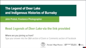
The Legend of Deer Lake and Indigenous histories of Burnaby
https://search.heritageburnaby.ca/link/museumdescription15666
- Repository
- Burnaby Village Museum
- Date
- 4 May 2021
- Collection/Fonds
- Burnaby Village Museum fonds
- Description Level
- Item
- Physical Description
- 1 video recording (mp4) (62 min., 28 sec.) : digital, col., sd., stereo ; 29 fps
- Scope and Content
- Item consists of a video recording of a live Zoom webinar hosted by Adrian Avendaño, Stewardship Program Manager with Still Moon Arts Society. The webinar is presented in partnership with the Burnaby Village Museum, Burnaby Public Library and Still Moon Arts Society. The webinar is titled "The Lege…
- Repository
- Burnaby Village Museum
- Collection/Fonds
- Burnaby Village Museum fonds
- Description Level
- Item
- Physical Description
- 1 video recording (mp4) (62 min., 28 sec.) : digital, col., sd., stereo ; 29 fps
- Material Details
- Presenter: John Preissl
- Host: Adrian Avendano (Still Moon Arts Society)
- Date of Presentation: Tuesday, May 4, 7:00 pm - 8:00 pm
- Total Number of tracks: 1
- Total Length of all tracks: 62 min., 28 sec.
- Recording Device: Zoom video communication platform
- Recording Note: Film was edited from it's original recorded version (77 min., 48 sec.) to edited version (62 min., 28 sec.) for public viewing on Heritage Burnaby.
- Scope and Content
- Item consists of a video recording of a live Zoom webinar hosted by Adrian Avendaño, Stewardship Program Manager with Still Moon Arts Society. The webinar is presented in partnership with the Burnaby Village Museum, Burnaby Public Library and Still Moon Arts Society. The webinar is titled "The Legend of Deer Lake and Indigenous histories of Burnaby" and is presented by John Preissl, Freelance Photographer of Sḵwx̱wú7mesh and Leq’á:mel Nation ancestry. The Zoom webinar is the third in a series of six "Neighbourhood Speaker series" webinars exploring a range of topics shared by Indigenous speakers and knowledge keepers that were presented and made available to the public between April 27 and May 12, 2021. The live webinar was also made available on the Burnaby Village Museum's facebook page. Community members were invited to participate by bringing questions during the interactive online sessions. This webinar was made available in In partnership with Still Moon Arts Society. In this webinar, John Preissl shares his family’s long history from the first Chief Capilano in the late 1700's to the present day. Looking through the lens of his camera, John weaves together stories of the Legend of Deer Lake, resource gathering in the Burnaby Lake Watershed, and protection of the sacred salmon and eagle habitat on the shared homelands of the hən̓q̓əmin̓əm and Sḵwx̱wú7mesh speaking peoples. The presentation is supported with photographs that John has taken over the years documenting the diverse environment and wildlife habitats in Burnaby, the lower mainland and west coast including waterways and the fight to protect it. Following the presentation, John Preissl takes questions from the audience that are moderated by the host, Adrian Avendaño.
- History
- John Preissl is a Burnaby-based environmental, adventure, wildlife and Indigenous freelance photographer. He is a media expert with over two decades of media experience and consulting. John is of Sḵwx̱wú7mesh and Leq’á:mel Nation ancestry. His Great times-two Grandfather was the Great Chief Joe Capilano. John leads many First Nations Tours in Burnaby from Deer Lake, Burnaby Lake, Burnaby Mountain and pretty well all over Sḵwx̱wú7mesh and Tsleil-Waututh Nations Lands.
- Subjects
- Indigenous peoples - British Columbia - Social life and customs
- Animals - Birds
- Animals - Fish
- Geographic Features - Lakes and Ponds
- Geographic Features - Ravines
- Names
- Preissl, John
- Tsleil-Waututh Nation
- Sḵwx̱wú7mesh Nation
- Avendaño, Adrian
- Burnaby Village Museum
- Accession Code
- BV021.17.3
- Access Restriction
- No restrictions
- Reproduction Restriction
- No known restrictions
- Date
- 4 May 2021
- Media Type
- Moving Images
- Historic Neighbourhood
- Burnaby Lake (Historic Neighbourhood)
- Planning Study Area
- Burnaby Lake Area
- Notes
- Title based on content of video recording The following links were shared at the end of the presentation:
- The Legend of Deer Lake: https://www.legendsofvancouver.net/deer-lake-burnaby-vancouver
- Saving the Salmon: the Brunette River Story, a short film about the preservation of Brunette River: https://search.heritageburnaby.ca/permalink/museumvideo4486
- Saving Burnaby Lake, a short film about the preservation of Burnaby Lake: https://search.heritageburnaby.ca/permalink/museumvideo4485
- Still Creek Streamkeepers: https://stillmoonarts.ca/stewardship/streamkeepers/
- John Preissl’s photography website: https://johnpreisslphotography.ca/
Images
Video
The Legend of Deer Lake and Indigenous histories of Burnaby, 4 May 2021
The Legend of Deer Lake and Indigenous histories of Burnaby, 4 May 2021
https://search.heritageburnaby.ca/media/hpo/_Data/_BVM_Moving_Images/2021_0017_0003_002.mp4![Unidentified shoreline, [1905] thumbnail](/media/hpo/_Data/_Archives_Images/_Unrestricted/477/477-116.jpg?width=280)
Unidentified shoreline
https://search.heritageburnaby.ca/link/archivedescription38797
- Repository
- City of Burnaby Archives
- Date
- [1905]
- Collection/Fonds
- Peers Family and Hill Family fonds
- Description Level
- Item
- Physical Description
- 1 photograph : sepia ; 5.5 x 5.5 cm on page 11.5 x 14 cm (pasted in album)
- Scope and Content
- Photograph of a pier in the water next to a rocky outcropping, most likely in the Caulfield area of West Vancouver.
- Repository
- City of Burnaby Archives
- Date
- [1905]
- Collection/Fonds
- Peers Family and Hill Family fonds
- Physical Description
- 1 photograph : sepia ; 5.5 x 5.5 cm on page 11.5 x 14 cm (pasted in album)
- Description Level
- Item
- Record No.
- 477-116
- Access Restriction
- No restrictions
- Reproduction Restriction
- No known restrictions
- Accession Number
- 2007-12
- Scope and Content
- Photograph of a pier in the water next to a rocky outcropping, most likely in the Caulfield area of West Vancouver.
- Media Type
- Photograph
- Notes
- Title based on contents of photograph
Images
![Unidentified shoreline, [1905] thumbnail](/media/hpo/_Data/_Archives_Images/_Unrestricted/477/477-116.jpg)
![Bandsand in Stanley Park, Vancouver, BC, [between 1908 and 1911] thumbnail](/media/hpo/_Data/_BVM_Images/1972/1972_0050_0010_001.jpg?width=280)
Bandsand in Stanley Park, Vancouver, BC
https://search.heritageburnaby.ca/link/museumdescription1071
- Repository
- Burnaby Village Museum
- Date
- [between 1908 and 1911]
- Collection/Fonds
- Burnaby Village Museum Photograph collection
- Description Level
- Item
- Physical Description
- 1 photograph : sepia ; 7.3 x 9.9 cm
- Scope and Content
- Photograph of people walking towards the bandstand in Stanley Park, Vancouver. In 1934, the Malkin Bowl was erected at the site where the banstand used to be. An annotation on the back of the photograph reads, "Band stand in Stanley Park where Malkin Bowl now stands."
- Repository
- Burnaby Village Museum
- Collection/Fonds
- Burnaby Village Museum Photograph collection
- Description Level
- Item
- Physical Description
- 1 photograph : sepia ; 7.3 x 9.9 cm
- Scope and Content
- Photograph of people walking towards the bandstand in Stanley Park, Vancouver. In 1934, the Malkin Bowl was erected at the site where the banstand used to be. An annotation on the back of the photograph reads, "Band stand in Stanley Park where Malkin Bowl now stands."
- Geographic Access
- Vancouver
- Accession Code
- HV972.50.10
- Access Restriction
- No restrictions
- Reproduction Restriction
- No known restrictions
- Date
- [between 1908 and 1911]
- Media Type
- Photograph
- Scan Resolution
- 600
- Scan Date
- 2023-04-04
- Photographer
- Dean, H.M.
- Notes
- Title based on contents of photograph
Images
![Bandsand in Stanley Park, Vancouver, BC, [between 1908 and 1911] thumbnail](/media/hpo/_Data/_BVM_Images/1972/1972_0050_0010_001.jpg)
![Barnet, B.C. from the Hill, [1907] thumbnail](/media/hpo/_Data/_Archives_Images/_Unrestricted/371/411-004.jpg?width=280)
Barnet, B.C. from the Hill
https://search.heritageburnaby.ca/link/archivedescription38345
- Repository
- City of Burnaby Archives
- Date
- [1907]
- Collection/Fonds
- Burnaby Historical Society fonds
- Description Level
- Item
- Physical Description
- 1 photograph : sepia postcard ; 8 x 13 cm
- Scope and Content
- Photograph of the village of Barnet at the mill. The caption stamped at the top of the card reads: "Barnet, B.C. from the Hill." The Barnet Mill was called the North Pacific Lumber Company from 1889 to 1914.
- Repository
- City of Burnaby Archives
- Date
- [1907]
- Collection/Fonds
- Burnaby Historical Society fonds
- Subseries
- Charles Lee subseries
- Physical Description
- 1 photograph : sepia postcard ; 8 x 13 cm
- Description Level
- Item
- Record No.
- 411-004
- Access Restriction
- No restrictions
- Reproduction Restriction
- No known restrictions
- Accession Number
- BHS2000-13
- Scope and Content
- Photograph of the village of Barnet at the mill. The caption stamped at the top of the card reads: "Barnet, B.C. from the Hill." The Barnet Mill was called the North Pacific Lumber Company from 1889 to 1914.
- Subjects
- Documentary Artifacts - Postcards
- Buildings - Industrial - Mills
- Geographic Features - Inlets
- Industries - Forestry
- Industries - Logging/lumber
- Names
- Barnet Mill
- Media Type
- Photograph
- Photographer
- Timms Photographic Co.
- Notes
- Title taken from caption
- Geographic Access
- Barnet Village
- Texaco Drive
- Street Address
- 8059 Texaco Drive
- Historic Neighbourhood
- Barnet (Historic Neighbourhood)
- Planning Study Area
- Burnaby Mountain Area
Images
![Barnet, B.C. from the Hill, [1907] thumbnail](/media/hpo/_Data/_Archives_Images/_Unrestricted/371/411-004.jpg)

Burnaby hospital closes main entrance
https://search.heritageburnaby.ca/link/archivedescription95094
- Repository
- City of Burnaby Archives
- Date
- April 6, 2020
- Collection/Fonds
- Burnaby Photographic Society fonds
- Description Level
- Item
- Physical Description
- 1 photograph (tiff)
- Scope and Content
- Photograph of a rerouting sign posted to a sandwich board outside the Burnaby Hospital emergency lot. The sign states that the hospital entrance is closed and requests visitors use the Main Entrance of the hospital.
- Repository
- City of Burnaby Archives
- Date
- April 6, 2020
- Collection/Fonds
- Burnaby Photographic Society fonds
- Physical Description
- 1 photograph (tiff)
- Description Level
- Item
- Record No.
- 623-013
- Access Restriction
- No restrictions
- Reproduction Restriction
- No restrictions
- Accession Number
- 2020-10
- Scope and Content
- Photograph of a rerouting sign posted to a sandwich board outside the Burnaby Hospital emergency lot. The sign states that the hospital entrance is closed and requests visitors use the Main Entrance of the hospital.
- Subjects
- Buildings - Civic - Hospitals
- Geographic Features - Automobile Parking Lots
- Advertising Medium - Signs and Signboards
- Media Type
- Photograph
- Photographer
- Damer, Eric
- Notes
- Transcribed title
- Geographic Access
- Kincaid Street
- Street Address
- 3935 Kincaid Street
- Historic Neighbourhood
- Broadview (Historic Neighbourhood)
- Planning Study Area
- Cascade-Schou Area
Images

![Canadian Pacific Railway Depot, [between 1908 and 1911] thumbnail](/media/hpo/_Data/_BVM_Images/1972/1972_0050_0005_002.jpg?width=280)
Canadian Pacific Railway Depot
https://search.heritageburnaby.ca/link/museumdescription1066
- Repository
- Burnaby Village Museum
- Date
- [between 1908 and 1911]
- Collection/Fonds
- Burnaby Village Museum Photograph collection
- Description Level
- Item
- Physical Description
- 1 photograph : sepia ; 8.0 x 10.2 cm, mounted on paper 13.5 x 12.2 cm
- Scope and Content
- Photograph of (in the foreground, centre) the Canadian Pacific Railway depot, Vancouver with Burrard Inlet in the background. The north shore can be seen faintly across the water. An annotation reads, "C.P.R. Depot and Burrard Inlet / From Rogers Bldg."
- Repository
- Burnaby Village Museum
- Collection/Fonds
- Burnaby Village Museum Photograph collection
- Description Level
- Item
- Physical Description
- 1 photograph : sepia ; 8.0 x 10.2 cm, mounted on paper 13.5 x 12.2 cm
- Scope and Content
- Photograph of (in the foreground, centre) the Canadian Pacific Railway depot, Vancouver with Burrard Inlet in the background. The north shore can be seen faintly across the water. An annotation reads, "C.P.R. Depot and Burrard Inlet / From Rogers Bldg."
- Accession Code
- HV972.50.5
- Access Restriction
- No restrictions
- Reproduction Restriction
- No known restrictions
- Date
- [between 1908 and 1911]
- Media Type
- Photograph
- Scan Resolution
- 600
- Scan Date
- 2023-03-28
- Photographer
- Dean, H.M.
- Notes
- Title based on contents of photograph
Images
![Canadian Pacific Railway Depot, [between 1908 and 1911] thumbnail](/media/hpo/_Data/_BVM_Images/1972/1972_0050_0005_002.jpg)
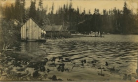
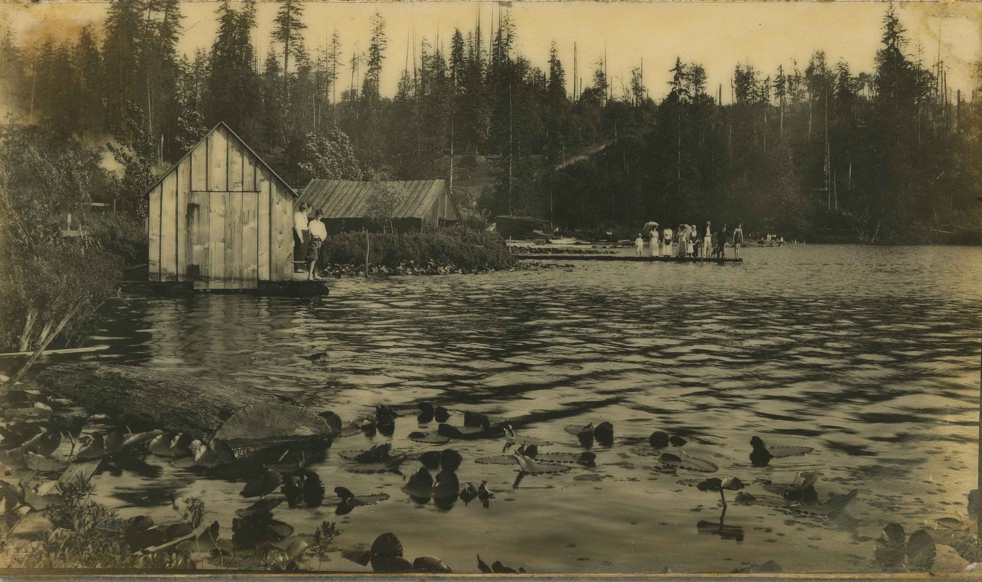
Deer Lake
https://search.heritageburnaby.ca/link/archivedescription34278
- Repository
- City of Burnaby Archives
- Date
- 1904
- Collection/Fonds
- Burnaby Historical Society fonds
- Description Level
- Item
- Physical Description
- 1 photograph : b&w ; 8.1 x 13.8 cm
- Scope and Content
- Photograph of Deer Lake, looking southeast. Three men are standing by a boatshed on the left, a group of people (men, women and children) are standing on a dock, and other people can be seen on the beach in the background.
- Repository
- City of Burnaby Archives
- Date
- 1904
- Collection/Fonds
- Burnaby Historical Society fonds
- Subseries
- Photographs subseries
- Physical Description
- 1 photograph : b&w ; 8.1 x 13.8 cm
- Description Level
- Item
- Record No.
- 014-001
- Access Restriction
- No restrictions
- Reproduction Restriction
- No known restrictions
- Accession Number
- BHS2007-04
- Scope and Content
- Photograph of Deer Lake, looking southeast. Three men are standing by a boatshed on the left, a group of people (men, women and children) are standing on a dock, and other people can be seen on the beach in the background.
- Media Type
- Photograph
- Notes
- Title based on contents of photograph
- Geographic Access
- Deer Lake
- Deer Lake Avenue
- Historic Neighbourhood
- Burnaby Lake (Historic Neighbourhood)
- Planning Study Area
- Morley-Buckingham Area
Images