Narrow Results By
Subject
- Animals - Dogs 2
- Animals - Fowl 1
- Buildings - Commercial 2
- Buildings - Commercial - Stores 1
- Buildings - Commercial - Train Stations 3
- Buildings - Residential - Apartments 1
- Buildings - Residential - Houses 4
- Clothing - Uniforms 1
- Construction - Railroad Construction 3
- Construction Tools and Equipment 2
- Documentary Artifacts - Postcards 4
- Energy Production Tools and Equipment 2
Person / Organization
- Adams, G. 2
- Ancient Order of United Workmen of British Columbia 2
- Anderson, Dr. W.H.B. 2
- Beckett, A. 1
- Brandrith Family 1
- British Columbia Electric Railway Company 26
- British Columbia Mills Timber and Trading Company 2
- Budlong, F.L. 2
- Canadian Pacific Railway Company 4
- Cashmore, T. 2
- Cliff, Charles Edwin 1
- Davey, F. 2
![Interior of British Columbia, [191-] thumbnail](/media/hpo/_Data/_BVM_Images/1987/1987_0049_0002_001.jpg?width=280)
Interior of British Columbia
https://search.heritageburnaby.ca/link/museumdescription140
- Repository
- Burnaby Village Museum
- Date
- [191-]
- Collection/Fonds
- Burnaby Village Museum Photograph collection
- Description Level
- Item
- Physical Description
- 1 photograph : b&w ; 7.5 x 11 cm
- Scope and Content
- Photograph of the landscape in the interior of British Columbia. An unidentified lake is surrounded by sage brush in a hilly area.
- Repository
- Burnaby Village Museum
- Collection/Fonds
- Burnaby Village Museum Photograph collection
- Description Level
- Item
- Physical Description
- 1 photograph : b&w ; 7.5 x 11 cm
- Scope and Content
- Photograph of the landscape in the interior of British Columbia. An unidentified lake is surrounded by sage brush in a hilly area.
- History
- Envelope from donor suggests that the image was taken with a Cameo camera.
- Accession Code
- BV987.49.2
- Access Restriction
- No restrictions
- Reproduction Restriction
- No known restrictions
- Date
- [191-]
- Media Type
- Photograph
- Related Material
- The photograph was printed from negative BV987.49.5, and taken with camera BV987.49.1
- Scan Resolution
- 600
- Scan Date
- 2024-04-02
- Notes
- Title based on contents of photograph
- Note written on verso of photograph reads: "Interior BC"
- Lightly printed on verso of photographic paper is the name "velox" signifying Kodak velox paper from [191-]
Images
![Interior of British Columbia, [191-] thumbnail](/media/hpo/_Data/_BVM_Images/1987/1987_0049_0002_001.jpg)
![Survey and Subdivision plans in New Westminster District Group 1 and Group 2 – Vancouver, ʷməθkʷəy̓əm (Musqueam) Indian Reserve, Burnaby, Surrey
, [1910-1911] thumbnail](/media/hpo/_Data/_BVM_Cartographic_Material/1977/1977_0093_0017_001.jpg?width=280)
Survey and Subdivision plans in New Westminster District Group 1 and Group 2 – Vancouver, ʷməθkʷəy̓əm (Musqueam) Indian Reserve, Burnaby, Surrey
https://search.heritageburnaby.ca/link/museumdescription6986
- Repository
- Burnaby Village Museum
- Date
- [1910-1911]
- Collection/Fonds
- Burnaby Village Museum Map collection
- Description Level
- File
- Physical Description
- 9 plans : 4 plans : blueprint ink on paper + 4 plans : black ink on paper + 1 plan : graphite on paper mounted on 2 sides of cardboard 76 x 102 cm
- Scope and Content
- File consists of a large board of three survey plans in New Westminster District Group 1 mounted on one side and six survey and subdivision plans of District Lot 85, New Westminster District Group 1 mounted on the other side. Side A: 1. Plan : blueprint on paper ; 30.5 x 80 cm. Title reads: "Fras…
- Repository
- Burnaby Village Museum
- Collection/Fonds
- Burnaby Village Museum Map collection
- Description Level
- File
- Physical Description
- 9 plans : 4 plans : blueprint ink on paper + 4 plans : black ink on paper + 1 plan : graphite on paper mounted on 2 sides of cardboard 76 x 102 cm
- Material Details
- Scales vary (One chain equals 792 inches)
- Indexed number on tape on edge of board reads "17"
- Scope and Content
- File consists of a large board of three survey plans in New Westminster District Group 1 mounted on one side and six survey and subdivision plans of District Lot 85, New Westminster District Group 1 mounted on the other side. Side A: 1. Plan : blueprint on paper ; 30.5 x 80 cm. Title reads: "Fraser River Bridge / Plan of South Approach". Plan covers area of land north of the Fraser River and Great Northern Railway with approach for a bridge running through the "ʷməθkʷəy̓əm (Musqueam) Indian Reserve" (ʷməθkʷəy̓əm (Musqueam) First Nation) and lots marked as Dominion Government and the east half of Lot 2 identified as "C. F. Brown" "Plan 851". Plan is identified as "Plan 851 / traced / Mar. 17, 1911". (Geographic location in Vancouver) Scale: 100 feet = 1 inch, Signed by Albert J. Hill / P.L.S." 2. Plan : blueprint on paper ; 36.5 x 35 cm (no title). Includes three plans of lots on the east and west sides of North Road. Note on bottom of blueprint reads: "I.E.B. McKay Surveyor General - hereby certify / that this is a correct tracing from the field / notes of the Royal Engineers on file in the / Lands Department / E.B. McKay (signature) / Surveyor General / Victoria B.C. April 11th 1911" . Plan in top left titled "Page 11 / Vol. 1. / R.E. Notes" covers District Lots east of North Road including Lot 5, Lot 7, Lot 41, Lot 9 and Lot 107 in Coquitlam. Plan in top right corner titled "Page 17 / Vol. 1. / R.E. Notes" covers District Lots east of North Road including Lot 104, Lot 54, Lot 105, Lot 55, Lot 106, Lot 9 and Lot 107 in Coquitlam and Port Moody. Plan in lower left corner titled "Page 15 / Vol. 1 / R.E. Notes" covers District Lots west of North Road including Lot 147, Lot 148, Lot 100, Lot 15 in Burnaby. 3. Plan : blue print on paper ; 29.5 x 41.5 cm. (no formal title). Plan of the North 1/2 of Section 18. Plan covers area in the "North 1/2 of Sec.18 B.5 N RGE 1 W" and "Sec. 18 B.5 N. RGE 1 W" bordered by Section 7, Section 13, Section 17 and Section 19. Bon Accord Road runs through Sec. 18. The plan is signed by surveryor "I.H. Neville Smith... C.E.B.C.L.S. / Mar. 26th 1910" and signed by "Ludwig Pillath". (Geographic location: Surrey) Side B: 1. Plan : blueprint on paper ; 43.5 x 49.5 cm. Title reads: "Plan / of Subdivision / of a Portion / of / Lot 85 / Group One / New Westminster District. Plan covers portion of land east of Deer Lake and Pole Line Road (Sperling Avenue) and south of Hastings Road in District Lot 85 in Burnaby with section 4 and a portion of section 2 coloured in red. Plan is signed by "Albert J. Hill, B.C.L.S." Plan is initialed by: "RB" [sic] (in blue pencil crayon) Scale: 4 chains = 1 inch 2. Plaln : black black ink on linen ; 39 x 37 cm. Title reads: "L.C. Hill's Property, / Burnaby". Plan covers a triangular portion of land east of Pole Line Road (Sperling Avenue) and south of Hastings Road in District Lot 85 in Burnaby. Plan is intitaled by "RB" [sic] (in blue pencil crayon). Scale: 3 chains = 1 mile 3. Plan : graphite on paper ; 23 x 17 cm. Title reads: "Portion of Lot 85 / Gr.1". Plan covers portion of land north east of Deer Lake and west of Pole Line Road (now Sperling Avenue) in District Lot 85 in Burnaby. Plan is stamped in red ink: "Albert J. Hill, Civil Engineer". Plan is initialed by: "RB" [sic] (in blue pencil crayon). Scale: 1 chain = 1 inch 4. Plan : black ink on linen ; 16 x 19 cm. Title reads: "Lot 85". Plan covers the intersection of Pole Line Road (Sperling Avenue) and Hastings Road at the north west section of District Lot 79 and District Lot 85 in Burnaby. Plan is stamped: "A.J. Hill, Civil Engineer" with identitifed in blue pencil crayon. 5. Plan : black ink on paper ; 28.5 x 37 cm. (no formal title) Plan covers an area of land, west of Pole Line Road (Sperling Avenue) and south of Deer Lake in District Lot 85 in Burnaby. Plan is initialed by: "RB" [sic] (in blue pencil crayon) 6. Plan : black ink on paper ; 21 x 34 cm (no formal title). Plan covers an area of land, west of Pole Line Road (Sperling Avenue) and south of Deer Lake in District Lot 85 in Burnaby. Plan is initialed by: "RB" [sic] (in blue pencil crayon)
- Accession Code
- HV977.93.17
- Access Restriction
- No restrictions
- Reproduction Restriction
- No known restrictions
- Date
- [1910-1911]
- Media Type
- Cartographic Material
- Historic Neighbourhood
- Burnaby Lake (Historic Neighbourhood)
- Burquitlam (Historic Neighbourhood)
- Planning Study Area
- Morley-Buckingham Area
- Douglas-Gilpin Area
- Scan Resolution
- 600
- Scan Date
- 2023-06-26
- Notes
- Title based on contents of file
- Scale is measured in chains and feet. (One chain equals 792 inches).
- The term "Lot" also refers to a "District Lot”
- Some plans are stamped: "Albert J. Hill, Civil Engineer / and / Provincial Land Surveyor, / New Westminster, / B.C." and intialed: "RB" [sic]
Zoomable Images
![Survey and Subdivision plans in New Westminster District Group 1 and Group 2 – Vancouver, ʷməθkʷəy̓əm (Musqueam) Indian Reserve, Burnaby, Surrey
, [1910-1911] thumbnail](/media/hpo/_Data/_BVM_Cartographic_Material/1977/1977_0093_0017_003_seadragon/1977_0093_0017_003.jpg?w=280)
Survey and Subdivision plans in New Westminster District Group 1 and Group 2 – Vancouver, ʷməθkʷəy̓əm (Musqueam) Indian Reserve, Burnaby, Surrey , [1910-1911]
Zoom into Image
![Survey and Subdivision plans in New Westminster District Group 1 & Group 2 - Port Moody, Surrey
, [1898-1910] thumbnail](/media/hpo/_Data/_BVM_Cartographic_Material/1977/1977_0093_0073_001.jpg?width=280)
Survey and Subdivision plans in New Westminster District Group 1 & Group 2 - Port Moody, Surrey
https://search.heritageburnaby.ca/link/museumdescription7042
- Repository
- Burnaby Village Museum
- Date
- [1898-1910]
- Collection/Fonds
- Burnaby Village Museum Map collection
- Description Level
- File
- Physical Description
- 10 plans : graphite and ink on paper and linen; various sizes mounted on 2 sides of cardboard 76 x 102 cm
- Scope and Content
- File consists of a large board with four plans in New Westminster District mounted on one side and six plans mounted on the other side. Side A: 1. Plan : black ink and graphite on paper ; 46.5 x 37.5 cm. Title reads: "Bon Accord Hatchery / Sec 6 B5N R1W". Signed by Albert J. Hill P.L.S. August 1…
- Repository
- Burnaby Village Museum
- Collection/Fonds
- Burnaby Village Museum Map collection
- Description Level
- File
- Physical Description
- 10 plans : graphite and ink on paper and linen; various sizes mounted on 2 sides of cardboard 76 x 102 cm
- Material Details
- Scales vary (One chain equals 792 inches)
- Indexed number on tape on edge of board reads "73"
- Scope and Content
- File consists of a large board with four plans in New Westminster District mounted on one side and six plans mounted on the other side. Side A: 1. Plan : black ink and graphite on paper ; 46.5 x 37.5 cm. Title reads: "Bon Accord Hatchery / Sec 6 B5N R1W". Signed by Albert J. Hill P.L.S. August 12, 1903. Plan covers land identified as Section 6, Section 7, Located along the south shore of the Fraser River in Port Mann (Geographic location: Surrey). 2. Plan : black ink and graphite on paper ; 36 x 31 cm. Title reads: "Survey of Portions of Sec. 20 B5N R2W". Plan is stamped in red ink: "Albert J. Hill, Civil Engineer". Scale 4 chains = 1 inch. 3. Plan : black ink on linen ; 14 x 23 cm. Title reads:"Port Moody". Plan covers sections in Lot 191 (District Lot 191) bordered by Burrard Inlet to the west and Lot 235 and Lot 233 to the south. Streets identified include Water Street, Beauregard Street, Yonge Street, Clinton Street and Oxford Street. 4. Plan: graphite and ink on paper ; 43.5 x 64.5 cm. Title reads: "Sketch Plan Approved by Council [sic] / _[sic]1898". (No identifying geographic landmarks provided) Side B: 1. Plan : graphite on paper ; 53.5 x 31 cm. Title reads: "Plan of Lot 13, Gr. II, N.W. Dist". Sketch plan covers area along the Fraser River in District Lot 13, New Westminster District, Group 2. District Lot 13 is bordered by District Lot 14 (to the west) and Lot 12 (to the east). Natural geographic features within District Lot 13 are noted as "dense brush and fallen timber / sallal / rough spruce and cedar / swamp / fine alder / sallal / fine alder bottom land / fine brook". Scale: 3 chains = 1 inch (Geographic location: Surrey) 2. Plan : black ink on paper ; 50.5 x 34.5 cm. Title reads: "Indian Reserve / Opposite / New Westminster". Plan covers area on the south shore of the Fraser River in New Westminster District Group 2 in an area known as Brownsville. Lots are identified as District Lots 1, 2, 3, 4, 18, 17 and 8 and Sections A and B. Two areas of land are noted as "Indian Reserve"; one 6.3 acre parcel and one 104.25 acre parcel, both within District Lot 1. Note on plan reads: "N.B. this plan shows reserves and adjacent properties as they are on the ground". (Geographic location: Surrey) 3. Plan : black and col. ink on paper ; 19.5 x 31.5 cm. Title reads: "Bon Accord Road". Plan shows elevation. "Average section 10 feet = 1 inch". Plan is stamped in red ink: "Albert J. Hill, Civil Engineer and Provincial Land Surveyor, New Westminster, B.C." (Geographic location: Surrey) 4. Plan : black and col. ink on linen ; 16.5 x 25.5 cm. (no formal title) Plan covers area of Section 35, south of Yale Wagon Road and east of Quible Road. Plan is signed by "Albert J. Hill / B.C.L.S." (Geographic location: Surrey) 5. Plan: black and col. ink on linen ; 22.5 x 22.5 cm. (no formal title) Plan covers area between Yale Road and Townline Road in Surrey. Scale: 4 chains = 1 inch. Plan is signed by Albert J. Hill B.C.L.S. [190-] (Geographic location: Surrey) 6. Plan : graphite on paper ; 24 x 54 cm. (no formal title) Plan covers sectioned areas along Bon Accord Road. Sections are identified as " Sec. 8 / T.F. Patterson"; "Sec. 9 / Russell"; "Elliott_Burnett_Crean / Sec. 16"; "Dom. Govt. / Sec. 17". (Geographic location: Surrey, beneath the Port Mann bridge)
- Names
- ʷməθkʷəy̓əm (Musqueam)
- Accession Code
- HV977.93.73
- Access Restriction
- No restrictions
- Reproduction Restriction
- No known restrictions
- Date
- [1898-1910]
- Media Type
- Cartographic Material
- Scan Resolution
- 600
- Scan Date
- 2023-06-26
- Notes
- Title based on contents of file
- Note re plan 2B: The sight of Brownsville was also the former site of the Qayqayt First Nation and one of the main summer villages of the Kwantlen and ʷməθkʷəy̓əm (Musqueam) peoples
Zoomable Images
![Survey and Subdivision plans in New Westminster District Group 1 & Group 2 - Port Moody, Surrey
, [1898-1910] thumbnail](/media/hpo/_Data/_BVM_Cartographic_Material/1977/1977_0093_0073_003_seadragon/1977_0093_0073_003.jpg?w=280)
Survey and Subdivision plans in New Westminster District Group 1 & Group 2 - Port Moody, Surrey , [1898-1910]
Zoom into Image
![Survey and Subdivision plans in New Westminster District Group 2 - Surrey, Delta
, [1898-1910] thumbnail](/media/hpo/_Data/_BVM_Cartographic_Material/1977/1977_0093_0078_001.jpg?width=280)
Survey and Subdivision plans in New Westminster District Group 2 - Surrey, Delta
https://search.heritageburnaby.ca/link/museumdescription7047
- Repository
- Burnaby Village Museum
- Date
- [1898-1910]
- Collection/Fonds
- Burnaby Village Museum Map collection
- Description Level
- File
- Physical Description
- 10 plans : graphite and ink on paper and linen; various sizes mounted on 2 sides of cardboard 76 x 102 cm
- Scope and Content
- File consists of a large board with four plans in New Westminster District mounted on one side and six plans mounted on the other side. Side A: 1. Plan : black ink on paper with colour (no formal title). Plan covers area in New Westminster District, Group 2 situated along the south shore of the …
- Repository
- Burnaby Village Museum
- Collection/Fonds
- Burnaby Village Museum Map collection
- Description Level
- File
- Physical Description
- 10 plans : graphite and ink on paper and linen; various sizes mounted on 2 sides of cardboard 76 x 102 cm
- Material Details
- Scales vary
- Indexed number on tape on edge of board reads "78"
- Scope and Content
- File consists of a large board with four plans in New Westminster District mounted on one side and six plans mounted on the other side. Side A: 1. Plan : black ink on paper with colour (no formal title). Plan covers area in New Westminster District, Group 2 situated along the south shore of the Fraser River identified as "Indian Reserve / Turner 1868" situated in District Lot 1 between District Lot 2 identified as "Mohun's Line" and "Herring's Line" bordered by lots B and A. Includes note "see plan of subdivision of Lots 3 & 4 Gr. 2". (Geographic location: Surrey) 2. Plan : graphite on paper ; Title reads: "B5N R2W, Sec.26_Sec. 28 / Sec. 35_Sec.36". Plan covers a 60 acre parcel in Sec. 35 with Yale wagon road to the south. Scale: 6 chains = 1 inch (Geographic location: Surrey) 3. Plan : black ink on paper ; Title reads: "Survey for Proposed Highway in Indian Reserve Surrey". Plan covers area of land to the northwest of Lot 2 along the shore of the Fraser River and identfies route of proposed highway, proposed tramway as well at the Great Northern Railway and bridge. Scale: 2 chains = 1 inch 4. Plan : black ink on red lined graphing paper ; Title reads: "Sketch Plan Showing Section of Great Northern R. of W. at Point of Crossing of Proposed Ditch". Plan covers area of Lot 2 in New Westminster District, Group 2. (Surrey) Scale: 1 inch = 5 feet. (Geographic location: Surrey) Side B: 1. Plan : black ink on paper ; Title reads: "Plan of Subdivision of a Portion of Section 13, TP2, Surrey Municipality, New Westminster District, B.C.". Plan covers land bordered by Coast Meridian Road (to the east), Bose Road (to the south) and Pike Road (to the west). Surveyed for D.S. Bayners, Nov. 24, 1908. Scale: 5 chains= 1 inch 2. Plan : black ink on linen with colour ; Title reads: "Traverse of the Waterline in front of Lots 3 and 4, Group 2, New Westminster District with G.N. Railway Right of Way". Plan covers area along the southern shore of the Fraser River with a road crossing the Great Northern Railway and leading to a wharf. Scale: 100 feet = 1 inch (Geographic location: Surrey) 3. Plan : black ink on paper ; Title reads: "Survey of the South Boundary of Sec. 12, Township 2, New Westminster District". Plan covers area south of Bose Road and west of Coast Meridean Road and north of McClellen Road. Scale: 400 feet = 1 inch. Sec.12 (Geographic location: Surrey) 4. Plan : graphite on paper ; Title reads: "Plan of Subdivisioin of a part of S.E. 1/4 of Sec. 7, TP 8". Plan covers area of Section 7 in New Westminster District, Group 2, Township 8. Streets are identified running through lot including, Langley Ave., Robinson Ave, Melrose Ave., Hawthorne Ave., Broadway, Bond Ave., Mable Ave., Breene Ave. and McLelland Ave. and Clover Valley Road. Scale: 200 feet = 1 inch. Note in black ink reads: See Bd. 166 for blue print. (Geographic location: Surrey) 5. Plan : graphite on linen ; Title reads: "Sec.20, B5N R2W". Plan covers area north of Yale Road and is subdivided into parts identified as A, B, C, D, E, and unknown. (Geographic location: Surrey) 6. Plan : black ink and graphite on paper ; (no formal title) Plan covers lots surveyed along Ladner Road identified as A, B and Lots 13, 12 and 11. [Geographic location: Delta]
- Accession Code
- HV977.93.78
- Access Restriction
- No restrictions
- Reproduction Restriction
- No known restrictions
- Date
- [1898-1910]
- Media Type
- Cartographic Material
- Scan Resolution
- 600
- Scan Date
- 2023-06-26
- Notes
- Title based on contents of file
- Note re plans 1A & 3A: The sight of Brownsville was also the former site of the Qayqayt First Nation and one of the main summer villages of the Kwantlen and ʷməθkʷəy̓əm (Musqueam) peoples
- Scale is measured in chains and feet. (One chain equals 792 inches)
Zoomable Images
![Survey and Subdivision plans in New Westminster District Group 2 - Surrey, Delta
, [1898-1910] thumbnail](/media/hpo/_Data/_BVM_Cartographic_Material/1977/1977_0093_0078_003_seadragon/1977_0093_0078_003.jpg?w=280)
Survey and Subdivision plans in New Westminster District Group 2 - Surrey, Delta , [1898-1910]
Zoom into Image

Boundary Road and Park Avenue station
https://search.heritageburnaby.ca/link/archivedescription36670
- Repository
- City of Burnaby Archives
- Date
- 1912 (date of original), copied 1992
- Collection/Fonds
- Burnaby Historical Society fonds
- Description Level
- Item
- Physical Description
- 1 photograph : b&w ; 10.1 x 14.9 cm print
- Scope and Content
- Photograph of Boundary Road, Park Avenue Interurban station, and the surrounding area, looking north from Kingsway. The Coburn house, built in 1906, is at the top of the hill on the right, current address 5170 Boundary Road.
- Repository
- City of Burnaby Archives
- Date
- 1912 (date of original), copied 1992
- Collection/Fonds
- Burnaby Historical Society fonds
- Subseries
- Burnaby Centennial Anthology subseries
- Physical Description
- 1 photograph : b&w ; 10.1 x 14.9 cm print
- Description Level
- Item
- Record No.
- 315-025
- Access Restriction
- No restrictions
- Reproduction Restriction
- No known restrictions
- Accession Number
- BHS1994-04
- Scope and Content
- Photograph of Boundary Road, Park Avenue Interurban station, and the surrounding area, looking north from Kingsway. The Coburn house, built in 1906, is at the top of the hill on the right, current address 5170 Boundary Road.
- Media Type
- Photograph
- Notes
- Title based on contents of photograph
- Annotation at bottom of photograph reads; "Boundary Rd and Park Ave Station"
- Geographic Access
- Boundary Road
- Kingsway
- Historic Neighbourhood
- Central Park (Historic Neighbourhood)
- Planning Study Area
- Garden Village Area
Images

![Burnaby Lake Interurban, [before 1954] thumbnail](/media/hpo/_Data/_Archives_Images/_Unrestricted/316/328-001.jpg?width=280)
Burnaby Lake Interurban
https://search.heritageburnaby.ca/link/archivedescription37174
- Repository
- City of Burnaby Archives
- Date
- [before 1954]
- Collection/Fonds
- Burnaby Historical Society fonds
- Description Level
- Item
- Physical Description
- 1 photograph : b&w ; 10 x 13 cm print
- Scope and Content
- Photograph of the Burnaby Lake Interurban in the snow. The house in the background is 2231 Fareham Street, a short street that ran behind Elwell and the tram tracks about midway between the Cumberland Road and Hill Street Stations. This rail line route is now the route of Highway 1 through Burnaby.…
- Repository
- City of Burnaby Archives
- Date
- [before 1954]
- Collection/Fonds
- Burnaby Historical Society fonds
- Subseries
- Photographs subseries
- Physical Description
- 1 photograph : b&w ; 10 x 13 cm print
- Description Level
- Item
- Record No.
- 328-001
- Access Restriction
- No restrictions
- Reproduction Restriction
- Reproduce for fair dealing purposes only
- Accession Number
- BHS1996-14
- Scope and Content
- Photograph of the Burnaby Lake Interurban in the snow. The house in the background is 2231 Fareham Street, a short street that ran behind Elwell and the tram tracks about midway between the Cumberland Road and Hill Street Stations. This rail line route is now the route of Highway 1 through Burnaby. The uppermost window in the house was the donor's bedroom.
- Subjects
- Transportation - Electric Railroads
- Media Type
- Photograph
- Notes
- Title based on contents of photograph
- Geographic Access
- Fareham Avenue
- Historic Neighbourhood
- East Burnaby (Historic Neighbourhood)
- Planning Study Area
- Cariboo-Armstrong Area
Images
![Burnaby Lake Interurban, [before 1954] thumbnail](/media/hpo/_Data/_Archives_Images/_Unrestricted/316/328-001.jpg)
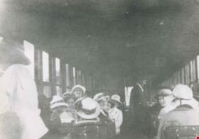
Central Park interurban interior
https://search.heritageburnaby.ca/link/archivedescription37221
- Repository
- City of Burnaby Archives
- Date
- 1910
- Collection/Fonds
- Burnaby Historical Society fonds
- Description Level
- Item
- Physical Description
- 1 photograph : b&w ; 7.5 x 10.5 cm print
- Scope and Content
- Photograph of the interior of a Central Park interurban while it is in service in Vancouver.
- Repository
- City of Burnaby Archives
- Date
- 1910
- Collection/Fonds
- Burnaby Historical Society fonds
- Subseries
- Photographs subseries
- Physical Description
- 1 photograph : b&w ; 7.5 x 10.5 cm print
- Description Level
- Item
- Record No.
- 338-001
- Access Restriction
- No restrictions
- Reproduction Restriction
- No known restrictions
- Accession Number
- BHS2007-04
- Scope and Content
- Photograph of the interior of a Central Park interurban while it is in service in Vancouver.
- Subjects
- Transportation - Electric Railroads
- Media Type
- Photograph
- Notes
- Title based on contents of photograph
Images
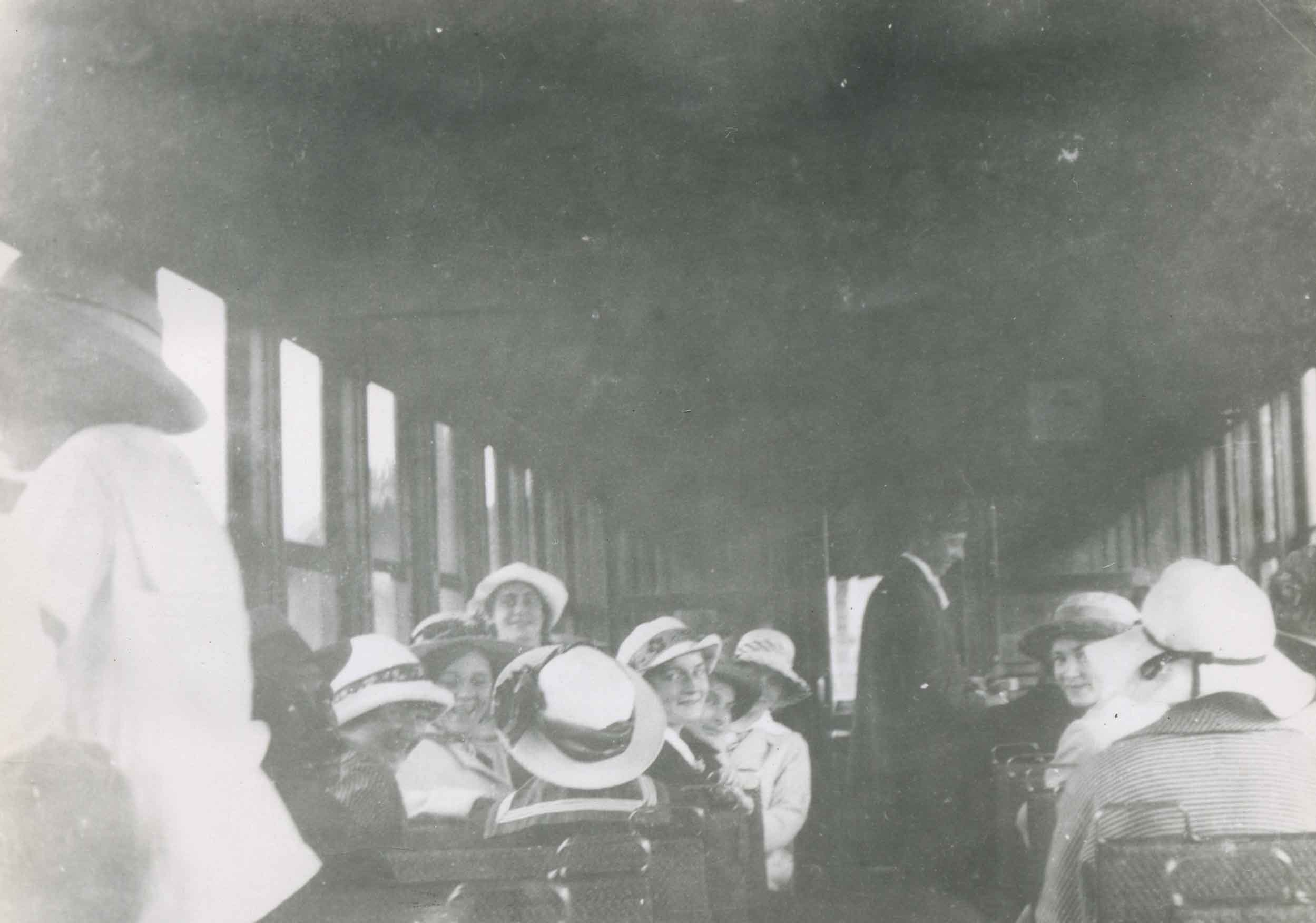
Central Park Interurban tram interior
https://search.heritageburnaby.ca/link/archivedescription34037
- Repository
- City of Burnaby Archives
- Date
- 1910
- Collection/Fonds
- Burnaby Historical Society fonds
- Description Level
- Item
- Physical Description
- 1 photograph : b&w negative ; 8.4 x 11.3 cm
- Scope and Content
- Photograph of the interior of a Central Park Interurban tram, including passengers, the majority of whom are women.
- Repository
- City of Burnaby Archives
- Date
- 1910
- Collection/Fonds
- Burnaby Historical Society fonds
- Subseries
- Stride family subseries
- Physical Description
- 1 photograph : b&w negative ; 8.4 x 11.3 cm
- Description Level
- Item
- Record No.
- 001-013
- Access Restriction
- No restrictions
- Reproduction Restriction
- No known restrictions
- Accession Number
- BHS2007-04
- Scope and Content
- Photograph of the interior of a Central Park Interurban tram, including passengers, the majority of whom are women.
- Subjects
- Transportation - Electric Railroads
- Media Type
- Photograph
- Notes
- Title based on contents of photograph
Images


Construction of the Hastings Streetcar line extension
https://search.heritageburnaby.ca/link/archivedescription57733
- Repository
- City of Burnaby Archives
- Date
- 1913
- Collection/Fonds
- J.W. Phillips fonds
- Description Level
- Item
- Physical Description
- 1 photograph : b&w glass negative ; 11 x 15.5 cm
- Scope and Content
- Photograph of British Columbia Electric Railway Company labourers constructing the Hastings Streetcar line extension along Hastings Street at Holdom. The Dunsford House, home of the Holdom family is visible on the left along with a wooden plank roadway and sidewalk, with the Holdom family standing …
- Repository
- City of Burnaby Archives
- Date
- 1913
- Collection/Fonds
- J.W. Phillips fonds
- Physical Description
- 1 photograph : b&w glass negative ; 11 x 15.5 cm
- Material Details
- Emulsion measures 11 x 15.5 cm on the glass; entire glass plate measures 12 x 16 cm
- Description Level
- Item
- Record No.
- 487-031
- Access Restriction
- No restrictions
- Reproduction Restriction
- No known restrictions
- Accession Number
- 2008-18
- Scope and Content
- Photograph of British Columbia Electric Railway Company labourers constructing the Hastings Streetcar line extension along Hastings Street at Holdom. The Dunsford House, home of the Holdom family is visible on the left along with a wooden plank roadway and sidewalk, with the Holdom family standing on their front porch. Walter Holdom built Tea Rooms (partially visible on the far left) on his property to entertain prospective real estate buyers. This photograph was taken looking east towards Burnaby Mountain.
- Subjects
- Buildings - Residential - Houses
- Transportation - Rail
- Occupations - Railroad Labourers
- Geographic Features - Roads
- Media Type
- Photograph
- Photographer
- Phillips, James William "Jim"
- Notes
- Title based on contents of photograph
- Geographic Access
- Howard Avenue
- Hastings Street
- Street Address
- 5206 Hastings Street
- Historic Neighbourhood
- Capitol Hill (Historic Neighbourhood)
- Planning Study Area
- Capitol Hill Area
Images

Crowd at Edmonds and Kingsway
https://search.heritageburnaby.ca/link/archivedescription35939
- Repository
- City of Burnaby Archives
- Date
- 1912
- Collection/Fonds
- Burnaby Historical Society fonds
- Description Level
- Item
- Physical Description
- 1 photograph : sepia postcard ; 8.9 x 14.0 cm
- Scope and Content
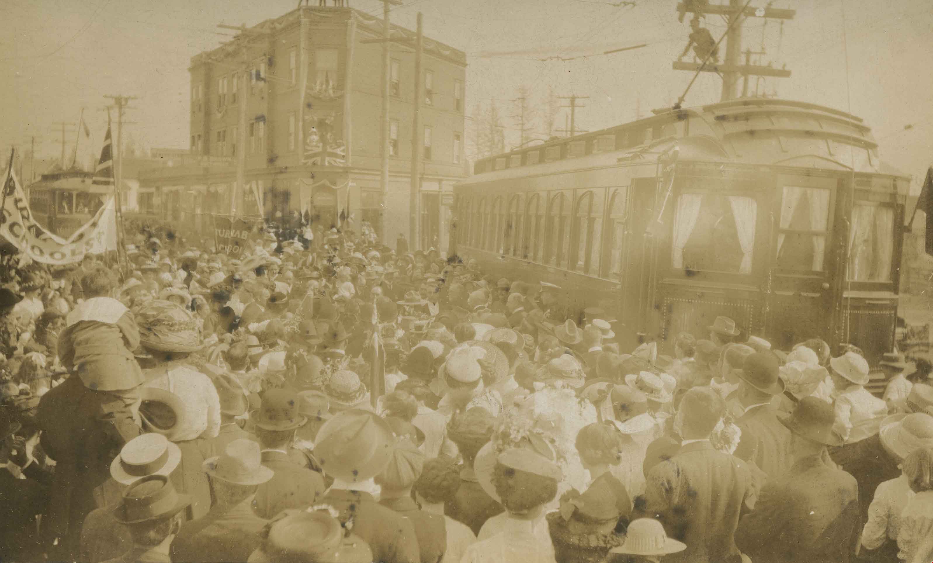
- Photographic postcard of a crowd gathered near a tram car at Edmonds and Kingsway during Prince Arthur, the Duke of Connaught's visit to Burnaby. A Union Jack is hanging from one of the windows of the triangular Edmonds Block, which is visible in the background. The Duke of Connaught was Governor G…
- Repository
- City of Burnaby Archives
- Date
- 1912
- Collection/Fonds
- Burnaby Historical Society fonds
- Subseries
- Pioneer Tales subseries
- Physical Description
- 1 photograph : sepia postcard ; 8.9 x 14.0 cm
- Description Level
- Item
- Record No.
- 204-799
- Access Restriction
- No restrictions
- Reproduction Restriction
- No known restrictions
- Accession Number
- BHS1988-03
- Scope and Content
- Photographic postcard of a crowd gathered near a tram car at Edmonds and Kingsway during Prince Arthur, the Duke of Connaught's visit to Burnaby. A Union Jack is hanging from one of the windows of the triangular Edmonds Block, which is visible in the background. The Duke of Connaught was Governor General of Canada at this time.
- Subjects
- Persons - Crowds
- Transportation - Electric Railroads
- Events - Royal Visits
- Documentary Artifacts - Postcards
- Events - Visits of State
- Media Type
- Photograph
- Notes
- Title based on contents of photograph
- Geographic Access
- Edmonds Street
- Kingsway
- Historic Neighbourhood
- Edmonds (Historic Neighbourhood)
- Planning Study Area
- Richmond Park Area
Images
Crowd at Edmonds and Kingsway
https://search.heritageburnaby.ca/link/museumdescription717
- Repository
- Burnaby Village Museum
- Date
- 1912 (date of original), copied 1976
- Collection/Fonds
- Burnaby Village Museum Photograph collection
- Description Level
- Item
- Physical Description
- 1 photograph : b&w print
- Scope and Content
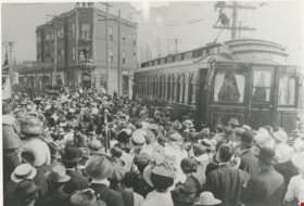
- Photograph of a crowd gathered near a tram car at Edmonds and Kingsway during Prince Arthur, the Duke of Connaught's visit to Burnaby. A Union Jack is hanging from one of the windows of the triangular Edmonds Block, which is visible in the background. The Duke of Connaught was Governor General of C…
- Repository
- Burnaby Village Museum
- Collection/Fonds
- Burnaby Village Museum Photograph collection
- Description Level
- Item
- Physical Description
- 1 photograph : b&w print
- Scope and Content
- Photograph of a crowd gathered near a tram car at Edmonds and Kingsway during Prince Arthur, the Duke of Connaught's visit to Burnaby. A Union Jack is hanging from one of the windows of the triangular Edmonds Block, which is visible in the background. The Duke of Connaught was Governor General of Canada at this time.
- Subjects
- Transportation - Electric Railroads
- Geographic Access
- Edmonds Street
- Kingsway
- Accession Code
- HV976.42.2
- Access Restriction
- No restrictions
- Reproduction Restriction
- May be restricted by third party rights
- Date
- 1912 (date of original), copied 1976
- Media Type
- Photograph
- Historic Neighbourhood
- Edmonds (Historic Neighbourhood)
- Planning Study Area
- Richmond Park Area
- Related Material
- To see photographs from the visit of the Duke of Connaught in 1912, see HV976.152.2 - .5 For another copy of the same image that is cropped differently, see HV977.99.32 The photograph HV977.99.32, from a different source, is also a copy print.
- Scan Resolution
- 600
- Scan Date
- 2023-06-20
- Notes
- Title based on contents of photograph
- Copy print is of an original photographic postcard
Images
![Edmonds and Kingsway, 1912 (date of original), copied [1997] thumbnail](/media/hpo/_Data/_Archives_Images/_Unrestricted/316/350-015.jpg?width=280)
Edmonds and Kingsway
https://search.heritageburnaby.ca/link/archivedescription37321
- Repository
- City of Burnaby Archives
- Date
- 1912 (date of original), copied [1997]
- Collection/Fonds
- Burnaby Historical Society fonds
- Description Level
- Item
- Physical Description
- 1 photograph : b&w ; 9 x 12 cm print
- Scope and Content
- Photograph of the area near the Edmonds and Kingsway intersection. A British Columbia Electric Railway Company tram is visible in the centre and the station can be seen to the left.
- Repository
- City of Burnaby Archives
- Date
- 1912 (date of original), copied [1997]
- Collection/Fonds
- Burnaby Historical Society fonds
- Subseries
- Jim Wolf subseries
- Physical Description
- 1 photograph : b&w ; 9 x 12 cm print
- Description Level
- Item
- Record No.
- 350-015
- Access Restriction
- No restrictions
- Reproduction Restriction
- No known restrictions
- Accession Number
- BHS1997-09
- Scope and Content
- Photograph of the area near the Edmonds and Kingsway intersection. A British Columbia Electric Railway Company tram is visible in the centre and the station can be seen to the left.
- Media Type
- Photograph
- Notes
- Title based on contents of photograph.
- Geographic Access
- Edmonds Street
- Kingsway
- Historic Neighbourhood
- Edmonds (Historic Neighbourhood)
- Planning Study Area
- Richmond Park Area
Images
![Edmonds and Kingsway, 1912 (date of original), copied [1997] thumbnail](/media/hpo/_Data/_Archives_Images/_Unrestricted/316/350-015.jpg)
![Edmonds Interurban station, [1912] (date of original), copied [between 1975 and 1985] thumbnail](/media/hpo/_Data/_Archives_Images/_Unrestricted/001/001-014.jpg?width=280)
Edmonds Interurban station
https://search.heritageburnaby.ca/link/archivedescription34038
- Repository
- City of Burnaby Archives
- Date
- [1912] (date of original), copied [between 1975 and 1985]
- Collection/Fonds
- Burnaby Historical Society fonds
- Description Level
- Item
- Physical Description
- 1 photograph : b&w negative ; 8.2 x 10.8 cm
- Scope and Content
- Photograph of an automobile at the Edmonds Interurban Station. A man appears to be changing the car tires, and three men are on the station platform.
- Repository
- City of Burnaby Archives
- Date
- [1912] (date of original), copied [between 1975 and 1985]
- Collection/Fonds
- Burnaby Historical Society fonds
- Subseries
- Stride family subseries
- Physical Description
- 1 photograph : b&w negative ; 8.2 x 10.8 cm
- Description Level
- Item
- Record No.
- 001-014
- Access Restriction
- No restrictions
- Reproduction Restriction
- No known restrictions
- Accession Number
- BHS2007-04
- Scope and Content
- Photograph of an automobile at the Edmonds Interurban Station. A man appears to be changing the car tires, and three men are on the station platform.
- Subjects
- Buildings - Commercial - Train Stations
- Transportation - Electric Railroads
- Transportation - Automobiles
- Media Type
- Photograph
- Notes
- Title based on contents of photograph
- 1 b&w copy print accompanying
- Geographic Access
- Edmonds Street
- Kingsway
- Historic Neighbourhood
- Edmonds (Historic Neighbourhood)
- Planning Study Area
- Richmond Park Area
Images
![Edmonds Interurban station, [1912] (date of original), copied [between 1975 and 1985] thumbnail](/media/hpo/_Data/_Archives_Images/_Unrestricted/001/001-014.jpg)
![First Burnaby Lake tram through Burnaby Deer Lake station, [1911] thumbnail](/media/hpo/_Data/_Archives_Images/_Unrestricted/477/477-170.jpg?width=280)
First Burnaby Lake tram through Burnaby Deer Lake station
https://search.heritageburnaby.ca/link/archivedescription38851
- Repository
- City of Burnaby Archives
- Date
- [1911]
- Collection/Fonds
- Peers Family and Hill Family fonds
- Description Level
- Item
- Physical Description
- 1 photograph : sepia ; 5.7 x 8 cm
- Scope and Content
- Photograph of the first Interurban tram going though the Deer Lake station in the Burnaby Lake area.
- Repository
- City of Burnaby Archives
- Date
- [1911]
- Collection/Fonds
- Peers Family and Hill Family fonds
- Physical Description
- 1 photograph : sepia ; 5.7 x 8 cm
- Description Level
- Item
- Record No.
- 477-170
- Access Restriction
- No restrictions
- Reproduction Restriction
- No known restrictions
- Accession Number
- 2007-12
- Scope and Content
- Photograph of the first Interurban tram going though the Deer Lake station in the Burnaby Lake area.
- Media Type
- Photograph
- Notes
- Title based on caption accompanying photograph
- Geographic Access
- Burnaby Lake Interurban line
- Historic Neighbourhood
- Burnaby Lake (Historic Neighbourhood)
- Planning Study Area
- Burnaby Lake Area
Images
![First Burnaby Lake tram through Burnaby Deer Lake station, [1911] thumbnail](/media/hpo/_Data/_Archives_Images/_Unrestricted/477/477-170.jpg)
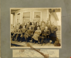
Grand Lodge officers
https://search.heritageburnaby.ca/link/museumdescription1094
- Repository
- Burnaby Village Museum
- Date
- March 10, 1911
- Collection/Fonds
- Burnaby Village Museum Photograph collection
- Description Level
- Item
- Physical Description
- 1 photograph : sepia ; 19 x 24.5 cm, mounted on card 30 x 35 cm
- Scope and Content
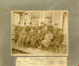
- Photograph of Grand Lodge officers of the Ancient Order of United Workmen of British Columbia. Standing in the back row (from left) are; F. Davey, C. Wrigglesworth, Past Grand Master Workman F.L. Budlong, Past Grand Master Workman W.H. Smith, Past Grand Master Workman and Grand Trustee Alex. Stewar…
- Repository
- Burnaby Village Museum
- Collection/Fonds
- Burnaby Village Museum Photograph collection
- Description Level
- Item
- Physical Description
- 1 photograph : sepia ; 19 x 24.5 cm, mounted on card 30 x 35 cm
- Scope and Content
- Photograph of Grand Lodge officers of the Ancient Order of United Workmen of British Columbia. Standing in the back row (from left) are; F. Davey, C. Wrigglesworth, Past Grand Master Workman F.L. Budlong, Past Grand Master Workman W.H. Smith, Past Grand Master Workman and Grand Trustee Alex. Stewart and Grand Organizer L. Fenwick Dickson. Standing in the middle row (from left) are; Past Grand Master Workman G. Adams and Grand Treasurer W. Scrowcroft. Sitting in the front row are; Grand Overseer W.H. Wilson, Grand Foreman Dr. W.H.B. Anderson, Grand Master Workman T. Cashmore, Past Grand Master Workman S.M. Everleigh and Grand Secretary J.J. McIlmoyl.
- Names
- Ancient Order of United Workmen of British Columbia
- Davey, F.
- Wrigglesworth, C.
- Budlong, F.L.
- Smith, W.H.
- Stewart, Alexander "Alex"
- Dickson, L. Fenwick
- Adams, G.
- Scrowcroft, W.
- Wilson, W.H.
- Anderson, Dr. W.H.B.
- Cashmore, T.
- Everleigh, S.M.
- McIlmoyl, J.J.
- Accession Code
- HV972.122.68
- Access Restriction
- No restrictions
- Date
- March 10, 1911
- Media Type
- Photograph
- Scan Resolution
- 600
- Scan Date
- 1/8/2010
- Scale
- 100
- Notes
- Typed caption attached to recto of card mount (at bottom) provides title and identifies individuals
Images

Grand Lodge officers and representatives
https://search.heritageburnaby.ca/link/museumdescription1095
- Repository
- Burnaby Village Museum
- Date
- March 1911
- Collection/Fonds
- Burnaby Village Museum Photograph collection
- Description Level
- Item
- Physical Description
- 1 photograph : sepia ; 19 x 24.5 cm, mounted on card 30 x 35 cm
- Scope and Content
- Photograph of Grand Lodge officers and representatives of the Ancient Order of United Workmen of British Columbia at a session in Ladner, British Columbia. Standing in the back row (from left) are; F. Davey, R.D. Featherstonhaugh, Past Grand Master Workman F.L. Budlong, E. Pope, J, Nightingale and…
- Repository
- Burnaby Village Museum
- Collection/Fonds
- Burnaby Village Museum Photograph collection
- Description Level
- Item
- Physical Description
- 1 photograph : sepia ; 19 x 24.5 cm, mounted on card 30 x 35 cm
- Scope and Content
- Photograph of Grand Lodge officers and representatives of the Ancient Order of United Workmen of British Columbia at a session in Ladner, British Columbia. Standing in the back row (from left) are; F. Davey, R.D. Featherstonhaugh, Past Grand Master Workman F.L. Budlong, E. Pope, J, Nightingale and W. Minthorne. Standing in the third row are; C. Wrigglesworth, Past Grand Master Workman W.H. Smith, Past Grand Master Workman and Grand Trustee Alex. Stewart, Grand Treasurer W. Scrowcroft and Grand Organizer L. Fenwick Dickson. Standing in the second row (from left) are; Dr. A.A. King, A. Beckett, T. Todd, A. Harrison, W.F. Graham, Past Grand Master Workman G. Adams and Past Grand Master Workman Captain Warren. Sitting in the front row are; Grand Overseer W.H. Wilson, Grand Foreman Dr. W.H.B. Anderson, Grand Master Workman T. Cashmore, Past Grand Master Workman S.M. Everleigh, Grand Secretary J.J. McIlmoyl and S. Knarston.
- Names
- Ancient Order of United Workmen of British Columbia
- Davey, F.
- Wrigglesworth, C.
- Budlong, F.L.
- Smith, W.H.
- Stewart, Alexander "Alex"
- Dickson, L. Fenwick
- Adams, G.
- Scrowcroft, W.
- Wilson, W.H.
- Anderson, Dr. W.H.B.
- Cashmore, T.
- Everleigh, S.M.
- McIlmoyl, J.J.
- Featherstonhaugh, R.D.
- Pope, E.
- Nightingale, J.
- Minthorne, W.
- King, Dr. A.A.
- Beckett, A.
- Todd, T.
- Harrison, A.
- Graham, W.F.
- Knarston, S.
- Accession Code
- HV972.122.69
- Access Restriction
- No restrictions
- Date
- March 1911
- Media Type
- Photograph
- Scan Resolution
- 600
- Scan Date
- 1/8/2010
- Scale
- 100
- Notes
- Typed caption attached to recto of card mount (at bottom) provides title and identifies individuals
Images

![Hastings Streetcar, [1913 or 1914] thumbnail](/media/hpo/_Data/_Archives_Images/_Unrestricted/487/487-001.jpg?width=280)
Hastings Streetcar
https://search.heritageburnaby.ca/link/archivedescription57695
- Repository
- City of Burnaby Archives
- Date
- [1913 or 1914]
- Collection/Fonds
- J.W. Phillips fonds
- Description Level
- Item
- Physical Description
- 1 photograph : b&w glass negative ; 11 x 15.5 cm
- Scope and Content
- Photograph of the Hastings Streetcar taken at the terminus of the Hastings Streetcar line at Ellesmere Avenue in North Burnaby. Two men in uniform and a boy dressed in a suit and hat are at the head of the car, looking towards the camera. A horse-drawn cart full of cordwood is visible in the backgr…
- Repository
- City of Burnaby Archives
- Date
- [1913 or 1914]
- Collection/Fonds
- J.W. Phillips fonds
- Physical Description
- 1 photograph : b&w glass negative ; 11 x 15.5 cm
- Material Details
- Emulsion measures 11 x 15 cm on the glass; entire glass plate measures 12 x 16 cm
- Description Level
- Item
- Record No.
- 487-001
- Access Restriction
- No restrictions
- Reproduction Restriction
- No known restrictions
- Accession Number
- 2008-18
- Scope and Content
- Photograph of the Hastings Streetcar taken at the terminus of the Hastings Streetcar line at Ellesmere Avenue in North Burnaby. Two men in uniform and a boy dressed in a suit and hat are at the head of the car, looking towards the camera. A horse-drawn cart full of cordwood is visible in the background moving along the planked wooden road parallel to the street car.
- Subjects
- Transportation - Electric Railroads
- Transportation - Public Transit
- Occupations - Railroad Conductors
- Media Type
- Photograph
- Photographer
- Phillips, James William "Jim"
- Notes
- Title based on contents of photograph
- Geographic Access
- Hastings Street
- Ellesmere Avenue
- Historic Neighbourhood
- Capitol Hill (Historic Neighbourhood)
- Planning Study Area
- Capitol Hill Area
Images
![Hastings Streetcar, [1913 or 1914] thumbnail](/media/hpo/_Data/_Archives_Images/_Unrestricted/487/487-001.jpg)
![Hastings Streetcar, [1913 or 1914] thumbnail](/media/hpo/_Data/_Archives_Images/_Unrestricted/487/487-002.jpg?width=280)
Hastings Streetcar
https://search.heritageburnaby.ca/link/archivedescription57699
- Repository
- City of Burnaby Archives
- Date
- [1913 or 1914]
- Collection/Fonds
- J.W. Phillips fonds
- Description Level
- Item
- Physical Description
- 1 photograph : b&w glass negative ; 11 x 15.5 cm
- Scope and Content
- Photograph of the Hastings Streetcar taken at the terminus of the Hastings Streetcar line at Ellesmere Avenue in North Burnaby. Two men in uniform are at the doorway of the car, while other men are at the platform, wearing three-piece suits and hats; one of these men is standing on the protective s…
- Repository
- City of Burnaby Archives
- Date
- [1913 or 1914]
- Collection/Fonds
- J.W. Phillips fonds
- Physical Description
- 1 photograph : b&w glass negative ; 11 x 15.5 cm
- Material Details
- Emulsion measures 11 x 15.5 cm on the glass; entire glass plate measures 12 x 16 cm
- Light leaks present on negative
- Description Level
- Item
- Record No.
- 487-002
- Access Restriction
- No restrictions
- Reproduction Restriction
- No known restrictions
- Accession Number
- 2008-18
- Scope and Content
- Photograph of the Hastings Streetcar taken at the terminus of the Hastings Streetcar line at Ellesmere Avenue in North Burnaby. Two men in uniform are at the doorway of the car, while other men are at the platform, wearing three-piece suits and hats; one of these men is standing on the protective shield in front of the streetcar. A boy in long boots is standing on the far left, and a young woman is at center, with her hands clenched together in front of her waist.
- Subjects
- Transportation - Electric Railroads
- Transportation - Public Transit
- Occupations - Railroad Conductors
- Media Type
- Photograph
- Photographer
- Phillips, James William "Jim"
- Notes
- Title based on contents of photograph
- Geographic Access
- Hastings Street
- Ellesmere Avenue
- Historic Neighbourhood
- Capitol Hill (Historic Neighbourhood)
- Planning Study Area
- Capitol Hill Area
Images
![Hastings Streetcar, [1913 or 1914] thumbnail](/media/hpo/_Data/_Archives_Images/_Unrestricted/487/487-002.jpg)
![Hastings Streetcar, [1913 or 1914] thumbnail](/media/hpo/_Data/_Archives_Images/_Unrestricted/487/487-007.jpg?width=280)
Hastings Streetcar
https://search.heritageburnaby.ca/link/archivedescription57703
- Repository
- City of Burnaby Archives
- Date
- [1913 or 1914]
- Collection/Fonds
- J.W. Phillips fonds
- Description Level
- Item
- Physical Description
- 1 photograph : b&w glass negative ; 11 x 15.5 cm
- Scope and Content
- Photograph of the Hastings Streetcar taken at the terminus of the Hastings Streetcar line at Ellesmere Avenue in North Burnaby. Two men in uniform are at the doorway of the car, while other men are at the platform, wearing three-piece suits and hats; one of these men is standing on the protective s…
- Repository
- City of Burnaby Archives
- Date
- [1913 or 1914]
- Collection/Fonds
- J.W. Phillips fonds
- Physical Description
- 1 photograph : b&w glass negative ; 11 x 15.5 cm
- Material Details
- Emulsion measures 11 x 15.5 cm on the glass; entire glass plate measures 12 x 16 cm
- Description Level
- Item
- Record No.
- 487-007
- Access Restriction
- No restrictions
- Reproduction Restriction
- No known restrictions
- Accession Number
- 2008-18
- Scope and Content
- Photograph of the Hastings Streetcar taken at the terminus of the Hastings Streetcar line at Ellesmere Avenue in North Burnaby. Two men in uniform are at the doorway of the car, while other men are at the platform, wearing three-piece suits and hats; one of these men is standing on the protective shield in front of the streetcar. A boy in long boots is standing on the far left, beside a young woman with her hands clenched together in front of her waist.
- Subjects
- Transportation - Electric Railroads
- Transportation - Public Transit
- Occupations - Railroad Conductors
- Media Type
- Photograph
- Photographer
- Phillips, James William "Jim"
- Notes
- Title based on contents of photograph
- Geographic Access
- Hastings Street
- Ellesmere Avenue
- Historic Neighbourhood
- Capitol Hill (Historic Neighbourhood)
- Planning Study Area
- Capitol Hill Area
Images
![Hastings Streetcar, [1913 or 1914] thumbnail](/media/hpo/_Data/_Archives_Images/_Unrestricted/487/487-007.jpg)
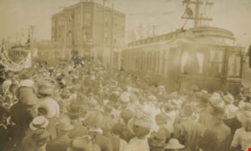
![Large crowd at Edmonds and Kingsway, 1912 (date of original), copied [1997] thumbnail](/media/hpo/_Data/_Archives_Images/_Unrestricted/316/350-021.jpg?width=280)
Large crowd at Edmonds and Kingsway
https://search.heritageburnaby.ca/link/archivedescription37327
- Repository
- City of Burnaby Archives
- Date
- 1912 (date of original), copied [1997]
- Collection/Fonds
- Burnaby Historical Society fonds
- Description Level
- Item
- Physical Description
- 1 photograph : b&w ; 9 x 12 cm print
- Scope and Content
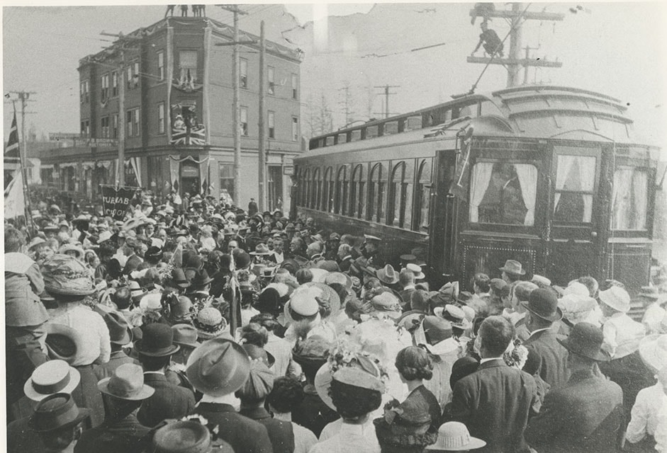
- Photograph of a large crowd gathered near Edmonds and Kingsway to welcome the Duke of Connaught during his visit to Burnaby. Two interurban cars can be seen in the background. The Duke of Connaught was Governor General of Canada at this time.
- Repository
- City of Burnaby Archives
- Date
- 1912 (date of original), copied [1997]
- Collection/Fonds
- Burnaby Historical Society fonds
- Subseries
- Jim Wolf subseries
- Physical Description
- 1 photograph : b&w ; 9 x 12 cm print
- Description Level
- Item
- Record No.
- 350-021
- Access Restriction
- No restrictions
- Reproduction Restriction
- No known restrictions
- Accession Number
- BHS1997-09
- Scope and Content
- Photograph of a large crowd gathered near Edmonds and Kingsway to welcome the Duke of Connaught during his visit to Burnaby. Two interurban cars can be seen in the background. The Duke of Connaught was Governor General of Canada at this time.
- Subjects
- Persons - Crowds
- Transportation - Electric Railroads
- Events - Royal Visits
- Events - Visits of State
- Media Type
- Photograph
- Notes
- Title based on contents of photograph
- Geographic Access
- Edmonds Street
- Kingsway
- Historic Neighbourhood
- Edmonds (Historic Neighbourhood)
- Planning Study Area
- Edmonds Area
Images
![Large crowd at Edmonds and Kingsway, 1912 (date of original), copied [1997] thumbnail](/media/hpo/_Data/_Archives_Images/_Unrestricted/316/350-021.jpg)