Narrow Results By
Decade
- 2020s 83
- 2010s 48
- 2000s 1744
- 1990s 2225
- 1980s 935
- 1970s 1989
- 1960s 964
- 1950s
- 1940s 1215
- 1930s 1144
- 1920s 1616
- 1910s 1280
- 1900s 443
- 1890s 150
- 1880s 136
- 1870s 61
- 1860s 110
- 1850s 9
- 1840s 3
- 1830s 2
- 1820s 2
- 1810s 3
- 1800s 3
- 1790s 2
- 1780s 2
- 1770s 2
- 1760s 2
- 1750s 2
- 1740s 2
- 1730s 2
- 1720s 2
- 1710s 2
- 1700s 2
- 1690s 2
- 1680s
- 1670s 1
- 1660s 1
- 1650s 1
- 1640s 1
- 1630s 1
- 1620s 1
- 1610s 1
- 1600s 1
- 1590s 1
- 1580s 1
- 1570s 1
- 1560s 1
- 1550s 1
- 1540s 1
- 1530s 1
- 1520s 1
- 1510s 1
- 1500s 1
- 1490s 1
- 1480s 1
Subject
- Accidents - Automobile Accidents 2
- Adornment - Jewelry 2
- Advertising Medium 2
- Advertising Medium - Signs and Signboards 12
- Aerial Photographs 15
- Agricultural Tools and Equipment 3
- Agriculture - Farms 25
- Agriculture - Fruit and Berries 3
- Agriculture - Poultry 1
- Animals - Birds 10
- Animals - Cats 1
- Animals - Deer 1

Westridge School
https://search.heritageburnaby.ca/link/landmark676
- Repository
- Burnaby Heritage Planning
- Geographic Access
- Duncan Avenue
- Associated Dates
- 1953
- Heritage Value
- The building boom in Burnaby during the first few years of the 1950s resulted in many new subdivisions being created in previously unoccupied areas of Burnaby. One such neighbourhood was the Westridge area. In 1951, the Inspector of Schools noted in a report that there were 475 new homes in Westridge with another 100 under development. As a result, enrolment pressures were particularly heavy in this area and the School Board opened the Westridge Elementary School in 1953.
- Historic Neighbourhood
- Lochdale (Historic Neighbourhood)
- Planning Study Area
- Westridge Area
- Street Address
- 510 Duncan Avenue
- Street View URL
- Google Maps Street View
Images


Willingdon Heights Neighbourhood
https://search.heritageburnaby.ca/link/landmark670
- Repository
- Burnaby Heritage Planning
- Associated Dates
- 1925-1954
- Heritage Value
- Willingdon Heights was another new subdivision developed in Burnaby during the post-World War Two building boom. A brochure about the development published in 1948 proclaimed "the Willingdon Heights 500 home development project in Burnaby fulfills its promise to provide a self-contained community for former members of the armed services and their families...the largest single veteran housing project in Canada as far as homes for individual ownership is concerned, Willingdon Heights development was planned by the Central Mortgage and Housing Corporation...At this date the earlier built rows of homes have passable roads and the owners are improving lawns and gardens in spare time...eventually additional stores and professional services will be installed and recreational projects will add to the amenities of a community of congenial residents..."
- Planning Study Area
- Willingdon Heights Area
Images


Willingdon Heights Neighbourhood
https://search.heritageburnaby.ca/link/landmark777
- Repository
- Burnaby Heritage Planning
- Associated Dates
- 1955-2008
- Heritage Value
- The convenient location of Willingdon Heights to the Trans Canada Highway, Lougheed Highway and Hastings Street has fostered its development as a primarily residential commuter neighbourhood. Characterised in the post-World War Two period by predominantly single-family developments, the neighbourhood has retained this identity despite some higher density apartment buildings now found there.
- Planning Study Area
- Willingdon Heights Area
Images


Willingdon Heights United Church
https://search.heritageburnaby.ca/link/landmark658
- Repository
- Burnaby Heritage Planning
- Description
- Church building.
- Associated Dates
- 1951
- Street View URL
- Google Maps Street View
- Repository
- Burnaby Heritage Planning
- Geographic Access
- Parker Street
- Associated Dates
- 1951
- Description
- Church building.
- Heritage Value
- This church was built to serve a 500-home subdivision known as Willingdon Heights–Canada’s largest single veteran’s housing project created by the Central Mortgage and Housing Corporation and constructed by the Whitsell Construction Company in 1948. The church building was designed as a simplified Gothic Revival church with a tall front tower and Gothic pointed-arch stained glass window and entrance. This church was designed by Vancouver architects Twizell & Twizell. Both Robert Twizell (1875-1964) and younger brother George Twizell (1885-1957) articled at Newcastle, England’s Hicks & Charlewood before arriving in Vancouver in late 1907 or early 1908, with George working for Robert until they established a partnership a few years later. Their firm lasted for nearly half a century and was well known for its numerous church designs.
- Locality
- Vancouver Heights
- Historic Neighbourhood
- Vancouver Heights (Historic Neighbourhood)
- Planning Study Area
- Willingdon Heights Area
- Architect
- Twizell & Twizell
- Area
- 1808.82
- Contributing Resource
- Building
- Ownership
- Private
- Street Address
- 4304 Parker Street
- Street View URL
- Google Maps Street View
Images


Windsor Neighbourhood
https://search.heritageburnaby.ca/link/landmark803
- Repository
- Burnaby Heritage Planning
- Associated Dates
- 1955-2008
- Heritage Value
- The Windsor Neighbourhood comprises a number of different districts with different characteristics. To the north, stretching to the border of the Deer Lake Park, is the primarily residential area that was developed after the building boom of the 1950s and now consists of a mix of single-family and multi-family housing. To the south, from Kingsway to the Skytrain line, an industrial area was maintained along with a significant commercial corridor along Kingsway. In recent years, the growth and development of this area has been guided by the Royal Oak Community Plan adopted by Council in 1999.
- Planning Study Area
- Windsor Area
Images

![311 Madison Avenue, [1949 or 1950] (date of original), copied 1991 thumbnail](/media/hpo/_Data/_Archives_Images/_Unrestricted/370/370-204.jpg?width=280)
311 Madison Avenue
https://search.heritageburnaby.ca/link/archivedescription37616
- Repository
- City of Burnaby Archives
- Date
- [1949 or 1950] (date of original), copied 1991
- Collection/Fonds
- Burnaby Historical Society fonds
- Description Level
- Item
- Physical Description
- 1 photograph : b&w ; 3.0 x 4.5 cm print on contact sheet 20.2 x 25.3 cm
- Scope and Content
- Photograph of a side view of 311 Madison Avenue, in the snow. The photograph was taken from Madison Avenue.
- Repository
- City of Burnaby Archives
- Date
- [1949 or 1950] (date of original), copied 1991
- Collection/Fonds
- Burnaby Historical Society fonds
- Subseries
- Burnaby Image Bank subseries
- Physical Description
- 1 photograph : b&w ; 3.0 x 4.5 cm print on contact sheet 20.2 x 25.3 cm
- Description Level
- Item
- Record No.
- 370-204
- Access Restriction
- No restrictions
- Reproduction Restriction
- No restrictions
- Accession Number
- BHS1999-03
- Scope and Content
- Photograph of a side view of 311 Madison Avenue, in the snow. The photograph was taken from Madison Avenue.
- Media Type
- Photograph
- Notes
- Title based on contents of photograph
- 1 b&w copy negative accompanying
- Geographic Access
- Madison Avenue
- Street Address
- 311 Madison Avenue
- Historic Neighbourhood
- Vancouver Heights (Historic Neighbourhood)
- Planning Study Area
- Burnaby Heights Area
Images
![311 Madison Avenue, [1949 or 1950] (date of original), copied 1991 thumbnail](/media/hpo/_Data/_Archives_Images/_Unrestricted/370/370-204.jpg)
![335 16th Avenue, [between 1950 and 1954] (date of original), copied 1991 thumbnail](/media/hpo/_Data/_Archives_Images/_Unrestricted/370/370-430.jpg?width=280)
335 16th Avenue
https://search.heritageburnaby.ca/link/archivedescription37842
- Repository
- City of Burnaby Archives
- Date
- [between 1950 and 1954] (date of original), copied 1991
- Collection/Fonds
- Burnaby Historical Society fonds
- Description Level
- Item
- Physical Description
- 1 photograph : b&w ; 2.6 x 4.6 cm print on contact sheet 20.6 x 26.7 cm
- Scope and Content
- Photograph of 335 16th Avenue (later renumbered 8029 16th Avenue), the home of Mel and Lois Coutts from 1948 to 1955.
- Repository
- City of Burnaby Archives
- Date
- [between 1950 and 1954] (date of original), copied 1991
- Collection/Fonds
- Burnaby Historical Society fonds
- Subseries
- Burnaby Image Bank subseries
- Physical Description
- 1 photograph : b&w ; 2.6 x 4.6 cm print on contact sheet 20.6 x 26.7 cm
- Description Level
- Item
- Record No.
- 370-430
- Access Restriction
- No restrictions
- Reproduction Restriction
- No restrictions
- Accession Number
- BHS1999-03
- Scope and Content
- Photograph of 335 16th Avenue (later renumbered 8029 16th Avenue), the home of Mel and Lois Coutts from 1948 to 1955.
- Subjects
- Buildings - Residential - Houses
- Media Type
- Photograph
- Notes
- Title based on contents of photograph
- 1 b&w copy negative accompanying
- Negative has a pink cast
- Geographic Access
- 16th Avenue
- Street Address
- 8029 16th Avenue
- Historic Neighbourhood
- East Burnaby (Historic Neighbourhood)
- Planning Study Area
- Second Street Area
Images
![335 16th Avenue, [between 1950 and 1954] (date of original), copied 1991 thumbnail](/media/hpo/_Data/_Archives_Images/_Unrestricted/370/370-430.jpg)
![1000 Block Gilley Avenue, [1955] (date of original), copied 1991 thumbnail](/media/hpo/_Data/_Archives_Images/_Unrestricted/370/370-672.jpg?width=280)
1000 Block Gilley Avenue
https://search.heritageburnaby.ca/link/archivedescription38085
- Repository
- City of Burnaby Archives
- Date
- [1955] (date of original), copied 1991
- Collection/Fonds
- Burnaby Historical Society fonds
- Description Level
- Item
- Physical Description
- 1 photograph : b&w ; 3.1 x 3.0 cm print on contact sheet 21.5 x 26.8 cm
- Scope and Content
- Photograph of the 1000 block of Gilley Avenue (later renumbered the 8000 block) looking south towards Marine Drive in the snow.
- Repository
- City of Burnaby Archives
- Date
- [1955] (date of original), copied 1991
- Collection/Fonds
- Burnaby Historical Society fonds
- Subseries
- Burnaby Image Bank subseries
- Physical Description
- 1 photograph : b&w ; 3.1 x 3.0 cm print on contact sheet 21.5 x 26.8 cm
- Description Level
- Item
- Record No.
- 370-672
- Access Restriction
- No restrictions
- Reproduction Restriction
- No restrictions
- Accession Number
- BHS1999-03
- Scope and Content
- Photograph of the 1000 block of Gilley Avenue (later renumbered the 8000 block) looking south towards Marine Drive in the snow.
- Media Type
- Photograph
- Notes
- Title based on contents of photograph
- 1 b&w copy negative accompanying
- Negative has a pink cast
- Geographic Access
- Gilley Avenue
- Planning Study Area
- Clinton-Glenwood Area
- Stride Hill Area
Images
![1000 Block Gilley Avenue, [1955] (date of original), copied 1991 thumbnail](/media/hpo/_Data/_Archives_Images/_Unrestricted/370/370-672.jpg)
![1007 Gilley Avenue, [1949 or 1950] (date of original), copied 1991 thumbnail](/media/hpo/_Data/_Archives_Images/_Unrestricted/370/370-667.jpg?width=280)
1007 Gilley Avenue
https://search.heritageburnaby.ca/link/archivedescription38080
- Repository
- City of Burnaby Archives
- Date
- [1949 or 1950] (date of original), copied 1991
- Collection/Fonds
- Burnaby Historical Society fonds
- Description Level
- Item
- Physical Description
- 1 photograph : b&w ; 3.0 x 3.0 cm print on contact sheet 20.2 x 26.2 cm
- Scope and Content
- Photograph of the back of 1007 Gilley Avenue (later renumbered 8416 Gilley Avenue).
- Repository
- City of Burnaby Archives
- Date
- [1949 or 1950] (date of original), copied 1991
- Collection/Fonds
- Burnaby Historical Society fonds
- Subseries
- Burnaby Image Bank subseries
- Physical Description
- 1 photograph : b&w ; 3.0 x 3.0 cm print on contact sheet 20.2 x 26.2 cm
- Description Level
- Item
- Record No.
- 370-667
- Access Restriction
- No restrictions
- Reproduction Restriction
- No restrictions
- Accession Number
- BHS1999-03
- Scope and Content
- Photograph of the back of 1007 Gilley Avenue (later renumbered 8416 Gilley Avenue).
- Subjects
- Buildings - Residential - Houses
- Media Type
- Photograph
- Notes
- Title based on contents of photograph
- 1 b&w copy negative accompanying
- Negative has a pink cast
- Geographic Access
- Gilley Avenue
- Street Address
- 8416 Gilley Avenue
- Planning Study Area
- Stride Hill Area
Images
![1007 Gilley Avenue, [1949 or 1950] (date of original), copied 1991 thumbnail](/media/hpo/_Data/_Archives_Images/_Unrestricted/370/370-667.jpg)
![1520 Mary Avenue, [1951] (date of original), copied 1991 thumbnail](/media/hpo/_Data/_Archives_Images/_Unrestricted/370/370-495.jpg?width=280)
1520 Mary Avenue
https://search.heritageburnaby.ca/link/archivedescription37907
- Repository
- City of Burnaby Archives
- Date
- [1951] (date of original), copied 1991
- Collection/Fonds
- Burnaby Historical Society fonds
- Description Level
- Item
- Physical Description
- 1 photograph : b&w ; 2.7 x 4.3 cm print on contact sheet 20.2 x 26.3 cm
- Scope and Content
- Photograph of the front of the house at 1520 Mary Avenue (later renumbered 7537 Mary Avenue).
- Repository
- City of Burnaby Archives
- Date
- [1951] (date of original), copied 1991
- Collection/Fonds
- Burnaby Historical Society fonds
- Subseries
- Burnaby Image Bank subseries
- Physical Description
- 1 photograph : b&w ; 2.7 x 4.3 cm print on contact sheet 20.2 x 26.3 cm
- Description Level
- Item
- Record No.
- 370-495
- Access Restriction
- No restrictions
- Reproduction Restriction
- No restrictions
- Accession Number
- BHS1999-03
- Scope and Content
- Photograph of the front of the house at 1520 Mary Avenue (later renumbered 7537 Mary Avenue).
- Subjects
- Buildings - Residential - Houses
- Media Type
- Photograph
- Notes
- Title based on contents of photograph
- 1 b&w copy negative accompanying
- Negative has a pink cast
- Geographic Access
- Mary Avenue
- Street Address
- 7537 Mary Avenue
- Historic Neighbourhood
- Edmonds (Historic Neighbourhood)
- Planning Study Area
- Edmonds Area
Images
![1520 Mary Avenue, [1951] (date of original), copied 1991 thumbnail](/media/hpo/_Data/_Archives_Images/_Unrestricted/370/370-495.jpg)
![1520 Mary Avenue, [1951] (date of original), copied 1991 thumbnail](/media/hpo/_Data/_Archives_Images/_Unrestricted/370/370-496.jpg?width=280)
1520 Mary Avenue
https://search.heritageburnaby.ca/link/archivedescription37908
- Repository
- City of Burnaby Archives
- Date
- [1951] (date of original), copied 1991
- Collection/Fonds
- Burnaby Historical Society fonds
- Description Level
- Item
- Physical Description
- 1 photograph : b&w ; 2.7 x 4.2 cm print on contact sheet 20.2 x 26.3 cm
- Scope and Content
- Photograph of the rear of the house at 1520 Mary Avenue (later renumbered as 7537 Mary Avenue).
- Repository
- City of Burnaby Archives
- Date
- [1951] (date of original), copied 1991
- Collection/Fonds
- Burnaby Historical Society fonds
- Subseries
- Burnaby Image Bank subseries
- Physical Description
- 1 photograph : b&w ; 2.7 x 4.2 cm print on contact sheet 20.2 x 26.3 cm
- Description Level
- Item
- Record No.
- 370-496
- Access Restriction
- No restrictions
- Reproduction Restriction
- No restrictions
- Accession Number
- BHS1999-03
- Scope and Content
- Photograph of the rear of the house at 1520 Mary Avenue (later renumbered as 7537 Mary Avenue).
- Subjects
- Buildings - Residential - Houses
- Media Type
- Photograph
- Notes
- Title based on contents of photograph
- 1 b&w copy negative accompanying
- Negative has a pink cast
- Geographic Access
- Mary Avenue
- Street Address
- 7537 Mary Avenue
- Historic Neighbourhood
- Edmonds (Historic Neighbourhood)
- Planning Study Area
- Edmonds Area
Images
![1520 Mary Avenue, [1951] (date of original), copied 1991 thumbnail](/media/hpo/_Data/_Archives_Images/_Unrestricted/370/370-496.jpg)
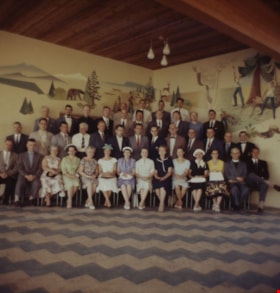
1958 Centennial Committee
https://search.heritageburnaby.ca/link/archivedescription55590
- Repository
- City of Burnaby Archives
- Date
- 1958
- Collection/Fonds
- John Shaw fonds
- Description Level
- Item
- Physical Description
- 1 photograph : col. slide (Munshaw) ; 7 x 7 cm
- Scope and Content
- Photograph of forty-one Burnaby Centennial Committee members at the Burnaby Centennial Pavilion on Burnaby Mountain. John Shaw, Municipal Clerk, can be seen in the second row from the front, 6th from the left and Reverend Faulkner is seated in the front row, second from the left. The rest are unide…
- Repository
- City of Burnaby Archives
- Date
- 1958
- Collection/Fonds
- John Shaw fonds
- Series
- Civil Service series
- Physical Description
- 1 photograph : col. slide (Munshaw) ; 7 x 7 cm
- Description Level
- Item
- Record No.
- 485-065
- Access Restriction
- No restrictions
- Reproduction Restriction
- Reproduce for fair dealing purposes only
- Accession Number
- 2005-15
- 2006-01
- 2007-18
- Scope and Content
- Photograph of forty-one Burnaby Centennial Committee members at the Burnaby Centennial Pavilion on Burnaby Mountain. John Shaw, Municipal Clerk, can be seen in the second row from the front, 6th from the left and Reverend Faulkner is seated in the front row, second from the left. The rest are unidentified.
- Media Type
- Photograph
- Notes
- Title based on contents of photograph
- Note on vero reads: "1958 Centennial Cmte. Burnaby Mtn"
- Geographic Access
- Burnaby Mountain Conservation Area
- Centennial Way
- Street Address
- 100 Centennial Way
- Planning Study Area
- Burnaby Mountain Area
Images

![2924 Silver Avenue, [1954] (date of original), copied 1991 thumbnail](/media/hpo/_Data/_Archives_Images/_Unrestricted/370/370-340.jpg?width=280)
2924 Silver Avenue
https://search.heritageburnaby.ca/link/archivedescription37752
- Repository
- City of Burnaby Archives
- Date
- [1954] (date of original), copied 1991
- Collection/Fonds
- Burnaby Historical Society fonds
- Description Level
- Item
- Physical Description
- 1 photograph : b&w ; 2.5 x 3.9 cm print on contact sheet 20.5 x 26.4 cm
- Scope and Content
- Photograph of the completed addition to 2924 Silver Avenue (later renumbered 6113 Silver Avenue).
- Repository
- City of Burnaby Archives
- Date
- [1954] (date of original), copied 1991
- Collection/Fonds
- Burnaby Historical Society fonds
- Subseries
- Burnaby Image Bank subseries
- Physical Description
- 1 photograph : b&w ; 2.5 x 3.9 cm print on contact sheet 20.5 x 26.4 cm
- Description Level
- Item
- Record No.
- 370-340
- Access Restriction
- No restrictions
- Reproduction Restriction
- No restrictions
- Accession Number
- BHS1999-03
- Scope and Content
- Photograph of the completed addition to 2924 Silver Avenue (later renumbered 6113 Silver Avenue).
- Subjects
- Buildings - Residential - Houses
- Media Type
- Photograph
- Notes
- Title based on contents of photograph
- 1 b&w copy negative accompanying
- Negative has a pink cast
- Geographic Access
- Silver Avenue
- Street Address
- 6113 Silver Avenue
- Historic Neighbourhood
- Central Park (Historic Neighbourhood)
- Planning Study Area
- Maywood Area
Images
![2924 Silver Avenue, [1954] (date of original), copied 1991 thumbnail](/media/hpo/_Data/_Archives_Images/_Unrestricted/370/370-340.jpg)

2924 Silver Avenue
https://search.heritageburnaby.ca/link/archivedescription37753
- Repository
- City of Burnaby Archives
- Date
- June 1954 (date of original), copied 1991
- Collection/Fonds
- Burnaby Historical Society fonds
- Description Level
- Item
- Physical Description
- 1 photograph : b&w ; 2.6 x 3.9 cm print on contact sheet 20.5 x 26.4 cm
- Scope and Content
- Photograph of the construction of an addition to 2924 Silver Avenue (later renumbered 6113 Silver Avenue). Three people are on the roof of the house, and two others are on a ladder.
- Repository
- City of Burnaby Archives
- Date
- June 1954 (date of original), copied 1991
- Collection/Fonds
- Burnaby Historical Society fonds
- Subseries
- Burnaby Image Bank subseries
- Physical Description
- 1 photograph : b&w ; 2.6 x 3.9 cm print on contact sheet 20.5 x 26.4 cm
- Description Level
- Item
- Record No.
- 370-341
- Access Restriction
- No restrictions
- Reproduction Restriction
- No restrictions
- Accession Number
- BHS1999-03
- Scope and Content
- Photograph of the construction of an addition to 2924 Silver Avenue (later renumbered 6113 Silver Avenue). Three people are on the roof of the house, and two others are on a ladder.
- Media Type
- Photograph
- Notes
- Title based on contents of photograph
- 1 b&w copy negative accompanying
- Negative has a pink cast
- Geographic Access
- Silver Avenue
- Street Address
- 6113 Silver Avenue
- Historic Neighbourhood
- Central Park (Historic Neighbourhood)
- Planning Study Area
- Maywood Area
Images

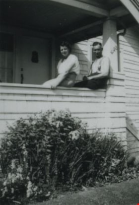
4123 Oxford Street
https://search.heritageburnaby.ca/link/archivedescription38197
- Repository
- City of Burnaby Archives
- Date
- 1953 (date of original), copied 1991
- Collection/Fonds
- Burnaby Historical Society fonds
- Description Level
- Item
- Physical Description
- 1 photograph : b&w ; 4.2 x 2.8 cm print on contact sheet 20.3 x 26.6 cm
- Scope and Content
- Photograph of a woman and a man sitting on the edge of the porch at 4123 Oxford Street.
- Repository
- City of Burnaby Archives
- Date
- 1953 (date of original), copied 1991
- Collection/Fonds
- Burnaby Historical Society fonds
- Subseries
- Burnaby Image Bank subseries
- Physical Description
- 1 photograph : b&w ; 4.2 x 2.8 cm print on contact sheet 20.3 x 26.6 cm
- Description Level
- Item
- Record No.
- 370-784
- Access Restriction
- No restrictions
- Reproduction Restriction
- No restrictions
- Accession Number
- BHS1999-03
- Scope and Content
- Photograph of a woman and a man sitting on the edge of the porch at 4123 Oxford Street.
- Media Type
- Photograph
- Notes
- Title based on contents of photograph
- 1 b&w copy negative accompanying
- Geographic Access
- Oxford Street
- Street Address
- 4123 Oxford Street
- Historic Neighbourhood
- Vancouver Heights (Historic Neighbourhood)
- Planning Study Area
- Burnaby Heights Area
Images


4297 Albert Street
https://search.heritageburnaby.ca/link/archivedescription37591
- Repository
- City of Burnaby Archives
- Date
- 1951 (date of original), copied 1991
- Collection/Fonds
- Burnaby Historical Society fonds
- Description Level
- Item
- Physical Description
- 1 photograph : b&w ; 2.7 x 4.2 cm print on contact sheet 20.2 x 25.3 cm
- Scope and Content
- Photograph of 4297 Albert Street. Another house is visible in the background.
- Repository
- City of Burnaby Archives
- Date
- 1951 (date of original), copied 1991
- Collection/Fonds
- Burnaby Historical Society fonds
- Subseries
- Burnaby Image Bank subseries
- Physical Description
- 1 photograph : b&w ; 2.7 x 4.2 cm print on contact sheet 20.2 x 25.3 cm
- Description Level
- Item
- Record No.
- 370-179
- Access Restriction
- No restrictions
- Reproduction Restriction
- No restrictions
- Accession Number
- BHS1999-03
- Scope and Content
- Photograph of 4297 Albert Street. Another house is visible in the background.
- Subjects
- Buildings - Residential - Houses
- Media Type
- Photograph
- Notes
- Title based on contents of photograph
- 1 b&w copy negative accompanying
- Negative has a pink cast
- Geographic Access
- Albert Street
- Street Address
- 4297 Albert Street
- Historic Neighbourhood
- Vancouver Heights (Historic Neighbourhood)
- Planning Study Area
- Burnaby Heights Area
Images


4297 Albert Street
https://search.heritageburnaby.ca/link/archivedescription37592
- Repository
- City of Burnaby Archives
- Date
- 1950 (date of original), copied 1991
- Collection/Fonds
- Burnaby Historical Society fonds
- Description Level
- Item
- Physical Description
- 1 photograph : b&w ; 3.4 x 3.5 cm print on contact sheet 20.2 x 25.3 cm
- Scope and Content
- Photograph of 4297 Albert Street.
- Repository
- City of Burnaby Archives
- Date
- 1950 (date of original), copied 1991
- Collection/Fonds
- Burnaby Historical Society fonds
- Subseries
- Burnaby Image Bank subseries
- Physical Description
- 1 photograph : b&w ; 3.4 x 3.5 cm print on contact sheet 20.2 x 25.3 cm
- Description Level
- Item
- Record No.
- 370-180
- Access Restriction
- No restrictions
- Reproduction Restriction
- No restrictions
- Accession Number
- BHS1999-03
- Scope and Content
- Photograph of 4297 Albert Street.
- Subjects
- Buildings - Residential - Houses
- Media Type
- Photograph
- Notes
- Title based on contents of photograph
- 1 b&w copy negative accompanying
- Negative has a pink cast
- Geographic Access
- Albert Street
- Street Address
- 4297 Albert Street
- Historic Neighbourhood
- Vancouver Heights (Historic Neighbourhood)
- Planning Study Area
- Burnaby Heights Area
Images

![4674 Southlawn Drive, [1958] (date of original), copied 1991 thumbnail](/media/hpo/_Data/_Archives_Images/_Unrestricted/370/370-461.jpg?width=280)
4674 Southlawn Drive
https://search.heritageburnaby.ca/link/archivedescription37873
- Repository
- City of Burnaby Archives
- Date
- [1958] (date of original), copied 1991
- Collection/Fonds
- Burnaby Historical Society fonds
- Description Level
- Item
- Physical Description
- 1 photograph : b&w ; 2.8 x 2.8 cm print on contact sheet 20.1 x 26.7 cm
- Scope and Content
- Photograph of 4674 Southlawn Drive in the snow. The snow-covered road can be seen in front of the house.
- Repository
- City of Burnaby Archives
- Date
- [1958] (date of original), copied 1991
- Collection/Fonds
- Burnaby Historical Society fonds
- Subseries
- Burnaby Image Bank subseries
- Physical Description
- 1 photograph : b&w ; 2.8 x 2.8 cm print on contact sheet 20.1 x 26.7 cm
- Description Level
- Item
- Record No.
- 370-461
- Access Restriction
- No restrictions
- Reproduction Restriction
- No restrictions
- Accession Number
- BHS1999-03
- Scope and Content
- Photograph of 4674 Southlawn Drive in the snow. The snow-covered road can be seen in front of the house.
- Media Type
- Photograph
- Notes
- Title based on contents of photograph
- 1 b&w copy negative accompanying
- Negative has a pink cast
- Geographic Access
- Southlawn Drive
- Street Address
- 4674 Southlawn Drive
- Planning Study Area
- Brentwood Area
Images
![4674 Southlawn Drive, [1958] (date of original), copied 1991 thumbnail](/media/hpo/_Data/_Archives_Images/_Unrestricted/370/370-461.jpg)
![4674 Southlawn Drive, [ca. 1954] (date of original), copied 1991 thumbnail](/media/hpo/_Data/_Archives_Images/_Unrestricted/370/370-462.jpg?width=280)
4674 Southlawn Drive
https://search.heritageburnaby.ca/link/archivedescription37874
- Repository
- City of Burnaby Archives
- Date
- [ca. 1954] (date of original), copied 1991
- Collection/Fonds
- Burnaby Historical Society fonds
- Description Level
- Item
- Physical Description
- 1 photograph : b&w ; 2.5 x 3.7 cm print on contact sheet 20.1 x 26.7 cm
- Scope and Content
- Photograph of the view from 4674 Southlawn Drive, facing north. A car and houses across the street can be seen. Capitol Hill is visible in the distance.
- Repository
- City of Burnaby Archives
- Date
- [ca. 1954] (date of original), copied 1991
- Collection/Fonds
- Burnaby Historical Society fonds
- Subseries
- Burnaby Image Bank subseries
- Physical Description
- 1 photograph : b&w ; 2.5 x 3.7 cm print on contact sheet 20.1 x 26.7 cm
- Description Level
- Item
- Record No.
- 370-462
- Access Restriction
- No restrictions
- Reproduction Restriction
- No restrictions
- Accession Number
- BHS1999-03
- Scope and Content
- Photograph of the view from 4674 Southlawn Drive, facing north. A car and houses across the street can be seen. Capitol Hill is visible in the distance.
- Media Type
- Photograph
- Notes
- Title based on contents of photograph
- 1 b&w copy negative accompanying
- Negative has a pink cast
- Geographic Access
- Southlawn Drive
- Planning Study Area
- Brentwood Area
Images
![4674 Southlawn Drive, [ca. 1954] (date of original), copied 1991 thumbnail](/media/hpo/_Data/_Archives_Images/_Unrestricted/370/370-462.jpg)
![4674 Southlawn Drive construction, [1954 or 1955] (date of original), copied 1991 thumbnail](/media/hpo/_Data/_Archives_Images/_Unrestricted/370/370-460.jpg?width=280)
4674 Southlawn Drive construction
https://search.heritageburnaby.ca/link/archivedescription37872
- Repository
- City of Burnaby Archives
- Date
- [1954 or 1955] (date of original), copied 1991
- Collection/Fonds
- Burnaby Historical Society fonds
- Description Level
- Item
- Physical Description
- 1 photograph : b&w ; 2.8 x 2.8 cm print on contact sheet 20.1 x 26.7 cm
- Scope and Content
- Photograph of the begining construction of a house at 4674 Southlawn Drive.
- Repository
- City of Burnaby Archives
- Date
- [1954 or 1955] (date of original), copied 1991
- Collection/Fonds
- Burnaby Historical Society fonds
- Subseries
- Burnaby Image Bank subseries
- Physical Description
- 1 photograph : b&w ; 2.8 x 2.8 cm print on contact sheet 20.1 x 26.7 cm
- Description Level
- Item
- Record No.
- 370-460
- Access Restriction
- No restrictions
- Reproduction Restriction
- No restrictions
- Accession Number
- BHS1999-03
- Scope and Content
- Photograph of the begining construction of a house at 4674 Southlawn Drive.
- Subjects
- Construction
- Media Type
- Photograph
- Notes
- Title based on contents of photograph
- 1 b&w copy negative accompanying
- Negative has a pink cast
- Geographic Access
- Southlawn Drive
- Street Address
- 4674 Southlawn Drive
- Planning Study Area
- Brentwood Area
Images
![4674 Southlawn Drive construction, [1954 or 1955] (date of original), copied 1991 thumbnail](/media/hpo/_Data/_Archives_Images/_Unrestricted/370/370-460.jpg)