Narrow Results By
Creator
- Alphonse J. Toebaert 1
- Anthony's of Kerrisdale 1
- Battistoni, Peter 16
- Binks, James 2
- Born, A. J. 3
- Bowman and Cullerne 1
- British Columbia Department of Education 1
- British Columbia Government Photograph 1
- British Columbia Underwriters' Association 10
- Bullen, Harry Elder 1
- Burnaby Village Museum 8
- Campbell, Peg 1

Interview with Alfred Bingham June 10, 1975 - Track 6
https://search.heritageburnaby.ca/link/oralhistory63
- Repository
- City of Burnaby Archives
- Date Range
- 1928-1929
- Length
- 0:09:46
- Summary
- This portion of the interview pertains to Alfred Bingham's employment just as the Depression hit. Alfred tells antecdotes, both amusing and disturbing, about working at a ranch out in Coquitlam.
- Repository
- City of Burnaby Archives
- Summary
- This portion of the interview pertains to Alfred Bingham's employment just as the Depression hit. Alfred tells antecdotes, both amusing and disturbing, about working at a ranch out in Coquitlam.
- Date Range
- 1928-1929
- Photo Info
- Alfred Bingham, April 20, 1947. Item no. 010-066
- Length
- 0:09:46
- Subjects
- Occupations
- Historic Neighbourhood
- British Columbia - Coquitlam
- Interviewer
- Bradbury, Dr. Bettina
- Interview Date
- June 10, 1975
- Scope and Content
- Recording is a taped interview with Alfred Bingham by SFU graduate student Bettina Bradbury June 10, 1975. Major themes discussed are: the Depression, Pioneers, and the Co-operative Movement. To view "Narrow By" terms for each track expand this description and see "Notes".
- Biographical Notes
- Alfred "Alf" Bingham was born in England in 1892 and moved to Canada in 1912. His first job in Canada was laying track for the Grand Trunk Pacific Railway (GTPR) from Edmonton to McBride in 1912. His second was in Vancouver at the Rat Portage Mill on False Creek, working on the Resaw machine. He quit after one week due to poor working conditions. After taking part in the 1919 Winnipeg General Strike as a delegate of the Retail and Mailorder Union (A.F.L.) on the Winnipeg Trades and Labour Council, Alfred moved to Burnaby where he and fellow Burnaby residents Angus McLean and Percy Little worked ten hour days to build a Shingle Mill on the edge of Burnaby Lake for Simpson & Giberson. George Green, carpenter and millwright (author of “The History of Burnaby”) also helped in the construction of the mill. Alfred built his own home from lumber cut from the mill in the Lochdale area on Sherlock Street between Curtis Street and Kitchener Street. On April 10, 1920 Alfred married Mary Jane “Ada” Reynolds. Alfred and Ada often took in foster children during their marriage. Due to her nursing experience, Ada was often called upon to deliver babies in the Burnaby area. Alfred and Ada Bingham were instrumental members of the Army of the Common Good, collecting vegetables and grains from growers in the area and even producing over 125 tons of vegetables from its own gardens to feed children and youth suffering from the lack of resources during the Depression years. The army was in operation for ten years and during that time the members organised the Credit Union movement of British Columbia and drew up the Credit Union act thorough the Vancouver Co-operative Council. They also started Co-Op stores and the Co-Op Wholesale Society. Alfred was also Secretary of the Burnaby Housing committee and in 1946 he became the Secretary of the North Burnaby Labour Progressive Party (LPP). Mary Jane “Ada” (Reynolds) Bingham died on August 9, 1969. Her husband Alfred died on April 29, 1979.
- Total Tracks
- 14
- Total Length
- 1:57:27
- Interviewee Name
- Bingham, Alfred "Alf"
- Interviewer Bio
- Bettina Bradbury teaches history and women's studies at York University. She is the author of Wife to Widow. Lives, Laws and Politics in Nineteenth-century Montreal. (Vancouver: University of British Columbia Press, June 2011), 520p; Working Families. Age, Gender and Daily Survival in Industrializing Montreal. (Toronto: Canadian Social History Series, McClelland and Stewart, 1993); (Republished Toronto: Oxford University Press, 1996) (3rd edition, Toronto: University of Toronto Press, 2007). These interviews were undertaken after she completed her MA at Simon Fraser University in 1975 with the support of an LIP grant.
- Collection/Fonds
- Burnaby Historical Society fonds
- Subseries
- Oral history subseries
- Media Type
- Sound Recording
- Web Notes
- Interview was digitized in 2010 allowing it to be accessible on Heritage Burnaby. The digitization project was initiated by the Community Heritage Commission with support from City of Burnaby Council and the BC History Digitization Program of the Irving K. Barber Learning Centre, University of British Columbia. It was recognized by the Heritage Society of BC with an award in 2012.
Images

Audio Tracks
Track six of interview with Alfred Bingham
Track six of interview with Alfred Bingham
https://search.heritageburnaby.ca/media/hpo/_Data/_Archives_Oral_Histories/_Unrestricted/100-13-20-1/100-13-20-1_Track_6.mp3![British Columbia Electric Railway Company timetables, [between 1946 and 1973] thumbnail](/media/hpo/_Data/_BVM_Images/1973/1973_0041_0005_001.jpg?width=280)
British Columbia Electric Railway Company timetables
https://search.heritageburnaby.ca/link/museumdescription996
- Repository
- Burnaby Village Museum
- Date
- [between 1946 and 1973]
- Collection/Fonds
- Burnaby Village Museum Photograph collection
- Description Level
- Item
- Physical Description
- 1 photograph : b&w ; 20.4 x 25.3 cm
- Scope and Content
- Photograph of a BC Electric Railway timetable for the Lulu Island Branch, Eburne, and New Westminster Line, including a Sunday schedule and freight schedule.
- Repository
- Burnaby Village Museum
- Collection/Fonds
- Burnaby Village Museum Photograph collection
- Description Level
- Item
- Physical Description
- 1 photograph : b&w ; 20.4 x 25.3 cm
- Scope and Content
- Photograph of a BC Electric Railway timetable for the Lulu Island Branch, Eburne, and New Westminster Line, including a Sunday schedule and freight schedule.
- Accession Code
- HV973.41.5
- Access Restriction
- No restrictions
- Reproduction Restriction
- May be restricted by third party rights
- Date
- [between 1946 and 1973]
- Media Type
- Photograph
- Related Material
- For an earlier donation made by the same donor in regards to BCER tram, see accession HV972.202.
- Scan Resolution
- 300
- Scan Date
- 2023-05-16
- Notes
- Title based on contents of photograph
Images
![British Columbia Electric Railway Company timetables, [between 1946 and 1973] thumbnail](/media/hpo/_Data/_BVM_Images/1973/1973_0041_0005_001.jpg)
![British Columbia Electric Railway Company timetables, [between 1946 and 1973] thumbnail](/media/hpo/_Data/_BVM_Images/1973/1973_0041_0006_001.jpg?width=280)
British Columbia Electric Railway Company timetables
https://search.heritageburnaby.ca/link/museumdescription997
- Repository
- Burnaby Village Museum
- Date
- [between 1946 and 1973]
- Collection/Fonds
- Burnaby Village Museum Photograph collection
- Description Level
- Item
- Physical Description
- 1 photograph : b&w ; 25.4 x 20.6 cm
- Scope and Content
- Photograph of two British Columbia Electric Railway Company timetables for the Central Park line, one "corrected to October 15, 1933" and the other "corrected to May 16, 1946." Also in the photograph are two tickets, one reads, "Good for one fare at 10 for $1.25 between Vancouver and Burnaby North…
- Repository
- Burnaby Village Museum
- Collection/Fonds
- Burnaby Village Museum Photograph collection
- Description Level
- Item
- Physical Description
- 1 photograph : b&w ; 25.4 x 20.6 cm
- Scope and Content
- Photograph of two British Columbia Electric Railway Company timetables for the Central Park line, one "corrected to October 15, 1933" and the other "corrected to May 16, 1946." Also in the photograph are two tickets, one reads, "Good for one fare at 10 for $1.25 between Vancouver and Burnaby Northwest Zone" and the other reads, "Good for one fare between Vancouver and Park Ave."
- Accession Code
- HV973.41.6
- Access Restriction
- No restrictions
- Reproduction Restriction
- May be restricted by third party rights
- Date
- [between 1946 and 1973]
- Media Type
- Photograph
- Related Material
- For an earlier donation made by the same donor in regards to BCER tram, see accession HV972.202.
- Scan Resolution
- 300
- Scan Date
- 2023-05-16
- Notes
- Title based on contents of photograph
Images
![British Columbia Electric Railway Company timetables, [between 1946 and 1973] thumbnail](/media/hpo/_Data/_BVM_Images/1973/1973_0041_0006_001.jpg)
![British Columbia School of Pharmacy and Science, [1920] thumbnail](/media/hpo/_Data/_BVM_Images/1985/198800680003.jpg?width=280)
British Columbia School of Pharmacy and Science
https://search.heritageburnaby.ca/link/museumdescription112
- Repository
- Burnaby Village Museum
- Date
- [1920]
- Collection/Fonds
- Burnaby Village Museum Photograph collection
- Description Level
- Item
- Physical Description
- 1 photograph : sepia composite ; 26.5 x 34 cm
- Scope and Content
- Composite photograph of students of the British Columbia School of Pharmacy and Science. Names are listed beneath each of the oval photographs (grouped in four rows). In the top row (from left) are; F. McIntosh "Mat. Med + Botany", O.P. Harrison, H.E. Falk, I.M. Wilson, E.G. McDonagh, G.H. Goodard,…
- Repository
- Burnaby Village Museum
- Collection/Fonds
- Burnaby Village Museum Photograph collection
- Description Level
- Item
- Physical Description
- 1 photograph : sepia composite ; 26.5 x 34 cm
- Scope and Content
- Composite photograph of students of the British Columbia School of Pharmacy and Science. Names are listed beneath each of the oval photographs (grouped in four rows). In the top row (from left) are; F. McIntosh "Mat. Med + Botany", O.P. Harrison, H.E. Falk, I.M. Wilson, E.G. McDonagh, G.H. Goodard, P.J. Bain "Principal". Second row; A. McLennan, C.C. Denny, W.G. Smith, L.P. Landry, E.J. Harrison, B.M. Adams, H.D. Hipwell, and A.W. Barr. Third row; H.L. Fee, C.D. Houghland, A.R. Bush, R.W. Smith, W. James, B.A. McKeown, W.K. Corning, S.R. Davies and G.W.H. Stearman. Bottom row; G. Baillie "Pharmacy + Physics", A.H. Blumenauer, D.J. Bailey, J.Q. Adams, G.P. Doran and S. Foulds "Chemistry".
- Subjects
- Occupations - Teachers
- Names
- British Columbia School of Pharmacy and Science
- McIntosh, F.
- Harrison, O. P.
- Falk, H. E.
- Wilson, I. M.
- McDonagh, E. G.
- Goodard, G. H.
- Bain, P. J.
- McLennan, A.
- Denny, C. C.
- Smith, W.G.
- Landry, L. P.
- Harrison, E. J.
- Adams, B. M.
- Hipwell, H. D.
- Barr, A.W.
- Fee, H. L.
- Houghland, C. D.
- Bush, A. R.
- Smith, R.W.
- James, W.
- McKeown, B. A.
- Corning, W. K.
- Davies, S. R.
- Stearman, G. W. H.
- Baillie, G.
- Blumenauer, A. H.
- Bailey, D. J.
- Adams, J. Q.
- Doran, G. P.
- Foulds, S.
- Henderson, Gibb Gilmour
- University of British Columbia
- Accession Code
- BV988.68.3
- Access Restriction
- No restrictions
- Reproduction Restriction
- No known restrictions
- Date
- [1920]
- Media Type
- Photograph
- Scan Resolution
- 600
- Scan Date
- 1/11/2010
- Scale
- 100
- Photographer
- Weeks, Arthur Benson
- Notes
- Title based on contents of photograph
- Continuation of title: "... - Second Term 1920"
Images
![British Columbia School of Pharmacy and Science, [1920] thumbnail](/media/hpo/_Data/_BVM_Images/1985/198800680003.jpg)
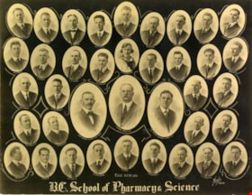
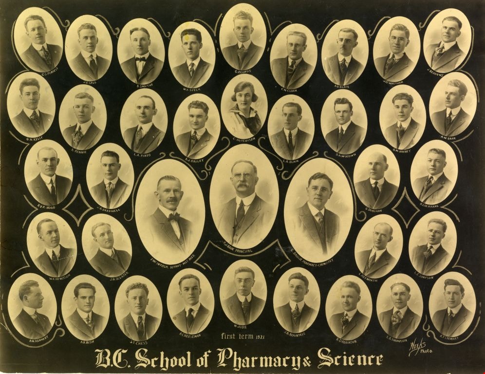
British Columbia School of Pharmacy and Science
https://search.heritageburnaby.ca/link/museumdescription113
- Repository
- Burnaby Village Museum
- Date
- 1921
- Collection/Fonds
- Burnaby Village Museum Photograph collection
- Description Level
- Item
- Physical Description
- 1 photograph : sepia composite ; 26.5 x 34 cm
- Scope and Content
- Composite photograph of students of the British Columbia School of Pharmacy and Science. Names are listed beneath each of the oval photographs (grouped in five rows). In the top row (from left) are; C.S. Forrest, J.G. Saul, S. Smythe, W.A. Speck, G.E. Curtis, C.N. Clark, A.O. Blain, J.D. Witham and…
- Repository
- Burnaby Village Museum
- Collection/Fonds
- Burnaby Village Museum Photograph collection
- Description Level
- Item
- Physical Description
- 1 photograph : sepia composite ; 26.5 x 34 cm
- Scope and Content
- Composite photograph of students of the British Columbia School of Pharmacy and Science. Names are listed beneath each of the oval photographs (grouped in five rows). In the top row (from left) are; C.S. Forrest, J.G. Saul, S. Smythe, W.A. Speck, G.E. Curtis, C.N. Clark, A.O. Blain, J.D. Witham and J. Beddows. In the second row are; G.H. Kelly, R. Rennie, L.A. Pineo, D.J. Bailey, C. Hutchinson, L.A. Blain, B.A. McKeown, G.M. Harvey and A.W. Barr. In the third row are; R.V.R. Hood, J. R. Bradwell, G. Donovan and R. Cochrane. In the centre (in larger ovals) are; F. McIntosh "Mat. Med + Botany", P. J. Bain "Principal" and G. Baillie "Pharmacy + Physics." In the fourth row are; W.R. Hewitson, J.H. Sclater, L. Heyworth and L.C. Simpson. In the bottom row are; A.W. Kennedy, A.R. Bush, S.T. Chess, A. Cheeseman, W. Jude, J.B. Rountree, H.D. Robinson, L.B. Thompson and K.T. Stewart.
- Subjects
- Occupations - Teachers
- Names
- British Columbia School of Pharmacy and Science
- Forrest, C.S.
- Saul, J.G.
- Smythe, S.
- Speck, W.A.
- Curtis, G.E.
- Clark, C.N.
- Blain, A.O.
- Witham, J.D.
- Beddows, J.
- Kelly, G.H.
- Rennie, R.
- Pineo, L.A..
- Bailey, D. J.
- Hutchinson, C.
- Blain, L.A.
- McKeown, B. A.
- Harvey, G.M.
- Barr, A.W.
- Hood, R.V.R.
- Bradwell, J.R.
- Donovan, G.
- Cochrane, R.
- McIntosh, F.
- Bain, P. J.
- Baillie, G.
- Hewitson, W.R.
- Sclater, J.H.
- Heyworth, L.
- Simpson, L.C.
- Kennedy, A.W.
- Bush, A. R.
- Chess, S.T.
- Cheeseman, A.
- Jude, W.
- Rountree, J.B.
- Robinson, H.D.
- Thompson, L.B.
- Stewart, K.T.
- Henderson, Gibb Gilmour
- University of British Columbia
- Accession Code
- BV988.68.4
- Access Restriction
- No restrictions
- Reproduction Restriction
- No known restrictions
- Date
- 1921
- Media Type
- Photograph
- Scan Resolution
- 600
- Scan Date
- 1/8/2010
- Scale
- 100
- Photographer
- Weeks, Arthur Benson
- Notes
- Continuation of title: "... first term 1921"
Images
British Columbia Spring Festival certificate
https://search.heritageburnaby.ca/link/museumdescription16731
- Repository
- Burnaby Village Museum
- Date
- 1975
- Collection/Fonds
- Century Park Museum Association fonds
- Description Level
- Item
- Physical Description
- 1p.
- Scope and Content
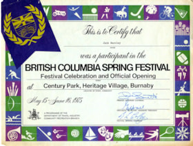
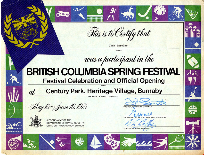
- Items consists of a certificate awarded to Jack Barclay as a participant in the British Columbia Spring Festival, Festival Celebration and Official Opening at Century Park, Heritage Village, Burnaby. The certificate is dated May 15-June 16, 1975 and is signed by Premier Honary Chairman, Dave Barret…
- Repository
- Burnaby Village Museum
- Collection/Fonds
- Century Park Museum Association fonds
- Description Level
- Item
- Physical Description
- 1p.
- Scope and Content
- Items consists of a certificate awarded to Jack Barclay as a participant in the British Columbia Spring Festival, Festival Celebration and Official Opening at Century Park, Heritage Village, Burnaby. The certificate is dated May 15-June 16, 1975 and is signed by Premier Honary Chairman, Dave Barrett; Provincial Secretary, Honorary President, G. Hall [sic]; Festival General Chairman, B.L. Colby.
- Subjects
- Documentary Artifacts - Certificates
- Accession Code
- BV020.5.1802
- Access Restriction
- No restrictions
- Reproduction Restriction
- No known restrictions
- Date
- 1975
- Media Type
- Textual Record
- Scan Resolution
- 600
- Scan Date
- June 18, 2021
- Scale
- 100
- Notes
- Title based on contents of item
Images
![Image of British Columbia Music Festival Certificate, [1926] (date of original), copied [2016] thumbnail](/media/hpo/_Data/_BVM_Images/2016/201600430009_001.jpg?width=280)
Image of British Columbia Music Festival Certificate
https://search.heritageburnaby.ca/link/museumdescription4108
- Repository
- Burnaby Village Museum
- Date
- [1926] (date of original), copied [2016]
- Collection/Fonds
- Esther Love Stanley fonds
- Description Level
- Item
- Physical Description
- 1 photograph (tiff)
- Scope and Content
- Copy scan of a certificate from the British Columbia Musical Festival. "This is to Certify that The Vancouver Scottish Orchestra / (Conductor, Thomas Shankie) / has been awarded First place in the competition for / Orchestras - Open - Holding the 'Gold Range' Challenge / Cup for 1926 / in the Briti…
- Repository
- Burnaby Village Museum
- Collection/Fonds
- Esther Love Stanley fonds
- Description Level
- Item
- Physical Description
- 1 photograph (tiff)
- Scope and Content
- Copy scan of a certificate from the British Columbia Musical Festival. "This is to Certify that The Vancouver Scottish Orchestra / (Conductor, Thomas Shankie) / has been awarded First place in the competition for / Orchestras - Open - Holding the 'Gold Range' Challenge / Cup for 1926 / in the British Columbia Musical Competition Festival, 1926."
- Subjects
- Documentary Artifacts - Certificates
- Accession Code
- BV016.43.9
- Access Restriction
- No restrictions
- Reproduction Restriction
- May be restricted by third party rights
- Date
- [1926] (date of original), copied [2016]
- Media Type
- Photograph
- Notes
- Title based on contents of photograph.
- Image is from a binder of family history. Binder 1, orange cover "Old Stanley Family Photo / Old Shankie Family Photos / War Photos - Echo Photos".
- Digital image created from orginal photograph by donor
Images
![Image of British Columbia Music Festival Certificate, [1926] (date of original), copied [2016] thumbnail](/media/hpo/_Data/_BVM_Images/2016/201600430009_001.jpg)
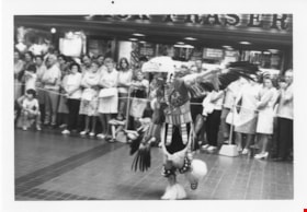
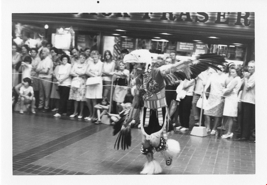
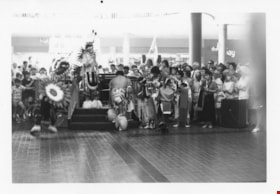
Indigenous dancer at Brentwood mall
https://search.heritageburnaby.ca/link/museumdescription13235
- Repository
- Burnaby Village Museum
- Date
- 1971
- Collection/Fonds
- Donald Copan collection
- Description Level
- Item
- Physical Description
- 1 photograph : b&w ; 8.9 x 12.7 cm
- Scope and Content
- Photograph of an Indigenous person in traditional clothing and dancing inside Brentwood Mall. A large group of people have gathered around to watch.
- Repository
- Burnaby Village Museum
- Collection/Fonds
- Donald Copan collection
- Series
- Copan album series
- Description Level
- Item
- Physical Description
- 1 photograph : b&w ; 8.9 x 12.7 cm
- Scope and Content
- Photograph of an Indigenous person in traditional clothing and dancing inside Brentwood Mall. A large group of people have gathered around to watch.
- Subjects
- Indigenous peoples - British Columbia
- Indigenous peoples - British Columbia - Rites and ceremonies
- Indigenous peoples - Clothing
- Buildings - Commercial - Malls
- Geographic Access
- Lougheed Highway
- Street Address
- 4567 Lougheed Highway
- Accession Code
- BV005.54.246
- Access Restriction
- Restricted access
- Reproduction Restriction
- May be restricted by third party rights
- Date
- 1971
- Media Type
- Photograph
- Planning Study Area
- Brentwood Area
- Scan Resolution
- 600
- Scan Date
- July 23, 2020
- Scale
- 100
- Notes
- Title based on contents of photograph
Images

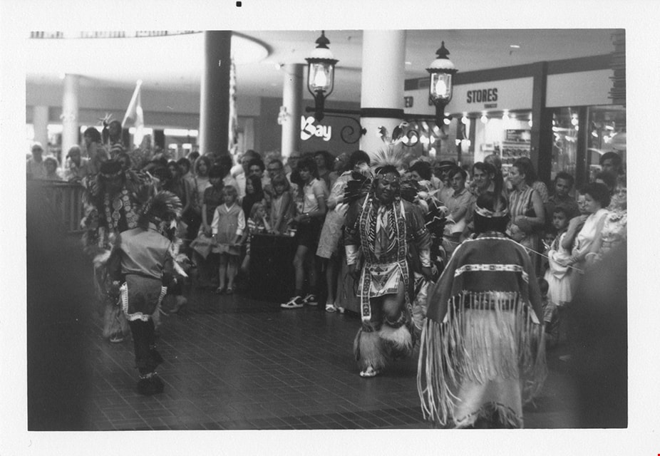
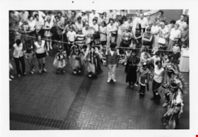
Indigenous dancers at Brentwood mall
https://search.heritageburnaby.ca/link/museumdescription2195
- Repository
- Burnaby Village Museum
- Date
- 1971
- Collection/Fonds
- Donald Copan collection
- Description Level
- Item
- Physical Description
- 1 photograph : b&w ; 8.9 x 12.7 cm
- Scope and Content
- Photograph of Indigenous peoples dressed in traditional clothing and dancing inside Brentwood Mall. A large group of people have gathered around to watch.
- Repository
- Burnaby Village Museum
- Collection/Fonds
- Donald Copan collection
- Series
- Copan album series
- Description Level
- Item
- Physical Description
- 1 photograph : b&w ; 8.9 x 12.7 cm
- Scope and Content
- Photograph of Indigenous peoples dressed in traditional clothing and dancing inside Brentwood Mall. A large group of people have gathered around to watch.
- Subjects
- Indigenous peoples - British Columbia
- Indigenous peoples - British Columbia - Rites and ceremonies
- Indigenous peoples - Clothing
- Buildings - Commercial - Malls
- Geographic Access
- Lougheed Highway
- Street Address
- 4567 Lougheed Highway
- Accession Code
- BV005.54.243
- Access Restriction
- No restrictions
- Reproduction Restriction
- May be restricted by third party rights
- Date
- 1971
- Media Type
- Photograph
- Planning Study Area
- Brentwood Area
- Scan Resolution
- 600
- Scan Date
- July 23, 2020
- Scale
- 100
- Notes
- Title based on contents of photograph
Images
Indigenous dancers at Brentwood mall
https://search.heritageburnaby.ca/link/museumdescription13233
- Repository
- Burnaby Village Museum
- Date
- 1971
- Collection/Fonds
- Donald Copan collection
- Description Level
- Item
- Physical Description
- 1 photograph : b&w ; 8.9 x 12.7 cm
- Scope and Content
- Photograph of Indigenous peoples dressed in traditional clothing and dancing inside Brentwood Mall. A large group of people have gathered around to watch.
- Repository
- Burnaby Village Museum
- Collection/Fonds
- Donald Copan collection
- Series
- Copan album series
- Description Level
- Item
- Physical Description
- 1 photograph : b&w ; 8.9 x 12.7 cm
- Scope and Content
- Photograph of Indigenous peoples dressed in traditional clothing and dancing inside Brentwood Mall. A large group of people have gathered around to watch.
- Subjects
- Indigenous peoples - British Columbia
- Indigenous peoples - British Columbia - Rites and ceremonies
- Indigenous peoples - Clothing
- Buildings - Commercial - Malls
- Geographic Access
- Lougheed Highway
- Street Address
- 4567 Lougheed Highway
- Accession Code
- BV005.54.244
- Access Restriction
- Restricted access
- Reproduction Restriction
- May be restricted by third party rights
- Date
- 1971
- Media Type
- Photograph
- Planning Study Area
- Brentwood Area
- Scan Resolution
- 600
- Scan Date
- July 23, 2020
- Scale
- 100
- Notes
- Title based on contents of photograph
Images

Indigenous dancers at Brentwood mall
https://search.heritageburnaby.ca/link/museumdescription13234
- Repository
- Burnaby Village Museum
- Date
- 1971
- Collection/Fonds
- Donald Copan collection
- Description Level
- Item
- Physical Description
- 1 photograph : b&w ; 8.9 x 12.7 cm
- Scope and Content
- Photograph of Indigenous peoples dressed in traditional clothing and dancing inside Brentwood Mall. A large group of people have gathered around to watch.
- Repository
- Burnaby Village Museum
- Collection/Fonds
- Donald Copan collection
- Series
- Copan album series
- Description Level
- Item
- Physical Description
- 1 photograph : b&w ; 8.9 x 12.7 cm
- Scope and Content
- Photograph of Indigenous peoples dressed in traditional clothing and dancing inside Brentwood Mall. A large group of people have gathered around to watch.
- Subjects
- Indigenous peoples - British Columbia
- Indigenous peoples - British Columbia - Rites and ceremonies
- Indigenous peoples - Clothing
- Buildings - Commercial - Malls
- Geographic Access
- Lougheed Highway
- Street Address
- 4567 Lougheed Highway
- Accession Code
- BV005.54.245
- Access Restriction
- Restricted access
- Reproduction Restriction
- May be restricted by third party rights
- Date
- 1971
- Media Type
- Photograph
- Planning Study Area
- Brentwood Area
- Scan Resolution
- 600
- Scan Date
- July 23, 2020
- Scale
- 100
- Notes
- Title based on contents of photograph
Images

Indigenous dancers at Brentwood mall
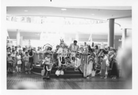
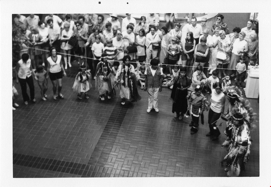
https://search.heritageburnaby.ca/link/museumdescription13236
- Repository
- Burnaby Village Museum
- Date
- 1971
- Collection/Fonds
- Donald Copan collection
- Description Level
- Item
- Physical Description
- 1 photograph : b&w ; 8.9 x 12.7 cm
- Scope and Content
- Photograph of an Indigenous peoples gathered in a circle with non-indigenous people inside Brentwood Mall. Indigenous peoples are dressed in traditional clothing. A large group of people have gathered around to watch.
- Repository
- Burnaby Village Museum
- Collection/Fonds
- Donald Copan collection
- Series
- Copan album series
- Description Level
- Item
- Physical Description
- 1 photograph : b&w ; 8.9 x 12.7 cm
- Scope and Content
- Photograph of an Indigenous peoples gathered in a circle with non-indigenous people inside Brentwood Mall. Indigenous peoples are dressed in traditional clothing. A large group of people have gathered around to watch.
- Subjects
- Indigenous peoples - British Columbia
- Indigenous peoples - British Columbia - Rites and ceremonies
- Indigenous peoples - Clothing
- Buildings - Commercial - Malls
- Geographic Access
- Lougheed Highway
- Street Address
- 4567 Lougheed Highway
- Accession Code
- BV005.54.247
- Access Restriction
- Restricted access
- Reproduction Restriction
- May be restricted by third party rights
- Date
- 1971
- Media Type
- Photograph
- Planning Study Area
- Brentwood Area
- Scan Resolution
- 600
- Scan Date
- July 23, 2020
- Scale
- 100
- Notes
- Title based on contents of photograph
Images

Municipality of Burnaby - Volume XV and Volume XVIII
https://search.heritageburnaby.ca/link/museumdescription8680
- Repository
- Burnaby Village Museum
- Date
- May 1927
- Collection/Fonds
- Burnaby Village Museum Map collection
- Description Level
- File
- Physical Description
- 4 plans on 4 sheets : col. lithographic prints ; 63.5 x 53.5 cm folded to 53 x 31.5 cm
- Scope and Content
- File consists of four pages of plans removed from a bound book containing a series of fire insurance plans of the Municipality of Burnaby. The first two pages are numbered "A" and "B" and are key plans from "GREATER VANCOUVER B.C. / VOLUME XV / Surveyed _ May 1927 / MUNICIPALITY OF / BURNABY", "PLA…
- Repository
- Burnaby Village Museum
- Collection/Fonds
- Burnaby Village Museum Map collection
- Description Level
- File
- Physical Description
- 4 plans on 4 sheets : col. lithographic prints ; 63.5 x 53.5 cm folded to 53 x 31.5 cm
- Material Details
- Scales [1:1200] and [1:6000]
- Scope and Content
- File consists of four pages of plans removed from a bound book containing a series of fire insurance plans of the Municipality of Burnaby. The first two pages are numbered "A" and "B" and are key plans from "GREATER VANCOUVER B.C. / VOLUME XV / Surveyed _ May 1927 / MUNICIPALITY OF / BURNABY", "PLAN DEPT. FIRE BRANCH _ B.C. INSURANCE UNDERWRITERS ASSN.". Key Plan "B" covers plans: 1505; 1506; 1512 to 1516; 1540 to 1544; 1550 to 1557 and District Lots: 129 to 132; 135 to 138; 205 to 208 and 215 to 218. Key Plan "A" covers plans: 1501 to 1504; 1507 to 1511; 1517 to 1525; 1531 to 1539; 1545 to 1550 and District Lots: 116 to 127 and 186 to 189. Plan "1806" is part of "GREATER VANCOUVER B.C. / VOLUME XVIII / Municipality of Burnaby / May, 1927" and covers District Lot 153. Plan "1807" is from "GREATER VANCOUVER B.C. / VOLUME XVIII / Municipality of Burnaby / May, 1927" and covers District Lots: 99,149 and 152.
- Responsibility
- British Columbia Underwriters' Association
- Accession Code
- HV972.111.2
- Access Restriction
- No restrictions
- Reproduction Restriction
- May be restricted by third party rights
- Date
- May 1927
- Media Type
- Cartographic Material
- Historic Neighbourhood
- Vancouver Heights (Historic Neighbourhood)
- Lochdale (Historic Neighbourhood)
- Capitol Hill (Historic Neighbourhood)
- Central Park (Historic Neighbourhood)
- Alta Vista (Historic Neighbourhood)
- Planning Study Area
- Burnaby Heights Area
- Sperling-Broadway Area
- Lochdale Area
- Parkcrest-Aubrey Area
- Westridge Area
- Willingdon Heights Area
- Capitol Hill Area
- Maywood Area
- Marlborough Area
- Scan Resolution
- 400
- Scan Date
- 2021-11-18
- Notes
- Title based on content of plans
- Scales are measured 1 inch = 100 feet and 1 inch = 500 feet
- See also BV987.1.70d for revised versions of plans
Zoomable Images


Municipality of Burnaby - Volume XV and Volume XVIII
https://search.heritageburnaby.ca/link/museumdescription8681
- Repository
- Burnaby Village Museum
- Date
- May 1927
- Collection/Fonds
- Burnaby Village Museum Map collection
- Description Level
- File
- Physical Description
- 4 plans on 4 sheets : col. lithographic prints, ms. annotations in blue ink ; 63.5 x 53.5 cm folded to 53 x 31.5 cm
- Scope and Content
- File consists of four pages of plans removed from a bound book containing a series of fire insurance plans of the Municipality of Burnaby. Plan "1507" and plan "1517" are from "GREATER VANCOUVER B.C. / VOLUME XV / Municipality of Burnaby / May, 1927". Plan "1507" covers District Lot 186 and plan "1…
- Repository
- Burnaby Village Museum
- Collection/Fonds
- Burnaby Village Museum Map collection
- Description Level
- File
- Physical Description
- 4 plans on 4 sheets : col. lithographic prints, ms. annotations in blue ink ; 63.5 x 53.5 cm folded to 53 x 31.5 cm
- Material Details
- Scale [1:600] and [1:1200]
- Scope and Content
- File consists of four pages of plans removed from a bound book containing a series of fire insurance plans of the Municipality of Burnaby. Plan "1507" and plan "1517" are from "GREATER VANCOUVER B.C. / VOLUME XV / Municipality of Burnaby / May, 1927". Plan "1507" covers District Lot 186 and plan "1517" covers District Lot 116. Plan "1804" and plan "1805" are from "GREATER VANCOUVER B.C. / VOLUME XVIII / Municipality of Burnaby / May, 1927". Plans "1804" and "1805" cover District Lot 153.
- Responsibility
- British Columbia Underwriters' Association
- Accession Code
- HV972.111.3
- Access Restriction
- No restrictions
- Reproduction Restriction
- May be restricted by third party rights
- Date
- May 1927
- Media Type
- Cartographic Material
- Historic Neighbourhood
- Central Park (Historic Neighbourhood)
- Vancouver Heights (Historic Neighbourhood)
- Planning Study Area
- Maywood Area
- Willingdon Heights Area
- Scan Resolution
- 400
- Scan Date
- 2021-11-18
- Notes
- Title based on content of plans
- See also BV987.1.70d for revised versions of plans
- Scale is measured 1 inch = 100 feet
Images


![Municipality of Burnaby - Volume XV and Volume XVIII, 1927-[1940] thumbnail](/media/hpo/_Data/_BVM_Artifacts/1972/1972_0111_0004_003.jpg?width=280)
Municipality of Burnaby - Volume XV and Volume XVIII
https://search.heritageburnaby.ca/link/museumdescription8682
- Repository
- Burnaby Village Museum
- Date
- 1927-[1940]
- Collection/Fonds
- Burnaby Village Museum Map collection
- Description Level
- File
- Physical Description
- 4 plans on 4 sheets: col. lithographic prints ; 63.5 x 53.5 cm folded to 53 x 31.5 cm
- Scope and Content
- File consists of four pages of plans removed from a bound book containing a series of fire insurance plans of the Municipality of Burnaby. Plan "1518" and "1519" are from "GREATER VANCOUVER B.C. / VOLUME XV / Municipality of Burnaby / May, 1927". Plan "1518" covers District Lot 116 and Plan "1519"…
- Repository
- Burnaby Village Museum
- Collection/Fonds
- Burnaby Village Museum Map collection
- Description Level
- File
- Physical Description
- 4 plans on 4 sheets: col. lithographic prints ; 63.5 x 53.5 cm folded to 53 x 31.5 cm
- Material Details
- Scale [1:600]
- Scope and Content
- File consists of four pages of plans removed from a bound book containing a series of fire insurance plans of the Municipality of Burnaby. Plan "1518" and "1519" are from "GREATER VANCOUVER B.C. / VOLUME XV / Municipality of Burnaby / May, 1927". Plan "1518" covers District Lot 116 and Plan "1519" covers District Lot 121. Plan "1802" and plan "1803" are from "GREATER VANCOUVER B.C. / VOLUME XVIII / Municipality of Burnaby / May, 1927". Both plans "1802" and "1803" cover District Lot 153.
- Responsibility
- British Columbia Underwriters' Association
- Accession Code
- HV972.111.4
- Access Restriction
- No restrictions
- Reproduction Restriction
- May be restricted by third party rights
- Date
- 1927-[1940]
- Media Type
- Cartographic Material
- Historic Neighbourhood
- Vancouver Heights (Historic Neighbourhood)
- Central Park (Historic Neighbourhood)
- Planning Study Area
- Willingdon Heights Area
- Marlborough Area
- Scan Resolution
- 400
- Scan Date
- 2021-11-18
- Notes
- Title based on content of plans
- See also BV987.1.70d for revised versions of plans
- Scale is measured 1 inch = 50 feet
- Contact Burnaby Village Museum to access plans 1518 and 1519 (these plans have revisions on top - date of revisions is uncertain)
Images
![Municipality of Burnaby - Volume XV and Volume XVIII, 1927-[1940] thumbnail](/media/hpo/_Data/_BVM_Artifacts/1972/1972_0111_0004_003.jpg)


Municipality of Burnaby- Volume XV and Volume XVIII
https://search.heritageburnaby.ca/link/museumdescription8686
- Repository
- Burnaby Village Museum
- Date
- May 1927
- Collection/Fonds
- Burnaby Village Museum Map collection
- Description Level
- File
- Physical Description
- 4 plans on 4 sheets : col. lithographic prints ; 63.5 x 53.5 cm folded to 53 x 31.5 cm
- Scope and Content
- File consists of four pages of plans removed from a bound book containing a series of fire insurance plans of the Municipality of Burnaby. Plan "1520" is part of "GREATER VANCOUVER B.C. / VOLUME XV / Municipality of Burnaby / May 1927" and covers District Lots: 121 and 187. Plann "1521" is part of …
- Repository
- Burnaby Village Museum
- Collection/Fonds
- Burnaby Village Museum Map collection
- Description Level
- File
- Physical Description
- 4 plans on 4 sheets : col. lithographic prints ; 63.5 x 53.5 cm folded to 53 x 31.5 cm
- Material Details
- Scale [1:600] and [1:1200]
- Scope and Content
- File consists of four pages of plans removed from a bound book containing a series of fire insurance plans of the Municipality of Burnaby. Plan "1520" is part of "GREATER VANCOUVER B.C. / VOLUME XV / Municipality of Burnaby / May 1927" and covers District Lots: 121 and 187. Plann "1521" is part of "GREATER VANCOUVER B.C. / VOLUME XV / Municipality of Burnaby / May 1927" and covers District Lots: 121 and 187. Key plan "H" reads: "GREATER VANCOUVER B.C. / VOLUME XVIII / Surveyed _ May 1927 / MUNICIPALITY OF / BURNABY" and covers plans: 1813 to 1822; 1824 to 1832; 1839; 1840; 1853 to 1865 and District Lots: 28; 30; 53; 90 to 93; 95 to 97; 155a; 155b; 155c; 159; 160; 171 to 173. Plan "1801" is part of "GREATER VANCOUVER B.C. / VOLUME XVIII / Municipality of Burnaby / May 1927" and covers District Lot 153.
- Responsibility
- British Columbia Underwriters' Association
- Accession Code
- HV972.111.8
- Access Restriction
- No restrictions
- Reproduction Restriction
- May be restricted by third party rights
- Date
- May 1927
- Media Type
- Cartographic Material
- Historic Neighbourhood
- Fraser Arm (Historic Neighbourhood)
- Vancouver Heights (Historic Neighbourhood)
- East Burnaby (Historic Neighbourhood)
- Edmonds (Historic Neighbourhood)
- Planning Study Area
- Marlborough Area
- Kingsway-Beresford Area
- Windsor Area
- Big Bend Area
- Clinton-Glenwood Area
- Burnaby Heights Area
- Edmonds Area
- Stride Avenue Area
- Scan Resolution
- 400
- Scan Date
- 2021-11-18
- Notes
- Title based on content of plans
- See also BV987.1.70d for revised versions of plans
- Scale is measured 1 inch = 500 feet
Zoomable Images


Municipality of Burnaby - Volume XVI and Volume XVII
https://search.heritageburnaby.ca/link/museumdescription8684
- Repository
- Burnaby Village Museum
- Date
- May 1927
- Collection/Fonds
- Burnaby Village Museum Map collection
- Description Level
- File
- Physical Description
- 4 plans on 4 sheets : col. lithographic prints ; 63.5 x 53.5 cm folded to 53 x 31.5 cm
- Scope and Content
- File consists of four pages of plans removed from a bound book containing a series of fire insurance plans of the Municipality of Burnaby. Page "D" is titled: "GREATER VANCOUVER B.C. / VOLUME XVI / Surveyed _ May 1927 / MUNICIPALITY OF / BURNABY / PLAN DEPT. FIRE BRANCH _ B.C. INSURANCE UNDERWRITE…
- Repository
- Burnaby Village Museum
- Collection/Fonds
- Burnaby Village Museum Map collection
- Description Level
- File
- Physical Description
- 4 plans on 4 sheets : col. lithographic prints ; 63.5 x 53.5 cm folded to 53 x 31.5 cm
- Material Details
- Scale [1:1200] and [1:6000]
- Scope and Content
- File consists of four pages of plans removed from a bound book containing a series of fire insurance plans of the Municipality of Burnaby. Page "D" is titled: "GREATER VANCOUVER B.C. / VOLUME XVI / Surveyed _ May 1927 / MUNICIPALITY OF / BURNABY / PLAN DEPT. FIRE BRANCH _ B.C. INSURANCE UNDERWRITERS ASSN." / KEY PLAN". Plans covered in this "Key Plan" are numbered 1601 to 1626, 1632 and 1651 covering District Lots: 15; 31; 100 to 102; 114; 141 to 144; 147 and 148; 209 to 214. Plan "E" is part of "GREATER VANCOUVER B.C. / VOLUME XVII / Municipality of Burnaby / May 1927" and covers plans: 1701 to 1705; 1711 to 1715; 1723 to 1727; 1729 to 1733; 1737 to 1742 and District Lots: 68 to 74; 80 to 84; 32 to 35 and 38 to 39. Plan marked "F" is a key plan titled: "GREATER VANCOUVER B.C. / VOLUME XVII / Surveyed _ May 1927 / MUNICIPALITY OF / BURNABY and covers plans: 1706 to 1710; 1716 to 1722; 1734 and 1735; 1743 to 1752 and District Lots: 42 to 44; 59; 75 to 80; 83 to 87; 89 to 93 and 130. Plan "1729" is part of "GREATER VANCOUVER B.C. / VOLUME XVII / Municipality of Burnaby / May 1927" and covers District Lots 34 and 35.
- Responsibility
- British Columbia Underwriters' Association
- Accession Code
- HV972.111.6
- Access Restriction
- No restrictions
- Reproduction Restriction
- May be restricted by third party rights
- Date
- May 1927
- Media Type
- Cartographic Material
- Historic Neighbourhood
- Barnet (Historic Neighbourhood)
- Burquitlam (Historic Neighbourhood)
- Central Park (Historic Neighbourhood)
- Burnaby Lake (Historic Neighbourhood)
- Broadview (Historic Neighbourhood)
- Planning Study Area
- Burnaby Mountain Area
- Lyndhurst Area
- Lake City Area
- Cascade-Schou Area
- Garden Village Area
- Douglas-Gilpin Area
- Oakalla Area
- Scan Resolution
- 400
- Scan Date
- 2021-11-18
- Notes
- Title based on content of plans
- See also BV987.1.70d for revised versions of plans
- Scale is measured 1 inch = 500 feet
Zoomable Images


Municipality of Burnaby - Volume XVIII
https://search.heritageburnaby.ca/link/museumdescription8687
- Repository
- Burnaby Village Museum
- Date
- May 1927
- Collection/Fonds
- Burnaby Village Museum Map collection
- Description Level
- File
- Physical Description
- 2 plans on 2 sheets : col. lithographic prints; 63.5 x 53.5 cm folded to 53 x 31.5 cm
- Scope and Content
- File consists of two pages of plans removed from a bound book containing a series of fire insurance plans of the Municipality of Burnaby. Plan "1819" and Plan "1820 are part of "GREATER VANCOUVER B.C. / VOLUME XVIII / Municipality of Burnaby / May 1927. Plan "1819" covers District Lot 95 and plan …
- Repository
- Burnaby Village Museum
- Collection/Fonds
- Burnaby Village Museum Map collection
- Description Level
- File
- Physical Description
- 2 plans on 2 sheets : col. lithographic prints; 63.5 x 53.5 cm folded to 53 x 31.5 cm
- Material Details
- Scales [1:600]
- Scope and Content
- File consists of two pages of plans removed from a bound book containing a series of fire insurance plans of the Municipality of Burnaby. Plan "1819" and Plan "1820 are part of "GREATER VANCOUVER B.C. / VOLUME XVIII / Municipality of Burnaby / May 1927. Plan "1819" covers District Lot 95 and plan "1820" covers District Lots 30 and 95.
- Responsibility
- British Columbia Underwriters' Association
- Accession Code
- HV972.111.38
- Access Restriction
- No restrictions
- Reproduction Restriction
- May be restricted by third party rights
- Date
- May 1927
- Media Type
- Cartographic Material
- Historic Neighbourhood
- Edmonds (Historic Neighbourhood)
- Highland Park (Historic Neighbourhood)
- Planning Study Area
- Stride Hill Area
- Kingsway-Beresford Area
- Scan Resolution
- 400
- Scan Date
- 2021-11-18
- Notes
- Title based on content of plans
- Scales are measured 1 inch = 50 feet
- See also BV987.1.70d for revised versions of plans
Images


Municipality of Burnaby - Volume XVIII and Volume XIX
https://search.heritageburnaby.ca/link/museumdescription8683
- Repository
- Burnaby Village Museum
- Date
- May 1927
- Collection/Fonds
- Burnaby Village Museum Map collection
- Description Level
- File
- Physical Description
- 2 plans on 2 sheets : col. lithographic prints ; 63.5 x 53.5 cm folded to 53 x 31.5 cm
- Scope and Content
- File consists of two pages of plans removed from a bound book containing a series of fire insurance plans of the Municipality of Burnaby. Plan "1832" is from "GREATER VANCOUVER B.C. / VOLUME XVIII / Municipality of Burnaby / May, 1927" and covers District Lots: 98 and 28. Plan "K" is part of a key …
- Repository
- Burnaby Village Museum
- Collection/Fonds
- Burnaby Village Museum Map collection
- Description Level
- File
- Physical Description
- 2 plans on 2 sheets : col. lithographic prints ; 63.5 x 53.5 cm folded to 53 x 31.5 cm
- Material Details
- Scale [1:1200] to [1:6000]
- Scope and Content
- File consists of two pages of plans removed from a bound book containing a series of fire insurance plans of the Municipality of Burnaby. Plan "1832" is from "GREATER VANCOUVER B.C. / VOLUME XVIII / Municipality of Burnaby / May, 1927" and covers District Lots: 98 and 28. Plan "K" is part of a key plan "GREATER VANCOUVER B.C. / Surveyed VOLUME XIX May 1927 / MUNICIPALITY OF / BURNABY / PLAN DEPT. British Columbia Ins. Underwriters Association / FIRE BRANCH / KEY PLAN", "Scale 500 FT = 1 INCH / FOR REPORT SEE VOL. XV" covering plans: 1901 to 1914 and District Lots: 161; 164 to 167; 155c; 155; 172 and 173.
- Responsibility
- British Columbia Underwriters' Association
- Accession Code
- HV972.111.5
- Access Restriction
- No restrictions
- Reproduction Restriction
- May be restricted by third party rights
- Date
- May 1927
- Media Type
- Cartographic Material
- Historic Neighbourhood
- East Burnaby (Historic Neighbourhood)
- Central Park (Historic Neighbourhood)
- Fraser Arm (Historic Neighbourhood)
- Alta Vista (Historic Neighbourhood)
- Planning Study Area
- Windsor Area
- Marlborough Area
- Second Street Area
- Big Bend Area
- Sussex-Nelson Area
- Scan Resolution
- 400
- Scan Date
- 2021-11-18
- Notes
- Title based on content of plans
- See also BV987.1.70d for revised versions of plans
- Scale is measured 1 inch = 500 feet
Zoomable Images


Municipality of Burnaby - Volume XV, Volume XVI, Volume XVII, Volume XVIII
https://search.heritageburnaby.ca/link/museumdescription8685
- Repository
- Burnaby Village Museum
- Date
- May 1927
- Collection/Fonds
- Burnaby Village Museum Map collection
- Description Level
- File
- Physical Description
- 4 plans on 4 sheets : col. lithographic prints ; 63.5 x 53.5 cm folded to 53 x 31.5 cm
- Scope and Content
- File consists of four pages of plans removed from a bound book containing a series of fire insurance plans of the Municipality of Burnaby. Plan "1531" is part of "GREATER VANCOUVER B.C. / VOLUME XV / Municipality of Burnaby / May 1927" and covers District Lots: 116 and 117. Key Plan "C" is part of …
- Repository
- Burnaby Village Museum
- Collection/Fonds
- Burnaby Village Museum Map collection
- Description Level
- File
- Physical Description
- 4 plans on 4 sheets : col. lithographic prints ; 63.5 x 53.5 cm folded to 53 x 31.5 cm
- Material Details
- Scale [1:600] and [1:1200]
- Scope and Content
- File consists of four pages of plans removed from a bound book containing a series of fire insurance plans of the Municipality of Burnaby. Plan "1531" is part of "GREATER VANCOUVER B.C. / VOLUME XV / Municipality of Burnaby / May 1927" and covers District Lots: 116 and 117. Key Plan "C" is part of "GREATER VANCOUVER B.C. / VOLUME XVI / Municipality of Burnaby / May 1927" and covers plans 1623 to 1651 and District Lots: 1 and 2; 4; 6; 8; 10 to 14; 25; 27; 40; 56 to 58; 88 and 89. Plan "1738" is part of "GREATER VANCOUVER B.C. / VOLUME XVII / Municipality of Burnaby / May 1927" and covers District Lots: 34 and 35. Key plan "G" is part of "GREATER VANCOUVER B.C. / VOLUME XVIII / Municipality of Burnaby / May 1927" and covers plans: 1801 to 1813; 1823; 1824; 1833 to 1838; 1841 to 1853 and District Lots: 32; 93; 94; 97 to 99; 149; 150; 152; 155 to 159; 161 to 164.
- Responsibility
- British Columbia Underwriters' Association
- Accession Code
- HV972.111.7
- Access Restriction
- No restrictions
- Reproduction Restriction
- May be restricted by third party rights
- Date
- May 1927
- Media Type
- Cartographic Material
- Historic Neighbourhood
- Central Park (Historic Neighbourhood)
- Fraser Arm (Historic Neighbourhood)
- Alta Vista (Historic Neighbourhood)
- Broadview (Historic Neighbourhood)
- Vancouver Heights (Historic Neighbourhood)
- Burquitlam (Historic Neighbourhood)
- East Burnaby (Historic Neighbourhood)
- Edmonds (Historic Neighbourhood)
- Lozells (Historic Neighbourhood)
- Planning Study Area
- Clinton-Glenwood Area
- Marlborough Area
- Maywood Area
- Windsor Area
- Big Bend Area
- Garden Village Area
- Willingdon Heights Area
- West Central Valley Area
- Cariboo-Armstrong Area
- Lyndhurst Area
- Cameron Area
- Lake City Area
- Edmonds Area
- Second Street Area
- Sperling-Broadway Area
- Lakeview-Mayfield Area
- Scan Resolution
- 400
- Scan Date
- 2021-11-18
- Notes
- Title based on content of plans
- See also BV987.1.70d for revised versions of plans
- Scale is measured 1 inch = 500 feet
Zoomable Images

Municipality of Burnaby - Volume XV, Volume XVI, Volume XVII, Volume XVIII, May 1927
Zoom into Image