Narrow Results By
Decade
- 2020s 66
- 2010s 99
- 2000s 95
- 1990s 207
- 1980s 151
- 1970s 220
- 1960s 169
- 1950s 204
- 1940s 215
- 1930s 180
- 1920s
- 1910s 125
- 1900s
- 1890s 27
- 1880s 12
- 1870s 3
- 1860s 2
- 1850s 2
- 1840s 1
- 1830s 1
- 1820s 1
- 1810s 1
- 1800s 1
- 1790s 1
- 1780s 1
- 1770s 1
- 1760s 1
- 1750s 1
- 1740s 1
- 1730s 1
- 1720s 1
- 1710s 1
- 1700s 1
- 1690s 1
- 1680s 1
- 1670s
- 1660s 1
- 1650s 1
- 1640s 1
- 1630s 1
- 1620s 1
- 1610s 1
- 1600s 1
Subject
- Aerial Photographs 1
- Agriculture - Farms 3
- Agriculture - Fruit and Berries 3
- Animals - Dogs 1
- Buildings - Commercial - General Stores 2
- Buildings - Commercial - Grocery Stores 3
- Buildings - Commercial - Restaurants 1
- Buildings - Heritage 1
- Buildings - Industrial 5
- Buildings - Industrial - Canneries 1
- Buildings - Industrial - Dairies 2
- Buildings - Industrial - Factories 14
Creator
- Bisiker, W. (William) 1
- Burnaby Village Museum 2
- Cary, Ferdinand Ellsworth, 1848- 1
- Clark Bros. Co. 2
- Davy, Gerald 1
- Ehlers, Edith "Edie" Fleming 1
- Electrical Research Laboratories 1
- Field family 1
- Fleming, Frances "Fanny" Waplington 1
- General Chemical Company 3
- Hill Family 1
- Jones, Edward David, 1870-1944 1
The British Empire (and Japan) : its features resources, commerce, industries and scenery, together with the physical and economic conditions of the world ; a modern atlas ...
https://search.heritageburnaby.ca/link/museumlibrary657
- Repository
- Burnaby Village Museum
- Author
- Bisiker, W. (William)
- Publication Date
- 1909
- Call Number
- 912 BIS OS
- Repository
- Burnaby Village Museum
- Collection
- Special Collection
- Material Type
- Book
- Accession Code
- BV985.5826.1
- Call Number
- 912 BIS OS
- Author
- Bisiker, W. (William)
- Place of Publication
- London
- Publisher
- Geographical
- Publication Date
- 1909
- Physical Description
- 81 p. : ill., maps (chiefly col.) ; 44 cm.
- Library Subject (LOC)
- Great Britain--Colonies--Maps
- Japan--Maps
- Notes
- "The British Empire (and Japan) : its features resources, commerce, industries and scenery, together with the physical and economic conditions of the world ; a modern atlas having 213 maps and 272 illustrations, numerous tables and diagrams with text concerning the illustrations, commercial products, statistics, histories, etc." --title page.
- Author's given name: Bisiker, W. (William)
Compend of mechanical refrigeration and engineering : a comprehensive digest of general engineering and thermodynamics for the practical use of ice manufacturers, cold storage men, contractors, engineers, brewers, packers, and all other users of refrigeration in the various industries, also students of refrigeration in connection with engineering
https://search.heritageburnaby.ca/link/museumlibrary2338
- Repository
- Burnaby Village Museum
- Collection
- Special Collection
- Material Type
- Book
- Accession Code
- HV977.92.1
- Call Number
- 621.56 SIE
- Edition
- 7th ed.
- Place of Publication
- Chicago
- Publisher
- Nickerson & Collins
- Publication Date
- 1906
- Physical Description
- 598 p. : ill. ; 20 cm.
- Inscription
- notations and scribbles throughout margins and text
- Library Subject (LOC)
- Refrigeration and refrigerating machinery
The Radio trade directory : a classified directory of the radio and allied industries ; v. 1, Aug., 1925, no. 4
https://search.heritageburnaby.ca/link/museumlibrary1456
- Repository
- Burnaby Village Museum
- Collection
- Reference Collection
- Material Type
- Book
- Call Number
- 621.384 RAD
- Place of Publication
- S.l.
- Publisher
- [s.n.]
- Publication Date
- c1925
- Physical Description
- 190 p. : ill.
- Library Subject (LOC)
- Radio--Equipment and supplies
- Catalogs
- Directories
- Notes
- Reproduction copy
Fraser Arm Neighbourhood
https://search.heritageburnaby.ca/link/landmark708
- Repository
- Burnaby Heritage Planning
- Associated Dates
- 1925-1954
- Heritage Value
- By the late 1920s, the Fraser Arm Neighbourhood in Burnaby was developing into an industrial and manufacturing district. In 1931, the Canadian National Railway built a bridge over the Fraser River from Burnaby to Lulu Island and advertised that over 30 industries were currently operating along the North Fraser. Along with industries, this district remained an important agricultural area for the Lower Mainland. Chinese market gardens continued to develop and thrive and in 1926, the Vancouver Sun estimated that that Chinese farms in the Lower Fraser Valley then supplied 90 per cent of all green vegetables consumed in the Vancouver market area.
- Historic Neighbourhood
- Fraser Arm (Historic Neighbourhood)
- Planning Study Area
- Big Bend Area
Images
W.J. Walker House
https://search.heritageburnaby.ca/link/landmark548
- Repository
- Burnaby Heritage Planning
- Description
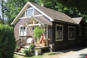
- The W.J. Walker House is a rustic cottage at the eastern end of Deer Lake and is now located within Deer Lake Park. It is a one-and-a-half-storey wood-frame shingle-clad vernacular structure.
- Associated Dates
- 1907
- Formal Recognition
- Heritage Designation, Community Heritage Register
- Other Names
- William & Olive Walker Residence
- Street View URL
- Google Maps Street View
- Repository
- Burnaby Heritage Planning
- Other Names
- William & Olive Walker Residence
- Geographic Access
- Sperling Avenue
- Associated Dates
- 1907
- Formal Recognition
- Heritage Designation, Community Heritage Register
- Enactment Type
- Bylaw No. 11593
- Enactment Date
- 15/09/2003
- Description
- The W.J. Walker House is a rustic cottage at the eastern end of Deer Lake and is now located within Deer Lake Park. It is a one-and-a-half-storey wood-frame shingle-clad vernacular structure.
- Heritage Value
- The W.J. Walker House is important as it references the economic activities in the Deer Lake area prior to the development of grand mansions in Deer Lake Park. It is typical of the cottages built by workers in the market gardening and lumber-milling industries that operated around the lake primarily from 1904-1925. This is the only cottage on the shores of Deer Lake remaining from the era when these industries were the focus of the area's development. The house demonstrates the aesthetic values of Olive Walker and her husband William J. Walker, a ‘rancher’ (market gardener, poultry farmer) who built the house as a retirement home, in the quality of its construction and interior finishing. The Craftsman styling of the house was a popular design vocabulary of the time and reflected the modern taste and values of the owner. The construction of the house also illustrates the use of locally milled lumber. The extant cold safe at the side of house is indicative of food storage methods in the early twentieth century and provides insight to the everyday domestic lives of people at this time.
- Defining Elements
- Key elements that define the heritage character of the W.J. Walker House include its: - location close to the lake and the site of the Deer Lake Lumber Company where the wood for construction of the house was milled - Craftsman style characteristics such as the house's orientation (front gable facing the street) and the combination of gable and double-pitched shed roofs - front entrance with its gabled porch supported by distinctive oversized diagonal brackets, and substantial front door of Douglas fir decorated with hand forged iron plates - cedar shingle siding - multiple-assembly wooden-sash casement windows with transoms - projecting cold safe - interior finishing that dates to the original construction of the house, such as the diagonally laid tongue-and-groove Douglas fir ceilings, wood panelled walls, and Clayburn brick fireplace
- Historic Neighbourhood
- Burnaby Lake (Historic Neighbourhood)
- Planning Study Area
- Morley-Buckingham Area
- Function
- Primary Current--Single Dwelling
- Primary Historic--Single Dwelling
- Community
- Burnaby
- Cadastral Identifier
- P.I.D. No. 017-105-773 Legal Description: Parcel 'A' (Reference Plan 3703), District Lot 85, Group 1, Except: Firstly: Parcel 'One' (Explanatory Plan 11350) Secondly: Parcel 2 (Reference Plan 35549) Group 1, New Westminster District.
- Boundaries
- The W.J. Walker House is comprised of a single municipally-owned property located at 5255 Sperling Avenue, Burnaby.
- Area
- 2,005.02
- Contributing Resource
- Building
- Landscape Feature
- Ownership
- Public (local)
- Documentation
- Heritage Site Files: PC77000 20. City of Burnaby Planning and Building Department, 4949 Canada Way, Burnaby, B.C., V5G 1M2
- Street Address
- 5255 Sperling Avenue
- Street View URL
- Google Maps Street View
Images
Lake City Neighbourhood
https://search.heritageburnaby.ca/link/landmark702
- Repository
- Burnaby Heritage Planning
- Associated Dates
- 1925-1954
- Heritage Value
- When the Lake City Industrial Park first opened in the 1950's, it was a fairly isolated industrial enclave with convenient access to rail and road transportation routes. The sense of entrepreneurial flare and success that was anticipated for the area is evident in the naming of local streets which include "Production", "Enterprise" and "Venture". The anticipated potential of the area was also demonstrated by the inclusion of many significant development amenities of the time, such as paved streets, site landscaping, rail service, natural gas service, and architectural controls.
- Planning Study Area
- Lake City Area
Images
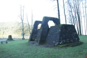
North Pacific Lumber Company Ruins
https://search.heritageburnaby.ca/link/landmark627
- Repository
- Burnaby Heritage Planning
- Geographic Access
- Barnet Road
- Associated Dates
- 1909
- Description
- Industrial building.
- Heritage Value
- Located on the shore of Burrard Inlet, these poured concrete piers of the smokestack burner and the former boiler and plant of the North Pacific Lumber Company are among the only remains of the once-thriving industrial site located on the waterfront on the south shore of Burrard Inlet. The sawmill and the Village of Barnet were initiated by David MacLaren, a wealthy lumberman from Buckingham, Quebec, who had previously established the Fraser Mills in Coquitlam in 1889. McLaren gambled that a sawmill on the main line of the C.P.R near Vancouver would serve the Canadian domestic market and be a profitable venture. The North Pacific Lumber Company established itself on this peninsula on Burrard Inlet and was fully operational in 1900. In 1909, the mill was completely burned out by a fire starting in the boiler room. Immediately the plant was rebuilt, modern in every respect and absolutely fireproof, as the entire power plant and boiler room was built of reinforced concrete and steel, of which these ruins are the last remains. The plant closed during the First World War and reopened as the Barnet Lumber Company in 1925 only to close forever in 1931 after a strike during the Great Depression.
- Locality
- Barnet
- Historic Neighbourhood
- Barnet (Historic Neighbourhood)
- Planning Study Area
- Burnaby Mountain Area
Images
Barnet Neighbourhood
https://search.heritageburnaby.ca/link/landmark716
- Repository
- Burnaby Heritage Planning
- Associated Dates
- 1889-1904
- Heritage Value
- The North Pacific Lumber Company in Barnet was one of Burnaby's first industrial developments and one of the largest in the British Empire. Partners James MacLaren and Frank Ross built the mill in 1889 (activated in 1899) as a requirement for obtaining 84,000 acres of timber rights in northern BC. Due to the mill's isolation, the firm built homes for its employees with families and bunkhouses for the bachelors which separated Caucasian workers from Chinese and Sikh workers. Barnet became a distinct company town with its own general store, school, post office, community hall and telephone exchange.
- Historic Neighbourhood
- Barnet (Historic Neighbourhood)
- Planning Study Area
- Burnaby Mountain Area
Images
BCER Eburne Line
https://search.heritageburnaby.ca/link/landmark771
- Repository
- Burnaby Heritage Planning
- Associated Dates
- 1909
- Heritage Value
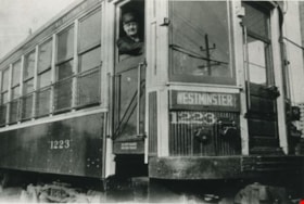
- In 1908, construction began on the British Columbia Electric Railway Eburne tramline which was to connect Eburne (now known as Marpole) with New Westminster. It opened on September 15, 1909 and its tracks were built across the bog of the Fraser Arm district with little regard to the fact that virtually no one lived there. However, within one year an hourly passenger service, a milk train and three-times weekly freight service used this level fast-running connector. With the completion of the Chilliwack interurban line and various other steam railroads which were funnelled onto this line it became one of the most important industrial freight lines in the Lower Mainland.
- Historic Neighbourhood
- Fraser Arm (Historic Neighbourhood)
- Planning Study Area
- Big Bend Area
Images
Broadview Neighbourhood
https://search.heritageburnaby.ca/link/landmark687
- Repository
- Burnaby Heritage Planning
- Associated Dates
- 1925-1954
- Heritage Value
- Development in the Broadview area slowed during World War Two, but after the war, the area became home to a number of industrial sites. The first major plant to be built here was the Dominion Bridge Company which opened in 1930.
- Historic Neighbourhood
- Broadview (Historic Neighbourhood)
- Planning Study Area
- Cascade-Schou Area
Images
Burnaby South High School
https://search.heritageburnaby.ca/link/landmark770
- Repository
- Burnaby Heritage Planning
- Associated Dates
- 1922-1988
- Street View URL
- Google Maps Street View
- Repository
- Burnaby Heritage Planning
- Geographic Access
- Southoaks Crescent
- Associated Dates
- 1922-1988
- Heritage Value
- Burnaby South and Burnaby North were Burnaby's first high schools. The first rooms of the school were built in 1922 on the same grounds as the Kingsway East Elementary School. In 1940, a two-storey building was erected and additions were made in 1963, 1967 and 1972. Kingsway East closed in 1925 and its buildings were used by the high school for Industrial Arts and Home Economics. In the early 1990s, a new "urban education centre" (Burnaby South/B.C. School for the Deaf) was opened, replacing the old Burnaby South High School.
- Historic Neighbourhood
- Edmonds (Historic Neighbourhood)
- Planning Study Area
- Kingsway-Beresford Area
- Street Address
- 6650 Southoaks Crescent
- Street View URL
- Google Maps Street View
Images
Lochdale Neighbourhood
https://search.heritageburnaby.ca/link/landmark743
- Repository
- Burnaby Heritage Planning
- Associated Dates
- 1905-1924
- Heritage Value
- "Picturesquely situated on the south-westerly slope of the highest hill on the Burrard Peninsula is a district that in many ways resembles the early pioneer settlements…its centre is at the intersection of east Hastings Street and Sperling Avenue. Only a few years ago a dense forest covered this area and the settlers were few and some distance apart. After the war working men began to enter the Lochdale woods in quest of cheap home-sites. Today there are more than 400 residents in the district who combine to make a happy contented industrious community living on the edge of a big city yet enjoying the life offered by the country...The Community Hall is the centre of all social activities. Dances, concerts and other forms of entertainment are all there...Curtis Street runs from Sperling Avenue up to the hill, locally known as Hastings Grove. From the top on a clear day there is a view for miles around." ~ From the Sunday Province, March 8, 1925.
- Historic Neighbourhood
- Lochdale (Historic Neighbourhood)
- Planning Study Area
- Lochdale Area
Images
Masonic Cemetery
https://search.heritageburnaby.ca/link/landmark622
- Repository
- Burnaby Heritage Planning
- Description
- Cemetery site.
- Associated Dates
- 1924
- Street View URL
- Google Maps Street View
- Repository
- Burnaby Heritage Planning
- Geographic Access
- Halifax Street
- Associated Dates
- 1924
- Description
- Cemetery site.
- Heritage Value
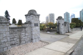
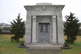
- Tucked into a sloping site in a zone that is now transitional between light industrial and residential uses, the Masonic Cemetery is a beautifully landscaped oasis. Two outstanding features of this cemetery are the Woodward mausoleum, constructed in 1924, and the 1930s entrance gates. These substantial gates are constructed of random-coursed granite, and mark the cemetery’s main entrance off Douglas Road. An elaborate granite mausoleum, built for the prominent Woodward family, is located on axis with the main entry, at the brow of the slope. The Egyptian Revival style of the mausoleum was inspired by the opening of Tutankamun’s tomb just two years earlier, a discovery that sparked world-wide Egyptomania. The Woodward’s department store dynasty was founded by Charles Woodward (1852-1937), who visited Vancouver in 1891 and bought two lots for a store. Woodward’s drug department opened in 1895. In 1901, he took an option on a lot at the corner of Hastings and Abbott Streets and incorporated as Woodward’s Department Stores, which opened in November 1903. The family continued to run the business until 1993, when it went bankrupt and was sold to the Hudson’s Bay Company. A number of the Woodward family are interred here.
- Locality
- Vancouver Heights
- Historic Neighbourhood
- Vancouver Heights (Historic Neighbourhood)
- Planning Study Area
- Willingdon Heights Area
- Area
- 60137.87
- Contributing Resource
- Building
- Landscape Feature
- Ownership
- Private
- Street Address
- 4305 Halifax Street
- Street View URL
- Google Maps Street View
Images
Mortimer-Lamb House
https://search.heritageburnaby.ca/link/landmark494
- Repository
- Burnaby Heritage Planning
- Description
- The Mortimer-Lamb House is a one and one half-storey, Arts and Crafts-style residence with a steeply pitched, side-gabled roof. The original cottage form has been enlarged with a later addition on the west side of the house. Located next to the Burnaby Lake Regional Park Wildlife Rescue Care Centre…
- Associated Dates
- c.1922
- Formal Recognition
- Community Heritage Register
- Other Names
- Harold & Katherine Mortimer-Lamb Residence
- Street View URL
- Google Maps Street View
- Repository
- Burnaby Heritage Planning
- Other Names
- Harold & Katherine Mortimer-Lamb Residence
- Geographic Access
- Glencarin Drive
- Associated Dates
- c.1922
- Formal Recognition
- Community Heritage Register
- Enactment Type
- Council Resolution
- Enactment Date
- 26/05/2003
- Description
- The Mortimer-Lamb House is a one and one half-storey, Arts and Crafts-style residence with a steeply pitched, side-gabled roof. The original cottage form has been enlarged with a later addition on the west side of the house. Located next to the Burnaby Lake Regional Park Wildlife Rescue Care Centre, the house has picturesque views of Burnaby Lake.
- Heritage Value
- Built circa 1922, the Mortimer-Lamb House is valued for its association with first owners, Harold Mortimer-Lamb (1872-1970), and his wife, Katherine Mary Mortimer-Lamb (1873-1939). Born in Leatherhead, Surrey, England, Harold Mortimer-Lamb immigrated to Canada in 1889. Seven years later in Vancouver, he married Katherine Mary Lindsay, a native of Winnipeg. Mortimer-Lamb was a key figure in the B.C. mining industry, serving as Secretary of the Mining Association of B.C. between 1900 and 1945, and also as the Secretary of the Canadian Institute of Mining and Metallurgy. In addition to his professional life, Mortimer-Lamb was a pioneer art photographer and was among Canada's leading art critics, and this house served as a central gathering place for renowned Canadian artists of the day. Mortimer-Lamb’s daughter, Molly Lamb Bobak (born 1922), became a renowned watercolourist, and was the only woman ever hired as an official Canadian war artist. The Mortimer-Lamb House is a significant example of the work of noted architect, Samuel Maclure (1860-1929) and his partner, Ross Lort (1889-1969). Maclure, who was a close friend of the Mortimer-Lamb family, was British Columbia's leading residential architect, and was renowned for his high quality designs for prominent citizens in both Vancouver and Victoria. Maclure was a leading exponent of the Art and Crafts design movement in B.C., and established a sophisticated local variation of residential architecture. The Mortimer-Lamb House was designed at the time when Maclure was in partnership with Ross Lort. In 1907, Lort began working for Maclure's firm as a draftsman, and by 1920 was in charge of Maclure's Vancouver office. Lort's architectural career spanned some sixty-years, and he designed some of the province's most familiar houses, apartments, institutions and places of worship. The Mortimer-Lamb House is also a significant local example of the Arts and Crafts style, and incorporates elements such as board-and-batten siding on the ground floor, shingled gables and leaded casement windows. It is a testament to the domestic architecture built outside of established suburbs during the post-First World War era, typically modest in scale and representative of middle-class residential ideals.
- Defining Elements
- Key elements that define the heritage character of the Mortimer-Lamb House include its: - treed setting with views of Burnaby Lake - residential form, scale and massing as expressed by its one and one-half storey height, rectangular plan and steeply pitched side-gabled roof - wood-frame construction - Arts and Crafts elements such as board-and-batten siding on the ground floor, cedar shingles in the gables and open soffits - original straight-leaded casement windows in single and multiple-assembly - internal red-brick chimney with corbelled cap
- Historic Neighbourhood
- Burnaby Lake (Historic Neighbourhood)
- Planning Study Area
- Burnaby Lake Area
- Organization
- Mining Association of B.C.
- G.F. and J. Galt Limited
- Architect
- Samuel Maclure
- Ross Lort
- Function
- Primary Historic--Single Dwelling
- Primary Current--Single Dwelling
- Community
- Burnaby Lake
- Cadastral Identifier
- P.I.D.002-977-788
- Boundaries
- The Mortimer-Lamb House is comprised of a single residential lot located at 5180 Glencairn Drive, Burnaby.
- Area
- 5652.78
- Contributing Resource
- Building
- Ownership
- Private
- Documentation
- City of Burnaby Planning and Building Department, Heritage Site Files
- Street Address
- 5180 Glencarin Drive
- Street View URL
- Google Maps Street View
Images
Aeroplane view of the Barnet Lumber Co.
https://search.heritageburnaby.ca/link/archivedescription38679
- Repository
- City of Burnaby Archives
- Date
- 1927
- Collection/Fonds
- Burnaby Historical Society fonds
- Description Level
- Item
- Physical Description
- 1 photograph : sepia postcard ; 8.9 x 13.4 cm
- Scope and Content
- Aerial photographic postcard of Barnet Lumber Company's Mill. The handwritten caption on the lower left corner of the postcard reads: "Aeroplane view of the Barnet Lumber Co. Ltd./ Barnet BC." The handwritten caption on the lower right corner reads: "Copyright 1927/ Pacific Airway Ltd./ Vancouver …
- Repository
- City of Burnaby Archives
- Date
- 1927
- Collection/Fonds
- Burnaby Historical Society fonds
- Subseries
- North Burnaby Board of Trade subseries
- Physical Description
- 1 photograph : sepia postcard ; 8.9 x 13.4 cm
- Description Level
- Item
- Record No.
- 476-022
- Access Restriction
- No restrictions
- Reproduction Restriction
- No known restrictions
- Accession Number
- BHS2005-8
- Scope and Content
- Aerial photographic postcard of Barnet Lumber Company's Mill. The handwritten caption on the lower left corner of the postcard reads: "Aeroplane view of the Barnet Lumber Co. Ltd./ Barnet BC." The handwritten caption on the lower right corner reads: "Copyright 1927/ Pacific Airway Ltd./ Vancouver B.C.".
- Subjects
- Aerial Photographs
- Industries - Forestry
- Buildings - Industrial - Mills
- Documentary Artifacts - Postcards
- Industries - Logging/lumber
- Names
- Barnet Mill
- Media Type
- Photograph
- Photographer
- Pacific Airway Ltd.
- Responsibility
- Published by the Gowen, Sutton Co. Ltd., Vancouver
- Notes
- Transcribed title
- Geographic Access
- Barnet Village
- Texaco Drive
- Street Address
- 8059 Texaco Drive
- Historic Neighbourhood
- Barnet (Historic Neighbourhood)
- Planning Study Area
- Burnaby Mountain Area
Images
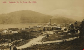
Barnet, B.C. from the Hill
https://search.heritageburnaby.ca/link/archivedescription38345
- Repository
- City of Burnaby Archives
- Date
- [1907]
- Collection/Fonds
- Burnaby Historical Society fonds
- Description Level
- Item
- Physical Description
- 1 photograph : sepia postcard ; 8 x 13 cm
- Scope and Content
- Photograph of the village of Barnet at the mill. The caption stamped at the top of the card reads: "Barnet, B.C. from the Hill." The Barnet Mill was called the North Pacific Lumber Company from 1889 to 1914.
- Repository
- City of Burnaby Archives
- Date
- [1907]
- Collection/Fonds
- Burnaby Historical Society fonds
- Subseries
- Charles Lee subseries
- Physical Description
- 1 photograph : sepia postcard ; 8 x 13 cm
- Description Level
- Item
- Record No.
- 411-004
- Access Restriction
- No restrictions
- Reproduction Restriction
- No known restrictions
- Accession Number
- BHS2000-13
- Scope and Content
- Photograph of the village of Barnet at the mill. The caption stamped at the top of the card reads: "Barnet, B.C. from the Hill." The Barnet Mill was called the North Pacific Lumber Company from 1889 to 1914.
- Subjects
- Documentary Artifacts - Postcards
- Buildings - Industrial - Mills
- Geographic Features - Inlets
- Industries - Forestry
- Industries - Logging/lumber
- Names
- Barnet Mill
- Media Type
- Photograph
- Photographer
- Timms Photographic Co.
- Notes
- Title taken from caption
- Geographic Access
- Barnet Village
- Texaco Drive
- Street Address
- 8059 Texaco Drive
- Historic Neighbourhood
- Barnet (Historic Neighbourhood)
- Planning Study Area
- Burnaby Mountain Area
Images
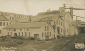
Barnet Lumber mill
https://search.heritageburnaby.ca/link/museumdescription15232
- Repository
- Burnaby Village Museum
- Date
- [192-] (date of original), copied 2004
- Collection/Fonds
- In the Shadow by the Sea collection
- Description Level
- Item
- Physical Description
- 1 photograph (tiff) : 300 dpi
- Scope and Content
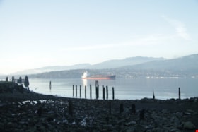
- Photograph of the Barnet Lumber Company mill in operation. C.P.R. railroad tracks are visible in the foreground and trees on the north shore of Burrard Inlet are visible in the distance. Plumes of smoke are rising from the mill chimneys.
- Repository
- Burnaby Village Museum
- Collection/Fonds
- In the Shadow by the Sea collection
- Description Level
- Item
- Physical Description
- 1 photograph (tiff) : 300 dpi
- Scope and Content
- Photograph of the Barnet Lumber Company mill in operation. C.P.R. railroad tracks are visible in the foreground and trees on the north shore of Burrard Inlet are visible in the distance. Plumes of smoke are rising from the mill chimneys.
- Names
- Barnet Lumber Company
- Geographic Access
- Burrard Inlet
- Accession Code
- BV019.32.51
- Access Restriction
- No restrictions
- Reproduction Restriction
- No known restrictions
- Date
- [192-] (date of original), copied 2004
- Media Type
- Photograph
- Historic Neighbourhood
- Barnet (Historic Neighbourhood)
- Planning Study Area
- Burnaby Mountain Area
- Notes
- Title based on contents of photograph
Images
Boundary Road Lumber Mill
https://search.heritageburnaby.ca/link/archivedescription38262
- Repository
- City of Burnaby Archives
- Date
- 1908
- Collection/Fonds
- Burnaby Historical Society fonds
- Description Level
- Item
- Physical Description
- 1 photograph : sepia ; 9 x 12 cm on 12.5 x 15 cm backing
- Scope and Content
- Photograph of an unidentified man standing in the forefront with a jersey cow to the right, while a row of cabins and cleared tress can be seen in the background. A caption written above the photograph reads: "Boundary Road Lumber Mill owned by E.W. Nicholson." Underneath the photograph is writte…
- Repository
- City of Burnaby Archives
- Date
- 1908
- Collection/Fonds
- Burnaby Historical Society fonds
- Subseries
- Margaret McCallum subseries
- Physical Description
- 1 photograph : sepia ; 9 x 12 cm on 12.5 x 15 cm backing
- Description Level
- Item
- Record No.
- 375-024
- Access Restriction
- No restrictions
- Reproduction Restriction
- No known restrictions
- Accession Number
- BHS1986-42
- Scope and Content
- Photograph of an unidentified man standing in the forefront with a jersey cow to the right, while a row of cabins and cleared tress can be seen in the background. A caption written above the photograph reads: "Boundary Road Lumber Mill owned by E.W. Nicholson." Underneath the photograph is written: "The first Jersey cow on the farm." On the back of the photograph it is noted that the buildings in the background were workmen's buildings.
- Media Type
- Photograph
- Notes
- Title based on caption
- Geographic Access
- Boundary Road
- Still Creek
- Street Address
- 2550 Boundary Road
- Historic Neighbourhood
- Broadview (Historic Neighbourhood)
- Planning Study Area
- West Central Valley Area
Images
The Clark log carriage
https://search.heritageburnaby.ca/link/museumlibrary2238
- Repository
- Burnaby Village Museum
- Collection
- Special Collection
- Material Type
- Textual Record
- Accession Code
- HV977.29.23
- Call Number
- 680 CLA
- Author
- Clark Bros. Co.
- Place of Publication
- Belmont, N.Y.
- Publisher
- Clark Bros
- Publication Date
- 1900
- Printer
- The F. W. Roberts Co.
- Physical Description
- 16 p. : ill. : 23 cm.
- Library Subject (LOC)
- Logging
- Subjects
- Industries
- Industries - Logging/lumber
Clark portable band mill
https://search.heritageburnaby.ca/link/museumlibrary4888
- Repository
- Burnaby Village Museum
- Collection
- Special Collection
- Material Type
- Book
- Accession Code
- HV977.29.6
- Call Number
- 671 CLA
- Author
- Clark Bros. Co.
- Place of Publication
- Olean, N.Y.
- Publisher
- Clark Brothers Co.
- Publication Date
- 1920
- Physical Description
- 8 p. : ill. : 29 cm.
- Library Subject (LOC)
- Lumber
- Millwork (Woodwork)
- Milling machinery
- Band saws
- Catalogs
- Subjects
- Industries
- Industries - Logging/lumber
- Notes
- "Bulletin No. 18 A" -- Cover
- "More lumber -- From the same amount of logs." -- Cover
- "Better prices -- The lumber is better sawn." -- Cover
- "Less mfg. cost -- On account of cheap logging, small plant upkeep, and increased production per man." -- Cover





![Barnet Lumber mill, [192-] (date of original), copied 2004 thumbnail](/media/hpo/_Data/_BVM_Images/2019/2019_0032_0051_001.jpg?width=280)
