More like 'Alfred Bingham's writings - Track 2'
Narrow Results By
Decade
- 2020s 86
- 2010s 46
- 2000s 485
- 1990s
- 1980s 391
- 1970s 734
- 1960s 287
- 1950s
- 1940s 464
- 1930s 355
- 1920s 390
- 1910s 476
- 1900s 189
- 1890s 30
- 1880s 50
- 1870s 4
- 1860s 2
- 1850s 1
- 1840s 1
- 1830s 1
- 1820s 1
- 1810s 1
- 1800s 1
- 1790s 1
- 1780s 1
- 1770s 1
- 1760s 1
- 1750s 1
- 1740s 1
- 1730s 1
- 1720s 1
- 1710s 1
- 1700s 1
- 1690s 1
- 1680s 1
- 1670s 1
- 1660s 1
- 1650s 1
- 1640s
- 1630s 1
- 1620s 1
- 1610s 1
- 1600s 1
Interview with Mayor Derek Corrigan by Kathy Bossort January 28, 2016 - Track 7
https://search.heritageburnaby.ca/link/oralhistory686
- Repository
- City of Burnaby Archives
- Date Range
- 1995-2015
- Length
- 0:14:33
- Summary
- This portion of the interview is about Mayor Corrigan talking about the event in November 1995 when the Memorandum of Understanding was signed, and about the legacy that was created. He discusses what conservation means to him, Burnaby’s sustainability strategy, and the role MetroVancouver plays in…
- Repository
- City of Burnaby Archives
- Summary
- This portion of the interview is about Mayor Corrigan talking about the event in November 1995 when the Memorandum of Understanding was signed, and about the legacy that was created. He discusses what conservation means to him, Burnaby’s sustainability strategy, and the role MetroVancouver plays in protecting conservation areas.
- Date Range
- 1995-2015
- Length
- 0:14:33
- Names
- Simon Fraser University
- Subjects
- Geographic Features - Parks
- Government
- Land
- Geographic Access
- Burnaby Mountain Conservation Area
- Interviewer
- Bossort, Kathy
- Interview Date
- January 28, 2016
- Scope and Content
- Recording is of an interview with Mayor Derek Corrigan conducted by Kathy Bossort. Derek Corrigan was one of 23 participants interviewed as part of the Community Heritage Commission’s Burnaby Mountain Oral History Project. The interview is mainly about Mayor Corrigan talking about the history and value of protecting the environment and green space in Burnaby, and the different positions held by the City and SFU about land use and control on Burnaby Mountain between 1964 and 1995. He talks about the increasing awareness that a solution needed to be found that gave certainty to the protection of the conservation area on Burnaby Mountain. Mayor Corrigan also talks about what conservation means to him, the role that the Centennial Pavilion area plays on Burnaby Mountain, and the future for the urban forest on Burnaby Mountain. Other topics include his childhood, education, formative events in his life, and his career in politics.
- Biographical Notes
- Derek Corrigan was born and grew up in Vancouver. He attended a number of elementary schools in East Vancouver, Queen Elizabeth Elementary School (Gr. 4-7) and Sir Charles Tupper High School. He attended UBC, majoring in philosophy and political science, and after travel in Europe, successfully applied to enter law school without completing his bachelors degree. He graduated in 1977, articled with Jim Lorimer in Burnaby and was called to the bar in 1978. In 1977 Derek Corrigan and his wife Kathy moved to Burnaby, first to the Stoney Creek neighborhood and then to a home on the South Slope where they raised their family of four children. Derek Corrigan first ran for Burnaby Council in 1979 with the Burnaby Citizens Association, and after three more tries was elected to council in 1987. He has served Burnaby for 28 years, first as a councillor and then as mayor since 2002. During his career he has served on many committees at the local, regional and national levels.
- Total Tracks
- 9
- Total Length
- 1:31:24
- Interviewee Name
- Corrigan, Derek
- Interview Location
- Mayor’s office at Burnaby City Hall
- Interviewer Bio
- Kathy Bossort is a retired archivist living in Ladner, BC. She worked at the Delta Museum and Archives after graduating from SLAIS (UBC) in 2001 with Masters degrees in library science and archival studies. Kathy grew up in Calgary, Alberta, and, prior to this career change, she lived in the West Kootenays, earning her living as a cook for BC tourist lodges and work camps. She continues to be interested in oral histories as a way to fill the gaps in the written record and bring richer meaning to history.
- Collection/Fonds
- Community Heritage Commission Special Projects fonds
- Media Type
- Sound Recording
Audio Tracks
Track seven of interview with Mayor Derek Corrigan
Track seven of interview with Mayor Derek Corrigan
https://search.heritageburnaby.ca/media/hpo/_Data/_Archives_Oral_Histories/_Unrestricted/MSS196-018/MSS196-018_Track_7.mp3![Land surveyor on a road, [1999] thumbnail](/media/hpo/_Data/_Archives_Images/_Unrestricted/535/535-3313.jpg?width=280)
Land surveyor on a road
https://search.heritageburnaby.ca/link/archivedescription98246
- Repository
- City of Burnaby Archives
- Date
- [1999]
- Collection/Fonds
- Burnaby NewsLeader photograph collection
- Description Level
- Item
- Physical Description
- 1 photograph (tiff) : b&w
- Scope and Content
- Photograph of an unidentified land surveyor standing behind a land surveying total station at the curve of a road.
- Repository
- City of Burnaby Archives
- Date
- [1999]
- Collection/Fonds
- Burnaby NewsLeader photograph collection
- Physical Description
- 1 photograph (tiff) : b&w
- Description Level
- Item
- Record No.
- 535-3313
- Access Restriction
- No restrictions
- Reproduction Restriction
- No restrictions
- Accession Number
- 2018-12
- Scope and Content
- Photograph of an unidentified land surveyor standing behind a land surveying total station at the curve of a road.
- Media Type
- Photograph
- Notes
- Title based on contents of photograph
- Collected by editorial for use in a September 1999 issue of the Burnaby NewsLeader
Images
![Land surveyor on a road, [1999] thumbnail](/media/hpo/_Data/_Archives_Images/_Unrestricted/535/535-3313.jpg)
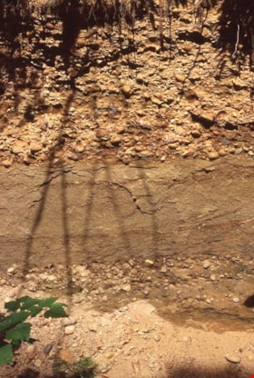
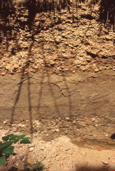
Sediment layers on Burnaby Mountain
https://search.heritageburnaby.ca/link/archivedescription97811
- Repository
- City of Burnaby Archives
- Date
- 1996
- Collection/Fonds
- Burnaby Mountain Preservation Society fonds
- Description Level
- Item
- Physical Description
- 1 photograph : col. slide ; 35 mm
- Scope and Content
- Photograph of sediment layers.
- Repository
- City of Burnaby Archives
- Date
- 1996
- Collection/Fonds
- Burnaby Mountain Preservation Society fonds
- Physical Description
- 1 photograph : col. slide ; 35 mm
- Description Level
- Item
- Record No.
- 629-012
- Access Restriction
- No restrictions
- Reproduction Restriction
- Reproduce for fair dealing purposes only
- Accession Number
- 2006-13
- Scope and Content
- Photograph of sediment layers.
- Subjects
- Land
- Media Type
- Photograph
- Notes
- Stamp on slide reads: "July 08, 1996."
- Geographic Access
- Burnaby Mountain Conservation Area
- Planning Study Area
- Burnaby Mountain Area
Images
6900 [and] 7000 bk Hastings St. / 7000 blk Pandora St. 200 [and] 300 blks Cliff Ave Burnaby
https://search.heritageburnaby.ca/link/archivedescription94205
- Repository
- City of Burnaby Archives
- Date
- November 1993 - December 1993
- Collection/Fonds
- Grover, Elliott & Co. Ltd. fonds
- Description Level
- File
- Physical Description
- 96 photographs : col. negatives ; 35 mm
- Scope and Content
- Photographs of various residential and commercial streets in Burnaby.
- Repository
- City of Burnaby Archives
- Date
- November 1993 - December 1993
- Collection/Fonds
- Grover, Elliott & Co. Ltd. fonds
- Physical Description
- 96 photographs : col. negatives ; 35 mm
- Description Level
- File
- Record No.
- 622-080
- Access Restriction
- No restrictions
- Reproduction Restriction
- No restrictions
- Accession Number
- 2017-39
- Scope and Content
- Photographs of various residential and commercial streets in Burnaby.
- Subjects
- Geographic Features - Roads
- Buildings - Residential - Apartments
- Buildings - Residential - Houses
- Buildings - Commercial
- Media Type
- Photograph
- Notes
- Transcribed title
- Title transcribed from envelope photographs were originally housed in
- File no. 93-455-B
- Note on negative envelope housing photographs 622-080-1 : 622-080-74 reads: "93-11-26 / Inlet Dr/Hastings, Bby, / 93-455-B"
- Note on negative envelope housing photographs 622-080-75 : 622-080-96 reads: "93-12-01 / Comp's / 93-455"
- Photographer identified as "K.H."
- Geographic Access
- Hastings Street
- Cliff Avenue
- Pandora Street
7641-7651 Royal Oak Ave
https://search.heritageburnaby.ca/link/archivedescription93769
- Repository
- City of Burnaby Archives
- Date
- July 30, 1992
- Collection/Fonds
- Grover, Elliott & Co. Ltd. fonds
- Description Level
- File
- Physical Description
- 25 photographs : col. negatives ; 35 mm
- Scope and Content
- Photographs of the commercial properties located between 7641 and 7651 Royal Oak Avenue. Stores visible in the photographs include: Buy Low Foods, Mega Movies, and Chevron service station.
- Repository
- City of Burnaby Archives
- Date
- July 30, 1992
- Collection/Fonds
- Grover, Elliott & Co. Ltd. fonds
- Physical Description
- 25 photographs : col. negatives ; 35 mm
- Description Level
- File
- Record No.
- 622-053
- Access Restriction
- No restrictions
- Reproduction Restriction
- No restrictions
- Accession Number
- 2017-39
- Scope and Content
- Photographs of the commercial properties located between 7641 and 7651 Royal Oak Avenue. Stores visible in the photographs include: Buy Low Foods, Mega Movies, and Chevron service station.
- Subjects
- Buildings - Commercial
- Buildings - Commercial - Service Stations
- Buildings - Commercial - Stores
- Geographic Features - Roads
- Media Type
- Photograph
- Photographer
- Young, Richard
- Notes
- Transcribed title
- Title transcribed from envelope photographs were originally housed in
- File no. 92-287-B
- Geographic Access
- Royal Oak Avenue
- Historic Neighbourhood
- Alta Vista (Historic Neighbourhood)
- Planning Study Area
- Maywood Area

Bell's Dry Goods
https://search.heritageburnaby.ca/link/museumdescription14036
- Repository
- Burnaby Village Museum
- Date
- 11 Aug. 1994
- Collection/Fonds
- Burnaby Village Museum fonds
- Description Level
- Item
- Physical Description
- 1 videocassette (62 min., 50 sec.) : VHS, col., sd.
- Scope and Content
- Film footage of an interview conducted and recorded by Burnaby Village Museum curator Colin Stevens with Burnaby residents gathered inside of Bell's Dry Goods store on the site of Burnaby Village Museum. Burnaby residents were customers and friends of Mr. and Mrs. Bell and included: Jim Agnew; Mary…
- Repository
- Burnaby Village Museum
- Collection/Fonds
- Burnaby Village Museum fonds
- Subseries
- Bell's research files subseries
- Description Level
- Item
- Physical Description
- 1 videocassette (62 min., 50 sec.) : VHS, col., sd.
- Scope and Content
- Film footage of an interview conducted and recorded by Burnaby Village Museum curator Colin Stevens with Burnaby residents gathered inside of Bell's Dry Goods store on the site of Burnaby Village Museum. Burnaby residents were customers and friends of Mr. and Mrs. Bell and included: Jim Agnew; Mary Agne; May and Bill Long; Mel Coutts; Lois Coutts; Isobel Coutts and Aubrey Coutts. These residents all lived in the area of the building and knew the owners between 1920 and 1950. Residents recall the layout and furnishings of the interior of the building when it was operated as Bell's Dry Goods (1925 to 1937), Jean's Grocery Store [?], Whitechurch Hardware (1937-1973). Colin Stevens is particularly interested in gathering information on the layout and furnishings in Bell's since the museum intends to restore the building and display to the 1920s era.
- Creator
- Stevens, Colin
- Subjects
- Buildings - Commercial
- Buildings - Commercial - Grocery Stores
- Buildings - Commercial - Hardware Stores
- Names
- Agnew, Jim
- Agnew, Mary
- Coutts, Mel
- Coutts, Lois Hollands
- Coutts, Aubrey
- Coutts, Isobel
- Long, May Walker
- Long, Bill
- Stevens, Colin
- Accession Code
- BV020.5.737
- Access Restriction
- Restricted access
- Reproduction Restriction
- May be restricted by third party rights
- Date
- 11 Aug. 1994
- Media Type
- Moving Images
- Notes
- Title based on contents
- Label on videocassette reads: "Bells' Dry Goods" / "Interview with People / who used to shop there / at / "Bells' Dry Goods" / 6th St. Burnaby / 1994 Aug 11 Colin Stevens"
Images

Interview with Cice Brown, May 13, 2005 - Track 2
https://search.heritageburnaby.ca/link/museumdescription4477
- Repository
- Burnaby Village Museum
- Date
- 1930-1949 (interview content), interviewed May 10, 2005
- Collection/Fonds
- Burnaby Village Museum fonds
- Description Level
- Item
- Physical Description
- 1 sound recording (mp3) (0:06:11 min)
- Scope and Content
- Track 2: This portion of the recording pertains to responsibilities, chores, and money. Cice recalls her chores, and how she spent her allowance. She describes her jobs in Mr. Pitman’s drygoods stores, on Kingsway and on Jubilee Ave., and in Anne Reid’s candy shop. Asked about church, Cice discuss…
- Repository
- Burnaby Village Museum
- Collection/Fonds
- Burnaby Village Museum fonds
- Series
- Museum Oral Histories series
- Subseries
- Growing Up in Burnaby subseries
- Description Level
- Item
- Physical Description
- 1 sound recording (mp3) (0:06:11 min)
- Material Details
- Interviewer: Tom Gooden Interviewee: Cice Brown Date of interview: May 13, 2005 Total Number of Tracks: 7 Total length of all Tracks: 0:40:19
- Scope and Content
- Track 2: This portion of the recording pertains to responsibilities, chores, and money. Cice recalls her chores, and how she spent her allowance. She describes her jobs in Mr. Pitman’s drygoods stores, on Kingsway and on Jubilee Ave., and in Anne Reid’s candy shop. Asked about church, Cice discusses her involvement with the Henderson-Jubilee United church, and C.G.I.T..
- History
- Recording of an interview with Cice Brown, interviewed by Tom Gooden on May 13 2005. This recording was completed for an exhibit, Growing Up in Burnaby, for the Burnaby Village Museum. Major themes discussed are growing up in Burnaby in the 1930s and 40s.
- Creator
- Burnaby Village Museum
- Subjects
- Buildings - Commercial - General Stores
- Buildings - Commercial - Grocery Stores
- Buildings - Commercial - Stores
- Names
- Brown, Cice Chandler
- Geographic Access
- Kingsway
- Jubilee Avenue
- Accession Code
- BV017.45.3
- Access Restriction
- No restrictions
- Date
- 1930-1949 (interview content), interviewed May 10, 2005
- Media Type
- Sound Recording
- Notes
- Title based on contents of item
Audio Tracks
Interview with Cice Brown, May 13, 2005 - Track 2, 1930-1949 (interview content), interviewed May 10, 2005
Interview with Cice Brown, May 13, 2005 - Track 2, 1930-1949 (interview content), interviewed May 10, 2005
https://search.heritageburnaby.ca/media/hpo/_Data/_BVM_Sound_Recordings/Oral_Histories/2017_0045_0003_002.mp3Interview with Janet White May 10, 2005 - Track 2
https://search.heritageburnaby.ca/link/museumdescription4468
- Repository
- Burnaby Village Museum
- Date
- [195-] (interview content), interviewed May 10, 2005
- Collection/Fonds
- Burnaby Village Museum fonds
- Description Level
- Item
- Physical Description
- 1 sound recording (mp3) (0:04:14 min)
- Scope and Content
- Track 2: This portion of the recording pertains to childhood responsibilities, chores, and early jobs, and the growth of Burnaby as experienced by a child. Janet describes her chores, and her first jobs at the PNE, Sears, and Super Value. She discusses how she used her allowance and employment inco…
- Repository
- Burnaby Village Museum
- Collection/Fonds
- Burnaby Village Museum fonds
- Series
- Museum Oral Histories series
- Subseries
- Growing Up in Burnaby subseries
- Description Level
- Item
- Physical Description
- 1 sound recording (mp3) (0:04:14 min)
- Material Details
- Interviewer: Tom Gooden Interviewee: Janet White Date of interview: May 10, 2005 Total Number of Tracks: 8 Total length of all Tracks: 0:31:34
- Scope and Content
- Track 2: This portion of the recording pertains to childhood responsibilities, chores, and early jobs, and the growth of Burnaby as experienced by a child. Janet describes her chores, and her first jobs at the PNE, Sears, and Super Value. She discusses how she used her allowance and employment incomes.
- History
- Recording of an interview with Janet White recording by Tom Gooden on May 10 2005. This recording was completed for an exhibit, Growing Up in Burnaby, for the Burnaby Village Museum. Major themes discussed are growing up in Burnaby in the 1950s.
- Creator
- Burnaby Village Museum
- Subjects
- Buildings - Commercial
- Buildings - Commercial - Grocery Stores
- Buildings - Commercial - Stores
- Names
- Gooden, Tom
- White, Janet
- Accession Code
- BV017.45.1
- Access Restriction
- No restrictions
- Reproduction Restriction
- May be restricted by third party rights
- Date
- [195-] (interview content), interviewed May 10, 2005
- Media Type
- Sound Recording
Audio Tracks
Interview with Janet White May 10, 2005 - Track 2, [195-] (interview content), interviewed May 10, 2005
Interview with Janet White May 10, 2005 - Track 2, [195-] (interview content), interviewed May 10, 2005
https://search.heritageburnaby.ca/media/hpo/_Data/_BVM_Sound_Recordings/Oral_Histories/2017_0045_0001_002.mp3Love farmhouse conservation work files subseries
https://search.heritageburnaby.ca/link/museumdescription9805
- Repository
- Burnaby Village Museum
- Date
- 1988-2000, predominant 1993-1997
- Collection/Fonds
- Burnaby Village Museum fonds
- Description Level
- Subseries
- Scope and Content
- Subseries consists of conservation records pertaining to the acquistion, relocation, restoration, financing and preservation of the Love farmhouse at the Burnaby Village Museum. Records include copies of staff, department, commission, commitee and council reports; correspondence; research; budget s…
- Repository
- Burnaby Village Museum
- Collection/Fonds
- Burnaby Village Museum fonds
- Series
- Jesse Love farmhouse series
- Description Level
- Subseries
- Material Details
- 32 cm of textual records + approx. 29 architectural drawings + 1 drawing + 1 photograph : col. laser print + 3 photographs : photocopies, hand col.
- Scope and Content
- Subseries consists of conservation records pertaining to the acquistion, relocation, restoration, financing and preservation of the Love farmhouse at the Burnaby Village Museum. Records include copies of staff, department, commission, commitee and council reports; correspondence; research; budget summaries; interior and exterior plans; contract agreements; proposals; interior and exterior finishing treatments including tin ceilings, paint and wallpaper and drainage issues.
- Subjects
- Buildings - Heritage
- Documentary Artifacts - Architectural Drawings
- Buildings - Residential
- Accession Code
- BV018.41
- Access Restriction
- Subject to FIPPA
- Reproduction Restriction
- Reproductions subject to FIPPA
- Date
- 1988-2000, predominant 1993-1997
- Media Type
- Textual Record
- Architectural Drawing
- Notes
- Title based on content of subseries
3355-3375 North Rd Burnaby
https://search.heritageburnaby.ca/link/archivedescription93891
- Repository
- City of Burnaby Archives
- Date
- June 1993
- Collection/Fonds
- Grover, Elliott & Co. Ltd. fonds
- Description Level
- File
- Physical Description
- 52 photographs : col. negatives ; 35 mm
- Scope and Content
- Photographs of the strip mall located at 3355-3375 North Road. Stores visible in the photographs include: CD Rentals and Laser Discs, Canadian 2-for-1 Pizza, Eyecrafters, North Road Dental Centre, Mike Fridays, and Penningtons.
- Repository
- City of Burnaby Archives
- Date
- June 1993
- Collection/Fonds
- Grover, Elliott & Co. Ltd. fonds
- Physical Description
- 52 photographs : col. negatives ; 35 mm
- Description Level
- File
- Record No.
- 622-074
- Access Restriction
- No restrictions
- Reproduction Restriction
- No restrictions
- Accession Number
- 2017-39
- Scope and Content
- Photographs of the strip mall located at 3355-3375 North Road. Stores visible in the photographs include: CD Rentals and Laser Discs, Canadian 2-for-1 Pizza, Eyecrafters, North Road Dental Centre, Mike Fridays, and Penningtons.
- Media Type
- Photograph
- Photographer
- Young, Richard
- Notes
- Transcribed title
- Title transcribed from envelope photographs were originally housed in
- File no. 93-273-B
- Geographic Access
- North Road
- Historic Neighbourhood
- Burquitlam (Historic Neighbourhood)
- Planning Study Area
- Lyndhurst Area
4775 Hastings St.
https://search.heritageburnaby.ca/link/archivedescription94340
- Repository
- City of Burnaby Archives
- Date
- October 1995
- Collection/Fonds
- Grover, Elliott & Co. Ltd. fonds
- Description Level
- File
- Physical Description
- 26 photographs : col. negatives ; 35 mm
- Scope and Content
- Photographs of a Pizza Hut restaurant located at 4775 Hastings Street and Honda and Toyota automotive dealerships located at 4780 Hastings Street.
- Repository
- City of Burnaby Archives
- Date
- October 1995
- Collection/Fonds
- Grover, Elliott & Co. Ltd. fonds
- Physical Description
- 26 photographs : col. negatives ; 35 mm
- Description Level
- File
- Record No.
- 622-125
- Access Restriction
- No restrictions
- Reproduction Restriction
- No restrictions
- Accession Number
- 2017-39
- Scope and Content
- Photographs of a Pizza Hut restaurant located at 4775 Hastings Street and Honda and Toyota automotive dealerships located at 4780 Hastings Street.
- Media Type
- Photograph
- Notes
- Transcribed title
- Title transcribed from envelope photographs were originally housed in
- File no. 95-247-B
- Geographic Access
- Hastings Street
- Street Address
- 4775 Hastings Street
- Historic Neighbourhood
- Capitol Hill (Historic Neighbourhood)
- Planning Study Area
- Capitol Hill Area
4780 Hastings Street
https://search.heritageburnaby.ca/link/archivedescription94341
- Repository
- City of Burnaby Archives
- Date
- July 1995
- Collection/Fonds
- Grover, Elliott & Co. Ltd. fonds
- Description Level
- File
- Physical Description
- 50 photographs : col. negatives ; 35 mm
- Scope and Content
- Photographs of the Honda and Toyota automotive dealerships located at 4780 Hastings Street. File also contains photographs of businesses located along Hastings Street, including: Liquidation World, Young Buildings Supplies and Hardware, Big-O Tires, Full Gospel Assembly Vancouver, Salza Mexican Pr…
- Repository
- City of Burnaby Archives
- Date
- July 1995
- Collection/Fonds
- Grover, Elliott & Co. Ltd. fonds
- Physical Description
- 50 photographs : col. negatives ; 35 mm
- Description Level
- File
- Record No.
- 622-126
- Access Restriction
- No restrictions
- Reproduction Restriction
- No restrictions
- Accession Number
- 2017-39
- Scope and Content
- Photographs of the Honda and Toyota automotive dealerships located at 4780 Hastings Street. File also contains photographs of businesses located along Hastings Street, including: Liquidation World, Young Buildings Supplies and Hardware, Big-O Tires, Full Gospel Assembly Vancouver, Salza Mexican Products, and Pro-Feel Hair Studio.
- Media Type
- Photograph
- Notes
- Transcribed title
- Title transcribed from envelope photographs were originally housed in
- File no. 95-248-B
- Photographer identified as "K.H."
- Geographic Access
- Hastings Street
- Street Address
- 4780 Hastings Street
- Historic Neighbourhood
- Capitol Hill (Historic Neighbourhood)
- Planning Study Area
- Capitol Hill Area
4806 Hastings Street
https://search.heritageburnaby.ca/link/archivedescription94342
- Repository
- City of Burnaby Archives
- Date
- July 1995
- Collection/Fonds
- Grover, Elliott & Co. Ltd. fonds
- Description Level
- File
- Physical Description
- 25 photographs : col. negatives ; 35 mm
- Scope and Content
- Photographs of the 4700 and 4800 blocks of Hastings Street. Businesses visible in the photographs include Pizza Hut and Jan's Grocery.
- Repository
- City of Burnaby Archives
- Date
- July 1995
- Collection/Fonds
- Grover, Elliott & Co. Ltd. fonds
- Physical Description
- 25 photographs : col. negatives ; 35 mm
- Description Level
- File
- Record No.
- 622-127
- Access Restriction
- No restrictions
- Reproduction Restriction
- No restrictions
- Accession Number
- 2017-39
- Scope and Content
- Photographs of the 4700 and 4800 blocks of Hastings Street. Businesses visible in the photographs include Pizza Hut and Jan's Grocery.
- Media Type
- Photograph
- Notes
- Transcribed title
- Title transcribed from envelope photographs were originally housed in
- File no. 95-249-B
- Photographer identified as "K.H."
- Geographic Access
- Hastings Street
- Historic Neighbourhood
- Capitol Hill (Historic Neighbourhood)
- Planning Study Area
- Capitol Hill Area
6850 Hastings burnaby [sic]
https://search.heritageburnaby.ca/link/archivedescription94297
- Repository
- City of Burnaby Archives
- Date
- November 1993
- Collection/Fonds
- Grover, Elliott & Co. Ltd. fonds
- Description Level
- File
- Physical Description
- 26 photographs : col. negatives ; 35 mm
- Scope and Content
- Photographs of the exterior of a Liquidation World store and several houses along an unidentified residential street. The address 6850 Hastings Street no longer exists.
- Repository
- City of Burnaby Archives
- Date
- November 1993
- Collection/Fonds
- Grover, Elliott & Co. Ltd. fonds
- Physical Description
- 26 photographs : col. negatives ; 35 mm
- Description Level
- File
- Record No.
- 622-082
- Access Restriction
- No restrictions
- Reproduction Restriction
- No restrictions
- Accession Number
- 2017-39
- Scope and Content
- Photographs of the exterior of a Liquidation World store and several houses along an unidentified residential street. The address 6850 Hastings Street no longer exists.
- Media Type
- Photograph
- Notes
- Transcribed title
- Title transcribed from envelope photographs were originally housed in
- File no. 93-468-B
- Photographer identified as "L.D."
- Geographic Access
- Hastings Street
- Historic Neighbourhood
- Lochdale (Historic Neighbourhood)
- Planning Study Area
- Westridge Area
6979 Hastings St / 6941 Hastings St / 6951 Hastings St / 6939 Hastings St
https://search.heritageburnaby.ca/link/archivedescription94169
- Repository
- City of Burnaby Archives
- Date
- July 30, 1993
- Collection/Fonds
- Grover, Elliott & Co. Ltd. fonds
- Description Level
- File
- Physical Description
- 141 photographs : col. negatives ; 35 mm
- Scope and Content
- Photographs of various residential and commercial properties located throughout Burnaby. Stores visible in the photographs include Cafe Classico at 4293 Hastings Street, Firestone at 6941 Hastings Street, Coast Automatic Transmissions at 4700 Imperial Street, and Bill's Tune Up at 6979 Hastings St…
- Repository
- City of Burnaby Archives
- Date
- July 30, 1993
- Collection/Fonds
- Grover, Elliott & Co. Ltd. fonds
- Physical Description
- 141 photographs : col. negatives ; 35 mm
- Description Level
- File
- Record No.
- 622-077
- Access Restriction
- No restrictions
- Reproduction Restriction
- No restrictions
- Accession Number
- 2017-39
- Scope and Content
- Photographs of various residential and commercial properties located throughout Burnaby. Stores visible in the photographs include Cafe Classico at 4293 Hastings Street, Firestone at 6941 Hastings Street, Coast Automatic Transmissions at 4700 Imperial Street, and Bill's Tune Up at 6979 Hastings Street.
- Media Type
- Photograph
- Notes
- Transcribed title
- File nos. 93-309-B, 93-310-B, 39-308-B, and 93-307-B
- Title and file numbers transcribed from manilla envelope photographs were originally housed in.
- Date transcribed from manilla envelope photographs were originally housed in.
- File no. 93-309-B is titled "6979 Hastings St."
- File no. 93-310-B is titled "6941 Hastings St."
- File no. 93-308-B is titled "6951 Hastings St."
- File no. 93-307-B is titled "3939 Hastings St."
- It is not known which photographs were originally contained in each file.
- Photographer identified as "H., Karl"
- Geographic Access
- Hastings Street
- Imperial Street
7365 CA Way Burnaby
https://search.heritageburnaby.ca/link/archivedescription94310
- Repository
- City of Burnaby Archives
- Date
- May 1994
- Collection/Fonds
- Grover, Elliott & Co. Ltd. fonds
- Description Level
- File
- Physical Description
- 40 photographs : col. negatives ; 35 mm
- Scope and Content
- Photographs of low-rise apartments and single-family homes along the 7300 block of Canaday Way, including a two-storey apartment complex at 7365 Canada Way.
- Repository
- City of Burnaby Archives
- Date
- May 1994
- Collection/Fonds
- Grover, Elliott & Co. Ltd. fonds
- Physical Description
- 40 photographs : col. negatives ; 35 mm
- Description Level
- File
- Record No.
- 622-095
- Access Restriction
- No restrictions
- Reproduction Restriction
- No restrictions
- Accession Number
- 2017-39
- Scope and Content
- Photographs of low-rise apartments and single-family homes along the 7300 block of Canaday Way, including a two-storey apartment complex at 7365 Canada Way.
- Media Type
- Photograph
- Notes
- Transcribed title
- Title transcribed from envelope photographs were originally housed in
- File no. 94-181-B
- Photographer identified as "L.D."
- Geographic Access
- Canada Way
- Street Address
- 7365 Canada Way
- Historic Neighbourhood
- Edmonds (Historic Neighbourhood)
- Planning Study Area
- Edmonds Area
7641-51 Kingsway Ave
https://search.heritageburnaby.ca/link/archivedescription94346
- Repository
- City of Burnaby Archives
- Date
- August 1995
- Collection/Fonds
- Grover, Elliott & Co. Ltd. fonds
- Description Level
- File
- Physical Description
- 25 photographs : col. negatives ; 35 mm
- Scope and Content
- Photographs of a two-storey commercial building located on the 7600 block of Kingsway and the Burnaby Hotel on the opposite side of the street.
- Repository
- City of Burnaby Archives
- Date
- August 1995
- Collection/Fonds
- Grover, Elliott & Co. Ltd. fonds
- Physical Description
- 25 photographs : col. negatives ; 35 mm
- Description Level
- File
- Record No.
- 622-131
- Access Restriction
- No restrictions
- Reproduction Restriction
- No restrictions
- Accession Number
- 2017-39
- Scope and Content
- Photographs of a two-storey commercial building located on the 7600 block of Kingsway and the Burnaby Hotel on the opposite side of the street.
- Media Type
- Photograph
- Notes
- Transcribed title
- Title transcribed from envelope photographs were originally housed in
- File no. 95-286-B
- Photographer identified as "L.D."
- Geographic Access
- Kingsway
- Historic Neighbourhood
- Edmonds (Historic Neighbourhood)
- Planning Study Area
- Stride Avenue Area
![Barns at Oakalla, [195-] (date of original), copied 1991 thumbnail](/media/hpo/_Data/_Archives_Images/_Unrestricted/370/370-706.jpg?width=280)
Barns at Oakalla
https://search.heritageburnaby.ca/link/archivedescription38119
- Repository
- City of Burnaby Archives
- Date
- [195-] (date of original), copied 1991
- Collection/Fonds
- Burnaby Historical Society fonds
- Description Level
- Item
- Physical Description
- 1 photograph : b&w ; 2.8 x 4.1 cm print on contact sheet 20.1 x 26.5 cm
- Scope and Content
- Photograph of the exterior of horse and cattle barns at Oakalla Prison Farm.
- Repository
- City of Burnaby Archives
- Date
- [195-] (date of original), copied 1991
- Collection/Fonds
- Burnaby Historical Society fonds
- Subseries
- Burnaby Image Bank subseries
- Physical Description
- 1 photograph : b&w ; 2.8 x 4.1 cm print on contact sheet 20.1 x 26.5 cm
- Description Level
- Item
- Record No.
- 370-706
- Access Restriction
- No restrictions
- Reproduction Restriction
- Reproduce for fair dealing purposes only
- Accession Number
- BHS1999-03
- Scope and Content
- Photograph of the exterior of horse and cattle barns at Oakalla Prison Farm.
- Subjects
- Buildings - Agricultural - Barns
- Agriculture - Farms
- Buildings - Public - Detention Facilities
- Names
- Oakalla Prison Farm
- Media Type
- Photograph
- Notes
- Title based on contents of photograph
- 1 b&w copy negative accompanying
- Negative has a pink cast
- Geographic Access
- Oakmount Crescent
- Street Address
- 5220 Oakmount Crescent
- Historic Neighbourhood
- Burnaby Lake (Historic Neighbourhood)
- Planning Study Area
- Oakalla Area
Images
![Barns at Oakalla, [195-] (date of original), copied 1991 thumbnail](/media/hpo/_Data/_Archives_Images/_Unrestricted/370/370-706.jpg)

The Benedictines of Westminster Priory
https://search.heritageburnaby.ca/link/archivedescription38167
- Repository
- City of Burnaby Archives
- Date
- 1951 (date of original), copied 1991
- Collection/Fonds
- Burnaby Historical Society fonds
- Description Level
- Item
- Physical Description
- 1 photograph : b&w ; 3.3 x 5.3 cm print on contact sheet 20.1 x 26.3 cm
- Scope and Content
- Photograph of an original photographic postcard of the Benedictines of Westminster Priory at Ceperley House which was funded by the Catholic Diocese beginning in 1939. There is a postmark from Merritt, British Columbia, at the top right corner.
- Repository
- City of Burnaby Archives
- Date
- 1951 (date of original), copied 1991
- Collection/Fonds
- Burnaby Historical Society fonds
- Subseries
- Burnaby Image Bank subseries
- Physical Description
- 1 photograph : b&w ; 3.3 x 5.3 cm print on contact sheet 20.1 x 26.3 cm
- Description Level
- Item
- Record No.
- 370-754
- Access Restriction
- No restrictions
- Reproduction Restriction
- No restrictions
- Accession Number
- BHS1999-03
- Scope and Content
- Photograph of an original photographic postcard of the Benedictines of Westminster Priory at Ceperley House which was funded by the Catholic Diocese beginning in 1939. There is a postmark from Merritt, British Columbia, at the top right corner.
- Subjects
- Buildings - Religious
- Buildings - Heritage
- Occupations - Clergy
- Documentary Artifacts - Postcards
- Names
- Westminster Priory
- Media Type
- Photograph
- Notes
- 1 b&w copy negative accompanying
- Negative has a pink cast
- Annotation at bottom of photograph reads, "The Benedictines of Westminster Priory, Vancouver, BC"
- Geographic Access
- Deer Lake Avenue
- Street Address
- 6344 Deer Lake Avenue
- Historic Neighbourhood
- Burnaby Lake (Historic Neighbourhood)
- Planning Study Area
- Douglas-Gilpin Area
Images

![Blythe Eagles outside his home, [between 1955 and 1960] (date of original), copied 1996 thumbnail](/media/Hpo/_Data/_Archives_Images/_Unrestricted/205/245-002.jpg?width=280)
Blythe Eagles outside his home
https://search.heritageburnaby.ca/link/archivedescription51540
- Repository
- City of Burnaby Archives
- Date
- [between 1955 and 1960] (date of original), copied 1996
- Collection/Fonds
- Burnaby Historical Society fonds
- Description Level
- Item
- Physical Description
- 1 photograph : b&w copy negative ; 4 x 5.5 cm
- Scope and Content
- Photograph of Blythe Eagles standing in front of the Eagles' estate at Deer Lake.
- Repository
- City of Burnaby Archives
- Date
- [between 1955 and 1960] (date of original), copied 1996
- Collection/Fonds
- Burnaby Historical Society fonds
- Subseries
- Eagles family subseries
- Physical Description
- 1 photograph : b&w copy negative ; 4 x 5.5 cm
- Description Level
- Item
- Record No.
- 245-002
- Access Restriction
- No restrictions
- Reproduction Restriction
- Reproduce for fair dealing purposes only
- Accession Number
- BHS1990-11
- Scope and Content
- Photograph of Blythe Eagles standing in front of the Eagles' estate at Deer Lake.
- Names
- Eagles, Dr. Blythe
- Media Type
- Photograph
- Notes
- Title based on contents of photograph
- 1 b&w ; 12.7 x 17.7 cm print accompanying
- Geographic Access
- Sperling Avenue
- Street Address
- 5655 Sperling Avenue
- Historic Neighbourhood
- Burnaby Lake (Historic Neighbourhood)
- Planning Study Area
- Morley-Buckingham Area
Images
![Blythe Eagles outside his home, [between 1955 and 1960] (date of original), copied 1996 thumbnail](/media/Hpo/_Data/_Archives_Images/_Unrestricted/205/245-002.jpg)