Narrow Results By
Decade
- 2020s 11
- 2010s 5
- 2000s 106
- 1990s 88
- 1980s 22
- 1970s 305
- 1960s 73
- 1950s 82
- 1940s 60
- 1930s 53
- 1920s
- 1910s
- 1900s 24
- 1890s 10
- 1880s 2
- 1870s 1
- 1860s 2
- 1850s 1
- 1840s 1
- 1830s 1
- 1820s 1
- 1810s 1
- 1800s 1
- 1790s 1
- 1780s 1
- 1770s 1
- 1760s 1
- 1750s 1
- 1740s 1
- 1730s 1
- 1720s 1
- 1710s 1
- 1700s 1
- 1690s 1
- 1680s 1
- 1670s 1
- 1660s 1
- 1650s 1
- 1640s 1
- 1630s 1
- 1620s
- 1610s 1
- 1600s 1
Subject
- Agriculture - Farms 3
- Animals - Cats 1
- Animals - Cows 1
- Animals - Dogs 11
- Animals - Fowl 1
- Buildings - Agricultural - Stables 1
- Buildings - Commercial - Grocery Stores 1
- Buildings - Commercial - Service Stations 1
- Buildings - Heritage 9
- Buildings - Industrial - Factories 1
- Buildings - Industrial - Saw Mills 1
- Buildings - Recreational - Gazebos 1
Creator
- British Columbia Underwriters' Association 1
- Burnaby Village Museum 2
- Burnett & McGugan, Engineers and Surveyors 1
- Disney, John Harold "Jack" 2
- Fong, Denise 1
- Frank William Macey 1
- Fred Laughton Townley 1
- Garden, Hermon and Burwell 1
- George Selkirk Gibson 1
- James Charles Allen 1
- Malik, Anushay 1
- McCarter & Nairne 1

Speech given by Florence Hart Godwin May 28, 1973 - Track 4
https://search.heritageburnaby.ca/link/oralhistory281
- Repository
- City of Burnaby Archives
- Date Range
- 1911-1917
- Length
- 0:04:49
- Summary
- This portion of the recording pertains to Florence (Hart) Godwin's memories of the Mathers family home, the Mathers children and husband and wife, H.T. and Grace Ceperley. She also mentions the Anderson house and the Bateman house at Burnaby Village Museum.
- Repository
- City of Burnaby Archives
- Summary
- This portion of the recording pertains to Florence (Hart) Godwin's memories of the Mathers family home, the Mathers children and husband and wife, H.T. and Grace Ceperley. She also mentions the Anderson house and the Bateman house at Burnaby Village Museum.
- Date Range
- 1911-1917
- Photo Info
- Arthur Morrow, Kingsley Hart, Florence Hart (later Godwin), and Katherine Maude "Kitty" Hill (later Peers) in the woods at the south side of Deer Lake photographed by W.T. Cooksley [1908]. Item no. HV976.139.3
- Length
- 0:04:49
- Names
- Mathers, Billy
- Geographic Access
- Deer Lake Avenue
- Historic Neighbourhood
- Burnaby Lake (Historic Neighbourhood)
- Planning Study Area
- Douglas-Gilpin Area
- Interviewer
- Burnaby Arts Council
- Interview Date
- May 28, 1973
- Scope and Content
- Recording is of a speech given by Florence Hart Godwin at a Burnaby Arts Council meeting held May 28, 1973. Major themes discussed are: pioneer families and early residences in the Burnaby Lake District.
- Biographical Notes
- Florence Hart was born in 1898 in New Westminster. Florence first saw Burnaby in April of 1905 on a trip made by horse and buggy from the family home in New Westminster where her father worked as a real estate agent. By 1911, he had built a permanent home for his family in Burnaby, building what is now known as the Hart house and is currently owned by the municipality. Frederick John “Fred” Hart married Alice Chapman in Yale BC on August 13, 1895. They had four children together; Kingsley Chapman born May 27, 1897, Florence Elizabeth born October 23, 1898, and ten years later, Edwyna and Jack. They followed their family nurse, Miss Maude Woodward to Burnaby and purchased thirteen acres of land at Deer Lake to build a summer cottage. Mrs Hill and the children spent the summer months there while Frederick continued working in New Westminster, joining his family on the weekends. Florence Hart attended Douglas Road School before boarding at Crofton House in Vancouver. Kingsley Hart had enlisted in the army on March 23, 1915 when he was only seventeen years old. He was killed in action on September 26, 1916. The Hart family then moved to Kerrisdale, Vancouver. Florence worked at the Carnegie Library. On August 7, 1922 Florence Hart married Harold “Hal” Godwin and moved back to Edmonds in Burnaby where they remained for their entire married lives. In 1929, Florence and Harold’s daughter, Elizabeth Godwin was born. Alice (Chapman) Hart died May 24, 1935 at the age of sixty-eight. Frederick John Hart died August 29, 1945 at the age of seventy-seven. Florence Hart Godwin was named Good Citizen of Burnaby in 1971 and received a life membership to the IODE (Imperial Order Daughters of the Empire) for her long tenure. Both Florence and her husband Harold were awarded life memberships from the VON (Victorian Order of Nurses) for more than half a century of service. Harold Ward Godwin died December 12, 1962 at the age of sixty-six.
- Total Tracks
- 5
- Total Length
- 0:33:50
- Interviewee Name
- Godwin, Florence Hart
- Collection/Fonds
- Burnaby Historical Society fonds
- Subseries
- Oral history subseries
- Transcript Available
- None
- Media Type
- Sound Recording
- Web Notes
- Interview was digitized in 2010 allowing it to be accessible on Heritage Burnaby. The digitization project was initiated by the Community Heritage Commission with support from City of Burnaby Council and the BC History Digitization Program of the Irving K. Barber Learning Centre, University of British Columbia. It was recognized by the Heritage Society of BC with an award in 2012.
Images

Audio Tracks
Track four of speech given by Florence Hart Godwin
Track four of speech given by Florence Hart Godwin
https://search.heritageburnaby.ca/media/hpo/_Data/_Archives_Oral_Histories/_Unrestricted/MSS137-005-1/MSS137-005-1_Track_4.mp3
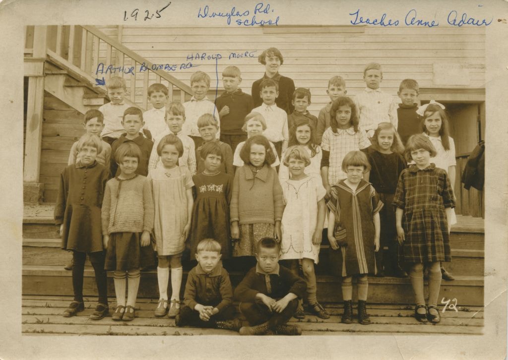
Students at Douglas Road School
https://search.heritageburnaby.ca/link/museumdescription78
- Repository
- Burnaby Village Museum
- Date
- 1925
- Collection/Fonds
- Burnaby Village Museum Photograph collection
- Description Level
- Item
- Physical Description
- 1 photograph : sepia ; 10.5 x 16 cm
- Scope and Content
- Photograph of students on the steps of Douglas Road School with their teacher, Annie Adair, standing in the centre at the very back. The boy standing on the extreme left at the back row is identified as Arthur Blomberg and the boy standing 4th from the left in the middle row is Harold Moore. The ot…
- Repository
- Burnaby Village Museum
- Collection/Fonds
- Burnaby Village Museum Photograph collection
- Description Level
- Item
- Physical Description
- 1 photograph : sepia ; 10.5 x 16 cm
- Scope and Content
- Photograph of students on the steps of Douglas Road School with their teacher, Annie Adair, standing in the centre at the very back. The boy standing on the extreme left at the back row is identified as Arthur Blomberg and the boy standing 4th from the left in the middle row is Harold Moore. The other students are not identified.
- Subjects
- Occupations - Teachers
- Geographic Access
- Canada Way
- Street Address
- 4861 Canada Way
- Accession Code
- BV989.28.1
- Access Restriction
- No restrictions
- Date
- 1925
- Media Type
- Photograph
- Historic Neighbourhood
- Burnaby Lake (Historic Neighbourhood)
- Planning Study Area
- Douglas-Gilpin Area
- Scan Resolution
- 600
- Scan Date
- 01-Jun-09
- Scale
- 100
- Notes
- Title based on contents of photograph
- Photographer identifies photograph as no. 42
- Notes on recto of photograph read: "Douglas Rd. school / Teacher Anne Adair / ARTHUR BLOMBERG / HAROLD MOORE" and "1925"
Images

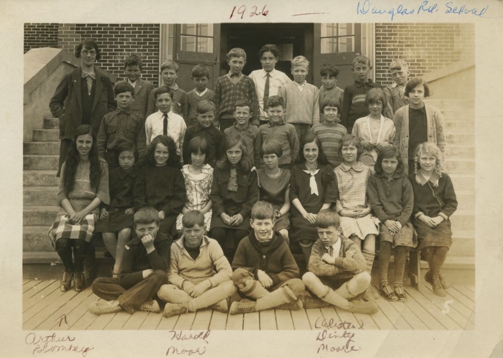
Students at Douglas Road School
https://search.heritageburnaby.ca/link/museumdescription79
- Repository
- Burnaby Village Museum
- Date
- 1926
- Collection/Fonds
- Burnaby Village Museum Photograph collection
- Description Level
- Item
- Physical Description
- 1 photograph : b&w ; 10.5 x 15.5 cm
- Scope and Content
- Photograph of students sitting and standing on the steps of Douglas Road School with their teacher (wearing glasses and an overcoat) on the far left at the back. In the front row, Arthur Blomberg is sitting on the far left, next to him is Harold Moore, with William A. "Dinty" Moore on the far right…
- Repository
- Burnaby Village Museum
- Collection/Fonds
- Burnaby Village Museum Photograph collection
- Description Level
- Item
- Physical Description
- 1 photograph : b&w ; 10.5 x 15.5 cm
- Scope and Content
- Photograph of students sitting and standing on the steps of Douglas Road School with their teacher (wearing glasses and an overcoat) on the far left at the back. In the front row, Arthur Blomberg is sitting on the far left, next to him is Harold Moore, with William A. "Dinty" Moore on the far right. The other students are not identified.
- Subjects
- Occupations - Teachers
- Geographic Access
- Canada Way
- Street Address
- 4861 Canada Way
- Accession Code
- BV989.28.2
- Access Restriction
- No restrictions
- Date
- 1926
- Media Type
- Photograph
- Historic Neighbourhood
- Burnaby Lake (Historic Neighbourhood)
- Planning Study Area
- Douglas-Gilpin Area
- Scan Resolution
- 600
- Scan Date
- 01-Jun-09
- Scale
- 100
- Notes
- Title based on contents of photograph
- Photographer identifies photograph as no. 5
- Notes on recto of photograph read: "Douglas Rd. School" and "1926 / Arthur Blomberg / Harold Moore / (Alister) Dinty Moore"
Images

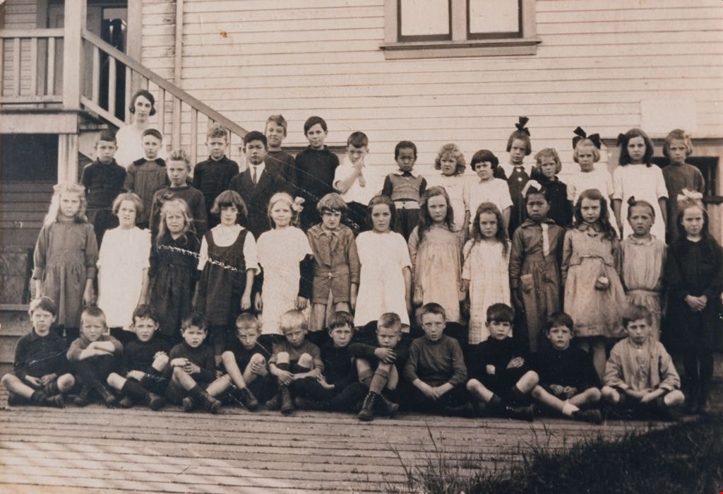
Students at Douglas Road School
https://search.heritageburnaby.ca/link/museumdescription1377
- Repository
- Burnaby Village Museum
- Date
- 1920
- Collection/Fonds
- Burnaby Village Museum Photograph collection
- Description Level
- Item
- Physical Description
- 1 photograph : sepia ; 17.5 x 25.5 cm print
- Scope and Content
- Photograph of Elsie Rummel (later McMurray) standing behind her students who are sitting and standing in rows outside Douglas Road school. Standing in the back two rows, left to right are; Jack Lort, Billy Mather, Teddy Norman (slightly in front), Ed Gavin, David Jung (slightly in front), Leonard R…
- Repository
- Burnaby Village Museum
- Collection/Fonds
- Burnaby Village Museum Photograph collection
- Description Level
- Item
- Physical Description
- 1 photograph : sepia ; 17.5 x 25.5 cm print
- Scope and Content
- Photograph of Elsie Rummel (later McMurray) standing behind her students who are sitting and standing in rows outside Douglas Road school. Standing in the back two rows, left to right are; Jack Lort, Billy Mather, Teddy Norman (slightly in front), Ed Gavin, David Jung (slightly in front), Leonard Rowley, Dave Banning, Herbert McConnell, Ying Jung, Gwendolyn Matthews, Avis Hart, Florence Cowan, Nancy Burnett, Winona Wood, Leona Smith, Sadie Bowie [or Dorothy Marsden]. Standing in the middle row are; Nora Rowley, Eva Dunnell [or Donnel], Rena Blomberg (later Ostby), Audrey [or Helen] Pontifex, Ruth Cole, Anna Matthews, Agnes Angus, Rhoda Gavin, Ruby Boucher, King Jung, Mary Lee, Frances "Fanny" Waplington (later Fleming), Beryl Hatch. Seated in the front row are; John Burnett [or Freddy Bogardus], John Waplington, Billy Townley, Roddie Saunders, Clive Cunningham, Ken Blott, Carl Banning, Doug Tyre, Bert Dawkins, Montague "Monty" Moore, John Moore and Alistair Westcott.
- Subjects
- Occupations - Teachers
- Names
- Douglas Road School
- McMurray, Elsie Rummel
- Lort, Jack
- Mather, Billy
- Norman, Teddy
- Gavin, Ed
- Jung, David
- Rowley, Leonard
- Banning, Dave
- McConnell, Herbert
- Jung, Suey Ying "Laura"
- Matthews, Gwendolyn
- Hart, Avis
- Cowan, Florence
- Burnett, Nancy
- Wood, Winona
- Smith, Leona
- Rowley, Nora
- Ostby, Rena Blomberg
- Cole, Ruth
- Matthews, Anna
- Angus, Agnes
- Gavin, Rhoda
- Boucher, Ruby
- Jung, King
- Lee, Mary
- Fleming, Frances "Fanny" Waplington
- Hatch, Beryl
- Waplington, John
- Townley, Billy
- Saunders, Roddie
- Cunningham, Clive
- Blott, Ken
- Banning, Carl
- Tyre, Doug
- Dawkins, Bert
- Moore, Montague Hutchings "Monty"
- Moore, John Gifford
- Westcott, Alistair
- Geographic Access
- Canada Way
- Street Address
- 4861 Canada Way
- Accession Code
- BV999.4.1
- Access Restriction
- No restrictions
- Reproduction Restriction
- No known restrictions
- Date
- 1920
- Media Type
- Photograph
- Historic Neighbourhood
- Burnaby Lake (Historic Neighbourhood)
- Planning Study Area
- Douglas-Gilpin Area
- Scan Resolution
- 600
- Scan Date
- 08-Jun-09
- Scale
- 100
- Notes
- Title based on contents of photograph
Images
![Subdivision plans in New Westminster District Group 1 – Burnaby
, [1893-1910] thumbnail](/media/hpo/_Data/_BVM_Cartographic_Material/1977/1977_0093_0016a_001.jpg?width=280)
Subdivision plans in New Westminster District Group 1 – Burnaby
https://search.heritageburnaby.ca/link/museumdescription6985
- Repository
- Burnaby Village Museum
- Date
- [1893-1910]
- Collection/Fonds
- Burnaby Village Museum Map collection
- Description Level
- File
- Physical Description
- 4 plans : blueprint ink on paper mounted on 2 sides of cardboard 76 x 102 cm
- Scope and Content
- Item consists of a large board of two New Westminster District Gp 1 - subdivision plans mounted on one side and two New Westminster District Gp 1 - subdivision plans mounted on the other side. Side A: 1. Blueprint "Plan / of Subdivision / of / Lot 6 / Group One / New Westminster District / Scale…
- Repository
- Burnaby Village Museum
- Collection/Fonds
- Burnaby Village Museum Map collection
- Description Level
- File
- Physical Description
- 4 plans : blueprint ink on paper mounted on 2 sides of cardboard 76 x 102 cm
- Material Details
- Scales [between 1:1584 and 1:3960]
- Index number on edge of board reads: "16"
- Scope and Content
- Item consists of a large board of two New Westminster District Gp 1 - subdivision plans mounted on one side and two New Westminster District Gp 1 - subdivision plans mounted on the other side. Side A: 1. Blueprint "Plan / of Subdivision / of / Lot 6 / Group One / New Westminster District / Scale 5 chs = 1 in. / Map No 748" (Geographic location: Burnaby) 2. Blueprint "Plan / of Subdivision / of a Portion / of / Lot 29 / Group One / New Westminster Dist. / Scale 2 chs = 1 in. / Map No." Name identified in Block H is "Reichenbach" (Geographic location: Burnaby) Side B: 1. Blueprint "Plan / of Subdivision / of North 1/2 of Lot 80 / Group One / New Westminster District / Scale 3 chs = 1 in. / Map No 719" Plan is signed by: "Garden, Hermon & Burwell P.L.S. / Vancouver Jan. 23rd, 1893" (Geographic location: Burnaby) 2. Blueprint "Plan / of Subdivision / of Lot 79, Gr.1 / New Westminster Dist. / Scale 4 chas = 1 in. / Map No 536" Plan is signed by "Garden Hermon & Burwell / Provincial Land Surveyors". (Geographic location: Burnaby)
- Creator
- Garden, Hermon and Burwell
- Accession Code
- HV977.93.16
- Access Restriction
- No restrictions
- Reproduction Restriction
- No known restrictions
- Date
- [1893-1910]
- Media Type
- Cartographic Material
- Historic Neighbourhood
- Edmonds (Historic Neighbourhood)
- Burnaby Lake (Historic Neighbourhood)
- Planning Study Area
- Douglas-Gilpin Area
- Edmonds Area
- Cameron Area
- Scan Resolution
- 300
- Scale
- 72
- Notes
- Title based on contents of file
- Scale is measured in chains. (One chain equals 792 inches)
- The term "Lot" can also refer to a "District Lot”
Images
![Subdivision plans in New Westminster District Group 1 – Burnaby
, [1893-1910] thumbnail](/media/hpo/_Data/_BVM_Cartographic_Material/1977/1977_0093_0016a_001.jpg)

![Survey and Subdivision plans in New Westminster District Group 1 and Group 2 – Vancouver, ʷməθkʷəy̓əm (Musqueam) Indian Reserve, Burnaby, Surrey
, [1910-1911] thumbnail](/media/hpo/_Data/_BVM_Cartographic_Material/1977/1977_0093_0017_001.jpg?width=280)
Survey and Subdivision plans in New Westminster District Group 1 and Group 2 – Vancouver, ʷməθkʷəy̓əm (Musqueam) Indian Reserve, Burnaby, Surrey
https://search.heritageburnaby.ca/link/museumdescription6986
- Repository
- Burnaby Village Museum
- Date
- [1910-1911]
- Collection/Fonds
- Burnaby Village Museum Map collection
- Description Level
- File
- Physical Description
- 9 plans : 4 plans : blueprint ink on paper + 4 plans : black ink on paper + 1 plan : graphite on paper mounted on 2 sides of cardboard 76 x 102 cm
- Scope and Content
- File consists of a large board of three survey plans in New Westminster District Group 1 mounted on one side and six survey and subdivision plans of District Lot 85, New Westminster District Group 1 mounted on the other side. Side A: 1. Plan : blueprint on paper ; 30.5 x 80 cm. Title reads: "Fras…
- Repository
- Burnaby Village Museum
- Collection/Fonds
- Burnaby Village Museum Map collection
- Description Level
- File
- Physical Description
- 9 plans : 4 plans : blueprint ink on paper + 4 plans : black ink on paper + 1 plan : graphite on paper mounted on 2 sides of cardboard 76 x 102 cm
- Material Details
- Scales vary (One chain equals 792 inches)
- Indexed number on tape on edge of board reads "17"
- Scope and Content
- File consists of a large board of three survey plans in New Westminster District Group 1 mounted on one side and six survey and subdivision plans of District Lot 85, New Westminster District Group 1 mounted on the other side. Side A: 1. Plan : blueprint on paper ; 30.5 x 80 cm. Title reads: "Fraser River Bridge / Plan of South Approach". Plan covers area of land north of the Fraser River and Great Northern Railway with approach for a bridge running through the "ʷməθkʷəy̓əm (Musqueam) Indian Reserve" (ʷməθkʷəy̓əm (Musqueam) First Nation) and lots marked as Dominion Government and the east half of Lot 2 identified as "C. F. Brown" "Plan 851". Plan is identified as "Plan 851 / traced / Mar. 17, 1911". (Geographic location in Vancouver) Scale: 100 feet = 1 inch, Signed by Albert J. Hill / P.L.S." 2. Plan : blueprint on paper ; 36.5 x 35 cm (no title). Includes three plans of lots on the east and west sides of North Road. Note on bottom of blueprint reads: "I.E.B. McKay Surveyor General - hereby certify / that this is a correct tracing from the field / notes of the Royal Engineers on file in the / Lands Department / E.B. McKay (signature) / Surveyor General / Victoria B.C. April 11th 1911" . Plan in top left titled "Page 11 / Vol. 1. / R.E. Notes" covers District Lots east of North Road including Lot 5, Lot 7, Lot 41, Lot 9 and Lot 107 in Coquitlam. Plan in top right corner titled "Page 17 / Vol. 1. / R.E. Notes" covers District Lots east of North Road including Lot 104, Lot 54, Lot 105, Lot 55, Lot 106, Lot 9 and Lot 107 in Coquitlam and Port Moody. Plan in lower left corner titled "Page 15 / Vol. 1 / R.E. Notes" covers District Lots west of North Road including Lot 147, Lot 148, Lot 100, Lot 15 in Burnaby. 3. Plan : blue print on paper ; 29.5 x 41.5 cm. (no formal title). Plan of the North 1/2 of Section 18. Plan covers area in the "North 1/2 of Sec.18 B.5 N RGE 1 W" and "Sec. 18 B.5 N. RGE 1 W" bordered by Section 7, Section 13, Section 17 and Section 19. Bon Accord Road runs through Sec. 18. The plan is signed by surveryor "I.H. Neville Smith... C.E.B.C.L.S. / Mar. 26th 1910" and signed by "Ludwig Pillath". (Geographic location: Surrey) Side B: 1. Plan : blueprint on paper ; 43.5 x 49.5 cm. Title reads: "Plan / of Subdivision / of a Portion / of / Lot 85 / Group One / New Westminster District. Plan covers portion of land east of Deer Lake and Pole Line Road (Sperling Avenue) and south of Hastings Road in District Lot 85 in Burnaby with section 4 and a portion of section 2 coloured in red. Plan is signed by "Albert J. Hill, B.C.L.S." Plan is initialed by: "RB" [sic] (in blue pencil crayon) Scale: 4 chains = 1 inch 2. Plaln : black black ink on linen ; 39 x 37 cm. Title reads: "L.C. Hill's Property, / Burnaby". Plan covers a triangular portion of land east of Pole Line Road (Sperling Avenue) and south of Hastings Road in District Lot 85 in Burnaby. Plan is intitaled by "RB" [sic] (in blue pencil crayon). Scale: 3 chains = 1 mile 3. Plan : graphite on paper ; 23 x 17 cm. Title reads: "Portion of Lot 85 / Gr.1". Plan covers portion of land north east of Deer Lake and west of Pole Line Road (now Sperling Avenue) in District Lot 85 in Burnaby. Plan is stamped in red ink: "Albert J. Hill, Civil Engineer". Plan is initialed by: "RB" [sic] (in blue pencil crayon). Scale: 1 chain = 1 inch 4. Plan : black ink on linen ; 16 x 19 cm. Title reads: "Lot 85". Plan covers the intersection of Pole Line Road (Sperling Avenue) and Hastings Road at the north west section of District Lot 79 and District Lot 85 in Burnaby. Plan is stamped: "A.J. Hill, Civil Engineer" with identitifed in blue pencil crayon. 5. Plan : black ink on paper ; 28.5 x 37 cm. (no formal title) Plan covers an area of land, west of Pole Line Road (Sperling Avenue) and south of Deer Lake in District Lot 85 in Burnaby. Plan is initialed by: "RB" [sic] (in blue pencil crayon) 6. Plan : black ink on paper ; 21 x 34 cm (no formal title). Plan covers an area of land, west of Pole Line Road (Sperling Avenue) and south of Deer Lake in District Lot 85 in Burnaby. Plan is initialed by: "RB" [sic] (in blue pencil crayon)
- Accession Code
- HV977.93.17
- Access Restriction
- No restrictions
- Reproduction Restriction
- No known restrictions
- Date
- [1910-1911]
- Media Type
- Cartographic Material
- Historic Neighbourhood
- Burnaby Lake (Historic Neighbourhood)
- Burquitlam (Historic Neighbourhood)
- Planning Study Area
- Morley-Buckingham Area
- Douglas-Gilpin Area
- Scan Resolution
- 600
- Scan Date
- 2023-06-26
- Notes
- Title based on contents of file
- Scale is measured in chains and feet. (One chain equals 792 inches).
- The term "Lot" also refers to a "District Lot”
- Some plans are stamped: "Albert J. Hill, Civil Engineer / and / Provincial Land Surveyor, / New Westminster, / B.C." and intialed: "RB" [sic]
Zoomable Images
![Survey and Subdivision plans in New Westminster District Group 1 and Group 2 – Vancouver, ʷməθkʷəy̓əm (Musqueam) Indian Reserve, Burnaby, Surrey
, [1910-1911] thumbnail](/media/hpo/_Data/_BVM_Cartographic_Material/1977/1977_0093_0017_003_seadragon/1977_0093_0017_003.jpg?w=280)
Survey and Subdivision plans in New Westminster District Group 1 and Group 2 – Vancouver, ʷməθkʷəy̓əm (Musqueam) Indian Reserve, Burnaby, Surrey , [1910-1911]
Zoom into Image
Tennis court
https://search.heritageburnaby.ca/link/archivedescription39217
- Repository
- City of Burnaby Archives
- Date
- 1926
- Collection/Fonds
- Peers Family and Hill Family fonds
- Description Level
- Item
- Physical Description
- 1 photograph : b&w ; 6 x 10.5 cm on page 24.5 x 32.5 cm (pasted in album)
- Scope and Content
- Photograph of the tennis court at the home of Kitty and Bob Peers on Deer Lake Avenue. The people in the photograph are unidentified.
- Repository
- City of Burnaby Archives
- Date
- 1926
- Collection/Fonds
- Peers Family and Hill Family fonds
- Physical Description
- 1 photograph : b&w ; 6 x 10.5 cm on page 24.5 x 32.5 cm (pasted in album)
- Description Level
- Item
- Record No.
- 477-536
- Access Restriction
- No restrictions
- Reproduction Restriction
- No known restrictions
- Accession Number
- 2007-12
- Scope and Content
- Photograph of the tennis court at the home of Kitty and Bob Peers on Deer Lake Avenue. The people in the photograph are unidentified.
- Subjects
- Sports - Tennis
- Media Type
- Photograph
- Notes
- Title based on caption accompanying photograph
- Geographic Access
- Deer Lake Avenue
- Street Address
- 6588 Deer Lake Avenue
- Historic Neighbourhood
- Burnaby Lake (Historic Neighbourhood)
- Planning Study Area
- Douglas-Gilpin Area
Images

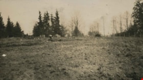
The Tennis Courts Under Construction
https://search.heritageburnaby.ca/link/archivedescription39219
- Repository
- City of Burnaby Archives
- Date
- 1923
- Collection/Fonds
- Peers Family and Hill Family fonds
- Description Level
- Item
- Physical Description
- 1 photograph : b&w ; 6 x 10.8 cm on page 24.5 x 32.5 cm (pasted in album)
- Scope and Content
- Photograph shows the land clearing undertaken in preparation for the construction of tennis courts at the home of Bob and Kitty Peers family on Deer Lake Avenue.
- Repository
- City of Burnaby Archives
- Date
- 1923
- Collection/Fonds
- Peers Family and Hill Family fonds
- Physical Description
- 1 photograph : b&w ; 6 x 10.8 cm on page 24.5 x 32.5 cm (pasted in album)
- Description Level
- Item
- Record No.
- 477-538
- Access Restriction
- No restrictions
- Reproduction Restriction
- No known restrictions
- Accession Number
- 2007-12
- Scope and Content
- Photograph shows the land clearing undertaken in preparation for the construction of tennis courts at the home of Bob and Kitty Peers family on Deer Lake Avenue.
- Subjects
- Land Clearing
- Media Type
- Photograph
- Notes
- Title based on caption accompanying photograph
- Geographic Access
- Deer Lake Avenue
- Street Address
- 6588 Deer Lake Avenue
- Historic Neighbourhood
- Burnaby Lake (Historic Neighbourhood)
- Planning Study Area
- Douglas-Gilpin Area
Images

![Townley Mansion, Deerholme, [1913] (date of original), copied 2003 thumbnail](/media/hpo/_Data/_Archives_Images/_Unrestricted/371/454-001.jpg?width=280)
Townley Mansion, Deerholme
https://search.heritageburnaby.ca/link/archivedescription38529
- Repository
- City of Burnaby Archives
- Date
- [1913] (date of original), copied 2003
- Collection/Fonds
- Burnaby Historical Society fonds
- Description Level
- Item
- Physical Description
- 1 photograph : b&w ; 20.5 x 25.5 cm print
- Scope and Content
- Photograph of the Thomas O. and Frances Townley mansion known as Deerholme built in 1913 at Deer Lake by Vancouver's pioneer and 1901 Mayor, Colonel Thomas Owen Townley, and his wife Frances. The home was designed by their son Fred Laughton Townley, who had just returned from the University of Penn…
- Repository
- City of Burnaby Archives
- Date
- [1913] (date of original), copied 2003
- Collection/Fonds
- Burnaby Historical Society fonds
- Subseries
- Municipal record subseries
- Physical Description
- 1 photograph : b&w ; 20.5 x 25.5 cm print
- Description Level
- Item
- Record No.
- 454-001
- Access Restriction
- No restrictions
- Reproduction Restriction
- No known restrictions
- Accession Number
- BHS2003-9
- Scope and Content
- Photograph of the Thomas O. and Frances Townley mansion known as Deerholme built in 1913 at Deer Lake by Vancouver's pioneer and 1901 Mayor, Colonel Thomas Owen Townley, and his wife Frances. The home was designed by their son Fred Laughton Townley, who had just returned from the University of Pennsylvania where he had received a degree in architecture. The Townley's enjoyed their estate until 1920 when they rented the house to the Cunningham family before selling the property to the Vancouver Anglican College.The college held the building until 1940, when it was again sold and was owned by various owners who came and went. Finally, the Loftus family sold the property to the City of Burnaby in 1979. The house remains leased as a private residence and was dedicated as a civic heritage site in 1992.
- Media Type
- Photograph
- Notes
- Title based on contents of photograph
- Geographic Access
- Price Street
- Street Address
- 6110 Price Street
- Historic Neighbourhood
- Burnaby Lake (Historic Neighbourhood)
- Planning Study Area
- Douglas-Gilpin Area
Images
![Townley Mansion, Deerholme, [1913] (date of original), copied 2003 thumbnail](/media/hpo/_Data/_Archives_Images/_Unrestricted/371/454-001.jpg)
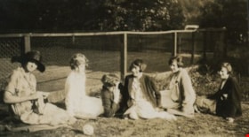
Women seated next to a tennis court
https://search.heritageburnaby.ca/link/archivedescription39218
- Repository
- City of Burnaby Archives
- Date
- 1926
- Collection/Fonds
- Peers Family and Hill Family fonds
- Description Level
- Item
- Physical Description
- 1 photograph : sepia ; 6 x 11 cm on page 24.5 x 32.5 cm (pasted in album)
- Scope and Content
- Photograph of six women seated next to the tennis court at the home of Bob and Kitty Peers family on Deer Lake Avenue. All are unidentified.
- Repository
- City of Burnaby Archives
- Date
- 1926
- Collection/Fonds
- Peers Family and Hill Family fonds
- Physical Description
- 1 photograph : sepia ; 6 x 11 cm on page 24.5 x 32.5 cm (pasted in album)
- Description Level
- Item
- Record No.
- 477-537
- Access Restriction
- No restrictions
- Reproduction Restriction
- No known restrictions
- Accession Number
- 2007-12
- Scope and Content
- Photograph of six women seated next to the tennis court at the home of Bob and Kitty Peers family on Deer Lake Avenue. All are unidentified.
- Subjects
- Sports - Tennis
- Media Type
- Photograph
- Notes
- Title based on caption accompanying photograph
- Geographic Access
- Deer Lake Avenue
- Street Address
- 6588 Deer Lake Avenue
- Historic Neighbourhood
- Burnaby Lake (Historic Neighbourhood)
- Planning Study Area
- Douglas-Gilpin Area
Images
