Narrow Results By
Decade
- 2020s 96
- 2010s 242
- 2000s 352
- 1990s 515
- 1980s 488
- 1970s 568
- 1960s 638
- 1950s 774
- 1940s 1039
- 1930s 1345
- 1920s 1276
- 1910s
- 1900s 456
- 1890s 185
- 1880s 175
- 1870s 74
- 1860s 127
- 1850s 18
- 1840s 4
- 1830s 2
- 1820s 2
- 1810s 4
- 1800s 3
- 1790s 3
- 1780s 3
- 1770s 3
- 1760s 3
- 1750s 3
- 1740s 3
- 1730s 3
- 1720s 3
- 1710s 3
- 1700s 3
- 1690s 3
- 1680s 3
- 1670s 2
- 1660s 2
- 1650s 2
- 1640s 2
- 1630s 2
- 1620s 2
- 1610s 2
- 1600s 2
- 1590s
- 1580s 1
- 1570s 1
- 1560s 1
- 1550s 1
- 1540s 1
- 1530s 1
- 1520s 1
- 1510s 1
- 1500s 1
- 1490s 1
- 1480s 1
Hart, Hill and Peers families
https://search.heritageburnaby.ca/link/archivedescription35917
- Repository
- City of Burnaby Archives
- Date
- 1915 (date of original), copied 1986
- Collection/Fonds
- Burnaby Historical Society fonds
- Description Level
- Item
- Physical Description
- 1 photograph : b&w ; 12.7 x 17.8 cm print
- Scope and Content
- Photograph of the Hart, Hill and Peers families, including Kingsley Hart, who was later killed in the First World War. The photograph was taken at 6664 Deer Lake Avenue.
- Repository
- City of Burnaby Archives
- Date
- 1915 (date of original), copied 1986
- Collection/Fonds
- Burnaby Historical Society fonds
- Subseries
- Pioneer Tales subseries
- Physical Description
- 1 photograph : b&w ; 12.7 x 17.8 cm print
- Description Level
- Item
- Record No.
- 204-776
- Access Restriction
- No restrictions
- Reproduction Restriction
- No known restrictions
- Accession Number
- BHS1988-03
- Scope and Content
- Photograph of the Hart, Hill and Peers families, including Kingsley Hart, who was later killed in the First World War. The photograph was taken at 6664 Deer Lake Avenue.
- Media Type
- Photograph
- Notes
- Title based on contents of photograph
- Geographic Access
- Deer Lake Avenue
- Street Address
- 6664 Deer Lake Avenue
- Historic Neighbourhood
- Burnaby Lake (Historic Neighbourhood)
- Planning Study Area
- Morley-Buckingham Area
Images

![Love and Stanley families at Pitt Lake, [191-] thumbnail](/media/hpo/_Data/_BVM_Images/2022/2022_0032_0076_001.jpg?width=280)
Love and Stanley families at Pitt Lake
https://search.heritageburnaby.ca/link/museumdescription19654
- Repository
- Burnaby Village Museum
- Date
- [191-]
- Collection/Fonds
- Esther Love Stanley fonds
- Description Level
- Item
- Physical Description
- 1 photograph : b&w ; 8 x 11 cm
- Scope and Content
- Photograph of members of the Love and Stanley families together at Pitt Lake. Family members are gathered together on a steep rocky shore while two men are standing on the bow of a boat. The boat and a canoe are tied to the shore with ropes.
- Repository
- Burnaby Village Museum
- Collection/Fonds
- Esther Love Stanley fonds
- Description Level
- Item
- Physical Description
- 1 photograph : b&w ; 8 x 11 cm
- Scope and Content
- Photograph of members of the Love and Stanley families together at Pitt Lake. Family members are gathered together on a steep rocky shore while two men are standing on the bow of a boat. The boat and a canoe are tied to the shore with ropes.
- Subjects
- Geographic Features - Lakes and Ponds
- Transportation - Boats
- Recreational Activities - Boating
- Recreational Activities - Canoeing
- Names
- Love Family
- Accession Code
- BV022.32.76
- Access Restriction
- No restrictions
- Reproduction Restriction
- No known restrictions
- Date
- [191-]
- Media Type
- Photograph
- Scan Resolution
- 600
- Scan Date
- 2023-04-04
- Notes
- Title based on contents of photograph
- Photograph is part of Esther Love Stanley photograph album 1 (BV022.32.1)
Images
![Love and Stanley families at Pitt Lake, [191-] thumbnail](/media/hpo/_Data/_BVM_Images/2022/2022_0032_0076_001.jpg)
![Love and Whiting families picnicing under tent, [c. 1910] thumbnail](/media/hpo/_Data/_BVM_Images/2022/2022_0032_0029_001.jpg?width=280)
Love and Whiting families picnicing under tent
https://search.heritageburnaby.ca/link/museumdescription19312
- Repository
- Burnaby Village Museum
- Date
- [c. 1910]
- Collection/Fonds
- Esther Love Stanley fonds
- Description Level
- Item
- Physical Description
- 1 photograph : b&w ; 8.5 x 11 cm
- Scope and Content
- Photograph of members of the Love and Whiting families gathered together for a meal under a canvas tent. The group is gathered around a long table that is in the middle of the tent. Annie Elizabeth (Love) Whiting is identified as the woman who is holding a young child in her lap, seated at the end …
- Repository
- Burnaby Village Museum
- Collection/Fonds
- Esther Love Stanley fonds
- Description Level
- Item
- Physical Description
- 1 photograph : b&w ; 8.5 x 11 cm
- Material Details
- Photograph is over exposed, washing out some of the detail
- Scope and Content
- Photograph of members of the Love and Whiting families gathered together for a meal under a canvas tent. The group is gathered around a long table that is in the middle of the tent. Annie Elizabeth (Love) Whiting is identified as the woman who is holding a young child in her lap, seated at the end of the table closest to the stove. A wood stove with pots and a kettle is visible in the foreground. The location is identified as Boundary Bay.
- Accession Code
- BV022.32.29
- Access Restriction
- No restrictions
- Reproduction Restriction
- No known restrictions
- Date
- [c. 1910]
- Media Type
- Photograph
- Scan Resolution
- 600
- Scan Date
- 2023-04-04
- Notes
- Title based on contents of photograph
- Photograph is part of Esther Love Stanley photograph album 1 (BV022.32.1)
- Note in white ink on album page reads: "BOUNDARY BAY?"
Images
![Love and Whiting families picnicing under tent, [c. 1910] thumbnail](/media/hpo/_Data/_BVM_Images/2022/2022_0032_0029_001.jpg)

McClean and Hawkshaw families
https://search.heritageburnaby.ca/link/museumdescription2813
- Repository
- Burnaby Village Museum
- Date
- 1917
- Collection/Fonds
- Hawkshaw family fonds
- Description Level
- Item
- Physical Description
- 1 photograph : sepia ; 7.5 x 11 cm, mounted to card ; 10 x 15 cm
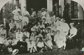
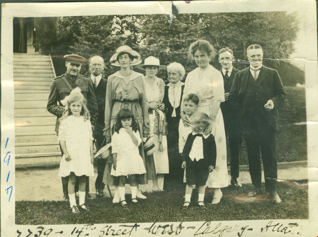
- Scope and Content
- Photograph of the McClean and Hawkshaw families standing outside 2239 14th Street West, Calgary Alberta. James Edward "Jack" Hawkshaw is standing in the front row on the far right. His wife is on his right, holding the shoulders of their two eldest children, Crichton and Dal Hawkshaw. The other ind…
- Repository
- Burnaby Village Museum
- Collection/Fonds
- Hawkshaw family fonds
- Description Level
- Item
- Physical Description
- 1 photograph : sepia ; 7.5 x 11 cm, mounted to card ; 10 x 15 cm
- Scope and Content
- Photograph of the McClean and Hawkshaw families standing outside 2239 14th Street West, Calgary Alberta. James Edward "Jack" Hawkshaw is standing in the front row on the far right. His wife is on his right, holding the shoulders of their two eldest children, Crichton and Dal Hawkshaw. The other individuals in the photograph have been identified only as the McClean family.
- Names
- Hawkshaw, Richard Crichton Gilliland "Crichton"
- Hawkshaw, Edward Delamere Burrington "Dal"
- Hawkshaw, John Edward "Jack"
- Hawkshaw, Mabel Edith Honor McClean
- Accession Code
- BV996.6.287
- Access Restriction
- No restrictions
- Reproduction Restriction
- No known restrictions
- Date
- 1917
- Media Type
- Photograph
- Scan Resolution
- 600
- Scan Date
- 2024-05-07
- Notes
- Title based on contents of photograph
- Note on recto of photograph reads: "1917 / 2239 - 14th Street West - Calgary - [illegible]"
Images
McClean and Hawkshaw families
https://search.heritageburnaby.ca/link/museumdescription2817
- Repository
- Burnaby Village Museum
- Date
- 1918
- Collection/Fonds
- Hawkshaw family fonds
- Description Level
- Item
- Physical Description
- 1 photograph : sepia ; 8 x 13 cm
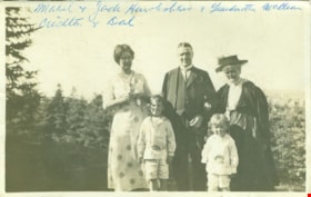
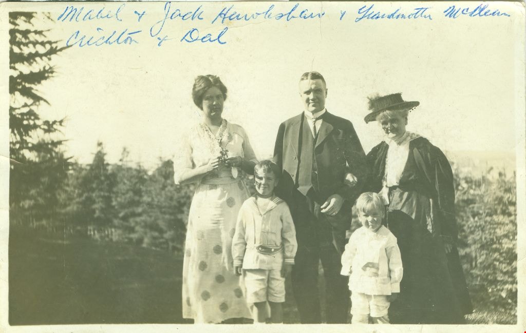
- Scope and Content
- Photograph of the Hawkshaw and McClean families. Standing in the back row (from left) are; Mabel and John Edward "Jack" Hawkshaw with Mabel’s mother, Mrs. Honor (Delamore) McClean. In the front row are Mabel and Jack’s two eldest sons, Crichton and Dal Hawkshaw.
- Repository
- Burnaby Village Museum
- Collection/Fonds
- Hawkshaw family fonds
- Description Level
- Item
- Physical Description
- 1 photograph : sepia ; 8 x 13 cm
- Scope and Content
- Photograph of the Hawkshaw and McClean families. Standing in the back row (from left) are; Mabel and John Edward "Jack" Hawkshaw with Mabel’s mother, Mrs. Honor (Delamore) McClean. In the front row are Mabel and Jack’s two eldest sons, Crichton and Dal Hawkshaw.
- Names
- Hawkshaw, Mabel Edith Honor McClean
- Hawkshaw, John Edward "Jack"
- Hawkshaw, Richard Crichton Gilliland "Crichton"
- Hawkshaw, Edward Delamere Burrington "Dal"
- McClean, Honor Delamore
- Accession Code
- BV996.6.292
- Access Restriction
- No restrictions
- Reproduction Restriction
- No known restrictions
- Date
- 1918
- Media Type
- Photograph
- Scan Resolution
- 600
- Scan Date
- 2024-05-14
- Notes
- Title based on contents of photograph
- Note on recto of photograph reads: “Mabel + Jack Hawkshaw + Grandmother McClean / Crichton + Dal”
- Duplicate cropped photograph accompanying
Images
![Members of Love and Stanley families at Pitt Lake, [191-] thumbnail](/media/hpo/_Data/_BVM_Images/2022/2022_0032_0115_001.jpg?width=280)
Members of Love and Stanley families at Pitt Lake
https://search.heritageburnaby.ca/link/museumdescription19693
- Repository
- Burnaby Village Museum
- Date
- [191-]
- Collection/Fonds
- Esther Love Stanley fonds
- Description Level
- Item
- Physical Description
- 1 photograph : b&w ; 8 x 10.5 cm
- Scope and Content
- Photograph of male members of the Love and Stanley families at Pitt Lake. Four men are standing on the shore, one man is standing on the bow of a boat and two men are paddling a canoe.
- Repository
- Burnaby Village Museum
- Collection/Fonds
- Esther Love Stanley fonds
- Description Level
- Item
- Physical Description
- 1 photograph : b&w ; 8 x 10.5 cm
- Scope and Content
- Photograph of male members of the Love and Stanley families at Pitt Lake. Four men are standing on the shore, one man is standing on the bow of a boat and two men are paddling a canoe.
- Subjects
- Transportation - Boats
- Names
- Love Family
- Accession Code
- BV022.32.115
- Access Restriction
- No restrictions
- Reproduction Restriction
- No known restrictions
- Date
- [191-]
- Media Type
- Photograph
- Scan Resolution
- 600
- Scan Date
- 2023-04-04
- Notes
- Title based on contents of photograph
- Photograph is part of Esther Love Stanley photograph album 1 (BV022.32.1)
Images
![Members of Love and Stanley families at Pitt Lake, [191-] thumbnail](/media/hpo/_Data/_BVM_Images/2022/2022_0032_0115_001.jpg)
![Members of the Love and Whiting families, [191-] thumbnail](/media/hpo/_Data/_BVM_Images/2022/2022_0032_0213_001.jpg?width=280)
Members of the Love and Whiting families
https://search.heritageburnaby.ca/link/museumdescription19791
- Repository
- Burnaby Village Museum
- Date
- [191-]
- Collection/Fonds
- Esther Love Stanley fonds
- Description Level
- Item
- Physical Description
- 1 photograph : b&w ; 8.5 x 10.5 cm
- Scope and Content
- Photograph of members of the Love and Whiting families gathered together in a clearing surrounded by trees and bushes. People standing are identified L to R as; Esther Love Stanley, Martha "Dot" (Love) Brandrith, George Love, Thomas Robert "Bob" Love and Annie (Love) Whiting. The two young girls se…
- Repository
- Burnaby Village Museum
- Collection/Fonds
- Esther Love Stanley fonds
- Description Level
- Item
- Physical Description
- 1 photograph : b&w ; 8.5 x 10.5 cm
- Scope and Content
- Photograph of members of the Love and Whiting families gathered together in a clearing surrounded by trees and bushes. People standing are identified L to R as; Esther Love Stanley, Martha "Dot" (Love) Brandrith, George Love, Thomas Robert "Bob" Love and Annie (Love) Whiting. The two young girls seated on the ground are identified as Hannah "Girlie" (Love) Barnes and Edith Whiting. Two young boys are seated on the ground to the left. The women are wearing blouses and long skirts, the men are wearing shirts and ties, Bob Love is wearing a cap and both Dot and Edith are wearing hats. Edith Whiting has her hair done in pig tails with ribbons and is holding a baby on her lap.
- Names
- Love Family
- Stanley, Esther Love
- Brandrith, Martha Dorothy “Dot” Love
- Love, George Richard
- Love, Thomas "Bob" Robert
- Whiting, Annie Elizabeth Love
- Barnes, Hannah Victoria "Girlie" Love
- Clayton, Edith Annie Whiting
- Whiting Family
- Accession Code
- BV022.32.213
- Access Restriction
- No restrictions
- Reproduction Restriction
- No known restrictions
- Date
- [191-]
- Media Type
- Photograph
- Related Material
- City of Burnaby Archives - see ID: 204-594
- See also BV022.32.126
- Scan Resolution
- 600
- Scan Date
- 2023-04-18
- Notes
- Title based on contents of photograph
- Photograph is part of Esther Love Stanley photograph album 1 (BV022.32.1)
- Sticker adhered to top of photograph reads: "Sefl, Dot, George, Bob, Annie/ Girlie, Edith & boys.
Images
![Members of the Love and Whiting families, [191-] thumbnail](/media/hpo/_Data/_BVM_Images/2022/2022_0032_0213_001.jpg)
![Members of the Love and Whiting families with fish, [191-] thumbnail](/media/hpo/_Data/_BVM_Images/2022/2022_0032_0301_001.jpg?width=280)
Members of the Love and Whiting families with fish
https://search.heritageburnaby.ca/link/museumdescription19879
- Repository
- Burnaby Village Museum
- Date
- [191-]
- Collection/Fonds
- Esther Love Stanley fonds
- Description Level
- Item
- Physical Description
- 1 photograph : b&w ; 8 x 10.5 cm
- Scope and Content
- Photograph of members of the Love and Whiting families fishing and camping at Boundary Bay. Adults and children are standing together in a line and posing with their catch of fish. Smaller fish are hanging from a stick and three women are holding larger fish. People identified include; Esther Love …
- Repository
- Burnaby Village Museum
- Collection/Fonds
- Esther Love Stanley fonds
- Description Level
- Item
- Physical Description
- 1 photograph : b&w ; 8 x 10.5 cm
- Scope and Content
- Photograph of members of the Love and Whiting families fishing and camping at Boundary Bay. Adults and children are standing together in a line and posing with their catch of fish. Smaller fish are hanging from a stick and three women are holding larger fish. People identified include; Esther Love Stanley (far right), Martha "Dot" (Love) Brandrith (third from right), Annie Whiting (second from left) and Edith Whiting (far left). Man standing in the group is identified as Wallace "Flash" Whiting. The group is standing in a clearing in the woods and their is a canvas tent stretched behind trees behind the group.
- Names
- Stanley, Esther Love
- Brandrith, Martha Dorothy “Dot” Love
- Whiting, Annie Elizabeth Love
- Clayton, Edith Annie Whiting
- Whiting Family
- Love Family
- Whiting, Wallace "Flash"
- Accession Code
- BV022.32.301
- Access Restriction
- No restrictions
- Reproduction Restriction
- No known restrictions
- Date
- [191-]
- Media Type
- Photograph
- Related Material
- See also BV022.32.317
- Scan Resolution
- 600
- Scan Date
- 2023-05-09
- Notes
- Title based on contents of photograph
- Photograph is part of Esther Love Stanley photograph album 1 (BV022.32.1)
Images
![Members of the Love and Whiting families with fish, [191-] thumbnail](/media/hpo/_Data/_BVM_Images/2022/2022_0032_0301_001.jpg)
Studies in the scriptures : series 1 : the plan of the ages : a vindication of the divine character and government: showing, by a recognition and harmonizing of all the scriptures, that the permission of evil, past and present, is educational and preparatory to the userhing of mankind into the golden age of prophecy in which all the families of the earth will be blessed with a full knowledge of God and a full opportunity for attaining everlasing life through the redeemer, who then will be the great restorer and life-giver.
https://search.heritageburnaby.ca/link/museumlibrary3697
- Repository
- Burnaby Village Museum
- Collection
- Special Collection
- Material Type
- Book
- Accession Code
- BV001.1.32
- Call Number
- 230.9 WAT
- Place of Publication
- London
- Publisher
- Watch Tower Bible & Tract Society
- Publication Date
- 1910
- c1886
- Physical Description
- 356, 14 p. : 1 folded chart ; 19 cm.
- Library Subject (LOC)
- Jehovah's Witnesses
- Bible
- Notes
- Includes "A criticism of millennial hopes examined"
- Includes index.
Temporary Assistance to Families
https://search.heritageburnaby.ca/link/councilreport74368
- Repository
- City of Burnaby Archives
- Report ID
- 80526
- Meeting Date
- 30-Dec-1912
- Format
- Council - Committee Report
- Collection/Fonds
- City Council and Office of the City Clerk fonds
- Repository
- City of Burnaby Archives
- Report ID
- 80526
- Meeting Date
- 30-Dec-1912
- Format
- Council - Committee Report
- Collection/Fonds
- City Council and Office of the City Clerk fonds
Documents
Waplington and Fleming families album series
https://search.heritageburnaby.ca/link/museumdescription18958
- Repository
- Burnaby Village Museum
- Date
- [1900-2004]
- Collection/Fonds
- Waplington family fonds
- Description Level
- Series
- Physical Description
- 1 album (88 photographs, textual records, graphic material)
- Scope and Content
- Series consists of an album about the Waplington and Fleming families. The album contains photographs, family documents, stories, poems, biographies and genealogy about family members.
- Repository
- Burnaby Village Museum
- Collection/Fonds
- Waplington family fonds
- Description Level
- Series
- Physical Description
- 1 album (88 photographs, textual records, graphic material)
- Scope and Content
- Series consists of an album about the Waplington and Fleming families. The album contains photographs, family documents, stories, poems, biographies and genealogy about family members.
- Date
- [1900-2004]
- Media Type
- Photograph
- Textual Record
- Graphic Material
- Notes
- Title based on contents of series
![Warren and Pearson families, [191-] (date of original), copied 1986 thumbnail](/media/hpo/_Data/_Archives_Images/_Unrestricted/204/204-398.jpg?width=280)
Warren and Pearson families
https://search.heritageburnaby.ca/link/archivedescription35540
- Repository
- City of Burnaby Archives
- Date
- [191-] (date of original), copied 1986
- Collection/Fonds
- Burnaby Historical Society fonds
- Description Level
- Item
- Physical Description
- 1 photograph : b&w ; 12.7 x 17.8 cm print
- Scope and Content
- Photograph of (left to right) Mrs. Mary Warren (mother of James, Mary and Joan Warren), Joan "Agnes" Warren, Jack Pearson (neighbour), and Mrs. Harold Pearson (neighbour) in front of the Pearson home, across the street from the Warren home at 4264 Union Street. Harry Pearson, a mining man, ran the…
- Repository
- City of Burnaby Archives
- Date
- [191-] (date of original), copied 1986
- Collection/Fonds
- Burnaby Historical Society fonds
- Subseries
- Pioneer Tales subseries
- Physical Description
- 1 photograph : b&w ; 12.7 x 17.8 cm print
- Description Level
- Item
- Record No.
- 204-398
- Access Restriction
- No restrictions
- Reproduction Restriction
- No restrictions
- Accession Number
- BHS1988-03
- Scope and Content
- Photograph of (left to right) Mrs. Mary Warren (mother of James, Mary and Joan Warren), Joan "Agnes" Warren, Jack Pearson (neighbour), and Mrs. Harold Pearson (neighbour) in front of the Pearson home, across the street from the Warren home at 4264 Union Street. Harry Pearson, a mining man, ran the Orpheum Theatre in Vancouver for many years with Ted Summers and Ivan Ackery.
- Subjects
- Buildings - Residential - Houses
- Media Type
- Photograph
- Notes
- Title based on contents of photograph
- Geographic Access
- Union Street
- Street Address
- 4264 Union Street
- Historic Neighbourhood
- Vancouver Heights (Historic Neighbourhood)
- Planning Study Area
- Willingdon Heights Area
Images
![Warren and Pearson families, [191-] (date of original), copied 1986 thumbnail](/media/hpo/_Data/_Archives_Images/_Unrestricted/204/204-398.jpg)

F.J. Hart Estate 'Avalon'
https://search.heritageburnaby.ca/link/landmark542
- Repository
- Burnaby Heritage Planning
- Description
- The F.J. Hart Estate, 'Avalon,' is comprised of 5.26 hectares of lakefront property now located within Deer Lake Park, an Arts and Crafts/Tudor Revival styled mansion and an associated later outbuilding. The mansion is now operated as the Hart House Restaurant.
- Associated Dates
- 1912
- Formal Recognition
- Heritage Designation, Community Heritage Register
- Other Names
- Hart House, Rosedale Gardens, Frederick John & Alice Hart Estate
- Street View URL
- Google Maps Street View
- Repository
- Burnaby Heritage Planning
- Other Names
- Hart House, Rosedale Gardens, Frederick John & Alice Hart Estate
- Geographic Access
- Deer Lake Avenue
- Associated Dates
- 1912
- Formal Recognition
- Heritage Designation, Community Heritage Register
- Enactment Type
- Bylaw No. 9807
- Enactment Date
- 23/11/1992
- Description
- The F.J. Hart Estate, 'Avalon,' is comprised of 5.26 hectares of lakefront property now located within Deer Lake Park, an Arts and Crafts/Tudor Revival styled mansion and an associated later outbuilding. The mansion is now operated as the Hart House Restaurant.
- Heritage Value
- 'Avalon' and its estate grounds are important as an illustration of the cultural, aesthetic, and lifestyle values of the wealthy families that settled in the Deer Lake area early in the twentieth century. These values were predominantly those of elegant country living and leisure pursuits. The estate is important for its connection with wealthy land developer Frederick John Hart (1868-1945), who was not only instrumental in the creation of subdivisions which promoted Deer Lake as an exclusive residential development for successful families in the New Westminster and Vancouver area, but was also an influential member of this new suburban community and of the emerging municipality of Burnaby. Hart had a wide range of business, civic, and political interests: his real-estate company managed many of the land sales in the area and numerous other large developments throughout the region; he was an entrepreneurial businessman associated with a number of companies important to the economic development of the area and British Columbia; and he was a 'public spirited citizen' and an alderman for the City of New Westminster. The architectural style of ‘Avalon’ set the tone for many of the grand mansions in the adjacent residential development - British Arts and Crafts in derivation, with eclectic details, particularly Tudor precedents. Designed for Hart and his wife Alice Chapman Hart (1867-1935) by Burnaby architect Frank William Macey (1863-1935), the use of references to Tudor England illustrates the relevance and importance to the residents of the area of a strong and visible connection with Britain. The first resident architect in Burnaby, Macey was born and trained in England where he was well-respected for having published two standard texts for the architectural profession. He settled in Burnaby in the first decade of the twentieth century and obtained a number of commissions from prominent businessmen who were building grand homes in the new community of Deer Lake. He designed mostly in the British Arts and Crafts style and introduced the use of rough-cast stucco for building exteriors, a characteristic for which he was renowned, and of which ‘Avalon’ is an excellent example.
- Defining Elements
- Key elements that define the heritage character of 'Avalon' include its: - estate in its entirety: house, grounds, landscape features and garage outbuilding - complex asymmetrical massing - side gable roof punctuated with massive cross gables at the front and rear and open gable ends - exterior features of the house such as the rough-cast stucco with mock-Tudor timbering; cobble-stone facings; square tower with mock battlements - multiple-assemblies of wooden-sash casement windows - tall, prominent corbelled brick chimneys - grand interior spaces and fittings: particularly the entrance hall with its carved stone fireplace; the main staircase; panelled wainscotting; Tudor-arched windows; and fireplaces with original tile surrounds
- Locality
- Deer Lake Park
- Historic Neighbourhood
- Burnaby Lake (Historic Neighbourhood)
- Planning Study Area
- Morley-Buckingham Area
- Architect
- Frank William Macey
- Function
- Primary Current--Eating or Drinking Establishment
- Primary Historic--Estate
- Community
- Burnaby
- Cadastral Identifier
- P.I.D. No. 002-764-431 Legal Description: Lot 6 Except: Firstly: Part on Reference Plan 14874 and Secondly: Part subdivided by Plan 77594, District Lot 85, Group 1, New Westminster District, Plan 11109
- Boundaries
- 'Avalon' is comprised of a single municipally-owned property located at 6664 Deer Lake Avenue, Burnaby.
- Area
- 18,792.29
- Contributing Resource
- Building
- Landscape Feature
- Ownership
- Public (local)
- Other Collection
- Burnaby Village Museum, Collection: Hart Photograph Albums
- Documentation
- Heritage Site Files: PC77000 20. City of Burnaby Planning and Building Department, 4949 Canada Way, Burnaby, B.C., V5G 1M2
- Street Address
- 6664 Deer Lake Avenue
- Street View URL
- Google Maps Street View
Images


Broadview Neighbourhood
https://search.heritageburnaby.ca/link/landmark750
- Repository
- Burnaby Heritage Planning
- Associated Dates
- 1905-1924
- Heritage Value
- Between 1905 and 1924, the Broadview neighbourhood in Burnaby was settled by almost 100 families who saw the advantage of living in an area that was served by two railway lines - the B.C. Electric Railway and the Great Northern Railway. Touted as being only a 20 minute car ride to the city centre, this neighbourhood expanded during the early 1920s with the promise of a new direct access road to the city being built by the Great Northern Railway company and new blocks being opened up on two government reserves adjoining it.
- Historic Neighbourhood
- Broadview (Historic Neighbourhood)
- Planning Study Area
- Cascade-Schou Area
Images


H.T. Ceperley Estate 'Fairacres' Garage & Stables
https://search.heritageburnaby.ca/link/landmark530
- Repository
- Burnaby Heritage Planning
- Description
- Designed in the British Arts and Crafts style, the ‘Fairacres’ Garage and Stables is a two-storey wood frame building located on the 'Fairacres' estate, situated to the north of the Chauffeur's Cottage; at the south end of the structure is a single vehicle garage and to the north are several stable…
- Associated Dates
- 1911
- Formal Recognition
- Heritage Designation, Community Heritage Register
- Street View URL
- Google Maps Street View
- Repository
- Burnaby Heritage Planning
- Geographic Access
- Deer Lake Avenue
- Associated Dates
- 1911
- Formal Recognition
- Heritage Designation, Community Heritage Register
- Enactment Type
- Bylaw No. 9807
- Enactment Date
- 23/11/1992
- Description
- Designed in the British Arts and Crafts style, the ‘Fairacres’ Garage and Stables is a two-storey wood frame building located on the 'Fairacres' estate, situated to the north of the Chauffeur's Cottage; at the south end of the structure is a single vehicle garage and to the north are several stables for carriage, riding, and draught horses, a coach house, and tack room; the upper floor was originally a hay loft.
- Heritage Value
- The outbuildings at 'Fairacres' are a rare surviving architecturally designed ensemble of agricultural structures that exist in complementary harmony with the main estate house. Architect Robert Mackay Fripp (1858-1917) was retained by the Ceperleys to design several original outbuildings on their estate at the same time as the main house was constructed. The Garage and Stables building is important as a record of its era when transportation modes were in transition and the horse-drawn carriage, while still in use, was giving way to the automobile. The relative spatial arrangements within the building are a valuable indication of the economy of space associated with the automobile, as compared to the horse. The extent of the stabling arrangements signifies not only the use of carriage horses but also the continued reliance on draught horses in farming activities in this era. As well, it is an indication of the fashionable nature of equestrianism for wealthy families during this time. The building is important as a demonstration of the aesthetics of the Ceperley family in having an architect-designed outbuilding and obtaining craftsmanship and materials of the highest quality for each structure on their estate.
- Defining Elements
- Key elements that define the heritage character of the 'Fairacres' Garage and Stables include its: - location within easy reach of the main house and in close proximity to the Chauffeur's Cottage - floor plan with the garage at one end, close to the Chauffeur's Cottage, and stables and equine facilities at the other - variety and complexity of the roofline, including gable wall dormers, gable-on-hip roof ends, and half-hip extensions - Arts and Crafts architectural features of the exterior such as the shingle wall cladding articulated with a chevron-patterned course of shingles at the first floor level; casement windows; and deep eaves with additional purlins to support the overhang - original stable doors with hand-made forged-iron door hardware - multi-paned wooden-sash windows, some retaining original wire glass
- Locality
- Deer Lake Park
- Historic Neighbourhood
- Burnaby Lake (Historic Neighbourhood)
- Planning Study Area
- Douglas-Gilpin Area
- Architect
- Robert Mackay Fripp
- Function
- Primary Historic--Outbuilding
- Community
- Burnaby
- Cadastral Identifier
- P.I.D. No. 004-493-311 Legal Description: Block 3 Except: Part subdivided by Plan 26865, District Lot 79, Group 1, New Westminster District, Plan 536
- Boundaries
- ‘Fairacres’ is comprised of a single municipally-owned property located at 6344 Deer Lake Avenue, Burnaby.
- Area
- 17,065.00
- Contributing Resource
- Building
- Landscape Feature
- Ownership
- Public (local)
- Other Collection
- Burnaby Historical Society, Community Archives: Ceperley Photograph Album
- Documentation
- Heritage Site Files: PC77000 20. City of Burnaby Planning and Building Department, 4949 Canada Way, Burnaby, B.C., V5G 1M2
- Street Address
- 6344 Deer Lake Avenue
- Street View URL
- Google Maps Street View
Images


J.A. Thurston House 'Altese'
https://search.heritageburnaby.ca/link/landmark511
- Repository
- Burnaby Heritage Planning
- Description
- The J.A. Thurston House is a very large, two and one-half storey plus basement wood-frame Arts and Crafts style house. It is located on the south side of Thurston Street, near Kingsway and the SkyTrain (formerly the interurban tramline route), within the Metrotown area of Burnaby and is now part of…
- Associated Dates
- 1912
- Formal Recognition
- Heritage Designation, Community Heritage Register
- Other Names
- John A. & Sarah Thurston House
- Street View URL
- Google Maps Street View
- Repository
- Burnaby Heritage Planning
- Other Names
- John A. & Sarah Thurston House
- Geographic Access
- Thurston Street
- Associated Dates
- 1912
- Formal Recognition
- Heritage Designation, Community Heritage Register
- Enactment Type
- Bylaw No. 9934
- Enactment Date
- 09/08/1993
- Description
- The J.A. Thurston House is a very large, two and one-half storey plus basement wood-frame Arts and Crafts style house. It is located on the south side of Thurston Street, near Kingsway and the SkyTrain (formerly the interurban tramline route), within the Metrotown area of Burnaby and is now part of a large apartment complex.
- Heritage Value
- The J.A. Thurston House demonstrates Burnaby's real estate and construction boom along the interurban tramline in 1911. The house was built for John Albert Thurston (1874-1944) and his wife Sarah Sedona Thurston (1879-1961). Typical of the entrepreneurial spirit of the age, John Thurston, a manager for the Leckie Shoe Company Limited in Vancouver, was also involved in real estate development, and purchased a twenty-one lot subdivision consisting of 3.2 hectares bound by the interurban tramline right-of-way to the south, Boundary Road to the west and Smith Street (now Thurston Street) to the north. Additionally, the J.A. Thurston House is an excellent, high quality example of an Arts and Crafts style dwelling, with numerous notable design elements such as the battered piers, the elaborate second storey dormer and stained glass windows with landscape and seascape motifs. The enormous scale of the house reflects a time when large families were common and domestic servants were needed to run the household. Indicative of the labour-saving devices and luxury features being introduced at the high end of the housing market, it was equipped with a built-in vacuum system, refrigeration, servant summoning devices and a round safe built into a fireplace mantle. The J.A. Thurston House also represents the proliferation during the Edwardian era of homes built from pattern books and standardized designs as a means to expedite the construction process and offer competitive costs.
- Defining Elements
- Key elements that define the heritage character of the J.A. Thurston House include its: - location on Thurston Street, in the old Central Park district - residential form, scale and massing as exemplified by its two and one-half storey plus above-ground basement height and regular, rectangular plan - Arts and Crafts style details such as the picturesque roofline, deep open eaves with exposed purlins, narrow lapped wooden siding on the first storey and cedar shingle siding on the upper storeys - broad and unusually steep side gabled roof, clad with cedar shingles - deeply-recessed full open front verandah with complementary recessed balcony in second storey dormer, incorporating both a gabled roof and shed roof - twinned and triple square bracketed columns on the verandahs and balcony - decorative battered verandah piers, supported on exposed beams - irregular fenestration, including: double-hung wooden-sash windows; picture windows; casement windows; and several stained glass windows with landscape and seascape motifs - tall brick external chimney on east facade - original interior features such as fireplaces, and wooden trim and floors
- Historic Neighbourhood
- Central Park (Historic Neighbourhood)
- Planning Study Area
- Garden Village Area
- Function
- Primary Historic--Single Dwelling
- Primary Current--Single Dwelling
- Community
- Burnaby
- Cadastral Identifier
- 018-224-113
- Boundaries
- The J.A. Thurston House is comprised of a single residential lot located at 3762 Thurston Street, Burnaby.
- Area
- 3880
- Contributing Resource
- Building
- Ownership
- Private
- Street Address
- 3762 Thurston Street
- Street View URL
- Google Maps Street View
Images


J.D. Shearer House
https://search.heritageburnaby.ca/link/landmark513
- Repository
- Burnaby Heritage Planning
- Description
- The J.D. Shearer House is a one and one-half storey British Arts and Crafts-style house distinguished by its picturesque roofline, half-timbered rough-cast stucco cladding on the upper floor and battered window casings. It is located on the south side of Buckingham Avenue at Haszard Street in Burna…
- Associated Dates
- 1912
- Formal Recognition
- Heritage Designation, Community Heritage Register
- Other Names
- John D. & Katherine Shearer House
- Street View URL
- Google Maps Street View
- Repository
- Burnaby Heritage Planning
- Other Names
- John D. & Katherine Shearer House
- Geographic Access
- Buckingham Avenue
- Associated Dates
- 1912
- Formal Recognition
- Heritage Designation, Community Heritage Register
- Enactment Type
- Bylaw No. 10423
- Enactment Date
- 26/08/1996
- Description
- The J.D. Shearer House is a one and one-half storey British Arts and Crafts-style house distinguished by its picturesque roofline, half-timbered rough-cast stucco cladding on the upper floor and battered window casings. It is located on the south side of Buckingham Avenue at Haszard Street in Burnaby's Deer Lake neighbourhood.
- Heritage Value
- Built in 1912, the J.D. Shearer House is an excellent example of the high quality residences constructed in the British Arts and Crafts style by affluent citizens in Burnaby's Deer Lake neighbourhood, promoted at the time as the equivalent of the prestigious Shaughnessy Heights development in Vancouver. The site of this house was part of Louis Claude Hill's Buckingham Estate subdivision. Development of these Edwardian era neighbourhoods in Burnaby was facilitated by the B.C. Electric Railway interurban line. In addition, the increasing availability of automobiles to the well-to-do families of the era sped up the process of urbanization in the outlying areas of Vancouver. Built for retired English military officer John D. Shearer and his wife, Katherine, the British Arts and Crafts design of the house represents associations with the Mother Country and the displays of patriotic loyalty considered desirable characteristics at the time. The picturesque charm and character of rural England is evoked in harmony with its woodland setting.
- Defining Elements
- Key elements that define the heritage character of the J.D. Shearer House include its: - location in the Buckingham Estate subdivision in the Deer Lake neighbourhood - residential form, scale and massing as exemplified by its one and one-half storey plus basement height, asymmetrical plan, front bay window and picturesque roofline - British Arts and Crafts details such as the half-timbering and rough-cast stucco on the upper storey, battered window casings, external clinker brick chimney on the east facade, deep overhanging closed eaves and bargeboards with distinctive lower returns - side gabled roof with gabled and shed dormers, clad in cedar - raised central entrance porch - irregular fenestration, including multi-paned transoms over casement windows - two internal red brick chimneys
- Historic Neighbourhood
- Burnaby Lake (Historic Neighbourhood)
- Planning Study Area
- Morley-Buckingham Area
- Function
- Primary Historic--Single Dwelling
- Primary Current--Single Dwelling
- Community
- Burnaby
- Cadastral Identifier
- 023-316-977
- Boundaries
- The J.D. Shearer House is comprised of a single residential lot located at 5573 Buckingham Avenue, Burnaby.
- Area
- 1044
- Contributing Resource
- Building
- Ownership
- Private
- Street Address
- 5573 Buckingham Avenue
- Street View URL
- Google Maps Street View
Images


William Wilson House
https://search.heritageburnaby.ca/link/landmark512
- Repository
- Burnaby Heritage Planning
- Description
- The William Wilson House is a vernacular two-storey wood-frame Foursquare house with a hipped roof. It is situated at the corner of Wilson Avenue and Central Boulevard in the Metrotown area of Burnaby, adjacent to the SkyTrain line, and is now part of a multi-family residential complex.
- Associated Dates
- 1913
- Formal Recognition
- Heritage Designation, Community Heritage Register
- Other Names
- William & Annie Wilson House
- Street View URL
- Google Maps Street View
- Repository
- Burnaby Heritage Planning
- Other Names
- William & Annie Wilson House
- Geographic Access
- Wilson Avenue
- Associated Dates
- 1913
- Formal Recognition
- Heritage Designation, Community Heritage Register
- Enactment Type
- Bylaw No. 10350
- Enactment Date
- 22/04/1996
- Description
- The William Wilson House is a vernacular two-storey wood-frame Foursquare house with a hipped roof. It is situated at the corner of Wilson Avenue and Central Boulevard in the Metrotown area of Burnaby, adjacent to the SkyTrain line, and is now part of a multi-family residential complex.
- Heritage Value
- The house is valued as the residence of William Wilson (1860-1935) and Annie Wilson (1868-1966) and demonstrates the development of Burnaby from a rural, farming community to an early commuter suburb, and is one of the few remaining early houses in the Metrotown area of Burnaby. Reflecting the area's early history, it was constructed on a subdivided piece of the Wilson’s 3.2 hectare farm that once bordered Kingsway, the primary road linking New Westminster to Vancouver. To develop his subdivided property, Wilson constructed a bisecting street, named it for himself and situated his new home on a large parcel adjacent to the interurban tramline. Constructed in 1913, the William Wilson House is additionally valued as a modest vernacular example of an Edwardian era Foursquare house. Although simple in form, it is distinguished by an inset front verandah, front bay window and clipped ground level corner. Once commonly found in Burnaby, this is a rare surviving example of the homes typically constructed for the working-class families enticed to Burnaby as a consequence of the interurban tramline.
- Defining Elements
- Key elements that define the heritage character of William Wilson House include its: - corner location, adjacent to the old interurban alignment - vernacular Foursquare style as exemplified by its symmetrical form, square floor plan and cubic massing with pyramidal roof - cladding, with narrow lapped wooden siding on the first storey and cedar shingles on the second storey - recessed front verandah, with square columns and ground floor cut-away bay window - regular fenestration, including double-hung 1-over-1 wooden-sash windows, and casement and transom assembly feature window in the living room
- Historic Neighbourhood
- Central Park (Historic Neighbourhood)
- Planning Study Area
- Maywood Area
- Function
- Primary Historic--Single Dwelling
- Primary Current--Single Dwelling
- Community
- Burnaby
- Cadastral Identifier
- 023-352-701
- Boundaries
- The William Wilson House is comprised of a single residential lot located at 6088 Wilson Avenue, Burnaby.
- Area
- 2824.9
- Contributing Resource
- Building
- Ownership
- Private
- Street Address
- 6088 Wilson Avenue
- Street View URL
- Google Maps Street View
Images


D.C. Patterson House
https://search.heritageburnaby.ca/link/landmark517
- Repository
- Burnaby Heritage Planning
- Description
- The D.C. Patterson House is a one and one-half storey plus basement wood-frame Edwardian era residence with a full-width front verandah and symmetrical saddlebag dormers. It is located adjacent to a ravine park and is part of the Winston Gate development.
- Associated Dates
- 1910
- Formal Recognition
- Heritage Designation, Community Heritage Register
- Other Names
- Dugald & Frances Patterson House
- Street View URL
- Google Maps Street View
- Repository
- Burnaby Heritage Planning
- Other Names
- Dugald & Frances Patterson House
- Geographic Access
- 12th Avenue
- Associated Dates
- 1910
- Formal Recognition
- Heritage Designation, Community Heritage Register
- Enactment Type
- Bylaw No. 10062
- Enactment Date
- 11/07/1994
- Description
- The D.C. Patterson House is a one and one-half storey plus basement wood-frame Edwardian era residence with a full-width front verandah and symmetrical saddlebag dormers. It is located adjacent to a ravine park and is part of the Winston Gate development.
- Heritage Value
- This house is significant for its associations with the Patterson family, who were early Burnaby pioneers. Dugald Campbell Patterson (1860-1931) and Frances Mabel Patterson (1872-1960) arrived in 1894 and settled in the Central Park district. In 1910, they relocated to the Edmonds District and built this family residence on Edmonds Street near Kingsway. The Pattersons were community minded citizens who served Burnaby through their involvement with local municipal affairs and politics. Dugald Patterson served as a School Trustee in 1912-13 and was one of the first residents to lobby council to preserve the local ravines as parks. The family name is remembered and honoured by the naming of Patterson Avenue and the Patterson SkyTrain Station located in the Metrotown area. Additionally, the D.C. Patterson House is significant as a fine example of a vernacular Edwardian era family house. The typical design of the Patterson House was taken from an Edwardian era pattern book, and demonstrates how standardized plans were commonly used by local owners and builders to expedite the construction process. This house has survived in an excellent state of preservation. Although moved from its original site, it remains as an intact representation of a middle-class Burnaby residence of the Edwardian era.
- Defining Elements
- Key elements that define the heritage character of the D.C. Patterson House include its: - vernacular residential form, scale and massing as exemplified by its one and one-half storey plus basement height, front gabled roof with hipped return over front verandah, symmetrical saddlebag dormers and rectangular, side hall plan with an asymmetrical front entry - typical Edwardian era construction features such as the deep boxed eaves, lapped wooden siding and cedar shingle roofing - projecting front gable peak, clad in decorative random-coursed square shingles, with eave brackets under and a louvered attic vent - projecting elements on the main floor including a square bay on the east side and a semi-octagonal bay to the west side - full-width open front verandah with irregularly-spaced square columns - closed balustrades with drainage scuppers on the front verandah and rear side porch - regular fenestration, including double hung 1-over-1 wooden-sash windows with proportionately smaller upper sash, triple assembly of windows in the front gable, and leaded glass in main floor front window - original front door with inset bevelled glass light
- Historic Neighbourhood
- Edmonds (Historic Neighbourhood)
- Planning Study Area
- Stride Hill Area
- Function
- Primary Historic--Single Dwelling
- Primary Current--Single Dwelling
- Community
- Burnaby
- Cadastral Identifier
- 003-008-321
- Boundaries
- The D.C. Patterson House is comprised of a single residential lot located at 7106 Eighteenth Avenue, Burnaby.
- Area
- 5176
- Contributing Resource
- Building
- Ownership
- Private
- Street Address
- 7106 18th Avenue
- Street View URL
- Google Maps Street View
Images


R.F. Anderson House
https://search.heritageburnaby.ca/link/landmark531
- Repository
- Burnaby Heritage Planning
- Description
- The R.F. Anderson House is a large, two-and-one-half storey Arts and Crafts style wood frame house, now located in Deer Lake Park, built as a family home and now used as institutional offices.
- Associated Dates
- 1912
- Formal Recognition
- Heritage Designation, Community Heritage Register
- Other Names
- Robert Fenwick & Bessie Anderson House, Anderson Residence
- Street View URL
- Google Maps Street View
- Repository
- Burnaby Heritage Planning
- Other Names
- Robert Fenwick & Bessie Anderson House, Anderson Residence
- Geographic Access
- Deer Lake Avenue
- Associated Dates
- 1912
- Formal Recognition
- Heritage Designation, Community Heritage Register
- Enactment Type
- Bylaw No. 9807
- Enactment Date
- 23/11/1992
- Description
- The R.F. Anderson House is a large, two-and-one-half storey Arts and Crafts style wood frame house, now located in Deer Lake Park, built as a family home and now used as institutional offices.
- Heritage Value
- The R.F. Anderson House contributes to the overall stylistic ambiance of the area and demonstrates that a range of architectural features can be read as a cohesive whole. Although designed primarily in the British Arts and Crafts genre, as were other residences around Deer Lake, it also displays some influences of the popular Craftsman style. It was constructed in the Deer Lake Crescent subdivision, which was originally promoted as an upper class neighbourhood. It represents one of the first residential developments in the City of Burnaby that required buildings to be of a specific value, thus demonstrating the desire for exclusivity among the successful businessmen who chose to settle in the area. The house and grounds illustrate the social, cultural, lifestyle and leisure sensibilities of a successful local businessman and his family in the early twentieth century; Anderson was a New Westminster hardware merchant and Justice of the Peace. The development of the house and grounds within a controlled suburban context also illustrate the values of the owners in the Deer Lake Crescent subdivision, such as social aspiration, racial exclusivity, demonstration of architectural taste, importance of a landscaped garden, and the provision of facilities for fashionable leisure pursuits such as lawn tennis. The estate makes an important contribution to the residential grouping now preserved within Deer Lake Park, and demonstrates the broad social mix of those who chose to live in the area at a time when it was in transition from a market gardening area to a more exclusive residential community. The R.F. Anderson House is important for its association with local architect Frank William Macey (1863-1935), the first resident architect in Burnaby. Macey was born and trained in England where he was well-respected for having published two standard texts for the architectural profession. He settled in Burnaby in the first decade of the twentieth century and obtained a number of commissions from prominent businessmen who were building grand homes in the new community of Deer Lake. He designed these houses mostly in the British Arts and Crafts style.
- Defining Elements
- Key elements that define the heritage character of the R.F. Anderson House include its: - location within a park setting in relation to the W.J. Mathers House - irregular massing of the exterior and its cladding of drop-siding, with half-timbering and rough-cast stucco in the gables - picturesque irregular roofline, including an alteration in pitch over the front verandah, with cedar shingle cladding - interior plan with its generous entrance hall, staircase, and massive staircase window with leaded-lights - multiple-assembly wooden-sash casement windows - quality of interior features such as the Douglas Fir woodwork (some with original varnish finish); original hardware supplied by Anderson's hardware company; and original fireplaces with ornate tile surrounds - setting with the imprint of the lawn tennis court, now a garden terrace, and some of the original plantings
- Locality
- Deer Lake Park
- Historic Neighbourhood
- Burnaby Lake (Historic Neighbourhood)
- Planning Study Area
- Douglas-Gilpin Area
- Architect
- Frank William Macey
- Function
- Primary Current--Government Office
- Primary Historic--Single Dwelling
- Community
- Burnaby
- Cadastral Identifier
- P.I.D. No. 007-525-931 Legal Description: North 225 feet Lot 'C', District Lot 79, Group 1, New Westminster District, Plan 6884
- Boundaries
- The R.F. Anderson House is comprised of a single municipally-owned property located at 6450 Deer Lake Avenue, Burnaby.
- Area
- 63,100.00
- Contributing Resource
- Building
- Landscape Feature
- Ownership
- Public (local)
- Documentation
- Heritage Site Files: PC77000 20. City of Burnaby Planning and Building Department, 4949 Canada Way, Burnaby, B.C., V5G 1M2
- Names
- Macey, Frank W.
- Street Address
- 6450 Deer Lake Avenue
- Street View URL
- Google Maps Street View
Images


