Narrow Results By
Subject
- Agriculture - Farms 7
- Animals - Cows 3
- Animals - Dogs 1
- Animals - Horses 4
- Animals - Poultry 1
- Buildings - Agricultural - Barns 4
- Buildings - Agricultural - Stables 1
- Buildings - Civic - City Halls 1
- Buildings - Religious - Churches 2
- Buildings - Residential - Houses 8
- Buildings - Residential - Townhouses 1
- Ceremonial Artifacts - Flags 1
Person / Organization
- Blair, William A. 1
- Burnaby City Hall 1
- Burnaby Lake Riding Academy 5
- Burnaby Lake Saddle Club 5
- Clark, Warren R. 1
- Constable, Thomas W. "Tom" 1
- Drummond, John D. "Doug" 1
- Elizabeth II Queen of Great Britain, 1926-2022 2
- Gordon, Merrill 1
- Hill, Bernard R 1
- Hill, Minard Gerald "Gerry" 1
- Lawson, Doreen A. 1

Barn at Lubbock's farm
https://search.heritageburnaby.ca/link/archivedescription36520
- Repository
- City of Burnaby Archives
- Date
- 1977
- Collection/Fonds
- Burnaby Historical Society fonds
- Description Level
- Item
- Physical Description
- 1 photograph : col. ; 9 x 8.5 cm
- Scope and Content
- Photograph of the horse barn at Lubbock's farm. Both the Burnaby Lake Riding Academy and the Burnaby Lake Saddle Club operated out of the Lubbock farm.
- Repository
- City of Burnaby Archives
- Date
- 1977
- Collection/Fonds
- Burnaby Historical Society fonds
- Subseries
- Lubbock family subseries
- Physical Description
- 1 photograph : col. ; 9 x 8.5 cm
- Description Level
- Item
- Record No.
- 289-009
- Access Restriction
- No restrictions
- Reproduction Restriction
- Reproduce for fair dealing purposes only
- Accession Number
- BHS1992-24
- Scope and Content
- Photograph of the horse barn at Lubbock's farm. Both the Burnaby Lake Riding Academy and the Burnaby Lake Saddle Club operated out of the Lubbock farm.
- Subjects
- Buildings - Agricultural - Barns
- Media Type
- Photograph
- Notes
- Title based on contents of photograph
- Geographic Access
- Grandview Highway
- Canada Way
- Burris Street
- Street Address
- 7803 Burris Street
- Historic Neighbourhood
- Burnaby Lake (Historic Neighbourhood)
- Planning Study Area
- Morley-Buckingham Area
Images

![Burnaby Council, [1973] thumbnail](/media/hpo/_Data/_Archives_Images/_Unrestricted/204/204-804.jpg?width=280)
Burnaby Council
https://search.heritageburnaby.ca/link/archivedescription35944
- Repository
- City of Burnaby Archives
- Date
- [1973]
- Collection/Fonds
- Burnaby Historical Society fonds
- Description Level
- Item
- Physical Description
- 1 photograph : col. ; 12.7 x 17.8 cm
- Scope and Content
- Photograph of the Burnaby Council in chambers. The council members have nameplates in front of them.
- Repository
- City of Burnaby Archives
- Date
- [1973]
- Collection/Fonds
- Burnaby Historical Society fonds
- Subseries
- Pioneer Tales subseries
- Physical Description
- 1 photograph : col. ; 12.7 x 17.8 cm
- Description Level
- Item
- Record No.
- 204-804
- Access Restriction
- No restrictions
- Reproduction Restriction
- Reproduce for fair dealing purposes only
- Accession Number
- BHS1988-03
- Scope and Content
- Photograph of the Burnaby Council in chambers. The council members have nameplates in front of them.
- Subjects
- Officials - Alderman and Councillors
- Buildings - Civic - City Halls
- Officials - Mayors and Reeves
- Government - Local Government
- Names
- Blair, William A.
- Clark, Warren R.
- Constable, Thomas W. "Tom"
- Drummond, John D. "Doug"
- Gordon, Merrill
- Lawson, Doreen A.
- McLean, George H.F.
- Mercier, James L "Jim"
- Prittie, Robert W. "Bob"
- Burnaby City Hall
- Media Type
- Photograph
- Photographer
- Croton Studio Limited
- Notes
- Title based on contents of photograph
- Geographic Access
- Canada Way
- Street Address
- 4949 Canada Way
- Historic Neighbourhood
- Burnaby Lake (Historic Neighbourhood)
- Planning Study Area
- Douglas-Gilpin Area
Images
![Burnaby Council, [1973] thumbnail](/media/hpo/_Data/_Archives_Images/_Unrestricted/204/204-804.jpg)

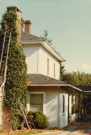
Burnett home
https://search.heritageburnaby.ca/link/archivedescription37371
- Repository
- City of Burnaby Archives
- Date
- 1974
- Collection/Fonds
- Burnaby Historical Society fonds
- Description Level
- Item
- Physical Description
- 1 photograph : col. ; 9 x 12.8 cm
- Scope and Content
- Photograph of the home of Mr. Burnett (old street number 6561 Canada Way).
- Repository
- City of Burnaby Archives
- Date
- 1974
- Collection/Fonds
- Burnaby Historical Society fonds
- Subseries
- Photographs subseries
- Physical Description
- 1 photograph : col. ; 9 x 12.8 cm
- Description Level
- Item
- Record No.
- 365-002
- Access Restriction
- No restrictions
- Reproduction Restriction
- Reproduce for fair dealing purposes only
- Accession Number
- BHS2007-04
- Scope and Content
- Photograph of the home of Mr. Burnett (old street number 6561 Canada Way).
- Subjects
- Buildings - Residential - Houses
- Media Type
- Photograph
- Notes
- Title based on caption
- Geographic Access
- Canada Way
- Planning Study Area
- Lakeview-Mayfield Area
Images

![Canadian Flag raising, [196-] thumbnail](/media/hpo/_Data/_Archives_Images/_Unrestricted/316/366-040-4.jpg?width=280)
Canadian Flag raising
https://search.heritageburnaby.ca/link/archivedescription97625
- Repository
- City of Burnaby Archives
- Date
- [196-]
- Collection/Fonds
- Burnaby Historical Society fonds
- Description Level
- File
- Physical Description
- 6 photographs : b&w negatives
- Scope and Content
- Photographs of a Canadian flag raising ceremony at Burnaby Municipal Hall.
- Repository
- City of Burnaby Archives
- Date
- [196-]
- Collection/Fonds
- Burnaby Historical Society fonds
- Subseries
- Municipal record subseries
- Physical Description
- 6 photographs : b&w negatives
- Description Level
- File
- Record No.
- 366-040
- Access Restriction
- No restrictions
- Reproduction Restriction
- Reproduce for fair dealing purposes only
- Accession Number
- BHS1998-12
- Scope and Content
- Photographs of a Canadian flag raising ceremony at Burnaby Municipal Hall.
- Subjects
- Ceremonial Artifacts - Flags
- Media Type
- Photograph
- Notes
- Title based on content of photographs
- Geographic Access
- Canada Way
- Street Address
- 4949 Canada Way
- Historic Neighbourhood
- Vancouver Heights (Historic Neighbourhood)
- Planning Study Area
- Burnaby Heights Area
Images
![Canadian Flag raising, [196-] thumbnail](/media/hpo/_Data/_Archives_Images/_Unrestricted/316/366-040-4.jpg)

Cattle at Canada Way
https://search.heritageburnaby.ca/link/archivedescription36524
- Repository
- City of Burnaby Archives
- Date
- 1977
- Collection/Fonds
- Burnaby Historical Society fonds
- Description Level
- Item
- Physical Description
- 1 photograph : col. ; 9 x 8.5 cm
- Scope and Content
- Photograph of cattle grazing on the grass, taken from Burris Street, looking towards Canada Way.
- Repository
- City of Burnaby Archives
- Date
- 1977
- Collection/Fonds
- Burnaby Historical Society fonds
- Subseries
- Lubbock family subseries
- Physical Description
- 1 photograph : col. ; 9 x 8.5 cm
- Description Level
- Item
- Record No.
- 289-013
- Access Restriction
- No restrictions
- Reproduction Restriction
- Reproduce for fair dealing purposes only
- Accession Number
- BHS1992-24
- Scope and Content
- Photograph of cattle grazing on the grass, taken from Burris Street, looking towards Canada Way.
- Subjects
- Animals - Cows
- Media Type
- Photograph
- Notes
- Title based on contents of photograph
- Geographic Access
- Canada Way
- Burris Street
- Historic Neighbourhood
- Burnaby Lake (Historic Neighbourhood)
- Planning Study Area
- Morley-Buckingham Area
Images


Chicken at Lubbock's farm
https://search.heritageburnaby.ca/link/archivedescription36522
- Repository
- City of Burnaby Archives
- Date
- 1977
- Collection/Fonds
- Burnaby Historical Society fonds
- Description Level
- Item
- Physical Description
- 1 photograph : col. ; 9 x 8.5 cm
- Scope and Content
- Photograph of chickens inside a tall fence at the Lubbock farm. The barn is visible in the background.
- Repository
- City of Burnaby Archives
- Date
- 1977
- Collection/Fonds
- Burnaby Historical Society fonds
- Subseries
- Lubbock family subseries
- Physical Description
- 1 photograph : col. ; 9 x 8.5 cm
- Description Level
- Item
- Record No.
- 289-011
- Access Restriction
- No restrictions
- Reproduction Restriction
- Reproduce for fair dealing purposes only
- Accession Number
- BHS1992-24
- Scope and Content
- Photograph of chickens inside a tall fence at the Lubbock farm. The barn is visible in the background.
- Subjects
- Animals - Poultry
- Agriculture - Farms
- Media Type
- Photograph
- Notes
- Title based on contents of photograph
- Geographic Access
- Grandview Highway
- Canada Way
- Burris Street
- Street Address
- 7803 Burris Street
- Historic Neighbourhood
- Burnaby Lake (Historic Neighbourhood)
- Planning Study Area
- Morley-Buckingham Area
Images


Crowd gathered for Queen Elizabeth II
https://search.heritageburnaby.ca/link/archivedescription38362
- Repository
- City of Burnaby Archives
- Date
- 1971
- Collection/Fonds
- Burnaby Historical Society fonds
- Description Level
- Item
- Physical Description
- 1 photograph : col. ; 10 x 15 cm
- Scope and Content
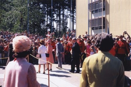
- Photograph of a large crowd gathered behind a line of Royal Canadian Mounted Police officers, with Queen Elizabeth II visible in the centre. This photograph was taken during the 1971 visit of Queen Elizabeth II and Prince Philip to Burnaby.
- Repository
- City of Burnaby Archives
- Date
- 1971
- Collection/Fonds
- Burnaby Historical Society fonds
- Subseries
- Photographs subseries
- Physical Description
- 1 photograph : col. ; 10 x 15 cm
- Description Level
- Item
- Record No.
- 417-005
- Access Restriction
- No restrictions
- Reproduction Restriction
- Reproduce for fair dealing purposes only
- Accession Number
- BHS2001-7
- Scope and Content
- Photograph of a large crowd gathered behind a line of Royal Canadian Mounted Police officers, with Queen Elizabeth II visible in the centre. This photograph was taken during the 1971 visit of Queen Elizabeth II and Prince Philip to Burnaby.
- Media Type
- Photograph
- Notes
- Title based on contents of photograph
- Geographic Access
- Canada Way
- Street Address
- 4949 Canada Way
- Historic Neighbourhood
- Burnaby Lake (Historic Neighbourhood)
- Planning Study Area
- Douglas-Gilpin Area
Images
Deer Lake office complex under construction
https://search.heritageburnaby.ca/link/archivedescription36109
- Repository
- City of Burnaby Archives
- Date
- September 7, 1977
- Collection/Fonds
- Burnaby Historical Society fonds
- Description Level
- Item
- Physical Description
- 1 photograph : b&w ; 15.5 x 24.5 cm
- Scope and Content
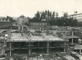
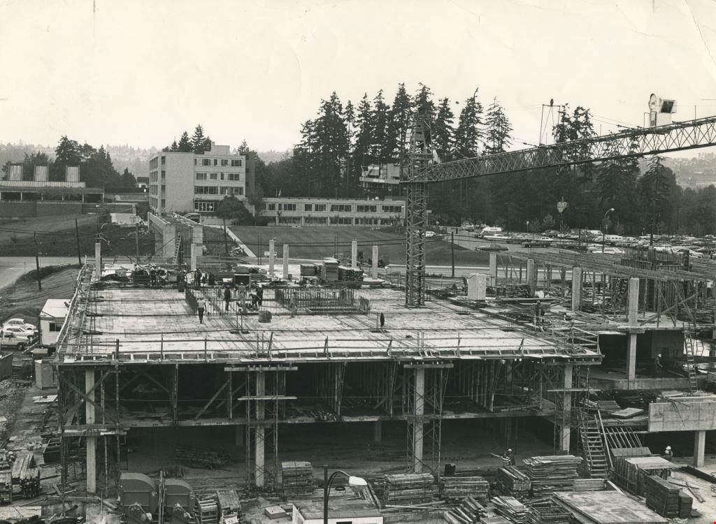
- Photograph of the Deer Lake office complex under construction. This complex is now part of the City of Burnaby municipal offices.
- Repository
- City of Burnaby Archives
- Date
- September 7, 1977
- Collection/Fonds
- Burnaby Historical Society fonds
- Subseries
- Columbian Newspaper subseries
- Physical Description
- 1 photograph : b&w ; 15.5 x 24.5 cm
- Description Level
- Item
- Record No.
- 222-032
- Access Restriction
- No restrictions
- Reproduction Restriction
- Reproduce for fair dealing purposes only
- Accession Number
- BHS1989-19
- Scope and Content
- Photograph of the Deer Lake office complex under construction. This complex is now part of the City of Burnaby municipal offices.
- Subjects
- Construction
- Media Type
- Photograph
- Notes
- Title based on contents of photograph
- Geographic Access
- Canada Way
- Street Address
- 4949 Canada Way
- Historic Neighbourhood
- Burnaby Lake (Historic Neighbourhood)
- Planning Study Area
- Douglas-Gilpin Area
Images
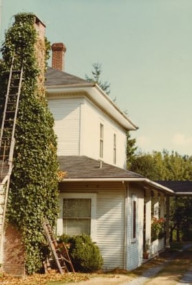
Detail of the Burnett home
https://search.heritageburnaby.ca/link/archivedescription37370
- Repository
- City of Burnaby Archives
- Date
- 1974
- Collection/Fonds
- Burnaby Historical Society fonds
- Description Level
- Item
- Physical Description
- 1 photograph : col. ; 9 x 12.8 cm
- Scope and Content
- Photograph of a house identified by a note on the back of the photograph as the home of Mr. Burnett (old street number 6561 Canada Way). Two ladders are visible resting against the ivy-covered chimney but only a partial view of the home is pictured.
- Repository
- City of Burnaby Archives
- Date
- 1974
- Collection/Fonds
- Burnaby Historical Society fonds
- Subseries
- Photographs subseries
- Physical Description
- 1 photograph : col. ; 9 x 12.8 cm
- Description Level
- Item
- Record No.
- 365-001
- Access Restriction
- No restrictions
- Reproduction Restriction
- Reproduce for fair dealing purposes only
- Accession Number
- BHS2007-04
- Scope and Content
- Photograph of a house identified by a note on the back of the photograph as the home of Mr. Burnett (old street number 6561 Canada Way). Two ladders are visible resting against the ivy-covered chimney but only a partial view of the home is pictured.
- Media Type
- Photograph
- Notes
- Title based on caption
- Geographic Access
- Canada Way
- Planning Study Area
- Lakeview-Mayfield Area
Images

Grazing cattle
https://search.heritageburnaby.ca/link/archivedescription36525
- Repository
- City of Burnaby Archives
- Date
- November 1978
- Collection/Fonds
- Burnaby Historical Society fonds
- Description Level
- Item
- Physical Description
- 1 photograph : col. ; 9 x 8.5 cm
- Scope and Content
- Photograph of cattle grazing on grass in a field between Canada Way and Burris Street.
- Repository
- City of Burnaby Archives
- Date
- November 1978
- Collection/Fonds
- Burnaby Historical Society fonds
- Subseries
- Lubbock family subseries
- Physical Description
- 1 photograph : col. ; 9 x 8.5 cm
- Description Level
- Item
- Record No.
- 289-014
- Access Restriction
- No restrictions
- Reproduction Restriction
- Reproduce for fair dealing purposes only
- Accession Number
- BHS1992-24
- Scope and Content
- Photograph of cattle grazing on grass in a field between Canada Way and Burris Street.
- Subjects
- Animals - Cows
- Media Type
- Photograph
- Notes
- Title based on contents of photograph
- Geographic Access
- Canada Way
- Grandview Highway
- Burris Street
- Historic Neighbourhood
- Burnaby Lake (Historic Neighbourhood)
- Planning Study Area
- Morley-Buckingham Area
Images


Interview with Minard Hill February 9, 1978 - Track 3
https://search.heritageburnaby.ca/link/oralhistory196
- Repository
- City of Burnaby Archives
- Date Range
- 1880-1914
- Length
- 0:10:09
- Summary
- This portion of the interview pertains to Minard Gerald "Gerry" Hill's relatives in England, his father's early life as well as life on the strawberry farm in Burnaby.
- Repository
- City of Burnaby Archives
- Summary
- This portion of the interview pertains to Minard Gerald "Gerry" Hill's relatives in England, his father's early life as well as life on the strawberry farm in Burnaby.
- Date Range
- 1880-1914
- Photo Info
- Minard Gerald Hill in uniform, 1914. Item no. 477-926
- Length
- 0:10:09
- Names
- Hill, Bernard R
- Geographic Access
- Douglas Road
- Canada Way
- Historic Neighbourhood
- Burnaby Lake (Historic Neighbourhood)
- Planning Study Area
- Douglas-Gilpin Area
- Interviewer
- Stevens, Colin
- Interview Date
- February 9, 1978
- Scope and Content
- Recording is of an interview with Minard Gerald "Gerry" Hill conducted by Colin Stevens, February 9, 1978. Major themes discussed are: the Burnaby Lake Neighbourhood, Gilley Brothers Logging Company and his father, Bernard Hill.
- Biographical Notes
- Minard Gerald “Gerry” Hill was born in Burnaby on July 31, 1893 to Marian (Berkeley) and Bernard Richard Hill. He was the youngest child in the family with older siblings Frank, Claude and Winnie. Bernard R. Hill was born in Bengal, India while his father worked for the East Indian Railway. He and his older brother Claude became strawberry farmers in Burnaby despite their years of training as engineers. Between them, the Hill brothers owned all the land between Burnaby Lake and Deer Lake where Deer Creek runs, and half way around Deer Lake. Bernard built his family home at Douglas Road near Deer Lake in 1892. After the decline in the strawberry industry, Bernard worked as a surveyor for the municipality. He also served as Burnaby Councillor and School Trustee. Gerry attended Miss Harriet Woodward’s kindergarten class, and went on to Edmonds School with Miss Ellen Lister as his teacher. He later went to Central high school in New Westminster, often on horseback. Gerry served in World War I, signing his recruitment papers November 9, 1914. When he returned home, he worked felling trees, then as an apprentice surveyor and finally as a carpenter. Minard Gerald “Gerry” Hill married Charlotte Elizabeth “Elizabeth” Vidal on September 28, 1920 and single-handedly built a house for him and his wife about a thousand feet from his parents’ home. He also bought property at Yellow Point, Vancouver Island around this time. By the early 1930s Gerry had moved to Yellow Point permanently and begun work building the lodge. Elizabeth and Gerry’s child, Richard Grant McEwan Hill was born at Ladysmith hospital. Charlotte Elizabeth “Elizabeth” (Vidal) Hill died February 11, 1984 at the age of eighty-seven. Minard Gerald “Gerry” Hill died January 30, 1988 at the age of ninety-three.
- Total Tracks
- 8
- Total Length
- 1:13:56
- Interviewee Name
- Hill, Minard Gerald "Gerry"
- Interview Location
- Yellow Point, Vancouver Island
- Collection/Fonds
- Burnaby Historical Society fonds
- Subseries
- Oral history subseries
- Media Type
- Sound Recording
- Web Notes
- Interview was digitized in 2010 allowing it to be accessible on Heritage Burnaby. The digitization project was initiated by the Community Heritage Commission with support from City of Burnaby Council and the BC History Digitization Program of the Irving K. Barber Learning Centre, University of British Columbia. It was recognized by the Heritage Society of BC with an award in 2012.
Images

Audio Tracks
Track three of interview with Minard Hill
Track three of interview with Minard Hill
https://search.heritageburnaby.ca/media/hpo/_Data/_Archives_Oral_Histories/_Unrestricted/MSS137-018-1/MSS137-018-1_Track_3.mp3![Lubbock family home and farm, [197-] (date of original), copied 1986 thumbnail](/media/hpo/_Data/_Archives_Images/_Unrestricted/204/204-720.jpg?width=280)
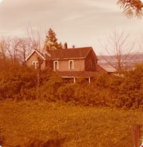
Lubbock family home and farm
https://search.heritageburnaby.ca/link/archivedescription35861
- Repository
- City of Burnaby Archives
- Date
- [197-] (date of original), copied 1986
- Collection/Fonds
- Burnaby Historical Society fonds
- Description Level
- Item
- Physical Description
- 1 photograph : b&w ; 12.7 x 17.8 cm print
- Scope and Content
- Photograph of the Lubbock family home and farm, built in 1898 by Edgar Sprott, brother of former Reeve, Charles F. Sprott. The Lubbock family moved into the house in 1915.
- Repository
- City of Burnaby Archives
- Date
- [197-] (date of original), copied 1986
- Collection/Fonds
- Burnaby Historical Society fonds
- Subseries
- Pioneer Tales subseries
- Physical Description
- 1 photograph : b&w ; 12.7 x 17.8 cm print
- Description Level
- Item
- Record No.
- 204-720
- Access Restriction
- No restrictions
- Reproduction Restriction
- Reproduce for fair dealing purposes only
- Accession Number
- BHS1988-03
- Scope and Content
- Photograph of the Lubbock family home and farm, built in 1898 by Edgar Sprott, brother of former Reeve, Charles F. Sprott. The Lubbock family moved into the house in 1915.
- Media Type
- Photograph
- Notes
- Title based on contents of photograph.
- A note with the photograph indicated that the old street address of this farm was 1 Arbor Lane.
- Geographic Access
- Grandview Highway
- Canada Way
- Burris Street
- Street Address
- 7803 Burris Street
- Historic Neighbourhood
- Burnaby Lake (Historic Neighbourhood)
- Planning Study Area
- Morley-Buckingham Area
Images
![Lubbock family home and farm, [197-] (date of original), copied 1986 thumbnail](/media/hpo/_Data/_Archives_Images/_Unrestricted/204/204-720.jpg)
![Lubbock family home and farm, [197-] (date of original), copied 1986 thumbnail](/media/hpo/_Data/_Archives_Images/_Unrestricted/204/204-721.jpg?width=280)
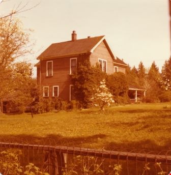
Lubbock family home and farm
https://search.heritageburnaby.ca/link/archivedescription35862
- Repository
- City of Burnaby Archives
- Date
- [197-] (date of original), copied 1986
- Collection/Fonds
- Burnaby Historical Society fonds
- Description Level
- Item
- Physical Description
- 1 photograph : b&w ; 12.7 x 17.8 cm print
- Scope and Content
- Photograph of cows grazing on the Lubbock farm with the family home seen in the background. The house was built in 1898 by Edgar Sprott, brother of former Reeve, Charles F. Sprott. The Lubbock family moved into the house in 1915.
- Repository
- City of Burnaby Archives
- Date
- [197-] (date of original), copied 1986
- Collection/Fonds
- Burnaby Historical Society fonds
- Subseries
- Pioneer Tales subseries
- Physical Description
- 1 photograph : b&w ; 12.7 x 17.8 cm print
- Description Level
- Item
- Record No.
- 204-721
- Access Restriction
- No restrictions
- Reproduction Restriction
- Reproduce for fair dealing purposes only
- Accession Number
- BHS1988-03
- Scope and Content
- Photograph of cows grazing on the Lubbock farm with the family home seen in the background. The house was built in 1898 by Edgar Sprott, brother of former Reeve, Charles F. Sprott. The Lubbock family moved into the house in 1915.
- Media Type
- Photograph
- Notes
- Title based on contents of photograph.
- A note with this photograph indicated that the old street address of this property was 1 Arbor Lane.
- Geographic Access
- Grandview Highway
- Canada Way
- Burris Street
- Street Address
- 7803 Burris Street
- Historic Neighbourhood
- Burnaby Lake (Historic Neighbourhood)
- Planning Study Area
- Morley-Buckingham Area
Images
![Lubbock family home and farm, [197-] (date of original), copied 1986 thumbnail](/media/hpo/_Data/_Archives_Images/_Unrestricted/204/204-721.jpg)

Lubbock farm
https://search.heritageburnaby.ca/link/archivedescription37248
- Repository
- City of Burnaby Archives
- Date
- April 1976
- Collection/Fonds
- Burnaby Historical Society fonds
- Description Level
- Item
- Physical Description
- 1 photograph : b&w ; 11.5 x 16.5 cm
- Scope and Content
- Photograph of the Lubbock farm and riding stable.
- Repository
- City of Burnaby Archives
- Date
- April 1976
- Collection/Fonds
- Burnaby Historical Society fonds
- Subseries
- Lubbock family subseries
- Physical Description
- 1 photograph : b&w ; 11.5 x 16.5 cm
- Description Level
- Item
- Record No.
- 342-022
- Access Restriction
- No restrictions
- Reproduction Restriction
- Reproduce for fair dealing purposes only
- Accession Number
- BHS1994-02
- Scope and Content
- Photograph of the Lubbock farm and riding stable.
- Subjects
- Agriculture - Farms
- Media Type
- Photograph
- Notes
- Title based on contents of photograph
- Note on verso of photograph reads: "COLUMBIAN 1976 APRIL"
- Geographic Access
- Grandview Highway
- Canada Way
- Burris Street
- Street Address
- 7803 Burris Street
- Historic Neighbourhood
- Burnaby Lake (Historic Neighbourhood)
- Planning Study Area
- Morley-Buckingham Area
Images

Lubbock photographs from album
https://search.heritageburnaby.ca/link/archivedescription64493
- Repository
- City of Burnaby Archives
- Date
- 1945-1988
- Collection/Fonds
- Burnaby Historical Society fonds
- Description Level
- File
- Physical Description
- 130 photographs : b&w and col. ; 20.5 x 25.5 cm or smaller
- Scope and Content
- Photographs of the Lubbock family, including their riding stables and horses, family events, their pets, and landscape and travel photographs. These photographs were originally housed in a photographic album.
- Repository
- City of Burnaby Archives
- Date
- 1945-1988
- Collection/Fonds
- Burnaby Historical Society fonds
- Subseries
- Lubbock family subseries
- Physical Description
- 130 photographs : b&w and col. ; 20.5 x 25.5 cm or smaller
- Description Level
- File
- Record No.
- 342-046
- Access Restriction
- In Archives only
- Reproduction Restriction
- May be restricted by third party rights
- Accession Number
- BHS1994-02
- Scope and Content
- Photographs of the Lubbock family, including their riding stables and horses, family events, their pets, and landscape and travel photographs. These photographs were originally housed in a photographic album.
- Names
- Lubbock, Ainsly
- Lubbock, Beatrice "Bea"
- Lubbock, Elizabeth
- Lubbock, Gordon
- Lubbock, John
- Lubbock, John Barker
- Lubbock, Mina
- Media Type
- Photograph
- Notes
- Title based on contents of photograph
- Geographic Access
- Grandview Highway
- Canada Way
- Burris Street
- Street Address
- 7803 Burris Street
- Historic Neighbourhood
- Burnaby Lake (Historic Neighbourhood)
- Planning Study Area
- Morley-Buckingham Area

Lubbock's farm
https://search.heritageburnaby.ca/link/archivedescription36517
- Repository
- City of Burnaby Archives
- Date
- 1977
- Collection/Fonds
- Burnaby Historical Society fonds
- Description Level
- Item
- Physical Description
- 1 photograph : col. ; 9 x 8.5 cm
- Scope and Content
- Copyright holder and creator are unknown. Copyright expires in 2053.
- Repository
- City of Burnaby Archives
- Date
- 1977
- Collection/Fonds
- Burnaby Historical Society fonds
- Subseries
- Lubbock family subseries
- Physical Description
- 1 photograph : col. ; 9 x 8.5 cm
- Description Level
- Item
- Record No.
- 289-006
- Access Restriction
- No restrictions
- Reproduction Restriction
- Reproduce for fair dealing purposes only
- Accession Number
- BHS1992-24
- Scope and Content
- Copyright holder and creator are unknown. Copyright expires in 2053.
- Media Type
- Photograph
- Notes
- Title based on contents of photograph
- Geographic Access
- Grandview Highway
- Canada Way
- Burris Street
- Street Address
- 7803 Burris Street
- Historic Neighbourhood
- Burnaby Lake (Historic Neighbourhood)
- Planning Study Area
- Morley-Buckingham Area
Images

Lubbock's farm house
https://search.heritageburnaby.ca/link/archivedescription36513
- Repository
- City of Burnaby Archives
- Date
- 1977
- Collection/Fonds
- Burnaby Historical Society fonds
- Description Level
- Item
- Physical Description
- 1 photograph : col. ; 9 x 8.5 cm
- Scope and Content
- Photograph of Lubbock's farm house and surrounding trees.
- Repository
- City of Burnaby Archives
- Date
- 1977
- Collection/Fonds
- Burnaby Historical Society fonds
- Subseries
- Lubbock family subseries
- Physical Description
- 1 photograph : col. ; 9 x 8.5 cm
- Description Level
- Item
- Record No.
- 289-002
- Access Restriction
- No restrictions
- Reproduction Restriction
- Reproduce for fair dealing purposes only
- Accession Number
- BHS1992-24
- Scope and Content
- Photograph of Lubbock's farm house and surrounding trees.
- Subjects
- Buildings - Residential - Houses
- Media Type
- Photograph
- Notes
- Title based on contents of photograph
- Geographic Access
- Grandview Highway
- Canada Way
- Burris Street
- Street Address
- 7803 Burris Street
- Historic Neighbourhood
- Burnaby Lake (Historic Neighbourhood)
- Planning Study Area
- Morley-Buckingham Area
Images


Lubbock's farm house
https://search.heritageburnaby.ca/link/archivedescription36514
- Repository
- City of Burnaby Archives
- Date
- 1977
- Collection/Fonds
- Burnaby Historical Society fonds
- Description Level
- Item
- Physical Description
- 1 photograph : col. ; 9 x 8.5 cm
- Scope and Content
- Photograph of Lubbock's farm house and surrounding yard.
- Repository
- City of Burnaby Archives
- Date
- 1977
- Collection/Fonds
- Burnaby Historical Society fonds
- Subseries
- Lubbock family subseries
- Physical Description
- 1 photograph : col. ; 9 x 8.5 cm
- Description Level
- Item
- Record No.
- 289-003
- Access Restriction
- No restrictions
- Reproduction Restriction
- Reproduce for fair dealing purposes only
- Accession Number
- BHS1992-24
- Scope and Content
- Photograph of Lubbock's farm house and surrounding yard.
- Subjects
- Buildings - Residential - Houses
- Media Type
- Photograph
- Notes
- Title based on contents of photograph
- Geographic Access
- Grandview Highway
- Canada Way
- Burris Street
- Street Address
- 7803 Burris Street
- Historic Neighbourhood
- Burnaby Lake (Historic Neighbourhood)
- Planning Study Area
- Morley-Buckingham Area
Images

Lubbock's farm house and parking lot
https://search.heritageburnaby.ca/link/archivedescription36515
- Repository
- City of Burnaby Archives
- Date
- 1977
- Collection/Fonds
- Burnaby Historical Society fonds
- Description Level
- Item
- Physical Description
- 1 photograph : col. ; 9 x 8.5 cm
- Scope and Content
- Photograph of the side of Lubbock's farm house. Horses are being lead across the parking lot, between the parked Datsun automobiles at the entrance to the farm off of Canada Way. Both the Burnaby Lake Riding Academy and the Burnaby Lake Riding Club operated out of the Lubbock farm.
- Repository
- City of Burnaby Archives
- Date
- 1977
- Collection/Fonds
- Burnaby Historical Society fonds
- Subseries
- Lubbock family subseries
- Physical Description
- 1 photograph : col. ; 9 x 8.5 cm
- Description Level
- Item
- Record No.
- 289-004
- Access Restriction
- No restrictions
- Reproduction Restriction
- Reproduce for fair dealing purposes only
- Accession Number
- BHS1992-24
- Scope and Content
- Photograph of the side of Lubbock's farm house. Horses are being lead across the parking lot, between the parked Datsun automobiles at the entrance to the farm off of Canada Way. Both the Burnaby Lake Riding Academy and the Burnaby Lake Riding Club operated out of the Lubbock farm.
- Media Type
- Photograph
- Notes
- Title based on contents of photograph
- Geographic Access
- Grandview Highway
- Canada Way
- Burris Street
- Street Address
- 7803 Burris Street
- Historic Neighbourhood
- Burnaby Lake (Historic Neighbourhood)
- Planning Study Area
- Morley-Buckingham Area
Images

Lubbock's farm yard
https://search.heritageburnaby.ca/link/archivedescription36518
- Repository
- City of Burnaby Archives
- Date
- 1977
- Collection/Fonds
- Burnaby Historical Society fonds
- Description Level
- Item
- Physical Description
- 1 photograph : col. ; 9 x 8.5 cm
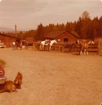
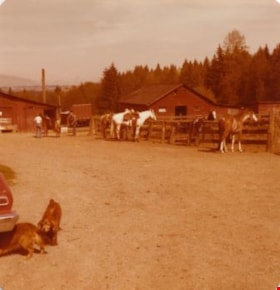
- Scope and Content
- Photograph of Lubbock's farm yard and riding stable. Three horses are tied to the paddock fence, partially tacked up. Another horse is still inside the paddock, and in the background three people are standing around a horse just outside one of the three barns visible on the property. In the foregou…
- Repository
- City of Burnaby Archives
- Date
- 1977
- Collection/Fonds
- Burnaby Historical Society fonds
- Subseries
- Lubbock family subseries
- Physical Description
- 1 photograph : col. ; 9 x 8.5 cm
- Description Level
- Item
- Record No.
- 289-007
- Access Restriction
- No restrictions
- Reproduction Restriction
- Reproduce for fair dealing purposes only
- Accession Number
- BHS1992-24
- Scope and Content
- Photograph of Lubbock's farm yard and riding stable. Three horses are tied to the paddock fence, partially tacked up. Another horse is still inside the paddock, and in the background three people are standing around a horse just outside one of the three barns visible on the property. In the foregound, one dog is following another as they crawl under a car. Both the Burnaby Lake Riding Academy and the Burnaby Lake Saddle Club operated out of the Lubbock farm.
- Media Type
- Photograph
- Notes
- Title based on contents of photograph
- Geographic Access
- Grandview Highway
- Canada Way
- Burris Street
- Street Address
- 7803 Burris Street
- Historic Neighbourhood
- Burnaby Lake (Historic Neighbourhood)
- Planning Study Area
- Morley-Buckingham Area
Images