Narrow Results By

Cariboo Road Overpass
https://search.heritageburnaby.ca/link/archivedescription45378
- Repository
- City of Burnaby Archives
- Date
- 1977
- Collection/Fonds
- Columbian Newspaper collection
- Description Level
- Item
- Physical Description
- 1 photograph : b&w ; 12.5 x 24 cm
- Scope and Content
- Photograph of the Cariboo Road Overpass at the begining stage of its construction.
- Repository
- City of Burnaby Archives
- Date
- 1977
- Collection/Fonds
- Columbian Newspaper collection
- Physical Description
- 1 photograph : b&w ; 12.5 x 24 cm
- Description Level
- Item
- Record No.
- 480-273
- Access Restriction
- No restrictions
- Reproduction Restriction
- No restrictions
- Accession Number
- 2003-02
- Scope and Content
- Photograph of the Cariboo Road Overpass at the begining stage of its construction.
- Subjects
- Construction - Road Construction
- Media Type
- Photograph
- Photographer
- Hodge, Craig
- Notes
- Title based on contents of photograph
- Newspaper clipping attached to verso of photograph reads: "Road builders created a sandpile for a giant with the first stage of the $917, 000 Cariboo Rd. overpass in Burnaby. Started several weeks ago the overpass actually consists of two bridges - one crossing railway tracks and Government St., the other spanning the Brunette River - and is expected to be complete early next year."
- Geographic Access
- Cariboo Road
- Trans Canada Highway
- Planning Study Area
- Burnaby Lake Area
Images


Construction of the Caribou Road to freeway link-up
https://search.heritageburnaby.ca/link/archivedescription45363
- Repository
- City of Burnaby Archives
- Date
- September 1977
- Collection/Fonds
- Columbian Newspaper collection
- Description Level
- Item
- Physical Description
- 1 photograph : b&w ; 10.5 x 18.5 cm
- Scope and Content
- Photograph of the construction of the Cariboo Road to 401 Freeway link-up. This was built in an effort to "ease [the] bottleneck of traffic at Stormount [sic] Interchange." The 401 Freeway is now known as the Trans Canada Highway.
- Repository
- City of Burnaby Archives
- Date
- September 1977
- Collection/Fonds
- Columbian Newspaper collection
- Physical Description
- 1 photograph : b&w ; 10.5 x 18.5 cm
- Description Level
- Item
- Record No.
- 480-258
- Access Restriction
- No restrictions
- Reproduction Restriction
- No restrictions
- Accession Number
- 2003-02
- Scope and Content
- Photograph of the construction of the Cariboo Road to 401 Freeway link-up. This was built in an effort to "ease [the] bottleneck of traffic at Stormount [sic] Interchange." The 401 Freeway is now known as the Trans Canada Highway.
- Subjects
- Construction - Road Construction
- Media Type
- Photograph
- Photographer
- Hodge, Craig
- Notes
- Title based on contents of photograph
- Newspaper clipping attached to verso of photograph reads: "Construction is now well underway on the new Caribou Road-freeway link-up which will ease bottleneck of traffic at Stormount [sic] Interchange."
- Geographic Access
- Trans Canada Highway
- Cariboo Road
- Planning Study Area
- Burnaby Lake Area
- Cariboo-Armstrong Area
Images


Stormont Overpass
https://search.heritageburnaby.ca/link/archivedescription45376
- Repository
- City of Burnaby Archives
- Date
- August 1978
- Collection/Fonds
- Columbian Newspaper collection
- Description Level
- Item
- Physical Description
- 1 photograph : b&w ; 12.5 x 24 cm
- Scope and Content
- Aerial photograph of Stormont Overpass which would provide a direct link from the Trans Canada Highway (previously named the 401 Freeway) to the Lougheed Highway and Simon Fraser University. This was taken when the excavation work was completed, and grading and paving still need to be done.
- Repository
- City of Burnaby Archives
- Date
- August 1978
- Collection/Fonds
- Columbian Newspaper collection
- Physical Description
- 1 photograph : b&w ; 12.5 x 24 cm
- Description Level
- Item
- Record No.
- 480-271
- Access Restriction
- No restrictions
- Reproduction Restriction
- No restrictions
- Accession Number
- 2003-02
- Scope and Content
- Aerial photograph of Stormont Overpass which would provide a direct link from the Trans Canada Highway (previously named the 401 Freeway) to the Lougheed Highway and Simon Fraser University. This was taken when the excavation work was completed, and grading and paving still need to be done.
- Media Type
- Photograph
- Photographer
- Hodge, Craig
- Notes
- Title based on contents of photograph
- Note in pencil on verso of photograph reads: "Altair Aviation / photo by / Craig Hodge"
- Geographic Access
- Cariboo Road
- Gaglardi Way
- Trans Canada Highway
- Historic Neighbourhood
- Burquitlam (Historic Neighbourhood)
- Planning Study Area
- Burnaby Lake Area
- Cameron Area
Images


Stormont Overpass
https://search.heritageburnaby.ca/link/archivedescription45377
- Repository
- City of Burnaby Archives
- Date
- August 1978
- Collection/Fonds
- Columbian Newspaper collection
- Description Level
- Item
- Physical Description
- 1 photograph : b&w ; 16.5 x 24 cm
- Scope and Content
- Aerial photograph of Stormont Overpass which would provide a direct link from the 401 Freeway to the Lougheed Highway and Simon Fraser University. This was taken when the excavation work was completed, and grading and paving still need to be done.
- Repository
- City of Burnaby Archives
- Date
- August 1978
- Collection/Fonds
- Columbian Newspaper collection
- Physical Description
- 1 photograph : b&w ; 16.5 x 24 cm
- Description Level
- Item
- Record No.
- 480-272
- Access Restriction
- No restrictions
- Reproduction Restriction
- No restrictions
- Accession Number
- 2003-02
- Scope and Content
- Aerial photograph of Stormont Overpass which would provide a direct link from the 401 Freeway to the Lougheed Highway and Simon Fraser University. This was taken when the excavation work was completed, and grading and paving still need to be done.
- Media Type
- Photograph
- Photographer
- Hodge, Craig
- Notes
- Title based on contents of photograph
- Newspaper clipping attached to verso of photograph reads: "After six years, work on the Stormont interchange in Burnaby is only a few weeks from completion. The huge clover-leaf junction of Gaglardi Way and the Freeway is on the top left-hand corner, with Gaglardi Way approaching from the bottom right where a bridge has been completed over the Burlington Northern tracks. An embankment linking that bridge with one over the Brunette River awaits only a layer of tarmac, and a path has been cleared through the woods to link up with the clover-leaf. The present access to the Freeway is along the road running from the left to right across the middle of the picture. The interchange will open next month."
- Note in pencil on verso of photograph reads: "Altair Aviation / photo by / Craig Hodge"
- Geographic Access
- Cariboo Road
- Gaglardi Way
- Trans Canada Highway
- Historic Neighbourhood
- Burquitlam (Historic Neighbourhood)
- Planning Study Area
- Burnaby Lake Area
- Cameron Area
Images

![Stormont Overpass, [1978] thumbnail](/media/hpo/_Data/_Archives_Images/_Unrestricted/480/480-275.jpg?width=280)
Stormont Overpass
https://search.heritageburnaby.ca/link/archivedescription45380
- Repository
- City of Burnaby Archives
- Date
- [1978]
- Collection/Fonds
- Columbian Newspaper collection
- Description Level
- Item
- Physical Description
- 1 photograph : b&w ; 16 x 24 cm
- Scope and Content
- Aerial photograph of Stormont Overpass which would provide a direct link from the Trans Canada Highway (previously named the 401 Freeway) to the Lougheed Highway and Simon Fraser University. This was taken when the excavation work was completed, and paving still need to be done.
- Repository
- City of Burnaby Archives
- Date
- [1978]
- Collection/Fonds
- Columbian Newspaper collection
- Physical Description
- 1 photograph : b&w ; 16 x 24 cm
- Description Level
- Item
- Record No.
- 480-275
- Access Restriction
- No restrictions
- Reproduction Restriction
- No restrictions
- Accession Number
- 2003-02
- Scope and Content
- Aerial photograph of Stormont Overpass which would provide a direct link from the Trans Canada Highway (previously named the 401 Freeway) to the Lougheed Highway and Simon Fraser University. This was taken when the excavation work was completed, and paving still need to be done.
- Media Type
- Photograph
- Photographer
- King, Basil
- Notes
- Title based on contents of photograph
- Note on verso of photograph reads: "One of the biggest Highways"
- Geographic Access
- Cariboo Road
- Gaglardi Way
- Trans Canada Highway
- Historic Neighbourhood
- Burquitlam (Historic Neighbourhood)
- Planning Study Area
- Burnaby Lake Area
- Cameron Area
Images
![Stormont Overpass, [1978] thumbnail](/media/hpo/_Data/_Archives_Images/_Unrestricted/480/480-275.jpg)
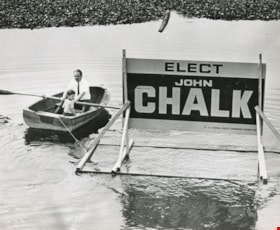
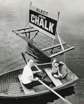
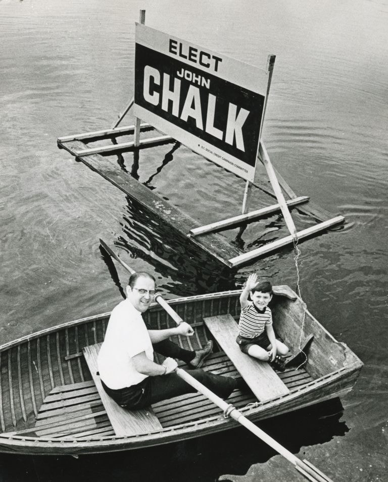
John and Timothy Chalk
https://search.heritageburnaby.ca/link/archivedescription46098
- Repository
- City of Burnaby Archives
- Date
- 1972
- Collection/Fonds
- Columbian Newspaper collection
- Description Level
- Item
- Physical Description
- 1 photograph : b&w ; 20 x 24.5 cm
- Scope and Content
- Photograph of John Chalk and his four year old son Timothy in a row boat, floating a large "Elect John Chalk" election sign out into the middle of Burnaby Lake. John Chalk was a teacher and was on the Burnaby school board from 1969 until 1972, when became the Social Credit candidate for Burnaby-Edm…
- Repository
- City of Burnaby Archives
- Date
- 1972
- Collection/Fonds
- Columbian Newspaper collection
- Physical Description
- 1 photograph : b&w ; 20 x 24.5 cm
- Description Level
- Item
- Record No.
- 480-986
- Access Restriction
- No restrictions
- Reproduction Restriction
- Reproduce for fair dealing purposes only
- Accession Number
- 2003-02
- Scope and Content
- Photograph of John Chalk and his four year old son Timothy in a row boat, floating a large "Elect John Chalk" election sign out into the middle of Burnaby Lake. John Chalk was a teacher and was on the Burnaby school board from 1969 until 1972, when became the Social Credit candidate for Burnaby-Edmonds.
- Media Type
- Photograph
- Notes
- Title based on contents of photograph
- Geographic Access
- Burnaby Lake
- Historic Neighbourhood
- Burnaby Lake (Historic Neighbourhood)
- Planning Study Area
- Burnaby Lake Area
Images

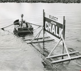
John and Timothy Chalk
https://search.heritageburnaby.ca/link/archivedescription46099
- Repository
- City of Burnaby Archives
- Date
- 1972
- Collection/Fonds
- Columbian Newspaper collection
- Description Level
- Item
- Physical Description
- 1 photograph : b&w ; 19.5 x 22.5 cm
- Scope and Content
- Photograph of John Chalk and his four year old son Timothy in a row boat, floating a large "Elect John Chalk" election sign out into the middle of Burnaby Lake. John Chalk was a teacher and was on the Burnaby school board from 1969 until 1972, when became the Social Credit candidate for Burnaby-Edm…
- Repository
- City of Burnaby Archives
- Date
- 1972
- Collection/Fonds
- Columbian Newspaper collection
- Physical Description
- 1 photograph : b&w ; 19.5 x 22.5 cm
- Description Level
- Item
- Record No.
- 480-987
- Access Restriction
- No restrictions
- Reproduction Restriction
- Reproduce for fair dealing purposes only
- Accession Number
- 2003-02
- Scope and Content
- Photograph of John Chalk and his four year old son Timothy in a row boat, floating a large "Elect John Chalk" election sign out into the middle of Burnaby Lake. John Chalk was a teacher and was on the Burnaby school board from 1969 until 1972, when became the Social Credit candidate for Burnaby-Edmonds.
- Media Type
- Photograph
- Notes
- Title based on contents of photograph
- Geographic Access
- Burnaby Lake
- Historic Neighbourhood
- Burnaby Lake (Historic Neighbourhood)
- Planning Study Area
- Burnaby Lake Area
Images

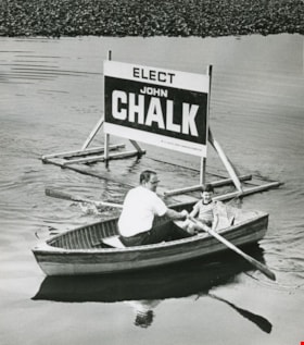
John and Timothy Chalk
https://search.heritageburnaby.ca/link/archivedescription46100
- Repository
- City of Burnaby Archives
- Date
- 1972
- Collection/Fonds
- Columbian Newspaper collection
- Description Level
- Item
- Physical Description
- 1 photograph : b&w ; 22.5 x 19.5 cm
- Scope and Content
- Photograph of John Chalk and his four year old son Timothy in a row boat, floating a large "Elect John Chalk" election sign out into the middle of Burnaby Lake. John Chalk was a teacher and was on the Burnaby school board from 1969 until 1972, when became the Social Credit candidate for Burnaby-Edm…
- Repository
- City of Burnaby Archives
- Date
- 1972
- Collection/Fonds
- Columbian Newspaper collection
- Physical Description
- 1 photograph : b&w ; 22.5 x 19.5 cm
- Description Level
- Item
- Record No.
- 480-988
- Access Restriction
- No restrictions
- Reproduction Restriction
- Reproduce for fair dealing purposes only
- Accession Number
- 2003-02
- Scope and Content
- Photograph of John Chalk and his four year old son Timothy in a row boat, floating a large "Elect John Chalk" election sign out into the middle of Burnaby Lake. John Chalk was a teacher and was on the Burnaby school board from 1969 until 1972, when became the Social Credit candidate for Burnaby-Edmonds.
- Media Type
- Photograph
- Notes
- Title based on contents of photograph
- Geographic Access
- Burnaby Lake
- Historic Neighbourhood
- Burnaby Lake (Historic Neighbourhood)
- Planning Study Area
- Burnaby Lake Area
Images
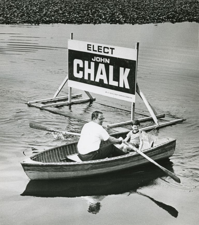
John and Timothy Chalk
https://search.heritageburnaby.ca/link/archivedescription46101
- Repository
- City of Burnaby Archives
- Date
- 1972
- Collection/Fonds
- Columbian Newspaper collection
- Description Level
- Item
- Physical Description
- 1 photograph : b&w ; 24.5 x 19.5 cm
- Scope and Content
- Photograph of John Chalk and his four year old son Timothy in a row boat, floating a large "Elect John Chalk" election sign out into the middle of Burnaby Lake. John Chalk was a teacher and was on the Burnaby school board from 1969 until 1972, when became the Social Credit candidate for Burnaby-Edm…
- Repository
- City of Burnaby Archives
- Date
- 1972
- Collection/Fonds
- Columbian Newspaper collection
- Physical Description
- 1 photograph : b&w ; 24.5 x 19.5 cm
- Description Level
- Item
- Record No.
- 480-989
- Access Restriction
- No restrictions
- Reproduction Restriction
- Reproduce for fair dealing purposes only
- Accession Number
- 2003-02
- Scope and Content
- Photograph of John Chalk and his four year old son Timothy in a row boat, floating a large "Elect John Chalk" election sign out into the middle of Burnaby Lake. John Chalk was a teacher and was on the Burnaby school board from 1969 until 1972, when became the Social Credit candidate for Burnaby-Edmonds.
- Media Type
- Photograph
- Notes
- Title based on contents of photograph
- Geographic Access
- Burnaby Lake
- Historic Neighbourhood
- Burnaby Lake (Historic Neighbourhood)
- Planning Study Area
- Burnaby Lake Area
Images
![Burnaby Lake, [1972] thumbnail](/media/hpo/_Data/_Archives_Images/_Unrestricted/371/389-006.jpg?width=280)
Burnaby Lake
https://search.heritageburnaby.ca/link/archivedescription39793
- Repository
- City of Burnaby Archives
- Date
- [1972]
- Collection/Fonds
- Burnaby Historical Society fonds
- Description Level
- Item
- Physical Description
- 1 photograph : b&w ; 8.7 x 13.3 cm
- Scope and Content
- Photograph taken looking across Burnaby Lake from the Burnaby Lake Rowing Pavilion. The pavilion and other facilities at Burnaby Lake were built in the early 1970s in preparation for the 1973 Canada Summer Games which were co-hosted in 1973 by Burnaby and New Westminster.
- Repository
- City of Burnaby Archives
- Date
- [1972]
- Collection/Fonds
- Burnaby Historical Society fonds
- Subseries
- Photographs subseries
- Physical Description
- 1 photograph : b&w ; 8.7 x 13.3 cm
- Description Level
- Item
- Record No.
- 389-006
- Access Restriction
- No restrictions
- Reproduction Restriction
- Reproduce for fair dealing purposes only
- Accession Number
- BHS2007-04
- Scope and Content
- Photograph taken looking across Burnaby Lake from the Burnaby Lake Rowing Pavilion. The pavilion and other facilities at Burnaby Lake were built in the early 1970s in preparation for the 1973 Canada Summer Games which were co-hosted in 1973 by Burnaby and New Westminster.
- Media Type
- Photograph
- Notes
- Title based on contents of photograph.
- Geographic Access
- Burnaby Lake
- Roberts Street
- Street Address
- 6871 Roberts Street
- Historic Neighbourhood
- Burnaby Lake (Historic Neighbourhood)
- Planning Study Area
- Burnaby Lake Area
Images
![Burnaby Lake, [1972] thumbnail](/media/hpo/_Data/_Archives_Images/_Unrestricted/371/389-006.jpg)
![Burnaby Lake Pavilion, [1972] thumbnail](/media/hpo/_Data/_Archives_Images/_Unrestricted/371/389-001.jpg?width=280)
Burnaby Lake Pavilion
https://search.heritageburnaby.ca/link/archivedescription38286
- Repository
- City of Burnaby Archives
- Date
- [1972]
- Collection/Fonds
- Burnaby Historical Society fonds
- Description Level
- Item
- Physical Description
- 1 photograph : sepia ; 8.7 x 13.3 cm
- Scope and Content
- Photograph of the Burnaby Lake Rowing Pavilion under construction. The pavilion and other facilities at Burnaby Lake were built in the early 1970s in preparation for the 1973 Canada Summer Games which were co-hosted in 1973 by Burnaby and New Westminster.
- Repository
- City of Burnaby Archives
- Date
- [1972]
- Collection/Fonds
- Burnaby Historical Society fonds
- Subseries
- Photographs subseries
- Physical Description
- 1 photograph : sepia ; 8.7 x 13.3 cm
- Description Level
- Item
- Record No.
- 389-001
- Access Restriction
- No restrictions
- Reproduction Restriction
- Reproduce for fair dealing purposes only
- Accession Number
- BHS2007-04
- Scope and Content
- Photograph of the Burnaby Lake Rowing Pavilion under construction. The pavilion and other facilities at Burnaby Lake were built in the early 1970s in preparation for the 1973 Canada Summer Games which were co-hosted in 1973 by Burnaby and New Westminster.
- Subjects
- Buildings - Recreational
- Media Type
- Photograph
- Notes
- Title based on contents of photograph.
- Geographic Access
- Burnaby Lake
- Roberts Street
- Street Address
- 6871 Roberts Street
- Historic Neighbourhood
- Burnaby Lake (Historic Neighbourhood)
- Planning Study Area
- Burnaby Lake Area
Images
![Burnaby Lake Pavilion, [1972] thumbnail](/media/hpo/_Data/_Archives_Images/_Unrestricted/371/389-001.jpg)
![Burnaby Lake Pavilion, [1972] thumbnail](/media/hpo/_Data/_Archives_Images/_Unrestricted/371/389-002.jpg?width=280)
Burnaby Lake Pavilion
https://search.heritageburnaby.ca/link/archivedescription39789
- Repository
- City of Burnaby Archives
- Date
- [1972]
- Collection/Fonds
- Burnaby Historical Society fonds
- Description Level
- Item
- Physical Description
- 1 photograph : b&w ; 8.7 x 13.3 cm
- Scope and Content
- Photograph of the Burnaby Lake Rowing Pavilion. The pavilion and other facilities at Burnaby Lake were built in the early 1970s in preparation for the 1973 Canada Summer Games which were co-hosted in 1973 by Burnaby and New Westminster.
- Repository
- City of Burnaby Archives
- Date
- [1972]
- Collection/Fonds
- Burnaby Historical Society fonds
- Subseries
- Photographs subseries
- Physical Description
- 1 photograph : b&w ; 8.7 x 13.3 cm
- Description Level
- Item
- Record No.
- 389-002
- Access Restriction
- No restrictions
- Reproduction Restriction
- Reproduce for fair dealing purposes only
- Accession Number
- BHS2007-04
- Scope and Content
- Photograph of the Burnaby Lake Rowing Pavilion. The pavilion and other facilities at Burnaby Lake were built in the early 1970s in preparation for the 1973 Canada Summer Games which were co-hosted in 1973 by Burnaby and New Westminster.
- Media Type
- Photograph
- Notes
- Title based on contents of photograph.
- Geographic Access
- Burnaby Lake
- Roberts Street
- Street Address
- 6871 Roberts Street
- Historic Neighbourhood
- Burnaby Lake (Historic Neighbourhood)
- Planning Study Area
- Burnaby Lake Area
Images
![Burnaby Lake Pavilion, [1972] thumbnail](/media/hpo/_Data/_Archives_Images/_Unrestricted/371/389-002.jpg)
![Burnaby Lake Pavilion, [1972] thumbnail](/media/hpo/_Data/_Archives_Images/_Unrestricted/371/389-004.jpg?width=280)
Burnaby Lake Pavilion
https://search.heritageburnaby.ca/link/archivedescription39791
- Repository
- City of Burnaby Archives
- Date
- [1972]
- Collection/Fonds
- Burnaby Historical Society fonds
- Description Level
- Item
- Physical Description
- 1 photograph : b&w ; 8.7 x 13.3 cm
- Scope and Content
- Photograph of two people carrying oars up a ramp at the Burnaby Lake Rowing Pavilion. The pavilion and other facilities at Burnaby Lake were built in the early 1970s in preparation for the 1973 Canada Summer Games which were co-hosted in 1973 by Burnaby and New Westminster.
- Repository
- City of Burnaby Archives
- Date
- [1972]
- Collection/Fonds
- Burnaby Historical Society fonds
- Subseries
- Photographs subseries
- Physical Description
- 1 photograph : b&w ; 8.7 x 13.3 cm
- Description Level
- Item
- Record No.
- 389-004
- Access Restriction
- No restrictions
- Reproduction Restriction
- Reproduce for fair dealing purposes only
- Accession Number
- BHS2007-04
- Scope and Content
- Photograph of two people carrying oars up a ramp at the Burnaby Lake Rowing Pavilion. The pavilion and other facilities at Burnaby Lake were built in the early 1970s in preparation for the 1973 Canada Summer Games which were co-hosted in 1973 by Burnaby and New Westminster.
- Subjects
- Buildings - Recreational
- Media Type
- Photograph
- Notes
- Title based on contents of photograph.
- Geographic Access
- Burnaby Lake
- Roberts Street
- Street Address
- 6871 Roberts Street
- Historic Neighbourhood
- Burnaby Lake (Historic Neighbourhood)
- Planning Study Area
- Burnaby Lake Area
Images
![Burnaby Lake Pavilion, [1972] thumbnail](/media/hpo/_Data/_Archives_Images/_Unrestricted/371/389-004.jpg)
![Burnaby Lake Pavilion, [1972] thumbnail](/media/hpo/_Data/_Archives_Images/_Unrestricted/371/389-005.jpg?width=280)
Burnaby Lake Pavilion
https://search.heritageburnaby.ca/link/archivedescription39792
- Repository
- City of Burnaby Archives
- Date
- [1972]
- Collection/Fonds
- Burnaby Historical Society fonds
- Description Level
- Item
- Physical Description
- 1 photograph : b&w ; 8.7 x 13.3 cm
- Scope and Content
- Photograph of an unidentified woman carrying an oar up a ramp at the Burnaby Lake Rowing Pavilion. The pavilion and other facilities at Burnaby Lake were built in the early 1970s in preparation for the 1973 Canada Summer Games which were co-hosted in 1973 by Burnaby and New Westminster.
- Repository
- City of Burnaby Archives
- Date
- [1972]
- Collection/Fonds
- Burnaby Historical Society fonds
- Subseries
- Photographs subseries
- Physical Description
- 1 photograph : b&w ; 8.7 x 13.3 cm
- Description Level
- Item
- Record No.
- 389-005
- Access Restriction
- No restrictions
- Reproduction Restriction
- Reproduce for fair dealing purposes only
- Accession Number
- BHS2007-04
- Scope and Content
- Photograph of an unidentified woman carrying an oar up a ramp at the Burnaby Lake Rowing Pavilion. The pavilion and other facilities at Burnaby Lake were built in the early 1970s in preparation for the 1973 Canada Summer Games which were co-hosted in 1973 by Burnaby and New Westminster.
- Subjects
- Buildings - Recreational
- Media Type
- Photograph
- Notes
- Title based on contents of photograph.
- Geographic Access
- Burnaby Lake
- Roberts Street
- Street Address
- 6871 Roberts Street
- Historic Neighbourhood
- Burnaby Lake (Historic Neighbourhood)
- Planning Study Area
- Burnaby Lake Area
Images
![Burnaby Lake Pavilion, [1972] thumbnail](/media/hpo/_Data/_Archives_Images/_Unrestricted/371/389-005.jpg)
![Burnaby Lake Pavilion entrance, [1972] thumbnail](/media/hpo/_Data/_Archives_Images/_Unrestricted/371/389-003.jpg?width=280)
Burnaby Lake Pavilion entrance
https://search.heritageburnaby.ca/link/archivedescription39790
- Repository
- City of Burnaby Archives
- Date
- [1972]
- Collection/Fonds
- Burnaby Historical Society fonds
- Description Level
- Item
- Physical Description
- 1 photograph : b&w ; 8.7 x 13.3 cm
- Scope and Content
- Photograph of the entrance to the Burnaby Lake Rowing Pavilion. The pavilion and other facilities at Burnaby Lake were built in the early 1970s in preparation for the 1973 Canada Summer Games which were co-hosted in 1973 by Burnaby and New Westminster.
- Repository
- City of Burnaby Archives
- Date
- [1972]
- Collection/Fonds
- Burnaby Historical Society fonds
- Subseries
- Photographs subseries
- Physical Description
- 1 photograph : b&w ; 8.7 x 13.3 cm
- Description Level
- Item
- Record No.
- 389-003
- Access Restriction
- No restrictions
- Reproduction Restriction
- Reproduce for fair dealing purposes only
- Accession Number
- BHS2007-04
- Scope and Content
- Photograph of the entrance to the Burnaby Lake Rowing Pavilion. The pavilion and other facilities at Burnaby Lake were built in the early 1970s in preparation for the 1973 Canada Summer Games which were co-hosted in 1973 by Burnaby and New Westminster.
- Subjects
- Buildings - Recreational
- Media Type
- Photograph
- Notes
- Title based on contents of photograph.
- Geographic Access
- Burnaby Lake
- Roberts Street
- Street Address
- 6871 Roberts Street
- Historic Neighbourhood
- Burnaby Lake (Historic Neighbourhood)
- Planning Study Area
- Burnaby Lake Area
Images
![Burnaby Lake Pavilion entrance, [1972] thumbnail](/media/hpo/_Data/_Archives_Images/_Unrestricted/371/389-003.jpg)

Burnaby Lake rowing course dredging
https://search.heritageburnaby.ca/link/archivedescription38303
- Repository
- City of Burnaby Archives
- Date
- 1971
- Collection/Fonds
- Burnaby Historical Society fonds
- Description Level
- Item
- Physical Description
- 1 photograph : col. ; 12.5 x 18 cm
- Scope and Content
- Aerial photograph of the Burnaby Lake rowing course being dredged in 1971, in preparation for the 1973 Canada Summer Games.
- Repository
- City of Burnaby Archives
- Date
- 1971
- Collection/Fonds
- Burnaby Historical Society fonds
- Subseries
- Photographs subseries
- Physical Description
- 1 photograph : col. ; 12.5 x 18 cm
- Description Level
- Item
- Record No.
- 400-001
- Access Restriction
- No restrictions
- Reproduction Restriction
- Reproduce for fair dealing purposes only
- Accession Number
- BHS2007-04
- Scope and Content
- Aerial photograph of the Burnaby Lake rowing course being dredged in 1971, in preparation for the 1973 Canada Summer Games.
- Media Type
- Photograph
- Notes
- Title based on contents of photograph
- Geographic Access
- Roberts Street
- Burnaby Lake
- Street Address
- 6871 Roberts Street
- Historic Neighbourhood
- Burnaby Lake (Historic Neighbourhood)
- Planning Study Area
- Burnaby Lake Area
Images
