Narrow Results By
Subject
- Agriculture - Farms 3
- Agriculture - Fruit and Berries 2
- Agriculture - Orchards 1
- Buildings - Agricultural - Barns 1
- Buildings - Commercial 1
- Buildings - Industrial - Mills 3
- Buildings - Residential - Cabins 1
- Buildings - Residential - Houses 9
- Buildings - Residential - Seniors Housing 2
- Geographic Features - Roads 3
- Industries - Forestry 2
- Industries - Logging/lumber 2

Coburn House
https://search.heritageburnaby.ca/link/landmark510
- Repository
- Burnaby Heritage Planning
- Description
- The Coburn House is a two and one-half storey plus basement Foursquare farm house. Prominently situated on a rise of land along the east side of Boundary Road overlooking Kingsway, it stands among single-family houses later constructed on its subdivided farm land.
- Associated Dates
- 1910
- Formal Recognition
- Heritage Designation, Community Heritage Register
- Other Names
- Minerva Jane Coburn House
- Street View URL
- Google Maps Street View
- Repository
- Burnaby Heritage Planning
- Other Names
- Minerva Jane Coburn House
- Geographic Access
- Boundary Road
- Associated Dates
- 1910
- Formal Recognition
- Heritage Designation, Community Heritage Register
- Enactment Type
- Bylaw No. 9184
- Enactment Date
- 08/05/1989
- Description
- The Coburn House is a two and one-half storey plus basement Foursquare farm house. Prominently situated on a rise of land along the east side of Boundary Road overlooking Kingsway, it stands among single-family houses later constructed on its subdivided farm land.
- Heritage Value
- The Coburn House is important as a surviving representation of Burnaby’s early settlement period, when the municipality was largely an agricultural and residential suburb. It was built in 1910 by carpenter William Kirkham for Minerva Jane Coburn (1868-1940), and three years later the builder and client were married. Together, they operated the Surprise Poultry Farm, and were frequent participants at the local Central Park Farmers' Institute Exhibitions. This house is valued as an excellent and well-preserved example of a substantial Edwardian era Foursquare farm house. Significant due to its generous size, dominant symmetry, the prominent verandah that wraps around the front and both sides, and the three roof dormers, this house retains a high degree of original material and integrity. The elevated siting of the house, its tall proportions and symmetrical appearance combined with its fine condition make this an excellent example of its type.
- Defining Elements
- Key elements that define the heritage character of the Coburn House include its: - prominent location on Boundary Road, on an elevated site overlooking Vancouver - residential form, scale and massing as expressed by its cubic massing and tall, dominant roof form - Foursquare style as exemplified by its symmetry, square floor plan, pyramidal bellcast roof and three hipped dormers - Edwardian era construction details such as narrow bevelled wooden siding, broad horizontal eave band with scroll-cut eave brackets, and simple window surrounds - wraparound verandah encircling three main facades, with hipped roof, square columns and closed balustrades, connected to one storey extension at rear - projecting bay window on the main floor south facade - original double-hung 1-over-1 wooden-sash windows, some in double assembly on the ground floor - internal red brick chimney
- Historic Neighbourhood
- Central Park (Historic Neighbourhood)
- Planning Study Area
- Garden Village Area
- Function
- Primary Historic--Single Dwelling
- Primary Current--Single Dwelling
- Community
- Burnaby
- Cadastral Identifier
- 002-653-427
- Boundaries
- The Coburn House is comprised of a single residential lot located at 5170 Boundary Road, Burnaby
- Area
- 541.91
- Contributing Resource
- Building
- Ownership
- Private
- Street Address
- 5170 Boundary Road
- Street View URL
- Google Maps Street View
Images


Bob and Olive Urquhart beside Boundary Road
https://search.heritageburnaby.ca/link/archivedescription36759
- Repository
- City of Burnaby Archives
- Date
- March 19, 1913 (date of original), copied 1992
- Collection/Fonds
- Burnaby Historical Society fonds
- Description Level
- Item
- Physical Description
- 1 photograph : b&w ; 10 x 8 cm print
- Scope and Content
- Photograph of Bob and Olive Urquhart soon after their marriage, (they were married March 15). Note the new wood planking on Boundary Road and the train track crossing sign past the house in the distance for the Burnaby Lake Interurban tram line. This photograph was taken looking north on Boundary…
- Repository
- City of Burnaby Archives
- Date
- March 19, 1913 (date of original), copied 1992
- Collection/Fonds
- Burnaby Historical Society fonds
- Subseries
- Burnaby Centennial Anthology subseries
- Physical Description
- 1 photograph : b&w ; 10 x 8 cm print
- Description Level
- Item
- Record No.
- 315-114
- Access Restriction
- No restrictions
- Reproduction Restriction
- No known restrictions
- Accession Number
- BHS1994-04
- Scope and Content
- Photograph of Bob and Olive Urquhart soon after their marriage, (they were married March 15). Note the new wood planking on Boundary Road and the train track crossing sign past the house in the distance for the Burnaby Lake Interurban tram line. This photograph was taken looking north on Boundary Road just south of the railway tracks.
- Subjects
- Geographic Features - Roads
- Media Type
- Photograph
- Notes
- Title based on contents of photograph
- Geographic Access
- Boundary Road
- Myrtle Street
- Historic Neighbourhood
- Broadview (Historic Neighbourhood)
- Planning Study Area
- West Central Valley Area
Images


Boundary Road and Hastings Street vicinity
https://search.heritageburnaby.ca/link/archivedescription35447
- Repository
- City of Burnaby Archives
- Date
- 1915 (date of original), copied 1986
- Collection/Fonds
- Burnaby Historical Society fonds
- Description Level
- Item
- Physical Description
- 1 photograph : b&w ; 12.7 x 17.8 cm print
- Scope and Content
- Photograph taken in Vancouver on Hastings Street looking east toward Burnaby and Boundary Road. The Hastings Street British Columbia Electric Railway (BCER) cars can be seen labouring up the hill.
- Repository
- City of Burnaby Archives
- Date
- 1915 (date of original), copied 1986
- Collection/Fonds
- Burnaby Historical Society fonds
- Subseries
- Pioneer Tales subseries
- Physical Description
- 1 photograph : b&w ; 12.7 x 17.8 cm print
- Description Level
- Item
- Record No.
- 204-305
- Access Restriction
- No restrictions
- Reproduction Restriction
- No restrictions
- Accession Number
- BHS1988-03
- Scope and Content
- Photograph taken in Vancouver on Hastings Street looking east toward Burnaby and Boundary Road. The Hastings Street British Columbia Electric Railway (BCER) cars can be seen labouring up the hill.
- Media Type
- Photograph
- Photographer
- Eaton, Dr. Carl
- Notes
- Title based on contents of photograph
- Geographic Access
- Boundary Road
- Hastings Street
- Historic Neighbourhood
- Vancouver Heights (Historic Neighbourhood)
- Planning Study Area
- Willingdon Heights Area
Images


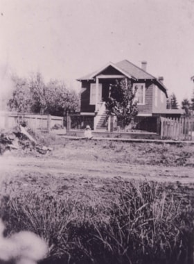
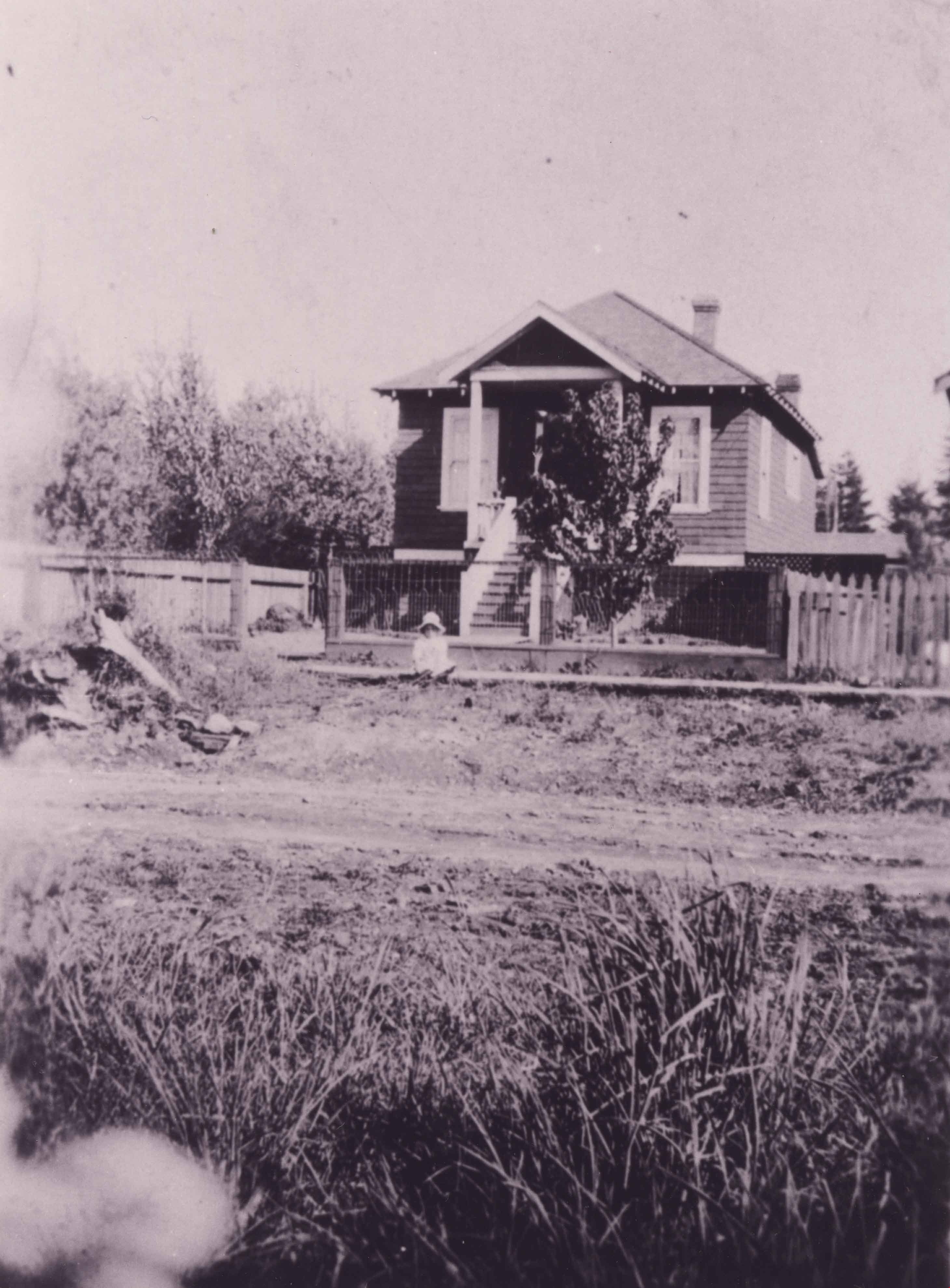
Boundary Road and Park Avenue station
https://search.heritageburnaby.ca/link/archivedescription36670
- Repository
- City of Burnaby Archives
- Date
- 1912 (date of original), copied 1992
- Collection/Fonds
- Burnaby Historical Society fonds
- Description Level
- Item
- Physical Description
- 1 photograph : b&w ; 10.1 x 14.9 cm print
- Scope and Content
- Photograph of Boundary Road, Park Avenue Interurban station, and the surrounding area, looking north from Kingsway. The Coburn house, built in 1906, is at the top of the hill on the right, current address 5170 Boundary Road.
- Repository
- City of Burnaby Archives
- Date
- 1912 (date of original), copied 1992
- Collection/Fonds
- Burnaby Historical Society fonds
- Subseries
- Burnaby Centennial Anthology subseries
- Physical Description
- 1 photograph : b&w ; 10.1 x 14.9 cm print
- Description Level
- Item
- Record No.
- 315-025
- Access Restriction
- No restrictions
- Reproduction Restriction
- No known restrictions
- Accession Number
- BHS1994-04
- Scope and Content
- Photograph of Boundary Road, Park Avenue Interurban station, and the surrounding area, looking north from Kingsway. The Coburn house, built in 1906, is at the top of the hill on the right, current address 5170 Boundary Road.
- Media Type
- Photograph
- Notes
- Title based on contents of photograph
- Annotation at bottom of photograph reads; "Boundary Rd and Park Ave Station"
- Geographic Access
- Boundary Road
- Kingsway
- Historic Neighbourhood
- Central Park (Historic Neighbourhood)
- Planning Study Area
- Garden Village Area
Images


Boundary Road Lumber Mill
https://search.heritageburnaby.ca/link/archivedescription38262
- Repository
- City of Burnaby Archives
- Date
- 1908
- Collection/Fonds
- Burnaby Historical Society fonds
- Description Level
- Item
- Physical Description
- 1 photograph : sepia ; 9 x 12 cm on 12.5 x 15 cm backing
- Scope and Content
- Photograph of an unidentified man standing in the forefront with a jersey cow to the right, while a row of cabins and cleared tress can be seen in the background. A caption written above the photograph reads: "Boundary Road Lumber Mill owned by E.W. Nicholson." Underneath the photograph is writte…
- Repository
- City of Burnaby Archives
- Date
- 1908
- Collection/Fonds
- Burnaby Historical Society fonds
- Subseries
- Margaret McCallum subseries
- Physical Description
- 1 photograph : sepia ; 9 x 12 cm on 12.5 x 15 cm backing
- Description Level
- Item
- Record No.
- 375-024
- Access Restriction
- No restrictions
- Reproduction Restriction
- No known restrictions
- Accession Number
- BHS1986-42
- Scope and Content
- Photograph of an unidentified man standing in the forefront with a jersey cow to the right, while a row of cabins and cleared tress can be seen in the background. A caption written above the photograph reads: "Boundary Road Lumber Mill owned by E.W. Nicholson." Underneath the photograph is written: "The first Jersey cow on the farm." On the back of the photograph it is noted that the buildings in the background were workmen's buildings.
- Media Type
- Photograph
- Notes
- Title based on caption
- Geographic Access
- Boundary Road
- Still Creek
- Street Address
- 2550 Boundary Road
- Historic Neighbourhood
- Broadview (Historic Neighbourhood)
- Planning Study Area
- West Central Valley Area
Images


Brook family home
https://search.heritageburnaby.ca/link/archivedescription34803
- Repository
- City of Burnaby Archives
- Date
- 1919
- Collection/Fonds
- Burnaby Historical Society fonds
- Description Level
- Item
- Physical Description
- 1 photograph : b&w ; 6.9 x 11.4 cm
- Scope and Content
- Photograph of the exterior of the Brook family home at 7979 12th Avenue, East Burnaby. This house later became the Normanna Rest Home, 7725 4th Street.
- Repository
- City of Burnaby Archives
- Date
- 1919
- Collection/Fonds
- Burnaby Historical Society fonds
- Subseries
- Kathleen Moore family subseries
- Physical Description
- 1 photograph : b&w ; 6.9 x 11.4 cm
- Description Level
- Item
- Record No.
- 135-001
- Access Restriction
- No restrictions
- Reproduction Restriction
- No known restrictions
- Accession Number
- BHS1985-03
- Scope and Content
- Photograph of the exterior of the Brook family home at 7979 12th Avenue, East Burnaby. This house later became the Normanna Rest Home, 7725 4th Street.
- Names
- Normanna Rest Home
- Media Type
- Photograph
- Photographer
- Moore, Godfrey
- Notes
- Title based on contents of photograph
- The accession register notes that the photos in the this collection were taken by Kathleen Moore's father
- Geographic Access
- 4th Street
- Street Address
- 7725 4th Street
- Historic Neighbourhood
- East Burnaby (Historic Neighbourhood)
- Planning Study Area
- Second Street Area
Images


Brook family house
https://search.heritageburnaby.ca/link/archivedescription34804
- Repository
- City of Burnaby Archives
- Date
- 1919
- Collection/Fonds
- Burnaby Historical Society fonds
- Description Level
- Item
- Physical Description
- 1 photograph : b&w ; 6.9 x 11.3 cm
- Scope and Content
- Photograph of the exterior of the Brook family home at 7979 12th Avenue, East Burnaby. This house later became the Normanna Rest Home, 7725 4th Street.
- Repository
- City of Burnaby Archives
- Date
- 1919
- Collection/Fonds
- Burnaby Historical Society fonds
- Subseries
- Kathleen Moore family subseries
- Physical Description
- 1 photograph : b&w ; 6.9 x 11.3 cm
- Description Level
- Item
- Record No.
- 135-002
- Access Restriction
- No restrictions
- Reproduction Restriction
- No known restrictions
- Accession Number
- BHS1985-03
- Scope and Content
- Photograph of the exterior of the Brook family home at 7979 12th Avenue, East Burnaby. This house later became the Normanna Rest Home, 7725 4th Street.
- Names
- Normanna Rest Home
- Media Type
- Photograph
- Photographer
- Moore, Godfrey
- Notes
- Title based on contents of photograph
- The accession register notes that the photos in the this collection were taken by Kathleen Moore's father
- Geographic Access
- 4th Street
- Street Address
- 7725 4th Street
- Historic Neighbourhood
- Edmonds (Historic Neighbourhood)
- Planning Study Area
- Second Street Area
Images


Edward W. Nicholson and Team of Horses Inside Tree Stump
https://search.heritageburnaby.ca/link/archivedescription38266
- Repository
- City of Burnaby Archives
- Date
- 1909
- Collection/Fonds
- Burnaby Historical Society fonds
- Description Level
- Item
- Physical Description
- 1 photograph : sepia ; 11 x 16.5 cm on 17.8 x 22.5 cm backing
- Scope and Content
- Photograph of Edward Nicholson standing with a team of horses inside the hollowed stump of a tree. Five other men and a dog are seated on planks on top of the stump and another man and two women are sitting to the left on the exposed roots of the tree. The man on seated to the right is identified …
- Repository
- City of Burnaby Archives
- Date
- 1909
- Collection/Fonds
- Burnaby Historical Society fonds
- Subseries
- Margaret McCallum subseries
- Physical Description
- 1 photograph : sepia ; 11 x 16.5 cm on 17.8 x 22.5 cm backing
- Description Level
- Item
- Record No.
- 375-028
- Access Restriction
- No restrictions
- Reproduction Restriction
- No known restrictions
- Accession Number
- BHS1986-42
- Scope and Content
- Photograph of Edward Nicholson standing with a team of horses inside the hollowed stump of a tree. Five other men and a dog are seated on planks on top of the stump and another man and two women are sitting to the left on the exposed roots of the tree. The man on seated to the right is identified as Duncan MacInnes.
- Subjects
- Transportation - Horses
- Plants - Trees
- Media Type
- Photograph
- Notes
- Title based on caption
- A note on the back of the photograph reads: "E.W. Nicholson first resident of Broadview District of Burnaby - 1900 May 23rd. Picture taken 1909. Edward W. Nicholson, with team of horses inside stump (Cedar). Stump 36 feet in diameter. Duncan MacInnes sitting extreme right. Horses were turned around inside stump."
- Geographic Access
- Boundary Road
- Street Address
- 2550 Boundary Road
- Historic Neighbourhood
- Broadview (Historic Neighbourhood)
- Planning Study Area
- West Central Valley Area
Images


E.W. Nicholson Home in Broadview District
https://search.heritageburnaby.ca/link/archivedescription38254
- Repository
- City of Burnaby Archives
- Date
- 1913
- Collection/Fonds
- Burnaby Historical Society fonds
- Description Level
- Item
- Physical Description
- 1 photograph : b&w ; 9 x 13 cm
- Scope and Content
- Photograph of a man identified as E.W. Nicholson standing in front of his home in the Broadview district.
- Repository
- City of Burnaby Archives
- Date
- 1913
- Collection/Fonds
- Burnaby Historical Society fonds
- Subseries
- Margaret McCallum subseries
- Physical Description
- 1 photograph : b&w ; 9 x 13 cm
- Description Level
- Item
- Record No.
- 375-016
- Access Restriction
- No restrictions
- Reproduction Restriction
- No known restrictions
- Accession Number
- BHS1986-42
- Scope and Content
- Photograph of a man identified as E.W. Nicholson standing in front of his home in the Broadview district.
- Subjects
- Buildings - Residential - Houses
- Names
- Nicholson, E.W.
- Media Type
- Photograph
- Notes
- Title based on caption
- A note on the back of the photograph reads: "First May Day in Broadview District of Burnaby. May 1913. E.W. Nicholson and home."
- Geographic Access
- Boundary Road
- Street Address
- 2550 Boundary Road
- Historic Neighbourhood
- Broadview (Historic Neighbourhood)
- Planning Study Area
- West Central Valley Area
Images

![Home of Richard and Clara Thorpe, [1911] thumbnail](/media/hpo/_Data/_BVM_Images/1990/199900610001.jpg?width=280)
Home of Richard and Clara Thorpe
https://search.heritageburnaby.ca/link/museumdescription1507
- Repository
- Burnaby Village Museum
- Date
- [1911]
- Collection/Fonds
- Burnaby Village Museum Photograph collection
- Description Level
- Item
- Physical Description
- 1 photograph : b&w ; 10x 14 cm, mounted on card 15 x 22.5 cm
- Scope and Content
- Photograph of the home of Richard and Clara Thorpe. Nancy Davis Allard is standing, holding baby Dorothy Thorp (later Spain) upright in a buggy at the foot of the stairs. Two unidentified woman are also visible sitting at the top of the stairs.
- Repository
- Burnaby Village Museum
- Collection/Fonds
- Burnaby Village Museum Photograph collection
- Description Level
- Item
- Physical Description
- 1 photograph : b&w ; 10x 14 cm, mounted on card 15 x 22.5 cm
- Scope and Content
- Photograph of the home of Richard and Clara Thorpe. Nancy Davis Allard is standing, holding baby Dorothy Thorp (later Spain) upright in a buggy at the foot of the stairs. Two unidentified woman are also visible sitting at the top of the stairs.
- Subjects
- Buildings - Residential - Houses
- Geographic Access
- Boundary Road
- Burke Street
- Accession Code
- BV999.61.1
- Access Restriction
- No restrictions
- Date
- [1911]
- Media Type
- Photograph
- Historic Neighbourhood
- Central Park (Historic Neighbourhood)
- Planning Study Area
- Garden Village Area
- Scan Resolution
- 600
- Scan Date
- 09-Jun-09
- Scale
- 100
- Notes
- Title based on contents of photograph
- Note in blue ink on verso of photograph reads: "Home of Richard and/ Clara Thorp - about 1911./ Built in 1907. Boundary/ & Burke St. - Burnaby/ I'm in the buggy, held upright by my/ dear friend Nance -"
Images
![Home of Richard and Clara Thorpe, [1911] thumbnail](/media/hpo/_Data/_BVM_Images/1990/199900610001.jpg)
![Lewis family, [1904] (date of original), copied 1985 thumbnail](/media/hpo/_Data/_Archives_Images/_Unrestricted/126/140-002.jpg?width=280)
Lewis family
https://search.heritageburnaby.ca/link/archivedescription34821
- Repository
- City of Burnaby Archives
- Date
- [1904] (date of original), copied 1985
- Collection/Fonds
- Burnaby Historical Society fonds
- Description Level
- Item
- Physical Description
- 1 photograph : b&w ; 8.8 x 12.5 cm print
- Scope and Content
- Photograph of Lewis family in front their house at 4th Street and 18th Avenue. "Pioneer Tales" identifies them as, left to right, Emma Lewis (mother) and children: Evelyn, Lizzie, Lillie (later, Lillie Porter), Albert, and Ernest. The description in the accession file reads "Greenhouse, root house…
- Repository
- City of Burnaby Archives
- Date
- [1904] (date of original), copied 1985
- Collection/Fonds
- Burnaby Historical Society fonds
- Subseries
- Lewis family subseries
- Physical Description
- 1 photograph : b&w ; 8.8 x 12.5 cm print
- Description Level
- Item
- Record No.
- 140-002
- Access Restriction
- No restrictions
- Reproduction Restriction
- No known restrictions
- Accession Number
- BHS1985-10
- Scope and Content
- Photograph of Lewis family in front their house at 4th Street and 18th Avenue. "Pioneer Tales" identifies them as, left to right, Emma Lewis (mother) and children: Evelyn, Lizzie, Lillie (later, Lillie Porter), Albert, and Ernest. The description in the accession file reads "Greenhouse, root house, cherry tree."
- Media Type
- Photograph
- Notes
- Title based on contents of photograph
- Geographic Access
- 4th Street
- 18th Avenue
- Historic Neighbourhood
- East Burnaby (Historic Neighbourhood)
- Planning Study Area
- Second Street Area
Images
![Lewis family, [1904] (date of original), copied 1985 thumbnail](/media/hpo/_Data/_Archives_Images/_Unrestricted/126/140-002.jpg)
![Lewis family, [1904] (date of original), copied 1985 thumbnail](/media/hpo/_Data/_Archives_Images/_Unrestricted/126/140-003.jpg?width=280)
Lewis family
https://search.heritageburnaby.ca/link/archivedescription34822
- Repository
- City of Burnaby Archives
- Date
- [1904] (date of original), copied 1985
- Collection/Fonds
- Burnaby Historical Society fonds
- Description Level
- Item
- Physical Description
- 1 photograph : b&w ; 8.8 x 12.5 cm print
- Scope and Content
- Photograph of the Lewis family in the orchard of their home at 4th Street and 18th Avenue. "Pioneer Tales" identifies them as, left to right, Emma Lewis (mother) and children: Lillie (later, Lillie Porter), Evelyn, Ernest, Lizzie, and Albert.
- Repository
- City of Burnaby Archives
- Date
- [1904] (date of original), copied 1985
- Collection/Fonds
- Burnaby Historical Society fonds
- Subseries
- Lewis family subseries
- Physical Description
- 1 photograph : b&w ; 8.8 x 12.5 cm print
- Description Level
- Item
- Record No.
- 140-003
- Access Restriction
- No restrictions
- Reproduction Restriction
- No known restrictions
- Accession Number
- BHS1985-10
- Scope and Content
- Photograph of the Lewis family in the orchard of their home at 4th Street and 18th Avenue. "Pioneer Tales" identifies them as, left to right, Emma Lewis (mother) and children: Lillie (later, Lillie Porter), Evelyn, Ernest, Lizzie, and Albert.
- Subjects
- Agriculture - Orchards
- Media Type
- Photograph
- Notes
- Title based on contents of photograph
- Geographic Access
- 4th Street
- 18th Avenue
- Historic Neighbourhood
- East Burnaby (Historic Neighbourhood)
- Planning Study Area
- Second Street Area
Images
![Lewis family, [1904] (date of original), copied 1985 thumbnail](/media/hpo/_Data/_Archives_Images/_Unrestricted/126/140-003.jpg)

Lewis family
https://search.heritageburnaby.ca/link/archivedescription35698
- Repository
- City of Burnaby Archives
- Date
- 1903 (date of original), copied 1986
- Collection/Fonds
- Burnaby Historical Society fonds
- Description Level
- Item
- Physical Description
- 1 photograph : b&w ; 12.7 x 17.8 cm print
- Scope and Content
- Photograph of (left to right) Lillie Lewis (sister - later Lillie Porter), William Lewis (father), Evelyn Lewis (sister), and Ernest Lewis (brother) picking strawberries at the side of their house. Note the apple trees all around. The other people in the picture are unidentified hired help.
- Repository
- City of Burnaby Archives
- Date
- 1903 (date of original), copied 1986
- Collection/Fonds
- Burnaby Historical Society fonds
- Subseries
- Pioneer Tales subseries
- Physical Description
- 1 photograph : b&w ; 12.7 x 17.8 cm print
- Description Level
- Item
- Record No.
- 204-556
- Access Restriction
- No restrictions
- Reproduction Restriction
- No known restrictions
- Accession Number
- BHS1988-03
- Scope and Content
- Photograph of (left to right) Lillie Lewis (sister - later Lillie Porter), William Lewis (father), Evelyn Lewis (sister), and Ernest Lewis (brother) picking strawberries at the side of their house. Note the apple trees all around. The other people in the picture are unidentified hired help.
- Subjects
- Occupations - Agricultural Labourers
- Agriculture - Fruit and Berries
- Occupations - Farmers
- Buildings - Residential - Houses
- Media Type
- Photograph
- Photographer
- Cooksley, William Thomas
- Notes
- Title based on contents of photograph
- Geographic Access
- 4th Street
- 18th Avenue
- Historic Neighbourhood
- East Burnaby (Historic Neighbourhood)
- Planning Study Area
- Second Street Area
Images


Lewis family
https://search.heritageburnaby.ca/link/archivedescription35699
- Repository
- City of Burnaby Archives
- Date
- 1904 (date of original), copied 1986
- Collection/Fonds
- Burnaby Historical Society fonds
- Description Level
- Item
- Physical Description
- 1 photograph : b&w ; 12.7 x 17.8 cm print
- Scope and Content
- Photograph of the Lewis family. Left to right: Mrs. Emma Lewis (mother) and children Evelyn, Lizzie, Lillie (later, Lillie Porter), Albert and Ernest in front of their home. Note the cherry trees, mostly Queen Anne reds.
- Repository
- City of Burnaby Archives
- Date
- 1904 (date of original), copied 1986
- Collection/Fonds
- Burnaby Historical Society fonds
- Subseries
- Pioneer Tales subseries
- Physical Description
- 1 photograph : b&w ; 12.7 x 17.8 cm print
- Description Level
- Item
- Record No.
- 204-557
- Access Restriction
- No restrictions
- Reproduction Restriction
- No known restrictions
- Accession Number
- BHS1988-03
- Scope and Content
- Photograph of the Lewis family. Left to right: Mrs. Emma Lewis (mother) and children Evelyn, Lizzie, Lillie (later, Lillie Porter), Albert and Ernest in front of their home. Note the cherry trees, mostly Queen Anne reds.
- Subjects
- Buildings - Residential - Houses
- Media Type
- Photograph
- Notes
- Title based on contents of photograph
- Geographic Access
- 4th Street
- 18th Avenue
- Historic Neighbourhood
- East Burnaby (Historic Neighbourhood)
- Planning Study Area
- Second Street Area
Images

![Lumber Camp and Mill, [between 1906 and 1908] thumbnail](/media/hpo/_Data/_Archives_Images/_Unrestricted/371/375-029.jpg?width=280)
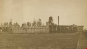
Lumber Camp and Mill
https://search.heritageburnaby.ca/link/archivedescription38267
- Repository
- City of Burnaby Archives
- Date
- [between 1906 and 1908]
- Collection/Fonds
- Burnaby Historical Society fonds
- Description Level
- Item
- Physical Description
- 1 photograph : sepia ; 11.8 x 17 cm on 17.7 x 22.7 cm backing
- Scope and Content
- Photograph of the Nicholson lumber camp and mill in the Broadview area of Burnaby. Approximately 12 men and women can be seen standing in front of the cabins and piles of planks (all are unidentified).
- Repository
- City of Burnaby Archives
- Date
- [between 1906 and 1908]
- Collection/Fonds
- Burnaby Historical Society fonds
- Subseries
- Margaret McCallum subseries
- Physical Description
- 1 photograph : sepia ; 11.8 x 17 cm on 17.7 x 22.7 cm backing
- Description Level
- Item
- Record No.
- 375-029
- Access Restriction
- No restrictions
- Reproduction Restriction
- No known restrictions
- Accession Number
- BHS1986-42
- Scope and Content
- Photograph of the Nicholson lumber camp and mill in the Broadview area of Burnaby. Approximately 12 men and women can be seen standing in front of the cabins and piles of planks (all are unidentified).
- Subjects
- Buildings - Residential - Cabins
- Industries - Forestry
- Occupations - Lumberjacks
- Industries - Logging/lumber
- Media Type
- Photograph
- Notes
- Title based on caption
- A note on the back of the photograph reads: "Lumber camp and mill at Boundary Road and Great Northern Railway 1906-1908 (before railway existed)."
- Geographic Access
- Boundary Road
- Street Address
- 2550 Boundary Road
- Historic Neighbourhood
- Broadview (Historic Neighbourhood)
- Planning Study Area
- West Central Valley Area
Images
![Lumber Camp and Mill, [between 1906 and 1908] thumbnail](/media/hpo/_Data/_Archives_Images/_Unrestricted/371/375-029.jpg)

Nicholson Farm
https://search.heritageburnaby.ca/link/archivedescription38255
- Repository
- City of Burnaby Archives
- Date
- 1910
- Collection/Fonds
- Burnaby Historical Society fonds
- Description Level
- Item
- Physical Description
- 1 photograph : b&w ; 10.2 x 15.2 cm
- Scope and Content
- Photograph of the home and barns at the farm of E.W. Nicholson and Elsie Nicholson.
- Repository
- City of Burnaby Archives
- Date
- 1910
- Collection/Fonds
- Burnaby Historical Society fonds
- Subseries
- Margaret McCallum subseries
- Physical Description
- 1 photograph : b&w ; 10.2 x 15.2 cm
- Description Level
- Item
- Record No.
- 375-017
- Access Restriction
- No restrictions
- Reproduction Restriction
- No known restrictions
- Accession Number
- BHS1986-42
- Scope and Content
- Photograph of the home and barns at the farm of E.W. Nicholson and Elsie Nicholson.
- Media Type
- Photograph
- Notes
- Title based on contents of photograph
- A note on the back of the photograph reads: "Home of E.W. Nicholson 1900-1951 and Elsie Nicholson 1934-1951. Boundary Road and Great Northern Railway. Property sold to Link-Belt Co. in 1951."
- Geographic Access
- Boundary Road
- Street Address
- 2550 Boundary Road
- Historic Neighbourhood
- Broadview (Historic Neighbourhood)
- Planning Study Area
- West Central Valley Area
Images

Pollard family house
https://search.heritageburnaby.ca/link/archivedescription37355
- Repository
- City of Burnaby Archives
- Date
- 1914 (date of original), copied 1998
- Collection/Fonds
- Burnaby Historical Society fonds
- Description Level
- Item
- Physical Description
- 1 photograph : b&w ; 12.5 x 17.5 cm print
- Scope and Content
- Photograph of the Pollard family house at 17th Avenue near 4th Street in East Burnaby. Eldest daughter May is seated on the sidewalk in front of the house.
- Repository
- City of Burnaby Archives
- Date
- 1914 (date of original), copied 1998
- Collection/Fonds
- Burnaby Historical Society fonds
- Subseries
- Pollard family subseries
- Physical Description
- 1 photograph : b&w ; 12.5 x 17.5 cm print
- Description Level
- Item
- Record No.
- 359-001
- Access Restriction
- No restrictions
- Reproduction Restriction
- No known restrictions
- Accession Number
- BHS1998-09
- Scope and Content
- Photograph of the Pollard family house at 17th Avenue near 4th Street in East Burnaby. Eldest daughter May is seated on the sidewalk in front of the house.
- Subjects
- Buildings - Residential - Houses
- Names
- Pollard, May
- Media Type
- Photograph
- Notes
- Title based on contents of photograph
- Geographic Access
- 17th Avenue
- 4th Street
- Historic Neighbourhood
- East Burnaby (Historic Neighbourhood)
- Planning Study Area
- Second Street Area
Images
![Ramsey family, [1916] (date of original), copied [1999] thumbnail](/media/hpo/_Data/_Archives_Images/_Unrestricted/371/399-001.jpg?width=280)
Ramsey family
https://search.heritageburnaby.ca/link/archivedescription38301
- Repository
- City of Burnaby Archives
- Date
- [1916] (date of original), copied [1999]
- Collection/Fonds
- Burnaby Historical Society fonds
- Description Level
- Item
- Physical Description
- 1 photograph : b&w ; 20.2 x 25.3 cm print
- Scope and Content
- Photograph of seven members of the Ramsey family in the backyard of home at 12th Avenue and 4th Street. Identified are: standing (l to r): Eva Lillian Ramsey, Annie Ramsey (mother), and Queenie Ramsey. Seated (l to r): Dorothy Ramsey, Ernest Ramsey (twin to Dorothy), Gordon Ramsey and Jessie Ramse…
- Repository
- City of Burnaby Archives
- Date
- [1916] (date of original), copied [1999]
- Collection/Fonds
- Burnaby Historical Society fonds
- Subseries
- Ramsey family subseries
- Physical Description
- 1 photograph : b&w ; 20.2 x 25.3 cm print
- Description Level
- Item
- Record No.
- 399-001
- Access Restriction
- No restrictions
- Reproduction Restriction
- No known restrictions
- Accession Number
- BHS1999-19
- Scope and Content
- Photograph of seven members of the Ramsey family in the backyard of home at 12th Avenue and 4th Street. Identified are: standing (l to r): Eva Lillian Ramsey, Annie Ramsey (mother), and Queenie Ramsey. Seated (l to r): Dorothy Ramsey, Ernest Ramsey (twin to Dorothy), Gordon Ramsey and Jessie Ramsey.
- Names
- Ramsey, Annie
- Ramsey, Dorothy
- Ramsey, Ernest
- Ramsey, Eva Lillian
- Ramsey, Gordon
- Ramsey, Jessie
- Ramsey, Queenie
- Media Type
- Photograph
- Notes
- Title based on contents of photograph
- Geographic Access
- 4th Street
- 12th Avenue
- Historic Neighbourhood
- East Burnaby (Historic Neighbourhood)
- Planning Study Area
- Second Street Area
Images
![Ramsey family, [1916] (date of original), copied [1999] thumbnail](/media/hpo/_Data/_Archives_Images/_Unrestricted/371/399-001.jpg)
Shull Lumber and Shingle Co.
https://search.heritageburnaby.ca/link/archivedescription34666
- Repository
- City of Burnaby Archives
- Date
- 1919
- Collection/Fonds
- Burnaby Historical Society fonds
- Description Level
- Item
- Physical Description
- 1 photograph : b&w ; 16.3 x 27.4 cm
- Scope and Content
- Photograph of the exterior of the dry kiln at Shull Lumber and Shingle Company at the foot of Boundary Road on the Fraser River.
- Repository
- City of Burnaby Archives
- Date
- 1919
- Collection/Fonds
- Burnaby Historical Society fonds
- Physical Description
- 1 photograph : b&w ; 16.3 x 27.4 cm
- Description Level
- Item
- Record No.
- 087-001
- Access Restriction
- No restrictions
- Reproduction Restriction
- No known restrictions
- Accession Number
- BHS2007-04
- Scope and Content
- Photograph of the exterior of the dry kiln at Shull Lumber and Shingle Company at the foot of Boundary Road on the Fraser River.
- Subjects
- Buildings - Industrial - Mills
- Media Type
- Photograph
- Notes
- Title based on contents of photograph
- Geographic Access
- Boundary Road
- Historic Neighbourhood
- Fraser Arm (Historic Neighbourhood)
- Planning Study Area
- Big Bend Area
Images

Shull Lumber and Shingle Co.
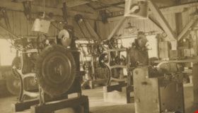
https://search.heritageburnaby.ca/link/archivedescription34667
- Repository
- City of Burnaby Archives
- Date
- 1919
- Collection/Fonds
- Burnaby Historical Society fonds
- Description Level
- Item
- Physical Description
- 1 photograph : b&w ; 16.7 x 27.5 cm
- Scope and Content
- Photograph of machinery in the interior of the filing room at the Shull Lumber and Shingle Company at the foot of Boundary Road on the Fraser River.
- Repository
- City of Burnaby Archives
- Date
- 1919
- Collection/Fonds
- Burnaby Historical Society fonds
- Physical Description
- 1 photograph : b&w ; 16.7 x 27.5 cm
- Description Level
- Item
- Record No.
- 087-002
- Access Restriction
- No restrictions
- Reproduction Restriction
- No known restrictions
- Accession Number
- BHS2007-04
- Scope and Content
- Photograph of machinery in the interior of the filing room at the Shull Lumber and Shingle Company at the foot of Boundary Road on the Fraser River.
- Media Type
- Photograph
- Notes
- Title based on contents of photograph
- Geographic Access
- Boundary Road
- Historic Neighbourhood
- Fraser Arm (Historic Neighbourhood)
- Planning Study Area
- Big Bend Area
Images
