Narrow Results By
Decade
- 2020s 41
- 2010s 26
- 2000s 146
- 1990s 158
- 1980s 146
- 1970s
- 1960s 252
- 1950s 255
- 1940s
- 1930s 167
- 1920s 319
- 1910s 143
- 1900s 64
- 1890s 28
- 1880s 10
- 1870s 5
- 1860s 6
- 1850s 3
- 1840s 1
- 1830s
- 1820s 1
- 1810s 2
- 1800s 2
- 1790s 2
- 1780s 2
- 1770s 2
- 1760s 2
- 1750s 2
- 1740s 2
- 1730s 2
- 1720s 2
- 1710s 2
- 1700s 2
- 1690s 2
- 1680s 2
- 1670s 1
- 1660s 1
- 1650s 1
- 1640s 1
- 1630s 1
- 1620s 1
- 1610s 1
- 1600s 1
- 1590s 1
- 1580s 1
- 1570s 1
- 1560s 1
- 1550s 1
- 1540s 1
- 1530s 1
- 1520s
- 1510s 1
- 1500s 1
- 1490s 1
- 1480s 1

Cascades Drive-In Theatre
https://search.heritageburnaby.ca/link/landmark689
- Repository
- Burnaby Heritage Planning
- Geographic Access
- Grandview Highway
- Associated Dates
- 1946
- Heritage Value
- The Cascades Drive-In Theatre was Canada's first drive-in and was started by George and William Steel and Joe and Art Johnson in 1946. Built along Grandview Highway (Canada Way) near Smith Street, the theatre opened on August 30, 1946. In 1977, the theatre was purchased by Don Soutar, Al Chappell and Norm Green and continued to operate until 1980. The property was then redeveloped as Cascades Village - a large condominium complex.
- Historic Neighbourhood
- Broadview (Historic Neighbourhood)
- Planning Study Area
- Cascade-Schou Area
- Street Address
- 4050 Grandview Highway
Images


Burnaby Village Museum
https://search.heritageburnaby.ca/link/landmark808
- Repository
- Burnaby Heritage Planning
- Geographic Access
- Deer Lake Avenue
- Associated Dates
- 1971
- Heritage Value
- The Burnaby Village Museum is a ten-acre heritage site located adjacent to Deer Lake. The site was originally created as a B.C. Centennial Project in 1971. The official sod turning for was April 11, 1971 by the then Governor General of Canada Roland Mitchener. The Village was initially managed by the Century Park Museum Association, a volunteer society of Burnaby citizens. Over the years many heritage building which could not be maintained in their original locations have been moved to the museum. Today half of the buildings in the village are heritage structures and the remainder are reproductions. In 1990 the City of Burnaby assumed direct management of the Village, and the museum became part of the Parks, Recreation and Culture Department. Visitors can enjoy the shops on Hill Street, ride the Parker 119 Carousel, and climb aboard the Interurban 1223 tram.
- Historic Neighbourhood
- Burnaby Lake (Historic Neighbourhood)
- Planning Study Area
- Douglas-Gilpin Area
- Morley-Buckingham Area
- Street Address
- 6501 Deer Lake Avenue
- Street View URL
- Google Maps Street View
Images


Douglas-Gilpin Neighbourhood
https://search.heritageburnaby.ca/link/landmark799
- Repository
- Burnaby Heritage Planning
- Associated Dates
- 1955-2008
- Heritage Value
- The Douglas-Gilpin Neighbourhood developed into a diverse area incorporating residential, business, educational and park districts in the period after 1955. The BCIT site was built in the early 1960s, shortly after the Burnaby Municipal Hall was located on Canada Way near Deer Lake in 1956. The construction of the Municipal Hall at this location fostered the creation of an administrative and business centre adjacent to the park, while the northern and central areas of the neighbourhood retained their primarily residential character.
- Historic Neighbourhood
- Burnaby Lake (Historic Neighbourhood)
- Planning Study Area
- Douglas-Gilpin Area
Images


Lake City Neighbourhood
https://search.heritageburnaby.ca/link/landmark793
- Repository
- Burnaby Heritage Planning
- Associated Dates
- 1955-2008
- Heritage Value
- When Simon Fraser University opened in 1965, approximately sixteen industrial properties had been developed in the Lake City Industrial Park. In addition, significant tracts of land in the western portion had been pre-cleared and graded in anticipation of additional development, while most of the eastern half remained forested. Some of the early companies to locate in the area were Nabob Foods, Volkswagen Canada, British Columbia Television Broadcasting, Simpson Sears, and H.Y. Louie Company Limited. Both Imperial Oil and Shell Oil established petroleum storage and distribution facilities in the area. Initially a heavy industrial area, by 1979, single family neighbourhoods south of Lougheed Highway and west of Eagle Creek had been largely developed. By the mid1980's, the Burnaby 200 multi-family development along Forest Grove Drive had also been completed.
- Planning Study Area
- Lake City Area
Images


Montague & Marcia Moore Residence
https://search.heritageburnaby.ca/link/landmark499
- Repository
- Burnaby Heritage Planning
- Description
- The Montague and Marcia Moore Residence, situated on Sperling Avenue, is a one and one-half storey wood-frame house with Tudor Revival elements such as half-timbering and diamond-leaded windows. The landscaping includes a large hedge at the front of the property. It is located on a lakefront site w…
- Associated Dates
- 1943
- Street View URL
- Google Maps Street View
- Repository
- Burnaby Heritage Planning
- Geographic Access
- Sperling Avenue
- Associated Dates
- 1943
- Description
- The Montague and Marcia Moore Residence, situated on Sperling Avenue, is a one and one-half storey wood-frame house with Tudor Revival elements such as half-timbering and diamond-leaded windows. The landscaping includes a large hedge at the front of the property. It is located on a lakefront site within the scenic Deer Lake Park Heritage Precinct.
- Heritage Value
- Located within the historic Deer Lake Park neighbourhood, the Montague and Marcia Moore Residence is valued as an example of the late persistence of the historicist influence on domestic architecture, at a time when it was still considered the height of good taste for a house to be designed in a recognizable period revival style. This is reflected in the rustic Tudor Revival elements such as half-timbering, waney-edged boards in the gables, brick nogging, diamond-leaded windows, and bird houses in the main gable. The cobblestone chimney, the major focal point of the house, was constructed from river stones that were transported from Lynn Canyon. Meticulously retained in its original condition, this was the last home to be constructed by the Moore family before the Second World War construction supply rationing took effect. It was built by Danish contractor, Hans Jorgensen Hau (1878-1944), who had a flair for the construction of homes with a rustic character, and shares a number of design features with Hau’s own house at 5070 Canada Way.
- Defining Elements
- Key elements that define the heritage character of the Montague and Marcia Moore Residence include its: - location on a lakefront site, within the Deer Lake Park Heritage Precinct - residential form, scale and massing as expressed by its one and one-half storey height, rectangular plan and front gabled roof - wood-frame construction - Tudor Revival elements such as stucco and wood half-timbering, diamond-leaded casement windows, scroll-cut brackets, brick nogging on the front façade, bird houses in the main front gable, waney-edged boards at gable peaks, plank front door with strap hinges and a prominent external cobblestone chimney - associated landscape features such as a granite wall, and mature coniferous and deciduous trees
- Historic Neighbourhood
- Burnaby Lake (Historic Neighbourhood)
- Planning Study Area
- Morley-Buckingham Area
- Organization
- Canadian Institute of Mining and Metallurgy
- Builder
- Hans Jorgensen Hau
- Function
- Primary Historic--Single Dwelling
- Primary Current--Single Dwelling
- Community
- Deer Lake
- Cadastral Identifier
- P.I.D.006-082-696
- Boundaries
- The Montague and Marcia Moore Residence is comprised of a single residential lot located at 5165 Sperling Avenue, Burnaby.
- Area
- 4104
- Contributing Resource
- Building
- Ownership
- Public (local)
- Documentation
- City of Burnaby Planning and Building Department, Heritage Site Files
- Street Address
- 5165 Sperling Avenue
- Street View URL
- Google Maps Street View
Images


Moore House
https://search.heritageburnaby.ca/link/landmark497
- Repository
- Burnaby Heritage Planning
- Description
- The Moore House is a one-storey, side-gabled house with stepped roof planes and a split-level attached garage. The house faces east, and features distinct river rock porch columns and a large central tapered chimney. It is located within the Deer Lake Park Heritage Precinct, and is adjacent to a re…
- Associated Dates
- 1941
- Formal Recognition
- Community Heritage Register
- Other Names
- Ethel Moore Residence
- Street View URL
- Google Maps Street View
- Repository
- Burnaby Heritage Planning
- Other Names
- Ethel Moore Residence
- Geographic Access
- Sperling Avenue
- Associated Dates
- 1941
- Formal Recognition
- Community Heritage Register
- Enactment Type
- Council Resolution
- Enactment Date
- 26/05/2003
- Description
- The Moore House is a one-storey, side-gabled house with stepped roof planes and a split-level attached garage. The house faces east, and features distinct river rock porch columns and a large central tapered chimney. It is located within the Deer Lake Park Heritage Precinct, and is adjacent to a related house, the Rosalie (Moore) Barrett Residence, built the following year.
- Heritage Value
- The Moore House is significant for its relationship to first owner, Ethel Hutchings Moore (1884-1948), who purchased the property from Maud and Harriet Woodward, two of Deer Lake's first residents. Moore purchased the property with the hopes of introducing her children into the house construction business. This house, built in 1941, borrows its design from a 'California Desert House' built in Carmel a few years earlier. Rendered in traditional materials, this modern style merges comfortably with the rustic British Arts and Crafts tradition of most Deer Lake houses. Unusual for being built during wartime date, it was built at a time when domestic construction was severely curtailed due to shortages of labour and material. It is now owned by the City of Burnaby and is part of the Deer Lake Park Heritage Precinct. The Moore House is significant as a testament to Deer Lake's continued popularity as a residential neighbourhood in the 1940s. Although Burnaby was serviced by a number of transportation links at the time, the increasing availability of automobiles provided improved access to outlying suburbs. Rising real estate prices in Vancouver and New Westminster attracted residents to this neighbourhood because of its relative affordability, central location and beautiful scenery.
- Defining Elements
- Key elements that define the heritage character of the Moore House include its: - location within the Deer Lake Park Heritage Precinct - residential form, scale and massing as expressed by its one-storey height, linear plan, side gabled roof with multiple roof planes and split-level attached garage - wood-frame construction with stucco cladding - river rock porch columns and external tapered chimney - decorative embellishments including scroll-cut stickwork on the rear elevation and waney-edged boards in the gable peaks - wooden-sash casement windows with three-part, horizontal leading - associated landscaping features, including stone wall at the front of the property and coniferous and deciduous trees surrounding the property
- Historic Neighbourhood
- Burnaby Lake (Historic Neighbourhood)
- Planning Study Area
- Morley-Buckingham Area
- Function
- Primary Historic--Single Dwelling
- Primary Current--Single Dwelling
- Community
- Deer Lake
- Cadastral Identifier
- P.I.D. 011-454-521
- Boundaries
- The Moore House is comprised of a single residential lot located at 5145 Sperling Avenue, Burnaby.
- Area
- 993.39
- Contributing Resource
- Building
- Ownership
- Public (local)
- Documentation
- City of Burnaby Planning and Building Department, Heritage Site Files
- Street Address
- 5145 Sperling Avenue
- Street View URL
- Google Maps Street View
Images


Morley-Buckingham Neighbourhood
https://search.heritageburnaby.ca/link/landmark829
- Repository
- Burnaby Heritage Planning
- Associated Dates
- 1955-2008
- Heritage Value
- In the 1980 "Residential Neighbourhood Environment Study," the Morley-Buckingham Neighbourhood is described as "perhaps Burnaby's most prestigious residential area. The lots are larger than most other areas of the Municipality and this, along with the new expensive housing developed over the past 10 years, has created a very desirable residential neighbourhood...The older area of Buckingham lies at the lower edge of the slope and here the homes and streets are more uniform and aged between 20 and 25 years old...to the east of Canada Way lies...a cluster townhouse development."
- Historic Neighbourhood
- Burnaby Lake (Historic Neighbourhood)
- Planning Study Area
- Morley-Buckingham Area
Images


Willingdon Heights Neighbourhood
https://search.heritageburnaby.ca/link/landmark670
- Repository
- Burnaby Heritage Planning
- Associated Dates
- 1925-1954
- Heritage Value
- Willingdon Heights was another new subdivision developed in Burnaby during the post-World War Two building boom. A brochure about the development published in 1948 proclaimed "the Willingdon Heights 500 home development project in Burnaby fulfills its promise to provide a self-contained community for former members of the armed services and their families...the largest single veteran housing project in Canada as far as homes for individual ownership is concerned, Willingdon Heights development was planned by the Central Mortgage and Housing Corporation...At this date the earlier built rows of homes have passable roads and the owners are improving lawns and gardens in spare time...eventually additional stores and professional services will be installed and recreational projects will add to the amenities of a community of congenial residents..."
- Planning Study Area
- Willingdon Heights Area
Images


Willingdon Heights Neighbourhood
https://search.heritageburnaby.ca/link/landmark777
- Repository
- Burnaby Heritage Planning
- Associated Dates
- 1955-2008
- Heritage Value
- The convenient location of Willingdon Heights to the Trans Canada Highway, Lougheed Highway and Hastings Street has fostered its development as a primarily residential commuter neighbourhood. Characterised in the post-World War Two period by predominantly single-family developments, the neighbourhood has retained this identity despite some higher density apartment buildings now found there.
- Planning Study Area
- Willingdon Heights Area
Images


Canada Games
https://search.heritageburnaby.ca/link/archivedescription98021
- Repository
- City of Burnaby Archives
- Date
- 1973
- Collection/Fonds
- Burnaby Historical Society fonds
- Description Level
- File
- Physical Description
- 10 photographs : col. slides ; 35 mm
- Scope and Content
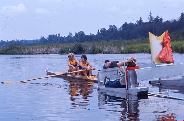
- Photographs of Burnaby Lake during the Canada Summer Games. Activities depicted include rowing and fishing.
- Repository
- City of Burnaby Archives
- Date
- 1973
- Collection/Fonds
- Burnaby Historical Society fonds
- Subseries
- Burnaby Scouts subseries
- Physical Description
- 10 photographs : col. slides ; 35 mm
- Description Level
- File
- Record No.
- 631-018
- Access Restriction
- No restrictions
- Reproduction Restriction
- Reproduce for fair dealing purposes only
- Accession Number
- BHS1994-05
- Scope and Content
- Photographs of Burnaby Lake during the Canada Summer Games. Activities depicted include rowing and fishing.
- Media Type
- Photograph
- Notes
- Transcribed title
- Title transcribed from envelope in which slides were originally held
Images
Canada Summer Games
https://search.heritageburnaby.ca/link/archivedescription97973
- Repository
- City of Burnaby Archives
- Date
- 1973
- Collection/Fonds
- Burnaby Historical Society fonds
- Description Level
- File
- Physical Description
- 32 photographs : col.
- Scope and Content
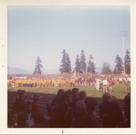
- Photographs of the Boy Scouts at the Canada Summer Games, held in Burnaby in 1973.
- Repository
- City of Burnaby Archives
- Date
- 1973
- Collection/Fonds
- Burnaby Historical Society fonds
- Subseries
- Burnaby Scouts subseries
- Physical Description
- 32 photographs : col.
- Description Level
- File
- Record No.
- 631-004
- Access Restriction
- No restrictions
- Reproduction Restriction
- Reproduce for fair dealing purposes only
- Accession Number
- BHS1994-05
- Scope and Content
- Photographs of the Boy Scouts at the Canada Summer Games, held in Burnaby in 1973.
- Media Type
- Photograph
- Notes
- Album note for 631-004-1 read: "Closing cermonies at Swanguard"
- Album note for 631-004-2 read: "Brand new bus
- Album note for 631-004-3 read: "Vincent Massey School"
- Album note for 631-004-4 read: "SFU observer deck". Note in blue ink on verso of photograph reads: "1973 Swim Meet"
- Album note for 631-004-8 read: "Closing cermonies Can Games Swanguard Stadium"
- Album note for 631-004-21 read: "Jerry White Jack Nichol"
- Album note for 631-004-23 read: "Betty Forbes"
- Album note for 631-004-24 read: "George C Betty Forbes"
- Album note for 631-004-25 read: "Betty Forbes". Caption adhered to recto reads: "Relaxation at Mather House"
- Album note for 631-004-27 read: "Doug Forbes Ted Hathaway standing". Caption adhered to recto reads: "Transportation at Yor [sic] Service"
- Album note for 631-004-28 read: "Betty Forbes Miguel Fernandes"
- Album note for 631-004-29 read: "Bob Dyer". Caption adhered to recto reads: "Your Instructions for Today"
- Caption adhered to recto of 631-004-30 reads: "Anyone for a lunch"
- Caption adhered to recto of 631-004-31 reads: "P.S.E. Loading for lunch"
- Album note for 631-004-32 read: "Barney Cavanaugh"
Images

Canada Summer Games
https://search.heritageburnaby.ca/link/archivedescription55147
- Repository
- City of Burnaby Archives
- Date
- 1973
- Collection/Fonds
- Burnaby Historical Society fonds
- Description Level
- File
- Physical Description
- 41 photographs: b&w and col.
- Scope and Content
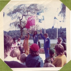
- Photographs of the Canada Summer Games, held in Burnaby in 1973. Photographs are adhered to poster paper decorated with black marker and captioned with typewritten labels.
- Repository
- City of Burnaby Archives
- Date
- 1973
- Collection/Fonds
- Burnaby Historical Society fonds
- Subseries
- Burnaby Scouts subseries
- Physical Description
- 41 photographs: b&w and col.
- Description Level
- File
- Record No.
- 631-003
- Access Restriction
- No restrictions
- Reproduction Restriction
- Reproduce for fair dealing purposes only
- Accession Number
- BHS1994-05
- Scope and Content
- Photographs of the Canada Summer Games, held in Burnaby in 1973. Photographs are adhered to poster paper decorated with black marker and captioned with typewritten labels.
- Media Type
- Photograph
- Notes
- Poster paper cut into smaller pieces prior to transfer to Archives.
Images

![Canada Summer Games uniforms, [1973] thumbnail](/media/hpo/_Data/_BVM_Images/2022/2022_0017_0021_001.jpg?width=280)
Canada Summer Games uniforms
https://search.heritageburnaby.ca/link/museumdescription18817
- Repository
- Burnaby Village Museum
- Date
- [1973]
- Collection/Fonds
- Denise Dullum fonds
- Description Level
- Item
- Physical Description
- 1 photograph : b&w ; 24.5 x 16 cm
- Scope and Content
- Photograph of three women standing together dressed in "Canda Summer Gamebirds" uniforms that were designed by Eaton's fashion department for the Canada Summer Games taking place in New Westminster and Burnaby in 1973. Woman standing in the centre is identified as Denise Dullum (nee Fouchard). Uni…
- Repository
- Burnaby Village Museum
- Collection/Fonds
- Denise Dullum fonds
- Description Level
- Item
- Physical Description
- 1 photograph : b&w ; 24.5 x 16 cm
- Scope and Content
- Photograph of three women standing together dressed in "Canda Summer Gamebirds" uniforms that were designed by Eaton's fashion department for the Canada Summer Games taking place in New Westminster and Burnaby in 1973. Woman standing in the centre is identified as Denise Dullum (nee Fouchard). Uniforms consist of a skirt, striped long sleeve blouse with tie and a short sleeved vest along with regalia buttons from the Summer Games adorning their vests and ties.
- Subjects
- Clothing - Uniforms
- Sports
- Names
- Dullum, Denise Fouchard
- Accession Code
- BV022.17.21
- Access Restriction
- No restrictions
- Reproduction Restriction
- May be restricted by third party rights
- Date
- [1973]
- Media Type
- Photograph
- Scan Resolution
- 600
- Scan Date
- 2022-07-04
- Notes
- Title based on contents of photograph
Images
![Canada Summer Games uniforms, [1973] thumbnail](/media/hpo/_Data/_BVM_Images/2022/2022_0017_0021_001.jpg)
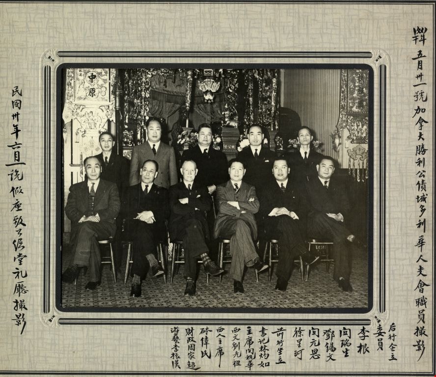
Canada Victory Bonds organization Chinese branch in Victoria, B.C
https://search.heritageburnaby.ca/link/museumdescription3376
- Repository
- Burnaby Village Museum
- Date
- 1 Jun. 1941
- Collection/Fonds
- Way Sang Yuen Wat Kee & Co. fonds
- Description Level
- Item
- Physical Description
- 1 photograph : b&w ; 18.5 x 23.5 cm (sight) in mat 30.5 x 35.5 cm
- Scope and Content
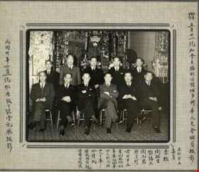
- Photograph of members of the Canada Victory Bonds organization Chinese branch in Victoria, B.C., seated and standing together in two rows. The photograph was taken on June 1, 1941 in the hall of the Chee Kung Tong Chinese Freemasons building. Lum Chuck Yue, a proprietor of the Way Sang Yuen Wat Kee…
- Repository
- Burnaby Village Museum
- Collection/Fonds
- Way Sang Yuen Wat Kee & Co. fonds
- Description Level
- Item
- Physical Description
- 1 photograph : b&w ; 18.5 x 23.5 cm (sight) in mat 30.5 x 35.5 cm
- Material Details
- Chinese characters have been added to recto of mat
- Scope and Content
- Photograph of members of the Canada Victory Bonds organization Chinese branch in Victoria, B.C., seated and standing together in two rows. The photograph was taken on June 1, 1941 in the hall of the Chee Kung Tong Chinese Freemasons building. Lum Chuck Yue, a proprietor of the Way Sang Yuen Wat Kee & Co. Chinese herbalist shop in Victoria, served as the committee secretary and is identified as sitting in the front row, first from the right.
- Subjects
- Organizations
- Persons - Chinese Canadians
- Accession Code
- BV985.5331.8
- Access Restriction
- No restrictions
- Reproduction Restriction
- May be restricted by third party rights
- Date
- 1 Jun. 1941
- Media Type
- Photograph
- Scan Resolution
- 600
- Scan Date
- 1/7/2010
- Scale
- 100
- Notes
- Title based on contents of photograph
- 1 b&w copy negative accompanying
Images

Canada Way
https://search.heritageburnaby.ca/link/archivedescription79957
- Repository
- City of Burnaby Archives
- Date
- September, 1976
- Collection/Fonds
- Burnaby Public Library Contemporary Visual Archive Project
- Description Level
- Item
- Physical Description
- 1 photograph : b&w ; 11 x 16 cm mounted on cardboard
- Scope and Content
- Photograph shows a view looking west along Canada Way, taken from Westminster Avenue.
- Repository
- City of Burnaby Archives
- Date
- September, 1976
- Collection/Fonds
- Burnaby Public Library Contemporary Visual Archive Project
- Physical Description
- 1 photograph : b&w ; 11 x 16 cm mounted on cardboard
- Description Level
- Item
- Record No.
- 556-522
- Access Restriction
- No restrictions
- Reproduction Restriction
- Reproduce for fair dealing purposes only
- Accession Number
- 2013-13
- Scope and Content
- Photograph shows a view looking west along Canada Way, taken from Westminster Avenue.
- Subjects
- Aerial Photographs
- Media Type
- Photograph
- Photographer
- Campbell, Peg
- Notes
- Scope note taken directly from BPL photograph description.
- 1 b&w copy negative : 10 x 12.5 cm accompanying
- Geographic Access
- Canada Way
- Westminster Avenue
- Planning Study Area
- Douglas-Gilpin Area
Images


Canada Way Food Market
https://search.heritageburnaby.ca/link/archivedescription79111
- Repository
- City of Burnaby Archives
- Date
- October, 1976
- Collection/Fonds
- Burnaby Public Library Contemporary Visual Archive Project
- Description Level
- Item
- Physical Description
- 1 photograph : b&w ; 11 x 16 cm mounted on cardboard
- Scope and Content
- Photograph shows the Canada Way Food Market at 4694 Canada Way and International Meats at 4692 Canada Way.
- Repository
- City of Burnaby Archives
- Date
- October, 1976
- Collection/Fonds
- Burnaby Public Library Contemporary Visual Archive Project
- Physical Description
- 1 photograph : b&w ; 11 x 16 cm mounted on cardboard
- Description Level
- Item
- Record No.
- 556-159
- Access Restriction
- No restrictions
- Reproduction Restriction
- Reproduce for fair dealing purposes only
- Accession Number
- 2013-13
- Scope and Content
- Photograph shows the Canada Way Food Market at 4694 Canada Way and International Meats at 4692 Canada Way.
- Media Type
- Photograph
- Photographer
- Salmon, Stu
- Notes
- Scope note taken directly from BPL photograph description.
- 1 b&w copy negative : 10 x 12.5 cm accompanying
- Geographic Access
- Canada Way
- Street Address
- 4692 Canada Way
- 4694 Canada Way
- Planning Study Area
- Douglas-Gilpin Area
Images


Cattle at Canada Way
https://search.heritageburnaby.ca/link/archivedescription36524
- Repository
- City of Burnaby Archives
- Date
- 1977
- Collection/Fonds
- Burnaby Historical Society fonds
- Description Level
- Item
- Physical Description
- 1 photograph : col. ; 9 x 8.5 cm
- Scope and Content
- Photograph of cattle grazing on the grass, taken from Burris Street, looking towards Canada Way.
- Repository
- City of Burnaby Archives
- Date
- 1977
- Collection/Fonds
- Burnaby Historical Society fonds
- Subseries
- Lubbock family subseries
- Physical Description
- 1 photograph : col. ; 9 x 8.5 cm
- Description Level
- Item
- Record No.
- 289-013
- Access Restriction
- No restrictions
- Reproduction Restriction
- Reproduce for fair dealing purposes only
- Accession Number
- BHS1992-24
- Scope and Content
- Photograph of cattle grazing on the grass, taken from Burris Street, looking towards Canada Way.
- Subjects
- Animals - Cows
- Media Type
- Photograph
- Notes
- Title based on contents of photograph
- Geographic Access
- Canada Way
- Burris Street
- Historic Neighbourhood
- Burnaby Lake (Historic Neighbourhood)
- Planning Study Area
- Morley-Buckingham Area
Images

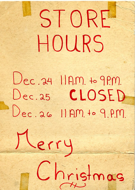
![Christmas hours sign for Canada Way Food Market, [197-] thumbnail](/media/hpo/_Data/_BVM_Textual_Records/2023/2023_0025_0004_001.jpg?width=280)
Christmas hours sign for Canada Way Food Market
https://search.heritageburnaby.ca/link/museumdescription20342
- Repository
- Burnaby Village Museum
- Date
- [197-]
- Collection/Fonds
- Harry Toy fonds
- Description Level
- Item
- Physical Description
- 1 sign : red ink on cardboard
- Scope and Content
- Item consists of a double sided handwritten sign in red ink listing Christmas store hours for the Canada Way Food Market. Sign reads: "STORE HOURS / Dec. 24 11 A.M. to 9 P.M. / Dec. 25 Closed / Dec. 26 11 A.M. to 9 P.M. / Merry / Christmas". The Canada Way Food Market was located at 4694 Canada Wa…
- Repository
- Burnaby Village Museum
- Collection/Fonds
- Harry Toy fonds
- Description Level
- Item
- Physical Description
- 1 sign : red ink on cardboard
- Scope and Content
- Item consists of a double sided handwritten sign in red ink listing Christmas store hours for the Canada Way Food Market. Sign reads: "STORE HOURS / Dec. 24 11 A.M. to 9 P.M. / Dec. 25 Closed / Dec. 26 11 A.M. to 9 P.M. / Merry / Christmas". The Canada Way Food Market was located at 4694 Canada Way, Burnaby.
- Subjects
- Holidays - Christmas
- Names
- Canada Way Food Market
- Accession Code
- BV023.25.4
- Access Restriction
- No restrictions
- Reproduction Restriction
- No known restrictions
- Date
- [197-]
- Media Type
- Textual Record
- Related Material
- See also BV023.16.19 - Interview with Harry Toy, Beverley Babey and Christina Toy
- For associated artifacts from Canada Way Food Market see Accession BV023.17
- Scan Resolution
- 600
- Scan Date
- 2023-11-30
- Notes
- Title based on contents of item
Images
![Christmas hours sign for Canada Way Food Market, [197-] thumbnail](/media/hpo/_Data/_BVM_Textual_Records/2023/2023_0025_0004_001.jpg)
![Harry's new prices sign for Canada Way Food Market, [197-] thumbnail](/media/hpo/_Data/_BVM_Textual_Records/2023/2023_0025_0008_001.jpg?width=280)
Harry's new prices sign for Canada Way Food Market
https://search.heritageburnaby.ca/link/museumdescription20344
- Repository
- Burnaby Village Museum
- Date
- [197-]
- Collection/Fonds
- Harry Toy fonds
- Description Level
- Item
- Physical Description
- 1 sign : plastic dry erase sheet
- Scope and Content
- Item consists of a handwritten sign in black marker on verso of a Dairyland Products list. The handwritten sign is titled "HARRY - NEW PRICES" listing prices for various food products sold at the Canada Way Food Market located at 4694 Canada Way, Burnaby. Other side of sign is titled "Dairyland SUP…
- Repository
- Burnaby Village Museum
- Collection/Fonds
- Harry Toy fonds
- Description Level
- Item
- Physical Description
- 1 sign : plastic dry erase sheet
- Material Details
- dry erase sheet; printed in col. one side; verso of sign with handwritten notes in black ink
- Scope and Content
- Item consists of a handwritten sign in black marker on verso of a Dairyland Products list. The handwritten sign is titled "HARRY - NEW PRICES" listing prices for various food products sold at the Canada Way Food Market located at 4694 Canada Way, Burnaby. Other side of sign is titled "Dairyland SUPER COOL TASTE" and includes various Dairyland products with refillable white oval shape next to name of each product.
- Names
- Canada Way Food Market
- Accession Code
- BV023.25.8
- Access Restriction
- No restrictions
- Reproduction Restriction
- No known restrictions
- Date
- [197-]
- Media Type
- Textual Record
- Related Material
- See also BV023.16.19 - Interview with Harry Toy, Beverley Babey and Christina Toy
- For associated artifacts from Canada Way Food Market see Accession BV023.17
- Scan Resolution
- 600
- Scan Date
- 2023-11-30
- Notes
- Title based on contents of item
Images
![Harry's new prices sign for Canada Way Food Market, [197-] thumbnail](/media/hpo/_Data/_BVM_Textual_Records/2023/2023_0025_0008_001.jpg)

![Harry Toy at cash register inside Canada Way Food Market, [May 1972] thumbnail](/media/hpo/_Data/_BVM_Images/2023/2023_0025_0014_001.jpg?width=280)
Harry Toy at cash register inside Canada Way Food Market
https://search.heritageburnaby.ca/link/museumdescription20353
- Repository
- Burnaby Village Museum
- Date
- [May 1972]
- Collection/Fonds
- Harry Toy fonds
- Description Level
- Item
- Physical Description
- 1 photograph : col. ; 10 x 15 cm
- Scope and Content
- Photograph of Harry Toy standing at cash register inside Canada Way Food Market located at 4694 Canada Way, Burnaby. Store products are visible behind him and hanging over his head.
- Repository
- Burnaby Village Museum
- Collection/Fonds
- Harry Toy fonds
- Series
- Harry Toy photographs series
- Description Level
- Item
- Physical Description
- 1 photograph : col. ; 10 x 15 cm
- Scope and Content
- Photograph of Harry Toy standing at cash register inside Canada Way Food Market located at 4694 Canada Way, Burnaby. Store products are visible behind him and hanging over his head.
- Geographic Access
- Canada Way
- Street Address
- 4694 Canada Way
- Accession Code
- BV023.25.14
- Access Restriction
- No restrictions
- Reproduction Restriction
- No known restrictions
- Date
- [May 1972]
- Media Type
- Photograph
- Related Material
- See also BV023.16.19 - Interview with Harry Toy, Beverley Babey and Christina Toy
- For associated artifacts from Canada Way Food Market see Accession BV023.17
- Scan Resolution
- 600
- Scan Date
- 2023-12-01
- Notes
- Title based on contents of photograph
Images
![Harry Toy at cash register inside Canada Way Food Market, [May 1972] thumbnail](/media/hpo/_Data/_BVM_Images/2023/2023_0025_0014_001.jpg)