Narrow Results By
Decade
- 2020s 14
- 2010s
- 2000s 116
- 1990s 140
- 1980s 98
- 1970s 150
- 1960s 125
- 1950s 177
- 1940s 144
- 1930s 193
- 1920s 392
- 1910s 305
- 1900s 173
- 1890s 98
- 1880s 18
- 1870s 11
- 1860s
- 1850s 6
- 1840s 1
- 1810s 1
- 1800s 1
- 1790s 1
- 1780s
- 1770s 1
- 1760s 1
- 1750s 1
- 1740s 1
- 1730s 1
- 1720s 1
- 1710s 1
- 1700s 1
- 1690s 1
- 1680s 1
- 1670s 1
- 1660s 1
- 1650s 1
- 1640s 1
- 1630s 1
- 1620s 1
- 1610s 1
- 1600s 1
- 1590s 1
- 1580s 1
- 1570s 1
- 1560s 1
- 1550s 1
- 1540s 1
- 1530s 1
- 1520s 1
- 1510s 1
- 1500s
- 1490s 1
- 1480s 1
Person / Organization
- Alpha Secondary School 1
- Aujla, Kehar Singh 1
- Babey, Beverley 1
- Brentwood Park School 1
- Brentwood Shopping Centre 1
- British Columbia Organization to Fight Racism 1
- Burnaby Multicultural Society 1
- Burnaby School Board 1
- Burnaby South High School 1
- Burnaby Symphony Orchestra 1
- Burnaby Village Museum 1
- Burquest 2
Heritage BC Annual Conference, New Westminster, BC - 2018 May 10-12
https://search.heritageburnaby.ca/link/councilreport81759
- Repository
- City of Burnaby Archives
- Report ID
- 92361
- Meeting Date
- 16-Apr-2018
- Format
- Council - Committee Report
- Collection/Fonds
- City Council and Office of the City Clerk fonds
- Repository
- City of Burnaby Archives
- Report ID
- 92361
- Meeting Date
- 16-Apr-2018
- Format
- Council - Committee Report
- Collection/Fonds
- City Council and Office of the City Clerk fonds
Documents
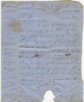
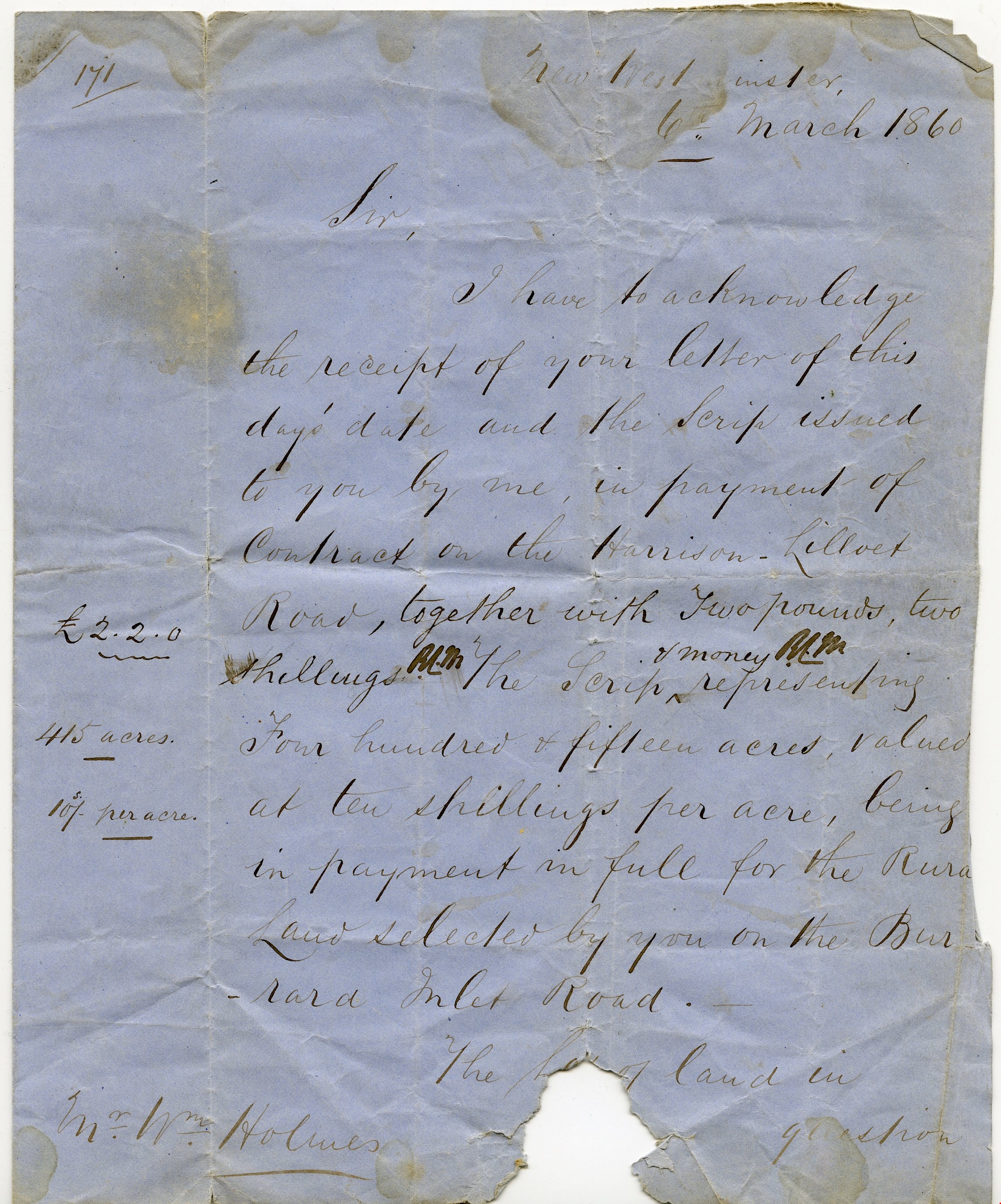
Letter re payment of Lot No. 1, Group 1, New Westminster District
https://search.heritageburnaby.ca/link/museumdescription10404
- Repository
- Burnaby Village Museum
- Date
- 6 Mar. 1860
- Collection/Fonds
- William Holmes fonds
- Description Level
- Item
- Physical Description
- 1 p. textual record ; folded
- Scope and Content
- Item consists of a handwritten letter on blue paper dated "6th March 1860". The letter is addressed to Mr. Wm. Holmes from Colonel Moody regarding payment of a contract on Harrison Lilloet Road and two pounds two shillings scrip payment for land on Burrard Inlet Road..."Lot No. 1, Group 1, Rural La…
- Repository
- Burnaby Village Museum
- Collection/Fonds
- William Holmes fonds
- Description Level
- Item
- Physical Description
- 1 p. textual record ; folded
- Scope and Content
- Item consists of a handwritten letter on blue paper dated "6th March 1860". The letter is addressed to Mr. Wm. Holmes from Colonel Moody regarding payment of a contract on Harrison Lilloet Road and two pounds two shillings scrip payment for land on Burrard Inlet Road..."Lot No. 1, Group 1, Rural Land, New Westminster District..."
- Accession Code
- BV997.50.3
- Access Restriction
- No restrictions
- Reproduction Restriction
- No known restrictions
- Date
- 6 Mar. 1860
- Media Type
- Textual Record
- Scan Resolution
- 300
- Scan Date
- 06-May-2019
- Notes
- Title based on contents of item
Images

New Westminster Draft Master Transportation Plan
https://search.heritageburnaby.ca/link/councilreport59648
- Repository
- City of Burnaby Archives
- Report ID
- 99591
- Meeting Date
- 15-Sep-2014
- Format
- Council - Committee Report
- Collection/Fonds
- City Council and Office of the City Clerk fonds
- Repository
- City of Burnaby Archives
- Report ID
- 99591
- Meeting Date
- 15-Sep-2014
- Format
- Council - Committee Report
- Collection/Fonds
- City Council and Office of the City Clerk fonds
Documents
![Survey and Subdivision plans in New Westminster District Group 1 – Burnaby
, [1861]-[1910] thumbnail](/media/hpo/_Data/_BVM_Cartographic_Material/1977/1977_0093_0019a_001.jpg?width=280)
Survey and Subdivision plans in New Westminster District Group 1 – Burnaby
https://search.heritageburnaby.ca/link/museumdescription6988
- Repository
- Burnaby Village Museum
- Date
- [1861]-[1910]
- Collection/Fonds
- Burnaby Village Museum Map collection
- Description Level
- File
- Physical Description
- 14 plans : 3 plans : black ink on paper hand col. + 7 plans : black ink on paper + 4 plans : graphite on paper mounted on 2 sides of cardboard 76 x 102 cm
- Scope and Content
- Item consists of a large board of four New Westminster District Gp 1 - subdivision plans mounted on one side and ten New Westminster District Gp 1 - subdivision plans mounted on the other side. Side A: 1. "Plan /of / Lots 166A, 166 and 167 /, Gr.1, N.W.D. / Showing Misconstructed Roads in Gree…
- Repository
- Burnaby Village Museum
- Collection/Fonds
- Burnaby Village Museum Map collection
- Description Level
- File
- Physical Description
- 14 plans : 3 plans : black ink on paper hand col. + 7 plans : black ink on paper + 4 plans : graphite on paper mounted on 2 sides of cardboard 76 x 102 cm
- Material Details
- Scales [between 1:2376 and 1:7920]
- Index number on edge of board reads: "19"
- Scope and Content
- Item consists of a large board of four New Westminster District Gp 1 - subdivision plans mounted on one side and ten New Westminster District Gp 1 - subdivision plans mounted on the other side. Side A: 1. "Plan /of / Lots 166A, 166 and 167 /, Gr.1, N.W.D. / Showing Misconstructed Roads in Green / 5 chs = 1 in.". (plan is drawn in black ink and hand coloured in red, green and orange ink). A section in the centre of the plan is coloured in red ink and identified as "C.S. Richmond" running from the North Arm of Fraser River to Wiggins Road and divided by "New Wiggins Rd. (as gazetted)" (coloured in orange ink) and two"Constructed Road(s)" (coloured in green ink). Plan is initialed by: "RB" [sic] (in blue pencil crayon) 2. Plan of / Subdivision of / Lot 166 / Group One / New Westminster District / Scale 4 chs = 1 in. / Map No 524". Plan is drawn in graphite and signed by "Surrig [sic] Welhams [sic] / P.L.S." Plan is initialed by: "RB" [sic] (in blue pencil crayon) 3. Plan of "Survey / of Highway / For / Burnaby Council / in / Lots 13 _14 / Group One / Scale 4 chs = 1 in." Signed by "Albert J. Hill, P.L.S." Caribou Street and Caribou Road run through the centre of the plan. Plan is stamped: "Albert J. Hill, Civil Engineer / and / Provincial Land Surveyor, / New Westminster, / B.C.". Plan is initialed by: "RB" [sic] (in blue pencil crayon) 4. A Plan of Lots 166A, 166 and 167, Group One, New Westminster District (drawn in graphite). A section in the centre of the plan is identified as "C.S. Richmond" running from the North Arm of Fraser River and divided by "New Wiggins Rd. (as gazetted)" and two "Constructed Road(s)". Plan is initialed by: "RB" [sic] (in blue pencil crayon) Side B: 1. Small plan drawn in black ink (no title) identifying lots north of the "North Arm" of the Fraser River. Lots identified include: Lot 99, Lot 98, Lot 157, Lot 158, Lot 163, Lot 162, Lot 159, Lot 163, Lot 162, Lot 165, Lot 166A, Lot 155B, Lot 155A and Lot 159. "Scale 40 chains to one inch" . Plan is initialed by: "RB" [sic] (in blue pencil crayon) (Geographic location: Burnaby) 2. Small plan drawn in black ink (no title) identifying lots north of the North Arm of the Fraser River as "Lots 155, 155A, 155B, 155C, 162, 163, 164, 165, 166A and 167". Plan is initialed by: "RB" [sic] (in blue pencil crayon) (Geographic location: Burnaby) 3. Small plan drawn in black ink (no title) which identifies "Lot 151 / Reserve/ for / Race Course"; "Reserve / 64 A / L. 152 G.1"; and other Lots: 32, 33, 34, 35, 36, 38, 39. The plan is signed "Surveyor G.Turn [sic] July / 61 / from Vol 40 R.L. notes [sic]" Plan is stamped: "Albert J. Hill, Civil Engineer / and / Provincial Land Surveyor, / New Westminster, / B.C." Plan is initialed by: "RB" [sic] (in blue pencil crayon) (Geographic location: Burnaby) 4. Small plan drawn in black in with faded red colouring on centre lot identified as "Lot 34" running north from "Vancouver Road" . Plan is stamped: "Albert J. Hill, Civil Engineer / and / Provincial Land Surveyor, / New Westminster, / B.C." Plan is initialed by: "RB" [sic] (in blue pencil crayon) (Geographic location: Burnaby) 5. Plan drawn in graphite and identified as "Lot 98, Gr.1," along with the intials "RB" [sic] (both are handwritten in blue crayon pencil on top of plan) The B.C.E.Railway is identified running through the plan along with Jubilee Road and Royal Oak Road. The plan is signed with the name "Wm. Murray" and the Plan is stamped: "Albert J. Hill, Civil Engineer / and / Provincial Land Surveyor, / New Westminster, / B.C.". (Geographic location: Burnaby) 6. Plan drawn in graphite identified as "Port Lot 13, Gr.1" along with the intials "RB" [sic] (both are handwritten in blue crayon pencil on top of plan) Plan is stamped: "Albert J. Hill, Civil Engineer / and / Provincial Land Surveyor, / New Westminster, / B.C.". (Geographic location: Burnaby) 7.Plan drawn in black ink and identified as "Lot 98 G.1" along with the intials "RB" [sic] (both are handwritten in blue crayon pencil on top of plan). A "Road Reservation" is identified running north between "Electric Tramway" and connecting with "Royal Oak Road". Plan is stamped: "Albert J. Hill, Civil Engineer / and / Provincial Land Surveyor, / New Westminster, / B.C." (Geographic location: Burnaby) 8. Plan drawn in black ink and divided into two sections, the upper plan is identified as "Portion / Lots 100 / area / 101, Gr.1" and the lower plan is identified as "Portion L. 3 G. 1" along with the intials "RB" [sic] (these identifiers are handwritten in blue crayon pencil on top of the plan). Portions of Lot 100 and Lot 101 are each divided into 6 sections and the Portion of Lot 3 plan is divided into 24 sections. The plan includes a note in black ink that reads: " Received from Wm Fromme [sic] / from Wm. Trapp / Nov. 28, 1895 / A. J. T...[sic]". (Geographic location: Burnaby) 9. Plan drawn in black ink (no title) identifying soil, buildings and geographic features in southern Burnaby. The plan is bordered by "New Westminster City" (Tenth Avenue and DL 172) to the south east and DL 173 to the south, DL 158 to the west and the B.C.E. Tramway to the north. Plan includes District Lots: 155A, 158, 159, 171, 160, 53 and 95 and identifies soil, marshland and ravines throughout. Plan identifies the following features: a "Team Road" running through Lots 158 and 159 along with "Fair Orchard Soil / Even Surface Throughout / No Ravines", "Gravel and Shingle" (bottom of Lot 158), "North Arm Road" crossing "Byrne Road" and connecting with "Power House Road" which runs north to connect with "Highland Park Station" and the B.C.E. Tramway, "Power Ho" in the northeast corner of DL 160, a "Brook" connected with a "Deep Ravine" running between DL 53, DL 95 and DL 160 along with "Good Soil" and "Fair Orchard Soil" identified nearby in DL 95. Scale is identified as "10 chs = 1 in." Plan is stamped: "Albert J. Hill, Civil Engineer / and / Provincial Land Surveyor, / New Westminster, / B.C." Plan is initialed by: "RB" [sic] (in blue pencil crayon) (Geographic location: Burnaby) 10. Plan drawn in black ink (no title) with Burnaby Lake and Deer Lake at the centre. The plan is bordered by the following District Lots identified as: 117, 118 and 68 to the west, Lots 80, 79 and 85 to the southwest, Lots 11, 13, and 1 (City of New Westminster) to the south east, the North Road boundary to the east and Lots 8, 56, 57, 59, and 136 to the North. The lower right hand corner of the plan has a small inset which reads: "Burnaby Lake" and "Page 19 R.B. Notes". Plan is initialed by: "RB" [sic] (in blue pencil crayon) (Geographic location: Burnaby)
- Creator
- Hill, Albert James
- Accession Code
- HV977.93.19
- Access Restriction
- No restrictions
- Reproduction Restriction
- No known restrictions
- Date
- [1861]-[1910]
- Media Type
- Cartographic Material
- Scan Resolution
- 300
- Scale
- 72
- Notes
- Title based on contents of file
- Scale is measured in chains. (One chain equals 792 inches)
- The term "Lot" can also refer to a "District Lot”
- Some plans are stamped: "Albert J. Hill, Civil Engineer / and / Provincial Land Surveyor, / New Westminster, / B.C." and intialed: "RB" [sic]
Images
![Survey and Subdivision plans in New Westminster District Group 1 – Burnaby
, [1861]-[1910] thumbnail](/media/hpo/_Data/_BVM_Cartographic_Material/1977/1977_0093_0019a_001.jpg)

![Survey and Subdivision plans in New Westminster District Group 1 – Burnaby, Port Moody, [1862-1908] thumbnail](/media/hpo/_Data/_BVM_Cartographic_Material/1977/1977_0093_0026a_001.jpg?width=280)
Survey and Subdivision plans in New Westminster District Group 1 – Burnaby, Port Moody
https://search.heritageburnaby.ca/link/museumdescription6995
- Repository
- Burnaby Village Museum
- Date
- [1862-1908]
- Collection/Fonds
- Burnaby Village Museum Map collection
- Description Level
- File
- Physical Description
- 9 plans : 6 plans : black ink on paper ; 57 x 36.5 cm or smaller + 1 plan : black ink and grahite on paper ; 46.5 x 49 cm + 1 plan : blueprint on paper ; 15.5 x 19.5 cm + cm + 1 plan : graphite on paper ; 25 x 17 cm ; mounted on both sides of board 76 x 102 cm
- Scope and Content
- Item consists of a large board of four New Westminster District subdivision plans mounted on one side and five New Westminster District subdivision plans mounted on the other side. Side A: 1. "Plan / of Subdivision / of a Portion / of / Lot 87 / Group One / New Westminster District / Scale 4 chs…
- Repository
- Burnaby Village Museum
- Collection/Fonds
- Burnaby Village Museum Map collection
- Description Level
- File
- Physical Description
- 9 plans : 6 plans : black ink on paper ; 57 x 36.5 cm or smaller + 1 plan : black ink and grahite on paper ; 46.5 x 49 cm + 1 plan : blueprint on paper ; 15.5 x 19.5 cm + cm + 1 plan : graphite on paper ; 25 x 17 cm ; mounted on both sides of board 76 x 102 cm
- Material Details
- Scales [between 1:792 and 1:3600]
- Index number on edge of board reads: "26"
- Scope and Content
- Item consists of a large board of four New Westminster District subdivision plans mounted on one side and five New Westminster District subdivision plans mounted on the other side. Side A: 1. "Plan / of Subdivision / of a Portion / of / Lot 87 / Group One / New Westminster District / Scale 4 chs = 1 in". Plan is stamped: "Albert J. Hill, Civil Engineer / and / Provincial Land Surveyor, / New Westminster, / B.C." and intialed by: "RB" [sic] (in blue pencil crayon). Names two of the subdivisons of District Lot 87 are identified as, "L.E. Sprott" and "John Ledger". (Geographic location: Burnaby) 2. "Plan of Subdivision / of / Portions of / Lot 136, 131 and Lots 44 and 78 Gr.1 / New Westminster District / Scale 300 ft = 1 inch". Annotation above title reads: "No. 901 / Deposited in Land Registry Office / New Westminster / Aug. 19th 1905 / Charles S. Keith D. Reg." Annotations and signatures at bottom of plan read: "I, William Nelson Draper, / W.H.R. Collister / Charles E. Perkins / E.B. Morgan / make / Surveys / correct / representation / upon / the / Land Registry Act / (sgd) W.N. Draper, P.L.S.". Plan includes a handwritten title: "Lots 136, 131, 44 & 78" and is initialed: "RB" [sic] (in blue pencil crayon) (Geographic location: Burnaby) 3. "Survey / of / a Portion / of / Lot 95, Gr.1 / Scale 1 ch = 1in." Plan is stamped: "Albert J. Hill, Civil Engineer / and / Provincial Land Surveyor, / New Westminster, / B.C." and is initialed : "RB" [sic] (in blue pencil crayon) (Geographic location: Burnaby) 4. Blueprint plan of "Lot 396. Group One." with Scale : 3 chs = 1 in. A two acre portion of District Lot 396 is filled in with red ink." Plan is signed by "Albert J. Hill / B.C.L.S." (Geographic location: Port Moody) Side B: 1. Plan titled "District Lot 92 / Burnaby / Municipality / for sale by / Mahon / McFarland & / Mahon Ltd. / Vancouver, B.C. / Scale : 4 chains to one inch". District Lot 92 is subdivided into 161 lots and identifies roads: Norwich Road, Pole Line Road, Oakland Road, Stanley Road, Burford Road, Dalhousie Road, Brantford Road, Colborne Road, Roberts Road, Vancouver & Westminster Road, B.C. Electric Railway, Gilley Stn. and Burnaby (Power House). The bottom of the plan reads: "G.S. Dawson, P.LS. Vancouver, B.C." (Geographic location: Burnaby) 2. "Plan / of Subdivision / of a Portion / of / Lot 29 / Group 1 / New Westminster District / Scale 2 chs = 1 in". Plan is stamped: "Albert J. Hill, Civil Engineer / and / Provincial Land Surveyor, / New Westminster, / B.C." and is initialed by: "RB" [sic] (in blue pencil crayon) (Geographic location: Burnaby) 3. Small handrawn plan (no title) identifying "Lot 84 / Hydes, Claim" at the centre surrounded by lots and features identified as: "Lot 85", "Lot 93", "Lot 94", "Lot 32", "Lot 82", "Lot 83", "Lot 79", "swamp" and a "Small Lake" (Burnaby Lake). Identifying marks in the right corner of the plan read: "Page 13 / Surveyed by G. Turner / May 62". Plan also includes surveyor's bearing measurements and trails to "Small Lake" (Burnaby Lake). (Geographic location: Burnaby) 4. Untitled plan showing District Lots west of North Road and north of Burnaby Lake including: Lots 2, 4, 6, 8, 15, 10, 56, 148, 57, 58, 40. and Lots 3, 5, 7 east of North Road (Coquitlam). Lots in Burnaby are identifed for timber including: "Heavily Timbered" (Lot 57), " "Some Fir and Cedar" (Lot 40), "Splendid Fir and Cedar" (Lot 143), "Heavy Fir etc" (Lots 143 and 148), " "Fine Cedar" (Lot 15), "Rough Light Timber" (Lot 56). Other features identified at the lower portion of the plan include "Burnaby Lake" and "Brunette River". (Geographic location: Burnaby) 5. Untitled plan drawn in graphite showing sections of District Lot 85 south of Burnaby Lake and north of Hazsard Road. Plan is signed: "Albert J. Hill / B.C.L.S." and dated "12/26/08". Plan is initialed by: "RB" [sic] (in blue pencil crayon) (Geographic location: Burnaby)
- Publisher
- Mahon, McFarland & Mahon Ltd
- Accession Code
- HV977.93.26
- Access Restriction
- No restrictions
- Reproduction Restriction
- No known restrictions
- Date
- [1862-1908]
- Media Type
- Cartographic Material
- Historic Neighbourhood
- Burnaby Lake (Historic Neighbourhood)
- Burquitlam (Historic Neighbourhood)
- Planning Study Area
- Burnaby Lake Area
- Scan Resolution
- 300
- Scale
- 72
- Notes
- Title based on contents of file
- Scale is measured in chains and feet. (One chain equals 792 inches)
- The term "Lot" can also refer to a "District Lot”
Images
![Survey and Subdivision plans in New Westminster District Group 1 – Burnaby, Port Moody, [1862-1908] thumbnail](/media/hpo/_Data/_BVM_Cartographic_Material/1977/1977_0093_0026a_001.jpg)


Update on the Activities of the Burnaby-New Westminster Task Force on Sexually Exploited and At-Risk Youth
https://search.heritageburnaby.ca/link/councilreport57507
- Repository
- City of Burnaby Archives
- Report ID
- 78328
- Meeting Date
- 20-Sep-2010
- Format
- Council - Committee Report
- Collection/Fonds
- City Council and Office of the City Clerk fonds
- Repository
- City of Burnaby Archives
- Report ID
- 78328
- Meeting Date
- 20-Sep-2010
- Format
- Council - Committee Report
- Collection/Fonds
- City Council and Office of the City Clerk fonds
Documents
Update on the Activities of the Burnaby-New Westminster Task Force on Sexually Exploited and At-Risk Youth
https://search.heritageburnaby.ca/link/councilreport58656
- Repository
- City of Burnaby Archives
- Report ID
- 90977
- Meeting Date
- 19-Nov-2012
- Format
- Council - Committee Report
- Collection/Fonds
- City Council and Office of the City Clerk fonds
- Repository
- City of Burnaby Archives
- Report ID
- 90977
- Meeting Date
- 19-Nov-2012
- Format
- Council - Committee Report
- Collection/Fonds
- City Council and Office of the City Clerk fonds
Documents
Update on the Activities of the Burnaby-New Westminster Task Force on Sexually Exploited and At-Risk Youth
https://search.heritageburnaby.ca/link/councilreport59380
- Repository
- City of Burnaby Archives
- Report ID
- 99323
- Meeting Date
- 24-Mar-2014
- Format
- Council - Committee Report
- Collection/Fonds
- City Council and Office of the City Clerk fonds
- Repository
- City of Burnaby Archives
- Report ID
- 99323
- Meeting Date
- 24-Mar-2014
- Format
- Council - Committee Report
- Collection/Fonds
- City Council and Office of the City Clerk fonds
Documents
Update on the Activities of the Burnaby-New Westminster Taskforce on Sexually Exploited and At-Risk Youth
https://search.heritageburnaby.ca/link/councilreport60491
- Repository
- City of Burnaby Archives
- Report ID
- 100798
- Meeting Date
- 25-Jan-2016
- Format
- Council - Committee Report
- Collection/Fonds
- City Council and Office of the City Clerk fonds
- Repository
- City of Burnaby Archives
- Report ID
- 100798
- Meeting Date
- 25-Jan-2016
- Format
- Council - Committee Report
- Collection/Fonds
- City Council and Office of the City Clerk fonds
Documents
Update on the Activities of the Burnaby-New Westminster Taskforce on Sexually Exploited and At-Risk Youth
https://search.heritageburnaby.ca/link/councilreport81633
- Repository
- City of Burnaby Archives
- Report ID
- 101723
- Meeting Date
- 29-Jan-2018
- Format
- Council - Committee Report
- Collection/Fonds
- City Council and Office of the City Clerk fonds
- Repository
- City of Burnaby Archives
- Report ID
- 101723
- Meeting Date
- 29-Jan-2018
- Format
- Council - Committee Report
- Collection/Fonds
- City Council and Office of the City Clerk fonds
Documents

Douglas Road
https://search.heritageburnaby.ca/link/landmark714
- Repository
- Burnaby Heritage Planning
- Associated Dates
- 1865
- Heritage Value
- Douglas Road was built between 1862-1865 by the Royal Engineers based in New Westminster. Originally known as the Douglas Street Trail, it took its name from Governor James Douglas. In 1926 a new connection was made to reach Grandview Road in Vancouver at Boundary Road. To distinguish this new highway it was renamed the Grandview Highway and it became commonly known as the combined Grandview-Douglas Highway until 1968 when the Burnaby and New Westminister sections were renamed Canada Way, in recognition of Canada's Centennial in 1967. The old part of Douglas Road north of Sprott Street remained intact.
- Historic Neighbourhood
- Burnaby Lake (Historic Neighbourhood)
- Planning Study Area
- Douglas-Gilpin Area
- Street View URL
- Google Maps Street View
Images

![Gilley Brothers Logging team, [1895]. . thumbnail](/media/hpo/_Data/_Archives_Images/_Unrestricted/371/461-003.jpg?width=280)
Vancouver Road (Kingsway)
https://search.heritageburnaby.ca/link/landmark729
- Repository
- Burnaby Heritage Planning
- Associated Dates
- 1860
- Heritage Value
- The street we know as Kingsway is one of the legacies of the Royal Engineers' military defences for New Westminster. The fear of an American attack prompted the construction of the False Creek trail - later known as Vancouver Road and now Kingsway - in 1860 to connect the capital city to the ice-free salt water harbour at English Bay.
- Historic Neighbourhood
- Central Park (Historic Neighbourhood)
- Edmonds (Historic Neighbourhood)
- Planning Study Area
- Maywood Area
- Marlborough Area
- Windsor Area
- Kingsway-Beresford Area
- Stride Avenue Area
- Edmonds Area
Images
![Gilley Brothers Logging team, [1895]. . thumbnail](/media/hpo/_Data/_Archives_Images/_Unrestricted/371/461-003.jpg)
Burnaby's heritage : an inventory of buildings and structures
https://search.heritageburnaby.ca/link/museumlibrary5437
- Repository
- Burnaby Village Museum
- Author
- Luxton, Donald, 1954-
- Wolf, Jim
- Edition
- Rev.
- Publication Date
- 2011
- c2007
- Call Number
- 971.133 LUX COPY 1
Fraser River, it started a human stampede
to the newly incorporated Crown Colony of British
Columbia in 1858. The development of Burnaby
was sparked by creation of the City of New
Westminster in 1860 and the subsequent arrival of
the transcontinental railway and incorporation of
the City of Vancouver
- Repository
- Burnaby Village Museum
- Collection
- Digital Reference Collection
- Material Type
- Book
- ISBN
- 0969282893
- Call Number
- 971.133 LUX COPY 1
- Edition
- Rev.
- Author
- Luxton, Donald, 1954-
- Wolf, Jim
- Place of Publication
- Burnaby, B.C.
- Publisher
- City of Burnaby
- Publication Date
- 2011
- c2007
- Physical Description
- 157 p. : ill. ; 28 cm.
- Library Subject (LOC)
- Architecture
- Historic buildings
- Buildings
- Historic sites
- Subjects
- Buildings
- Buildings - Heritage
- Notes
- Includes bibliographical references and index.
- 2 copies held: copy 1.
Digital Books

Indigenous History in Burnaby Resource Guide
https://search.heritageburnaby.ca/link/museumlibrary7493
- Repository
- Burnaby Village Museum
- Edition
- First
- Publication Date
- 2019
- Call Number
- 971.100497 BVM
became the major thoroughfares used in Burnaby today. For example, in
1859, the Royal Engineers surveyed an Indigenous trail to become North
Road, connecting New Westminster to Port Moody. The following year,
the Royal Engineers established two more routes across Burnaby, the first
connecting New
- Repository
- Burnaby Village Museum
- Collection
- Digital Reference Collection
- Material Type
- Digital Resource
- Accession Code
- BV019.64.1
- Call Number
- 971.100497 BVM
- Edition
- First
- Contributor
- Kwantlen First Nation
- Sḵwx̱wú7mesh First Nation
- Tsleil-Waututh First Nation
- ʷməθkʷəy̓əm (Musqueam) First Nation
- Place of Publication
- Burnaby, BC
- Publisher
- City of Burnaby
- Publication Date
- 2019
- Library Subject (LOC)
- Indigenous peoples--British Columbia
- Indigenous peoples--British Columbia--History
- Indigenous peoples--Canada--History
- Subjects
- Indigenous peoples - British Columbia
- Indigenous peoples - British Columbia - Languages
- Indigenous peoples - British Columbia - Societies, etc.
- Name Access
- Burnaby Village Museum
- Object History
- 2019 version of working document developed by Burnaby Village Museum in collaboration with a number of First Nations partners over the course of several years. We recognize that Burnaby falls within the shared, ancestral and unceded territories of the hən̓q̓əmin̓əm and Sḵwx̱wú7mesh speaking people. We equally respect each of the Nations who share territory in Burnaby, and invite and welcome their ongoing participation in developing the contents of the Indigenous History in Burnaby Resource Guide.
Images

Digital Books

History of Burnaby Resource Guide
https://search.heritageburnaby.ca/link/museumlibrary7492
- Repository
- Burnaby Village Museum
- Author
- Burnaby Village Museum
- Publication Date
- 2019
and the people in it. Colonial officials and Royal Engineers
soon arrived from England to establish New Westminster as the colony’s
capital. Settlers were encouraged to claim title to land through a process
called pre-emption. In colonial and later provincial law, pre-emption
allowed people to claim a piece
- Repository
- Burnaby Village Museum
- Collection
- Digital Reference Collection
- Material Type
- Digital Resource
- Accession Code
- BV019.63.1
- Author
- Burnaby Village Museum
- Place of Publication
- Burnaby, BC
- Publisher
- City of Burnaby
- Publication Date
- 2019
- Physical Description
- 21 p. : ill.
- Library Subject (LOC)
- Burnaby (B.C.)--History
- Directories
- Object History
- Created from research gathered by Burnaby Village Museum staff into the diverse History of Burnaby.
Images

Digital Books
William Holmes fonds
https://search.heritageburnaby.ca/link/museumdescription10416
- Repository
- Burnaby Village Museum
- Date
- [1841]-1994
- Collection/Fonds
- William Holmes fonds
- Description Level
- Fonds
- Physical Description
- 2 photographs (calotype) + 1 photograph : b&w + 6 photographs : col. + 5 p. textual records + 1 newspaper clipping
- Scope and Content
- Fonds consists of photographs pertaining to the William Holmes family, family grave markers in cemetery in Ireland along with original correspondence, land title certificates and a newspaper clipping. Fonds is arranged in series: 1) William Holmes family photographs series 2) William Holmes family…
- Repository
- Burnaby Village Museum
- Collection/Fonds
- William Holmes fonds
- Description Level
- Fonds
- Physical Description
- 2 photographs (calotype) + 1 photograph : b&w + 6 photographs : col. + 5 p. textual records + 1 newspaper clipping
- Scope and Content
- Fonds consists of photographs pertaining to the William Holmes family, family grave markers in cemetery in Ireland along with original correspondence, land title certificates and a newspaper clipping. Fonds is arranged in series: 1) William Holmes family photographs series 2) William Holmes family records series 3) Holmes family cemetery photographs series
- History
- William Holmes was the first non-Indigenous resident of Burnaby and was born in Kilkenny Ireland January 4, 1812. In 1833, at the age of 20 yrs, William Holmes immigrated to Canada from Ireland in with his parents, Joseph and Jane (McCullough) Holmes and ten other family members including two of his married brothers and their wives, two sisters with their husbands and two unmarried brothers. This was the first group of thirteen to leave Ireland and set up homesteads in Canada near the shores of Lake Huron. The family settled on land concessions in Huron County, Ontario about 14 km southeast of Goderich. The area in Huron County was first founded in 1832 by John and Samuel Holmes and the community was known as Holmes Hill before becoming Holmesville [ca. 1850]. In 1837, William Holmes is noted as owning Lot 23, Concession IX, Goderich Twp. Much of the village of Holmesville grew up around the five road concession near the border of his brother’s farm so William decided to open a store. The Holmesville post office opened on March 1, 1855 and William was appointed the first post master which he operated until May 1857. William met and married Mary Richardson in 1841 and the couple had three daughters: Jane (1844-1926) (married Charles Studdert Finlaison in New Westminster in 1863); Anne Maria (Annie) (1846-192?) (married John Gunther Jennings in New Westminster in 1865 and married Robert Johnson in New Westminster in 1877) and Elizabeth (1848-1934) (married Thomas Carrington of Lakes District in 1867). William’s wife, Mary (Richardson) Holmes died in Holmesville sometime between 1848 and 1853. Following the death of his first wife, Mary, William married Charlotte McCullough (McCulloch). The couple had four daughters; Arabella Charlotte Amelia (1854-1943) (married Arthur Robert Green in 1887); Laura (1855-1867); Arabella Henrietta (1857-1929) (married Clark Wesley Gillanders in 1880) and Mary (1863-1864). During the late 1850s, William became aware of the gold rush and opportunities opening up in British Columbia so left for the west coast in 1858 at the age of 46 yrs. In preparation for his move to the west coast of Canada, William obtained a letter of introduction from top government officials of Canada. William Holmes arrived in British Columbia in 1859. Upon arriving, he first worked running pack trains from Harrison Mills to Lillooet. After earning some money, he decided to re-invest it in land. His first pre-emption of land occurred on January 21, 1860 for 160 acres situated on North Road from the Military Camp to Burrard Inlet and distancing 25 chains south of the Brunette River and 20 chains south of the river with the land extending in a westerly direction. On March 17, 1860, Holmes received a Crown Grant for this and other land in the immediate area totalling 415 acres of which was known as Lot No. 1, Group 1, Rural Land, New Westminster District. The balance of land was situated on the east side of the Brunette River – Lot 13, with 344 2/3 acres of which he made an application to purchase on June 26, 1860, and a Crown Grant dated March 16, 1861 covering 86 acres. Holmes also pre-empted land in Port Moody and Pitt Meadows in 1860 and 1861. The name of “Brunette River” is officially attributed to William Holmes who referred to the river as “Brunette” due to it’s dark colour originating from the peat lands above the lake. Following his purchase of property, he sent for his wife Charlotte, their three daughters and her three step daughters (from William’s first marriage). Charlotte and the six children made the long trip to B.C. by ship and rail, crossing the Isthmus of Darien at Panama. They arrived in B.C. in October 1861 and moved into a one room log cabin built by William. The cabin stood on the North Road at the foot of Sapperton, on a bluff overlooking the Brunette River. Eventually the family moved to a larger dwelling but the original cabin remained on the site until the 1890s when it was burned after being used as a sick house. Mr. Holmes was instrumental in organizing the first Orange Lodge in British Columbia. He was a prominent Orangeman who joined the order in 1840 and was the first master in the order of the City of New Westminster when the Lodge No. 1150 was established there. Charlotte Holmes died in New Westminster in 1893 at the age of 70 years and William Holmes died in New Westminster September 11, 1907 at the age of 95 years.
- Responsibility
- Holmes, William
- Accession Code
- HV971.46
- BV997.50
- Date
- [1841]-1994
- Media Type
- Photograph
- Textual Record
- Related Material
- See also: Reference file: Persons - Holmes, William
- Notes
- Title based on contents of fonds
City Council and Office of the City Clerk fonds
https://search.heritageburnaby.ca/link/archivedescription29
- Repository
- City of Burnaby Archives
- Date
- 1892-2021
- Collection/Fonds
- City Council and Office of the City Clerk fonds
- Description Level
- Fonds
- Physical Description
- 130m of textual records and other material
- Scope and Content
- Fonds consists of records generated in the course of municipal business by City Council and the Office of the City Clerk.
- Repository
- City of Burnaby Archives
- Date
- 1892-2021
- Collection/Fonds
- City Council and Office of the City Clerk fonds
- Physical Description
- 130m of textual records and other material
- Description Level
- Fonds
- Access Restriction
- Subject to FOIPPA
- Scope and Content
- Fonds consists of records generated in the course of municipal business by City Council and the Office of the City Clerk.
- History
- The City of Burnaby covers an area of approximately 98 square kilometers between the cities of Vancouver to the west, and Coquitlam and New Westminster to the east, Burrard Inlet to the north, and the Fraser River to the south. The municipality derived its name from Robert Burnaby, a prominent businessman and advisor to Sir James Douglas, the first Governor of the Crown Colony of British Columbia. Burnaby’s early development was closely tied to the development of the City of New Westminster. New Westminster became British Columbia’s capital in 1859, the year after the British Government proclaimed the establishment of British Columbia. Shortly thereafter, the Royal Engineers began exploring Burnaby to establish military defenses and secure natural resources. This involved the construction of a road linking New Westminster to Burrard Inlet for military purposes, which is present-day North Road. At this time, individuals and families began settling in Burnaby and were largely involved in agricultural and logging activities. Burnaby developed slowly until 1887, when the Canadian Pacific Railway was extended into Vancouver from the Port Moody terminal, causing a dramatic increase in traffic between New Westminster and Vancouver. To meet the new transportation demands, a tramline was built in 1891 connecting the two urban centers along what is now Kingsway. The creation and location of the tramline induced property owners to begin subdividing and selling their lands as early as October 1891. The property taxes the roughly 200 residents paid at this time went directly to the provincial government in Victoria. No local services were provided in turn, which prompted the formation of a committee to petition the provincial government for a municipal charter. As a result, the Corporation of the District of Burnaby was incorporated by letters patent on September 22, 1892. Burnaby’s first Council was elected by acclamation on October 15, 1892 and consisted of Reeve Charles R. Shaw and councillors William Brenchley, Arthur De Windt Hazard, L. Claude Hill, William McDermott, and John Woolard.* The first formal Council election was conducted three months later. Nicolai Shou became the first elected reeve of Burnaby by ballot. Council met at various locations, including the tramline’s power house, private homes, and offices until the first municipal hall was built at Kingsway and Edmonds in 1899. Council is ultimately responsible for the government of the City of Burnaby. The Mayor (formally called “Reeve” prior to 1968) and Council are elected by the residents of Burnaby to represent them in decisions with respect to the provision of public services and facilities. Additionally, the Mayor represents the citizens of Burnaby at various public functions and events. Burnaby was without Council representation during most of the Great Depression and part of the Second World War. Council was disbanded on December 31, 1932 as a result of financial difficulties. The Provincial Government appointed a Commissioner to take over the duties of Reeve and Council beginning in 1933. This system of government was retained until January 1943, when Burnaby residents could once again elect their local government officials. The following individuals have served as Mayor (or Reeve) of Burnaby: Charles R. Shaw 1892 Nicolai C. Schou 1893-1903 Charles F. Sprott 1904-1905 Peter Byrne 1906-1910 John W. Weart 1911-1912 Duncan C. McGregor 1913 Hugh M. Fraser 1914-1918 Thomas Sanderson 1919-1920 Alexander K. McLean 1921-1926; 1928-1929 Charles C. Bell 1927 William L. Burdick 1929 William A. Pritchard 1930-1932 William Tate Wilson 1943-1944 George A. Morrison 1945-1949 William R. Beamish 1950-1953 Charles W. MacSorley 1954-1957 Alan H. Emmott 1958-1968 Robert W. Prittie 1969-1973 Thomas W. Constable 1973-1979 David M. Mercier 1979-1981 William A. Lewarne 1981-1987 William J. Copeland 1987-1996 Douglas P. Drummond 1996-2002 Derek R. Corrigan 2002-2018 Mike Hurley 2018-present The following individuals have served as provincially appointed Commissioners for the Corporation of the District of Burnaby: John Bennett 1933 John Mahony 1933-1934 Hugh M. Fraser 1934-1940* R.S. Gilchrist 1941-1942* B.C. Bracewell 1942* *Richard Bolton was Acting Commissioner for most of 1940-1942. He refused to be a full-fledged Commissioner. Closely associated with the functions of Council is the City Clerk. The Office of the City Clerk is responsible for the statutory duties of the municipal clerk including the preparation and preservation of all minutes books and records of Council business, custody of City bylaws, administrative support to Council and its Committees, preparation of Council and Committee agendas and the conduct of local government elections. The Clerk’s Office is the communications link between Council and other City Departments and the general public, and provides assistance and advice to citizens with respect to Council and Council Committee processes, reporting procedures and decisions. At the time of Burnaby’s incorporation in 1892, the municipal Clerk had the responsibility to attend all meetings of Council, keep all records of Council, prepare and alter voters’ lists, conduct Council elections, collect revenue, as well as having the responsibility to prepare balance sheets and audits. An advertisement in a local newspaper for the appointment of the Clerk dated February 1, 1905 states the “united offices of clerk, collector and assessor” receive a salary of $65.00 per month. Originally the treasurer, assessor and records manager for the corporation, the Clerk eventually became the municipal Council liaison. The primary functions of the City Clerk over time have been the keeping of minutes for the meetings of City Council and related bodies; keeping the records of the City of Burnaby as required by the Local Government Act (formally Municipal Act); keeping all records related to City Council decision making; carrying out correspondence on behalf of Council; assembling voters’ lists and carrying out elections; providing communication, information, and public relations services, including responsibility for civic ceremonies/events, and the municipal archives. The following individuals have served as City Clerk: Alexander Philip 1892–1894 Alfred Smither 1894–1899 F.J.H. Shirley 1899–1901 Arthur De Windt Haszard 1901–1902 Walter J. Walker 1902–1905 Benjamin George Walker 1905–1908 Charles Thomas Saunders 1908–1911 W.M. Griffiths 1911–1912 Arthur G. Moore 1912–1933 Charles Boyer Brown 1933–1959 John H. Shaw 1959–1973* James Hudson 1974–1984 Charles A. Turpin 1984–1995 Debbie R. Comis 1995–2011 Anne Skipsey (Acting) 2011-2012 Maryann Manuel (Acting) 2012-2014 Dennis Back 2014-2018 Kate O'Connell 2018-2020 Blanka Zeinabova 2020-2022 *Deputy City Clerk T. Ward took over many of the Clerk’s duties from 1972 to 1973 due to Shaw’s ill health during these years.
- Formats
- Microforms exist for some records. See series descriptions.
- Media Type
- Textual Record
- Creator
- City of Burnaby
- Notes
- Title based on creators of fonds
Interview with Honourable Raj Chouhan
https://search.heritageburnaby.ca/link/museumdescription19349
- Repository
- Burnaby Village Museum
- Date
- [1957-2022] (interview content), interviewed 2 Dec. 2022
- Collection/Fonds
- Burnaby Village Museum fonds
- Description Level
- Item
- Physical Description
- 1 sound recording (wav) + 1 sound recording (mp3) (49 min., 21 sec.)
- Scope and Content
- Item consists of an oral history interview with Honourable Raj Chouhan conducted by Burnaby Village Museum Assistant Curator, Kate Petrusa. Raj Chouhan shares his ancestral background and personal experiences immigrating to Canada from India in 1973 and living and working in Canada as an immigrant…
- Repository
- Burnaby Village Museum
- Collection/Fonds
- Burnaby Village Museum fonds
- Series
- Museum Oral Histories series
- Description Level
- Item
- Physical Description
- 1 sound recording (wav) + 1 sound recording (mp3) (49 min., 21 sec.)
- Material Details
- Interviewer: Kate Petrusa Interviewee: Honourable Raj Chouhan Location of Interview: Residence of Honourable Raj Chouhan Interview Date: December 2, 2022 Total Number of tracks: 1 Total Length of all Tracks: (00:49:21) Digital master recording (wav) was converted to mp3 for access on Heritage Burnaby
- Scope and Content
- Item consists of an oral history interview with Honourable Raj Chouhan conducted by Burnaby Village Museum Assistant Curator, Kate Petrusa. Raj Chouhan shares his ancestral background and personal experiences immigrating to Canada from India in 1973 and living and working in Canada as an immigrant and the organizations that he became involved with. Honourable Raj Chouhan recalls how he arrived in Burnaby with his family in 1973 and that his family worked in farming. Chouhan imparts his first hand experiences as a new immigrant working as a labourer in the farming industry and describes the unsafe and unfair working conditions that he and migrant workers faced. Chouhan conveys how this experience lead him to become an activist for better working conditions for migrant workers. This lead Chouhan and others to form the Canadian Farm Workers Union in 1980. Chouhan recollects his experiences flying from India to Canada with his wife, his first impressions after arriving in Vancouver and driving to Burnaby and what he brought with him. Chouhan explains his connections to Burnaby. Members of Chouhan's wife's family immgrated to Canada in 1957 and his wife and her three brothers joined them in 1970. Chouhan's father in law, Hardial Singh Grewal immigrated in 1957 and became president of the Sikh temple in New Westminster. Hardial Singh Grewal worked in a lumber mill in Vancouver and eventually bought a house in Burnaby. Chouhan married to his wife at the Sikh temple in New Westminster and lived in Burnaby for a period before moving to New Westminster where they could find more affordable housing. Chouhan shares that he first worked as a farm labourer in Abbotsford and then found a job in the sawmill which paid more. Chouhan describes the extreme racism and discrimination that he and other immigrants faced which lead to the formation of the British Columbia Organization to Fight Racism under the leadership of Dr. Hari Prakash Sharma. Chouhan describes this organization that he was a part of and the Canadian Farm Workers Union that were both formed in Burnaby. Chouhan shares that he moved to Victoria in 1988 to serve on the Hospital Employee's Union and moved back to the mainland in 1993 and returned to Burnaby in 2001. Chouhan reflects on the history of South Asian immigration in Canada, how many of the migrants settled in the lower mainland including Burnaby, New Westminster and Vancouver establishing temples in Vancouver and New Westminster which became the centre for the South Asian community. He conveys how earlier occupations were limited to farming and millwork and how over time employment opportunities and education have broadened but there is still work to do. He imparts how second generation Canadians’ experiences differ from first generations providing examples of his own daughters’ and the occupations that they are working in. Chouhan provides his insights into the South Asian Canadian experience imparting “We make history every day and that history needs to be recorded and learned from.."... “People from different communities, different backgrounds who lived in Burnaby have contributed so much and South Asians are just like another community and participated in all aspects of social life, cultural, religious, economy. I'm so proud of our community, our forefathers who had that vision to fight for our rights. I'm inspired by people who struggled so much to gain basic rights, like the right to vote". Chouhan refers to these first immigrants as “Gadri Babbas” “revolutionary old people” who were also the main motivation that lead to India becoming a free country in 1947 and for fighting for basic rights here in Canada and how they made their contributions for future generations. Chouhan expresses what he imparts to students “Do not forget your past... if you remember your past then you are much more knowledgeable. Then we know what we need for the future. If we don't know the past, we don't know what the future is going to be like. To make a better future, you have to learn from the past and improve".
- History
- Interviewee biography: Honourable Raj Chouhan was born in the city of Ludhiana in the Province of Punjab in India and immigrated to Canada in 1973. After arriving in Canada, Raj's family settled in Burnaby. Raj grew up in Burnaby and attended schoool. Honourable Raj Chouhan was elected to the Legislative Assembly of British Columbia as the MLA for Burnaby-Edmonds in 2005 and was re-elected in 2009, 2013, 2017 and 2020. He was elected Speaker of the Legislative Assembly on December 7, 2020. Honourable Chouhan is the founding president of the Canadian Farmworkers Union and the British Columbia Organization to Fight Racism and has served as a director of the Hospital Employees' Union, the Labour Relations Board of B.C. and the Arbitration Bureau of B.C. Honourable Chouhan has also served as the Vice President of B.C. Human Rights Defenders since 2003 and has taught courses in Human Rights, the B.C. Labour Code and Collective Bargaining since 1987. Interviewer biography: Kate Petrusa is the Assistant Curator at the Burnaby Village Museum. In her role, she manages all aspects of the collection – including caring for physical artifacts and making their digital counterpart accessible. Before coming to Burnaby Village Museum in 2019, Kate has worked at several Museums around the Lower Mainland as a Curator and contractor since 2013.
- Creator
- Burnaby Village Museum
- Subjects
- Persons - South Asian Canadians
- Social Issues
- Social Issues - Racism
- Occupations - Agricultural Labourers
- Migration
- Organizations - Unions
- Rights
- Rights - Human Rights
- Agriculture
- Agriculture - Farms
- Government - Provincial Government
- Government
- Names
- Chouhan, Raj
- British Columbia Organization to Fight Racism
- Sharma, Dr. Hari Prakash
- Grewal, Hardial Singh
- Canadian Farmworkers Union
- Hospital Employees Union
- Khalsa Diwan Society
- Responsibility
- Petrusa, Kate
- Accession Code
- BV022.29.4
- Access Restriction
- No restrictions
- Reproduction Restriction
- No known restrictions
- Date
- [1957-2022] (interview content), interviewed 2 Dec. 2022
- Media Type
- Sound Recording
- Notes
- Title based on contents of item
- Transcription available on Heritage Burnaby
Documents
Audio Tracks
Interview with Honourable Raj Chouhan, [1957-2022] (interview content), interviewed 2 Dec. 2022
Interview with Honourable Raj Chouhan, [1957-2022] (interview content), interviewed 2 Dec. 2022
https://search.heritageburnaby.ca/media/hpo/_Data/_BVM_Sound_Recordings/Oral_Histories/2022_0029_0004_002.mp3Interview with David Skulski
https://search.heritageburnaby.ca/link/museumdescription19606
- Repository
- Burnaby Village Museum
- Date
- [1948-2023] (interview content), interviewed 6 Jul. 2023
- Collection/Fonds
- Burnaby Village Museum fonds
- Description Level
- Item
- Physical Description
- 2 sound recordings (wav) (80 min., 38 sec.) + 1 sound recording (mp3) (80 min., 38 sec.)
- Scope and Content
- Item consists of a recording of an oral history interview with Murray "David" Skulski conducted by Burnaby Village Museum Registrar and Researcher, Eric Damer. 00:00:00 – 00:22:22 David Skulski provides biographical information about himself. He talks about his childhood experiences growing up, at…
- Repository
- Burnaby Village Museum
- Collection/Fonds
- Burnaby Village Museum fonds
- Series
- Museum Oral Histories series
- Subseries
- Many Voices Project Interviews subseries
- Description Level
- Item
- Physical Description
- 2 sound recordings (wav) (80 min., 38 sec.) + 1 sound recording (mp3) (80 min., 38 sec.)
- Material Details
- Interviewer: Eric Damer Interviewee: David Skulski Location of Interview: Burnaby Village Museum Interview Date: July 6 2023 Total Number of tracks: 2 Total Length of all Tracks: 80 min., 38 sec. Digital master recordings (wav) were recorded onto two separate audio tracks, edited and merged together and converted to mp3 for access on Heritage Burnaby
- Scope and Content
- Item consists of a recording of an oral history interview with Murray "David" Skulski conducted by Burnaby Village Museum Registrar and Researcher, Eric Damer. 00:00:00 – 00:22:22 David Skulski provides biographical information about himself. He talks about his childhood experiences growing up, attending school in New Westminster and Burnaby and Hebrew school in Vancouver. David recalls his early experiences in music, instruments that he played and describes some of his Jewish family traditions. 00:22:23 – 00:49:57 David talks about his experiences studying music at university and following his passion as a musician and oboist. He recalls his experiences of working with the Vancouver Symphony Orchestra, the CBC Orchestra, Vancouver Society for Early Music, the Burnaby Symphony Orchestra, other musical ensembles and venues where he’s performed. 00:49:58 – 01:00:00 David talks about living in Burnaby in the Deer Lake neighbourhood. David describes some his experiences playing traditional music from different countries. 01:01:01 – 01:14:15 David comments on the changes that he’s seen in Burnaby over the years, some of his favourite places, activities, cultural amenities and development on the Fraser River. David talks about the Jewish community in Burnaby, his involvement with the Peretz Centre and examples of Jewish cuisine. 01:14:16 – 01:20:38 David talks about Yiddish being his first language, his language studies in Lithuania, the roots of the language and provides some examples of speaking Yiddish.
- History
- Interviewee biography: Murray "David" Skulski was born in 1942 in Moose Jaw, Saskatchewan and moved to British Columbia with his parents in 1948. Skulski and his family settled in New Westminster before moving to Burnaby in the late 1950's. Skulski took piano lessons at an early age and began playing obo while attending junior high school in New Westminster. In 1960 at the age of 17 years, Skulski began performing with the Vancouver Symphony Orchestra as solo English horn and is the youngest player to ever be employed with the VSO. In 1991, Skulski started playing with the Vancouver Folk Orchestra and was the conductor between 1997 and 2004. Skulski has been the principal oboe player in many orchestras. In 1968, Skulski founded the Hortulani Musicae; in 1970, he founded the Vancouver Society for Early Music and in 1983 he founded Harmonie, an ensemble concentrating in classical wind music. In 2003, Skulski became president of the Pertez Centre for Secular Jewish Culture. In 2005, Skulski became principal oboist of the Philharmonic Orchestra and the Burnaby Symphony Orchestra and between 2009 and 2019 he was the principal oboist for the Pilgrim Orchestra under Pilwon Suk. David has served as president of the Peretz Centre for Secular Jewish Culture and since 2022, he’s served on the board of the Vancouver Chamber Music Society. Skulski has taught summer courses in Renaissance music in Austria (1972-1979), has been a music resident at Simon Fraser University (1973-1976), has lectured on the history of musical instruments at SFU and UBC and in 2008 began teaching at the Pacific Coast School of Music, Richmond School of Music and Oakridge Music Studios. Interviewer biography: Eric Damer is a Burnaby Village Museum Interpreter, Museum Registrar, Researcher and Blacksmith. Eric pounded hot steel for the first time in 1977 in junior high. Fifteen years later, he joined Burnaby Village Museum where he has smithed for three decades. He also provides historical research for museum exhibits and special projects. Outside the museum, Eric is a social historian with a special interest in educational history.
- Creator
- Burnaby Village Museum
- Subjects
- Education
- Foods
- Music
- Musical Instruments
- Occupations - Musicians
- Performances - Concerts
- Persons - Jewish Canadians
- Religions - Judaism
- Names
- Burnaby Symphony Orchestra
- Burnaby South High School
- Burquest
- Skulski, Murray "David"
- Vancouver Symphony Orchestra
- Vancouver Society for Early Music
- Peretz Centre
- Responsibility
- Damer, Eric
- Geographic Access
- Deer Lake
- Deer Lake Park
- Accession Code
- BV023.16.10
- Access Restriction
- No restrictions
- Reproduction Restriction
- No known restrictions
- Date
- [1948-2023] (interview content), interviewed 6 Jul. 2023
- Media Type
- Sound Recording
- Historic Neighbourhood
- Burnaby Lake (Historic Neighbourhood)
- Planning Study Area
- Douglas-Gilpin Area
- Notes
- Title based on contents of item
- Transcription available
Documents
Audio Tracks
Interview with David Skulski, [1948-2023] (interview content), interviewed 6 Jul. 2023
Interview with David Skulski, [1948-2023] (interview content), interviewed 6 Jul. 2023
https://search.heritageburnaby.ca/media/Hpo/_Data/_BVM_Sound_Recordings/Oral_Histories/2023_0016_0010_003.mp3
Interview with Diane Stiglish by Eric Damer December 4, 2012 - Track 5
https://search.heritageburnaby.ca/link/oralhistory413
- Repository
- City of Burnaby Archives
- Date Range
- 1950-2012
- Length
- 0:08:57
- Summary
- This portion of the recording pertains to Diane Stiglish's memories of the neighbourhood she grew up in and the changes that have occurred there. Diane describes how her parents sold the mushroom farm and built a new home; the property later became a townhouse development. She mentions her brother …
- Repository
- City of Burnaby Archives
- Summary
- This portion of the recording pertains to Diane Stiglish's memories of the neighbourhood she grew up in and the changes that have occurred there. Diane describes how her parents sold the mushroom farm and built a new home; the property later became a townhouse development. She mentions her brother and some of their early neighbours.
- Date Range
- 1950-2012
- Photo Info
- Diane Stiglish with her parents and older brother in New Westminster, 1955. Item no. 549-067.
- Length
- 0:08:57
- Subjects
- Geographic Features - Neighbourhoods
- Historic Neighbourhood
- Burquitlam (Historic Neighbourhood)
- Interviewer
- Damer, Eric
- Interview Date
- December 4, 2012
- Scope and Content
- Recording is an interview with Diane Stiglish conducted by Burnaby Village Museum employee Eric Damer, December 4, 2012. Major theme discussed: mushroom farming.
- Biographical Notes
- F.J. "Jack" Stiglish (originally spelt Stiglich) and his wife bought a Burnaby home in 1943 at Keswick Street, just south of the Lougheed Highway, and took up mushroom farming. By the time their daughter Diane was born five years later in New Westminster, the F.J. Stiglish mushroom farm was an established business. Mushrooms grown at the F.J. Stiglish farm were sent off to Money’s Mushrooms to be packaged and retailed. Later, mushroom growers bought out Money’s to form the Fraser Valley Mushroom Growers Co-op and nominated Jack Stiglish as their first president. Jack then entered a float in the Pacific National Exhibition (PNE) parade and set up a mushroom booth at the fair. In 1969 Jack Stiglish sold the mushroom farm and he and his wife moved next to their trailer court business just down the road. Diane’s brother Allan Stiglich (his family name returned to the original spelling) moved to Langley to open a large mushroom farm of his own which he established with the help of his father. Diane Stiglish began a career with BC Tel.
- Total Tracks
- 5
- Total Length
- 0:46:06
- Interviewee Name
- Stiglish, Diane
- Interview Location
- Burnaby Village Museum
- Interviewer Bio
- Eric Damer is a lifelong British Columbian born in Victoria, raised in Kamloops, and currently residing in Burnaby. After studying philosophy at the University of Victoria, he became interested in the educational forces that had shaped his own life. He completed master’s and doctoral degrees in educational studies at the University of British Columbia with a particular interest in the history of adult and higher education in the province. In 2012, Eric worked for the City of Burnaby as a field researcher and writer, conducting interviews for the City Archives and Museum Oral History Program.
- Collection/Fonds
- Community Heritage Commission Special Projects fonds
- Transcript Available
- None
- Media Type
- Sound Recording
Images

Audio Tracks
Track five of recording of interview with Diane Stiglish
Track five of recording of interview with Diane Stiglish
https://search.heritageburnaby.ca/media/hpo/_Data/_Archives_Oral_Histories/_Unrestricted/MSS171-026/MSS171-026_Track_5.mp3