Narrow Results By
Format
- Architectural Drawing 222
- Book 360
- Bylaws - Adopted 3070
- Bylaws - Repealed 307
- Cartographic Material 37
- Council - Committee Report 3679
- Council - Manager's Report 9822
- Council - Mayor/Councillor/Staff Report 2937
- Council - Public Hearing Minutes 177
- Council - Regular Council Minutes 1292
- Graphic Material 25
- Landmark Description 97
Subject
- Accidents 3
- Accidents - Automobile Accidents 9
- Accidents - Train Accidents 7
- Adornment - Jewelry 1
- Adornment - Lapel Pins 1
- Advertising Medium 4
- Advertising Medium - Signs and Signboards 28
- Aerial Photographs 56
- Agricultural Tools and Equipment 6
- Agricultural Tools and Equipment - Cultivators 2
- Agricultural Tools and Equipment - Gardening Equipment 3
- Agricultural Tools and Equipment - Plows 4
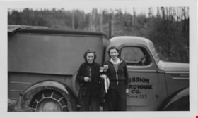
Adell Philips and co-worker in front of truck
https://search.heritageburnaby.ca/link/museumdescription19093
- Repository
- Burnaby Village Museum
- Date
- 1942
- Collection/Fonds
- Earl and Adell Philips family fonds
- Description Level
- Item
- Physical Description
- 1 photograph :b&w ; 7 x 11.5 cm
- Scope and Content
- Photograph of Adell Philips and a co-worker standing in front of a truck with signage on door for Mission Hardware Co.
- Repository
- Burnaby Village Museum
- Collection/Fonds
- Earl and Adell Philips family fonds
- Description Level
- Item
- Physical Description
- 1 photograph :b&w ; 7 x 11.5 cm
- Scope and Content
- Photograph of Adell Philips and a co-worker standing in front of a truck with signage on door for Mission Hardware Co.
- Names
- Philips, Adell Greenwood
- Accession Code
- BV022.11.11
- Access Restriction
- No restrictions
- Reproduction Restriction
- No known restrictions
- Date
- 1942
- Media Type
- Photograph
- Notes
- Title based on contents of photograph
- Note in pencil on verso of photograph reads: "Mission 1942 / Adell & Coworker"
- Stamp in black ink on verso of photograph reads: "4"
Images

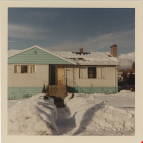
Adell Philips home on Spruce Street
https://search.heritageburnaby.ca/link/museumdescription19092
- Repository
- Burnaby Village Museum
- Date
- 21 Jan. 1969
- Collection/Fonds
- Earl and Adell Philips family fonds
- Description Level
- Item
- Physical Description
- 1 photograph : col. ; 9 x 9 cm
- Scope and Content
- Photograph of Adell Philips' home shortly after she moved in with her son Lea Philips. The house is located at 4085 Spruce Street, Burnaby. The front yard of the house is covered with snow with a shoveled path leading up to the front stairs.
- Repository
- Burnaby Village Museum
- Collection/Fonds
- Earl and Adell Philips family fonds
- Description Level
- Item
- Physical Description
- 1 photograph : col. ; 9 x 9 cm
- Scope and Content
- Photograph of Adell Philips' home shortly after she moved in with her son Lea Philips. The house is located at 4085 Spruce Street, Burnaby. The front yard of the house is covered with snow with a shoveled path leading up to the front stairs.
- Subjects
- Natural Phenomena - Snow
- Geographic Access
- Spruce Street
- Street Address
- 4085 Spruce Street
- Accession Code
- BV022.11.10
- Access Restriction
- No restrictions
- Reproduction Restriction
- No known restrictions
- Date
- 21 Jan. 1969
- Media Type
- Photograph
- Notes
- Title based on contents of photograph
- Note in blue ink on verso of photograph reads: "As it looks when we / moved to 4085 Spruce / Jan 21/69"
- Note in pencil on verso of photograph reads: "#129"
Images

![Adell Philips in front of house, [1939 or 1940] thumbnail](/media/hpo/_Data/_BVM_Images/2022/2022_0011_0017_001.jpg?width=280)
Adell Philips in front of house
https://search.heritageburnaby.ca/link/museumdescription19099
- Repository
- Burnaby Village Museum
- Date
- [1939 or 1940]
- Collection/Fonds
- Earl and Adell Philips family fonds
- Description Level
- Item
- Physical Description
- 1 photograph : b&w ; 25 x 20 cm
- Scope and Content
- Photograph of Adell Philips (nee Greenwood) seated on the lawn in front of her family home on 18th Street in New Westminster.
- Repository
- Burnaby Village Museum
- Collection/Fonds
- Earl and Adell Philips family fonds
- Description Level
- Item
- Physical Description
- 1 photograph : b&w ; 25 x 20 cm
- Scope and Content
- Photograph of Adell Philips (nee Greenwood) seated on the lawn in front of her family home on 18th Street in New Westminster.
- Names
- Philips, Adell Greenwood
- Accession Code
- BV022.11.17
- Access Restriction
- No restrictions
- Reproduction Restriction
- No known restrictions
- Date
- [1939 or 1940]
- Media Type
- Photograph
- Notes
- Title based on contents of photograph
- Note in pencil on verso of photograph reads: “Adell / Approx 1939-1940”
Images
![Adell Philips in front of house, [1939 or 1940] thumbnail](/media/hpo/_Data/_BVM_Images/2022/2022_0011_0017_001.jpg)
![Adell Philips in garden, [1939 or 1940] thumbnail](/media/hpo/_Data/_BVM_Images/2022/2022_0011_0018_001.jpg?width=280)
Adell Philips in garden
https://search.heritageburnaby.ca/link/museumdescription19100
- Repository
- Burnaby Village Museum
- Date
- [1939 or 1940]
- Collection/Fonds
- Earl and Adell Philips family fonds
- Description Level
- Item
- Physical Description
- 1 photograph : b&w ; 9 x 6.5 cm
- Scope and Content
- Photograph of Adell Philips (nee Lillian Odell Greenwood) standing in the garden of her family home on 18th Street in New Westminster. Adell is standing amongst flower beds and there are houses and a picket fence visible in the background.
- Repository
- Burnaby Village Museum
- Collection/Fonds
- Earl and Adell Philips family fonds
- Description Level
- Item
- Physical Description
- 1 photograph : b&w ; 9 x 6.5 cm
- Scope and Content
- Photograph of Adell Philips (nee Lillian Odell Greenwood) standing in the garden of her family home on 18th Street in New Westminster. Adell is standing amongst flower beds and there are houses and a picket fence visible in the background.
- Names
- Philips, Adell Greenwood
- Accession Code
- BV022.11.18
- Access Restriction
- No restrictions
- Reproduction Restriction
- No known restrictions
- Date
- [1939 or 1940]
- Media Type
- Photograph
- Notes
- Title based on contents of photograph
- Note in black ink on verso of photograph reads: “Odell”
- Stamp on verso of photograph reads: “998”
Images
![Adell Philips in garden, [1939 or 1940] thumbnail](/media/hpo/_Data/_BVM_Images/2022/2022_0011_0018_001.jpg)
![Adell Philips in hip waders, [1940] thumbnail](/media/hpo/_Data/_BVM_Images/2022/2022_0011_0014_001.jpg?width=280)
Adell Philips in hip waders
https://search.heritageburnaby.ca/link/museumdescription19096
- Repository
- Burnaby Village Museum
- Date
- [1940]
- Collection/Fonds
- Earl and Adell Philips family fonds
- Description Level
- Item
- Physical Description
- 1 photograph : b&w ; 18 x 13 cm
- Scope and Content
- Photograph of Adell Philips standing outside in a forested area. Adell is wearing hip wader boots and holding a bottle.
- Repository
- Burnaby Village Museum
- Collection/Fonds
- Earl and Adell Philips family fonds
- Description Level
- Item
- Physical Description
- 1 photograph : b&w ; 18 x 13 cm
- Scope and Content
- Photograph of Adell Philips standing outside in a forested area. Adell is wearing hip wader boots and holding a bottle.
- Names
- Philips, Adell Greenwood
- Accession Code
- BV022.11.14
- Access Restriction
- No restrictions
- Reproduction Restriction
- No known restrictions
- Date
- [1940]
- Media Type
- Photograph
- Notes
- Title based on contents of photograph
- Note in pencil and ink on verso of photograph reads: "Adell / Mom / approx 1940? / 287"
Images
![Adell Philips in hip waders, [1940] thumbnail](/media/hpo/_Data/_BVM_Images/2022/2022_0011_0014_001.jpg)
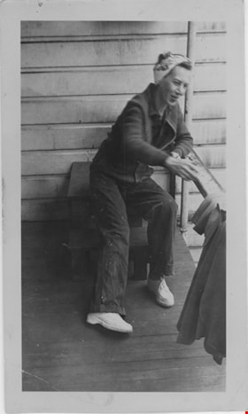
Adell Philips on porch
https://search.heritageburnaby.ca/link/museumdescription19101
- Repository
- Burnaby Village Museum
- Date
- 1943
- Collection/Fonds
- Earl and Adell Philips family fonds
- Description Level
- Item
- Physical Description
- 1 photograph : b&w ; 11.5 x 7 cm
- Scope and Content
- Photograph of Adell Philips (nee Lillian Odell Greenwood) seated on a bench on the porch of her home on Queens Avenue.
- Repository
- Burnaby Village Museum
- Collection/Fonds
- Earl and Adell Philips family fonds
- Description Level
- Item
- Physical Description
- 1 photograph : b&w ; 11.5 x 7 cm
- Scope and Content
- Photograph of Adell Philips (nee Lillian Odell Greenwood) seated on a bench on the porch of her home on Queens Avenue.
- Names
- Philips, Adell Greenwood
- Accession Code
- BV022.11.19
- Access Restriction
- No restrictions
- Reproduction Restriction
- No known restrictions
- Date
- 1943
- Media Type
- Photograph
- Notes
- Title based on contents of photograph
- Note in black ink on verso of photograph reads: “Odell at / Queeens Ave / 1943”
- Stamp on verso of photograph reads: “62”
Images

Administration series
https://search.heritageburnaby.ca/link/archivedescription97125
- Repository
- City of Burnaby Archives
- Date
- 1957-2018
- Collection/Fonds
- Burnaby Historical Society fonds
- Description Level
- Series
- Physical Description
- Textual records and photographs
- Scope and Content
- Series consists of records relating to the establishment, administration and operation of the Burnaby Historical Society. Records include Society meeting minutes, correspondence, and photographs and ephemera from various Society programs and events.
- Repository
- City of Burnaby Archives
- Date
- 1957-2018
- Collection/Fonds
- Burnaby Historical Society fonds
- Series
- Administration series
- Physical Description
- Textual records and photographs
- Description Level
- Series
- Reproduction Restriction
- May be restricted by third party rights
- Accession Number
- 2020-06
- Scope and Content
- Series consists of records relating to the establishment, administration and operation of the Burnaby Historical Society. Records include Society meeting minutes, correspondence, and photographs and ephemera from various Society programs and events.
- Media Type
- Textual Record
- Photograph
- Notes
- Title based on contents of series
Advisory Planning Commission subseries
https://search.heritageburnaby.ca/link/archivedescription96030
- Repository
- City of Burnaby Archives
- Date
- [1960]-2012
- Collection/Fonds
- City Council and Office of the City Clerk fonds
- Description Level
- Subseries
- Physical Description
- 40 folders of textual records + 1 photograph
- Scope and Content
- Subseries consists of commission records for the Advisory Planning Commission including agendas, minutes, reports, and correspondence and a Commission portrait.
- Repository
- City of Burnaby Archives
- Date
- [1960]-2012
- Collection/Fonds
- City Council and Office of the City Clerk fonds
- Series
- Council Committee series
- Subseries
- Advisory Planning Commission subseries
- Physical Description
- 40 folders of textual records + 1 photograph
- Description Level
- Subseries
- Scope and Content
- Subseries consists of commission records for the Advisory Planning Commission including agendas, minutes, reports, and correspondence and a Commission portrait.
- History
- The Advisory Planning Commission was established in July of 1963. The Advisory Planning Commission was the successor to the Town Planning Commission. The Commission was responsible for advising Council on land use matters and reviewing all zoning bylaw amendments before being forwarded to public hearing. The Commission was disbanded on February 20, 2017.
- Media Type
- Textual Record
- Photograph
- Graphic Material
Aerial photograph of Burnaby
https://search.heritageburnaby.ca/link/archivedescription84891
- Repository
- City of Burnaby Archives
- Date
- 1963
- Collection/Fonds
- Allan Amundsen collection
- Description Level
- Item
- Physical Description
- 1 photograph : b&w ; 22.5 x 22.5 cm
- Scope and Content
- Aerial photograph of Burnaby north of Lougheed Highway.
- Repository
- City of Burnaby Archives
- Date
- 1963
- Collection/Fonds
- Allan Amundsen collection
- Physical Description
- 1 photograph : b&w ; 22.5 x 22.5 cm
- Description Level
- Item
- Record No.
- 561-012
- Access Restriction
- In Archives only
- Reproduction Restriction
- No reproduction permitted
- Accession Number
- 2014-08
- Scope and Content
- Aerial photograph of Burnaby north of Lougheed Highway.
- Media Type
- Photograph
- Photographer
- Province of British Columbia
- Notes
- Title based on contents of photograph
- This photo is indentified as BC5061:117 and connects with B.C. air photograph BC5061:118 to the east
- Historic Neighbourhood
- Burnaby Lake (Historic Neighbourhood)
- Planning Study Area
- Parkcrest-Aubrey Area
- Ardingley-Sprott Area
Aerial photograph of Burnaby
https://search.heritageburnaby.ca/link/archivedescription84892
- Repository
- City of Burnaby Archives
- Date
- 1963
- Collection/Fonds
- Allan Amundsen collection
- Description Level
- Item
- Physical Description
- 1 photograph : b&w ; 22.5 x 22.5 cm
- Scope and Content
- Aerial photograph of Burnaby north of Lougheed Highway.
- Repository
- City of Burnaby Archives
- Date
- 1963
- Collection/Fonds
- Allan Amundsen collection
- Physical Description
- 1 photograph : b&w ; 22.5 x 22.5 cm
- Description Level
- Item
- Record No.
- 561-013
- Access Restriction
- In Archives only
- Reproduction Restriction
- No reproduction permitted
- Accession Number
- 2014-08
- Scope and Content
- Aerial photograph of Burnaby north of Lougheed Highway.
- Subjects
- Aerial Photographs
- Media Type
- Photograph
- Photographer
- Province of British Columbia
- Notes
- Title based on contents of photograph
- This photo is indentified as BC5061:118 and connects with B.C. air photograph BC5061:117 to the west and BC5061:119 to the east
- Historic Neighbourhood
- Burnaby Lake (Historic Neighbourhood)
- Lozells (Historic Neighbourhood)
- Planning Study Area
- Parkcrest-Aubrey Area
- Ardingley-Sprott Area
- Sperling-Broadway Area
- Government Road Area
Aerial photograph of Burnaby
https://search.heritageburnaby.ca/link/archivedescription84893
- Repository
- City of Burnaby Archives
- Date
- 1963
- Collection/Fonds
- Allan Amundsen collection
- Description Level
- Item
- Physical Description
- 1 photograph : b&w ; 22.5 x 22.5 cm
- Scope and Content
- Aerial photograph of Burnaby north of Lougheed Highway and west of Sperling Avenue.
- Repository
- City of Burnaby Archives
- Date
- 1963
- Collection/Fonds
- Allan Amundsen collection
- Physical Description
- 1 photograph : b&w ; 22.5 x 22.5 cm
- Description Level
- Item
- Record No.
- 561-014
- Access Restriction
- In Archives only
- Reproduction Restriction
- No reproduction permitted
- Accession Number
- 2014-08
- Scope and Content
- Aerial photograph of Burnaby north of Lougheed Highway and west of Sperling Avenue.
- Subjects
- Aerial Photographs
- Media Type
- Photograph
- Photographer
- Province of British Columbia
- Notes
- Title based on contents of photograph
- This photo is indentified as BC5061:119 and connects with B.C. air photograph BC5061:118 to the west and BC5061:120 to the east
- Geographic Access
- Burnaby Mountain Conservation Area
- Historic Neighbourhood
- Lozells (Historic Neighbourhood)
- Planning Study Area
- Sperling-Broadway Area
- Lake City Area
- Government Road Area
Aerial photograph of Burnaby
https://search.heritageburnaby.ca/link/archivedescription84894
- Repository
- City of Burnaby Archives
- Date
- 1963
- Collection/Fonds
- Allan Amundsen collection
- Description Level
- Item
- Physical Description
- 1 photograph : b&w ; 22.5 x 22.5 cm
- Scope and Content
- Aerial photograph of Burnaby north of Broadway and west of Sperling Avenue.
- Repository
- City of Burnaby Archives
- Date
- 1963
- Collection/Fonds
- Allan Amundsen collection
- Physical Description
- 1 photograph : b&w ; 22.5 x 22.5 cm
- Description Level
- Item
- Record No.
- 561-015
- Access Restriction
- In Archives only
- Reproduction Restriction
- No reproduction permitted
- Accession Number
- 2014-08
- Scope and Content
- Aerial photograph of Burnaby north of Broadway and west of Sperling Avenue.
- Subjects
- Aerial Photographs
- Media Type
- Photograph
- Photographer
- Province of British Columbia
- Notes
- Title based on contents of photograph
- This photo is indentified as BC5061:120 and connects with B.C. air photograph BC5061:119 to the west and BC5061:121 to the east
- Geographic Access
- Burnaby Mountain Conservation Area
- Historic Neighbourhood
- Lozells (Historic Neighbourhood)
- Planning Study Area
- Sperling-Broadway Area
- Lake City Area
- Government Road Area
- Burnaby Mountain Area
Aerial photograph of Burnaby
https://search.heritageburnaby.ca/link/archivedescription84896
- Repository
- City of Burnaby Archives
- Date
- 1963
- Collection/Fonds
- Allan Amundsen collection
- Description Level
- Item
- Physical Description
- 1 photograph : b&w ; 22.5 x 22.5 cm
- Scope and Content
- Aerial photograph of Burnaby north of Broadway and west of Sperling Avenue.
- Repository
- City of Burnaby Archives
- Date
- 1963
- Collection/Fonds
- Allan Amundsen collection
- Physical Description
- 1 photograph : b&w ; 22.5 x 22.5 cm
- Description Level
- Item
- Record No.
- 561-016
- Access Restriction
- In Archives only
- Reproduction Restriction
- No reproduction permitted
- Accession Number
- 2014-08
- Scope and Content
- Aerial photograph of Burnaby north of Broadway and west of Sperling Avenue.
- Subjects
- Aerial Photographs
- Media Type
- Photograph
- Photographer
- Province of British Columbia
- Notes
- Title based on contents of photograph
- This photo is indentified as BC5061:121 and connects with B.C. air photograph BC5061:120 to the west and BC5061:122 to the east
- Geographic Access
- Burnaby Mountain Conservation Area
- Historic Neighbourhood
- Lozells (Historic Neighbourhood)
- Planning Study Area
- Sperling-Broadway Area
- Lake City Area
- Government Road Area
- Burnaby Mountain Area
Aerial photograph of Burnaby
https://search.heritageburnaby.ca/link/archivedescription84903
- Repository
- City of Burnaby Archives
- Date
- 1963
- Collection/Fonds
- Allan Amundsen collection
- Description Level
- Item
- Physical Description
- 1 photograph : b&w ; 22.5 x 22.5 cm
- Scope and Content
- Aerial photograph of Burnaby with the Trans Canada Highway running through and the Forest Lawn Cemetery to the south.
- Repository
- City of Burnaby Archives
- Date
- 1963
- Collection/Fonds
- Allan Amundsen collection
- Physical Description
- 1 photograph : b&w ; 22.5 x 22.5 cm
- Description Level
- Item
- Record No.
- 561-024
- Access Restriction
- In Archives only
- Reproduction Restriction
- No reproduction permitted
- Accession Number
- 2014-08
- Scope and Content
- Aerial photograph of Burnaby with the Trans Canada Highway running through and the Forest Lawn Cemetery to the south.
- Subjects
- Aerial Photographs
- Media Type
- Photograph
- Photographer
- Province of British Columbia
- Notes
- Title based on contents of photograph
- This photo is indentified as BC5062:27 and connects with B.C. air photograph BC5061:26 to the east
- Historic Neighbourhood
- Burnaby Lake (Historic Neighbourhood)
- Planning Study Area
- Douglas-Gilpin Area
- Ardingley-Sprott Area
- Dawson-Delta Area
Aerial photograph of Burnaby
https://search.heritageburnaby.ca/link/archivedescription84907
- Repository
- City of Burnaby Archives
- Date
- 1963
- Collection/Fonds
- Allan Amundsen collection
- Description Level
- Item
- Physical Description
- 1 photograph : b&w ; 22.5 x 22.5 cm
- Scope and Content
- Aerial photograph of Burnaby with the Trans Canada Highway running from through and Burnaby Lake in the south east corner.
- Repository
- City of Burnaby Archives
- Date
- 1963
- Collection/Fonds
- Allan Amundsen collection
- Physical Description
- 1 photograph : b&w ; 22.5 x 22.5 cm
- Description Level
- Item
- Record No.
- 561-025
- Access Restriction
- In Archives only
- Reproduction Restriction
- No reproduction permitted
- Accession Number
- 2014-08
- Scope and Content
- Aerial photograph of Burnaby with the Trans Canada Highway running from through and Burnaby Lake in the south east corner.
- Subjects
- Aerial Photographs
- Media Type
- Photograph
- Photographer
- Province of British Columbia
- Notes
- Title based on contents of photograph
- This photo is indentified as BC5062:26 and connects with B.C. air photograph BC5062:27 to the west and B.C. air photograph BC5062:25 to the east
- Historic Neighbourhood
- Burnaby Lake (Historic Neighbourhood)
- Planning Study Area
- Douglas-Gilpin Area
- Ardingley-Sprott Area
- Burnaby Lake Area
Aerial photograph of Burnaby
https://search.heritageburnaby.ca/link/archivedescription84911
- Repository
- City of Burnaby Archives
- Date
- 1963
- Collection/Fonds
- Allan Amundsen collection
- Description Level
- Item
- Physical Description
- 1 photograph : b&w ; 22.5 x 22.5 cm
- Scope and Content
- Aerial photograph of Burnaby with Lougheed Highway running west to east through the middle of the photograph and the Trans Canada Highway in the lower left segment.
- Repository
- City of Burnaby Archives
- Date
- 1963
- Collection/Fonds
- Allan Amundsen collection
- Physical Description
- 1 photograph : b&w ; 22.5 x 22.5 cm
- Description Level
- Item
- Record No.
- 561-029
- Access Restriction
- In Archives only
- Reproduction Restriction
- No reproduction permitted
- Accession Number
- 2014-08
- Scope and Content
- Aerial photograph of Burnaby with Lougheed Highway running west to east through the middle of the photograph and the Trans Canada Highway in the lower left segment.
- Subjects
- Aerial Photographs
- Media Type
- Photograph
- Photographer
- Province of British Columbia
- Notes
- Title based on contents of photograph
- This photo is indentified as BC5062:22 and connects with B.C. air photograph BC5062:23 to the west and B.C. air photograph BC5062:21
- Historic Neighbourhood
- Lozells (Historic Neighbourhood)
- Burquitlam (Historic Neighbourhood)
- Planning Study Area
- Lake City Area
- Government Road Area
- Burnaby Lake Area
- Lyndhurst Area
- Cariboo-Armstrong Area
Aerial photograph of Burnaby
https://search.heritageburnaby.ca/link/archivedescription84913
- Repository
- City of Burnaby Archives
- Date
- 1963
- Collection/Fonds
- Allan Amundsen collection
- Description Level
- Item
- Physical Description
- 1 photograph : b&w ; 22.5 x 22.5 cm
- Scope and Content
- Aerial photograph of East Burnaby up to North Road and south of the Trans Canada Highway.
- Repository
- City of Burnaby Archives
- Date
- 1963
- Collection/Fonds
- Allan Amundsen collection
- Physical Description
- 1 photograph : b&w ; 22.5 x 22.5 cm
- Description Level
- Item
- Record No.
- 561-031
- Access Restriction
- In Archives only
- Reproduction Restriction
- No reproduction permitted
- Accession Number
- 2014-08
- Scope and Content
- Aerial photograph of East Burnaby up to North Road and south of the Trans Canada Highway.
- Subjects
- Aerial Photographs
- Media Type
- Photograph
- Photographer
- Province of British Columbia
- Notes
- Title based on contents of photograph
- This photo is indentified as BC5062:70 and connects with B.C. air photograph BC5062:21 to the west and BC5062:71 to the east
- Historic Neighbourhood
- East Burnaby (Historic Neighbourhood)
- Planning Study Area
- Cameron Area
- Cariboo-Armstrong Area
Aerial photograph of Burnaby
https://search.heritageburnaby.ca/link/archivedescription84919
- Repository
- City of Burnaby Archives
- Date
- 1963
- Collection/Fonds
- Allan Amundsen collection
- Description Level
- Item
- Physical Description
- 1 photograph : b&w ; 22.5 x 22.5 cm
- Scope and Content
- Aerial photograph of Burnaby in the area of Edmonds Street and Kingsway.
- Repository
- City of Burnaby Archives
- Date
- 1963
- Collection/Fonds
- Allan Amundsen collection
- Physical Description
- 1 photograph : b&w ; 22.5 x 22.5 cm
- Description Level
- Item
- Record No.
- 561-037
- Access Restriction
- In Archives only
- Reproduction Restriction
- No reproduction permitted
- Accession Number
- 2014-08
- Scope and Content
- Aerial photograph of Burnaby in the area of Edmonds Street and Kingsway.
- Subjects
- Aerial Photographs
- Media Type
- Photograph
- Photographer
- Province of British Columbia
- Notes
- Title based on contents of photograph
- This photo is indentified as BC5062:243 and connects with B.C. air photograph BC5062:242 to the east
- Historic Neighbourhood
- Edmonds (Historic Neighbourhood)
- Planning Study Area
- Stride Avenue Area
- Edmonds Area
- Richmond Park Area
- Lakeview-Mayfield Area
- Second Street Area
Aerial photograph of Burnaby
https://search.heritageburnaby.ca/link/archivedescription84920
- Repository
- City of Burnaby Archives
- Date
- 1963
- Collection/Fonds
- Allan Amundsen collection
- Description Level
- Item
- Physical Description
- 1 photograph : b&w ; 22.5 x 22.5 cm
- Scope and Content
- Aerial photograph of Burnaby in the area north east of Kingsway.
- Repository
- City of Burnaby Archives
- Date
- 1963
- Collection/Fonds
- Allan Amundsen collection
- Physical Description
- 1 photograph : b&w ; 22.5 x 22.5 cm
- Description Level
- Item
- Record No.
- 561-038
- Access Restriction
- In Archives only
- Reproduction Restriction
- No reproduction permitted
- Accession Number
- 2014-08
- Scope and Content
- Aerial photograph of Burnaby in the area north east of Kingsway.
- Subjects
- Aerial Photographs
- Media Type
- Photograph
- Photographer
- Province of British Columbia
- Notes
- Title based on contents of photograph
- This photo is indentified as BC5062:242 and connects with B.C. air photograph BC5062:243 to the west
- Historic Neighbourhood
- Edmonds (Historic Neighbourhood)
- Planning Study Area
- Stride Avenue Area
- Edmonds Area
- Lakeview-Mayfield Area
- Second Street Area
Aerial photograph of Burnaby and Coquitlam
https://search.heritageburnaby.ca/link/archivedescription84912
- Repository
- City of Burnaby Archives
- Date
- 1963
- Collection/Fonds
- Allan Amundsen collection
- Description Level
- Item
- Physical Description
- 1 photograph : b&w ; 22.5 x 22.5 cm
- Scope and Content
- Aerial photograph of Burnaby and Coquitlam with North Road running through the centre.
- Repository
- City of Burnaby Archives
- Date
- 1963
- Collection/Fonds
- Allan Amundsen collection
- Physical Description
- 1 photograph : b&w ; 22.5 x 22.5 cm
- Description Level
- Item
- Record No.
- 561-030
- Access Restriction
- In Archives only
- Reproduction Restriction
- No reproduction permitted
- Accession Number
- 2014-08
- Scope and Content
- Aerial photograph of Burnaby and Coquitlam with North Road running through the centre.
- Subjects
- Aerial Photographs
- Media Type
- Photograph
- Photographer
- Province of British Columbia
- Notes
- Title based on contents of photograph
- This photo is indentified as BC5062:21 and connects with B.C. air photograph BC5062:22 to the west and BC5062:70 to the east
- Historic Neighbourhood
- Burquitlam (Historic Neighbourhood)
- Planning Study Area
- Cameron Area
- Lyndhurst Area
- Cariboo-Armstrong Area